
Tropical Storm FLOSSIE (CPAC): Discussions, Analysis and Ima
Moderator: S2k Moderators
Re: Major Hurricane Flossie in CPAC
Making a move towards the islands now. Still on line for miss to south with rain bands hitting south end of Big Island. (Which I visited in 1997)
0 likes


WTPA22 PHFO 120244
TCMCP2
HURRICANE FLOSSIE FORECAST/ADVISORY NUMBER 14
NWS CENTRAL PACIFIC HURRICANE CENTER HONOLULU HI EP092007
0300 UTC SUN AUG 12 2007
HURRICANE CENTER LOCATED NEAR 13.4N 142.2W AT 12/0300Z
POSITION ACCURATE WITHIN 10 NM
PRESENT MOVEMENT TOWARD THE WEST-NORTHWEST OR 290 DEGREES AT 11 KT
ESTIMATED MINIMUM CENTRAL PRESSURE 946 MB
EYE DIAMETER 15 NM
MAX SUSTAINED WINDS 120 KT WITH GUSTS TO 145 KT.
64 KT....... 35NE 25SE 25SW 35NW.
50 KT....... 55NE 45SE 45SW 55NW.
34 KT....... 80NE 65SE 65SW 80NW.
12 FT SEAS..100NE 90SE 90SW 100NW.
WINDS AND SEAS VARY GREATLY IN EACH QUADRANT. RADII IN NAUTICAL
MILES ARE THE LARGEST RADII EXPECTED ANYWHERE IN THAT QUADRANT.
REPEAT...CENTER LOCATED NEAR 13.4N 142.2W AT 12/0300Z
AT 12/0000Z CENTER WAS LOCATED NEAR 13.2N 141.7W
FORECAST VALID 12/1200Z 13.8N 143.9W
MAX WIND 115 KT...GUSTS 140 KT.
64 KT... 30NE 20SE 20SW 30NW.
50 KT... 50NE 40SE 40SW 50NW.
34 KT... 75NE 60SE 60SW 75NW.
FORECAST VALID 13/0000Z 14.4N 146.1W
MAX WIND 105 KT...GUSTS 130 KT.
64 KT... 25NE 20SE 20SW 25NW.
50 KT... 45NE 35SE 35SW 45NW.
34 KT... 70NE 55SE 55SW 70NW.
FORECAST VALID 13/1200Z 15.2N 148.3W
MAX WIND 95 KT...GUSTS 115 KT.
64 KT... 25NE 20SE 20SW 25NW.
50 KT... 50NE 40SE 40SW 50NW.
34 KT... 70NE 50SE 50SW 70NW.
FORECAST VALID 14/0000Z 15.9N 150.5W
MAX WIND 85 KT...GUSTS 105 KT.
50 KT... 45NE 35SE 35SW 45NW.
34 KT... 65NE 45SE 45SW 65NW.
FORECAST VALID 15/0000Z 17.4N 154.6W
MAX WIND 65 KT...GUSTS 80 KT.
50 KT... 35NE 25SE 25SW 35NW.
34 KT... 60NE 40SE 40SW 60NW.
EXTENDED OUTLOOK. NOTE...ERRORS FOR TRACK HAVE AVERAGED NEAR 200 NM
ON DAY 4 AND 225 NM ON DAY 5...AND FOR INTENSITY NEAR 20 KT EACH DAY
OUTLOOK VALID 16/0000Z 18.6N 158.2W
MAX WIND 50 KT...GUSTS 60 KT.
OUTLOOK VALID 17/0000Z 20.2N 161.6W
MAX WIND 40 KT...GUSTS 50 KT.
REQUEST FOR 3 HOURLY SHIP REPORTS WITHIN 300 MILES OF 13.4N 142.2W
NEXT ADVISORY AT 12/0900Z
$$
FORECASTER KODAMA
0 likes
WTPA32 PHFO 120245
TCPCP2
BULLETIN
HURRICANE FLOSSIE ADVISORY NUMBER 14
NWS CENTRAL PACIFIC HURRICANE CENTER HONOLULU HI EP092007
500 PM HST SAT AUG 11 2007
AT 500 PM HST...0300Z...THE CENTER OF HURRICANE FLOSSIE WAS
LOCATED NEAR LATITUDE 13.4 NORTH...LONGITUDE 142.2 WEST OR ABOUT
960 MILES...EAST-SOUTHEAST OF HILO HAWAII AND ABOUT 1170 MILES...
EAST-SOUTHEAST OF HONOLULU HAWAII.
FLOSSIE IS MOVING TOWARD THE WEST-NORTHWEST NEAR 13 MPH...AND THIS
MOTION IS EXPECTED TO CONTINUE OVER THE NEXT 24 HOURS.
MAXIMUM SUSTAINED WINDS ARE NEAR 140 MPH...WITH HIGHER GUSTS. SOME
WEAKENING IS FORECAST DURING THE NEXT 24 HOURS.
HURRICANE FORCE WINDS EXTEND OUTWARD UP TO 40 MILES...FROM THE
CENTER...AND TROPICAL STORM FORCE WINDS EXTEND OUTWARD UP TO 90
MILES.
ESTIMATED MINIMUM CENTRAL PRESSURE IS 946 MB...27.94 INCHES.
REPEATING THE 500 PM HST POSITION...13.4 N...142.2 W. MOVEMENT
TOWARD...WEST-NORTHWEST NEAR 13 MPH. MAXIMUM SUSTAINED WINDS...
140 MPH. MINIMUM CENTRAL PRESSURE...946 MB.
THE NEXT ADVISORY WILL BE ISSUED BY THE CENTRAL PACIFIC HURRICANE
CENTER AT 1100 PM HST.
$$
FORECASTER KODAMA
WTPA42 PHFO 120246
TCDCP2
HURRICANE FLOSSIE DISCUSSION NUMBER 14
NWS CENTRAL PACIFIC HURRICANE CENTER HONOLULU HI EP092007
500 PM HST SAT AUG 11 2007
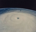
A BURST OF EYEWALL CONVECTION AND SIGNIFICANT WARMING IN THE EYE
ITSELF AS DETECTED IN INFRARED DATA PUSHED SUBJECTIVE DVORAK
INTENSITY ESTIMATES TO 127 KT FROM BOTH PHFO AND SAB. THE
OBJECTIVE DVORAK ESTIMATE CAME IN AT 120 KT. SINCE CLOUD
TOP TEMPERATURES HAVE WARMED SOMEWHAT SINCE THE FIX...WILL FAVOR
THE MORE CONSERVATIVE VALUE OF 120 KT AS THE INITIAL INTENSITY OR
CATEGORY 4 ON THE SAFFIR-SIMPSON SCALE.
FLOSSIE IS MOVING TOWARD THE WEST NORTHWEST AT 11 KT TO THE SOUTH OF
A SUBTROPICAL RIDGE. OBJECTIVE AIDS CONTINUE THIS TREND THOUGH THE
DIFFERENCES...AND THE UNCERTAINTY...BECOME SIGNIFICANT BEYOND DAY 1.
THE GFDL...BAM-DEEP AND NOGAPS CONTINUE TO BE THE NORTHERN OUTLIERS
WHILE THE GFS AND GFS ENSEMBLE ARE THE SOUTHERN OUTLIERS. OF
INTEREST IS THE LARGE SHIFT OF THE HWRF WHICH NOW LIES IN THE
SOUTHERN CLUSTER ALONG WITH THE GFS...ECMWF AND JAPANESE SPECTRAL
MODELS. THE DECIDING FACTOR CONTINUES TO DEPEND ON THE EVENTUAL
STRENGTH OF THE SUBTROPICAL RIDGE AND THE EFFECTS OF INCREASING
VERTICAL SHEAR AND COOLER SEA SURFACE TEMPERATURES ON THE
INTENSITY. IF THE SHEAR AND COOLER WATER SIGNIFICANTLY WEAKEN
FLOSSIE...THE TRACK WILL FOLLOW THE SOUTHERN GROUP WITH A WEST OR
WEST-NORTHWEST MOTION MORE IN LINE WITH THE LOWER LEVEL WINDS. IF
FLOSSIE IS ABLE TO MAINTAIN ITS INTENSITY...THE TRACK WILL BE
TOWARD THE NORTHWEST AND CLOSE TO THE HAWAIIAN ISLANDS. FOR
NOW...WILL KEEP THE FORECAST CLOSE TO THE PREVIOUS FORECAST AND
ROUGHLY DOWN THE MIDDLE OF THE ENVELOPE.
AS FOR INTENSITY...FLOSSIE MAY HAVE REACHED ITS PEAK WITH
SEA SURFACE TEMPERATURES BENEATH THE FORECAST TRACK STEADILY
DECREASING. VERTICAL SHEAR IS ALSO EXPECTED IN INCREASE
CONSIDERABLY BEYOND DAY 2 NEAR 150W. THESE FACTORS SHOULD COMBINE
TO WEAKEN FLOSSIE STEADILY WITH ITS INTENSITY FORECAST TO DROP
BELOW HURRICANE STRENGTH AFTER DAY 3. THIS TREND IS IN LINE WITH
THE SHIPS GUIDANCE.
IT IS IMPORTANT TO NOTE THAT ALTHOUGH THE CURRENT FORECAST KEEPS THE
CENTER OF FLOSSIE SOUTH OF THE HAWAIIAN ISLANDS...A CLOSER APPROACH
CANNOT BE RULED OUT.
FORECAST POSITIONS AND MAX WINDS
INITIAL 12/0300Z 13.4N 142.2W 120 KT
12HR VT 12/1200Z 13.8N 143.9W 115 KT
24HR VT 13/0000Z 14.4N 146.1W 105 KT
36HR VT 13/1200Z 15.2N 148.3W 95 KT
48HR VT 14/0000Z 15.9N 150.5W 85 KT
72HR VT 15/0000Z 17.4N 154.6W 65 KT
96HR VT 16/0000Z 18.6N 158.2W 50 KT
120HR VT 17/0000Z 20.2N 161.6W 40 KT
$$
FORECASTER KODAMA
TCPCP2
BULLETIN
HURRICANE FLOSSIE ADVISORY NUMBER 14
NWS CENTRAL PACIFIC HURRICANE CENTER HONOLULU HI EP092007
500 PM HST SAT AUG 11 2007
AT 500 PM HST...0300Z...THE CENTER OF HURRICANE FLOSSIE WAS
LOCATED NEAR LATITUDE 13.4 NORTH...LONGITUDE 142.2 WEST OR ABOUT
960 MILES...EAST-SOUTHEAST OF HILO HAWAII AND ABOUT 1170 MILES...
EAST-SOUTHEAST OF HONOLULU HAWAII.
FLOSSIE IS MOVING TOWARD THE WEST-NORTHWEST NEAR 13 MPH...AND THIS
MOTION IS EXPECTED TO CONTINUE OVER THE NEXT 24 HOURS.
MAXIMUM SUSTAINED WINDS ARE NEAR 140 MPH...WITH HIGHER GUSTS. SOME
WEAKENING IS FORECAST DURING THE NEXT 24 HOURS.
HURRICANE FORCE WINDS EXTEND OUTWARD UP TO 40 MILES...FROM THE
CENTER...AND TROPICAL STORM FORCE WINDS EXTEND OUTWARD UP TO 90
MILES.
ESTIMATED MINIMUM CENTRAL PRESSURE IS 946 MB...27.94 INCHES.
REPEATING THE 500 PM HST POSITION...13.4 N...142.2 W. MOVEMENT
TOWARD...WEST-NORTHWEST NEAR 13 MPH. MAXIMUM SUSTAINED WINDS...
140 MPH. MINIMUM CENTRAL PRESSURE...946 MB.
THE NEXT ADVISORY WILL BE ISSUED BY THE CENTRAL PACIFIC HURRICANE
CENTER AT 1100 PM HST.
$$
FORECASTER KODAMA
WTPA42 PHFO 120246
TCDCP2
HURRICANE FLOSSIE DISCUSSION NUMBER 14
NWS CENTRAL PACIFIC HURRICANE CENTER HONOLULU HI EP092007
500 PM HST SAT AUG 11 2007
A BURST OF EYEWALL CONVECTION AND SIGNIFICANT WARMING IN THE EYE
ITSELF AS DETECTED IN INFRARED DATA PUSHED SUBJECTIVE DVORAK
INTENSITY ESTIMATES TO 127 KT FROM BOTH PHFO AND SAB. THE
OBJECTIVE DVORAK ESTIMATE CAME IN AT 120 KT. SINCE CLOUD
TOP TEMPERATURES HAVE WARMED SOMEWHAT SINCE THE FIX...WILL FAVOR
THE MORE CONSERVATIVE VALUE OF 120 KT AS THE INITIAL INTENSITY OR
CATEGORY 4 ON THE SAFFIR-SIMPSON SCALE.
FLOSSIE IS MOVING TOWARD THE WEST NORTHWEST AT 11 KT TO THE SOUTH OF
A SUBTROPICAL RIDGE. OBJECTIVE AIDS CONTINUE THIS TREND THOUGH THE
DIFFERENCES...AND THE UNCERTAINTY...BECOME SIGNIFICANT BEYOND DAY 1.
THE GFDL...BAM-DEEP AND NOGAPS CONTINUE TO BE THE NORTHERN OUTLIERS
WHILE THE GFS AND GFS ENSEMBLE ARE THE SOUTHERN OUTLIERS. OF
INTEREST IS THE LARGE SHIFT OF THE HWRF WHICH NOW LIES IN THE
SOUTHERN CLUSTER ALONG WITH THE GFS...ECMWF AND JAPANESE SPECTRAL
MODELS. THE DECIDING FACTOR CONTINUES TO DEPEND ON THE EVENTUAL
STRENGTH OF THE SUBTROPICAL RIDGE AND THE EFFECTS OF INCREASING
VERTICAL SHEAR AND COOLER SEA SURFACE TEMPERATURES ON THE
INTENSITY. IF THE SHEAR AND COOLER WATER SIGNIFICANTLY WEAKEN
FLOSSIE...THE TRACK WILL FOLLOW THE SOUTHERN GROUP WITH A WEST OR
WEST-NORTHWEST MOTION MORE IN LINE WITH THE LOWER LEVEL WINDS. IF
FLOSSIE IS ABLE TO MAINTAIN ITS INTENSITY...THE TRACK WILL BE
TOWARD THE NORTHWEST AND CLOSE TO THE HAWAIIAN ISLANDS. FOR
NOW...WILL KEEP THE FORECAST CLOSE TO THE PREVIOUS FORECAST AND
ROUGHLY DOWN THE MIDDLE OF THE ENVELOPE.
AS FOR INTENSITY...FLOSSIE MAY HAVE REACHED ITS PEAK WITH
SEA SURFACE TEMPERATURES BENEATH THE FORECAST TRACK STEADILY
DECREASING. VERTICAL SHEAR IS ALSO EXPECTED IN INCREASE
CONSIDERABLY BEYOND DAY 2 NEAR 150W. THESE FACTORS SHOULD COMBINE
TO WEAKEN FLOSSIE STEADILY WITH ITS INTENSITY FORECAST TO DROP
BELOW HURRICANE STRENGTH AFTER DAY 3. THIS TREND IS IN LINE WITH
THE SHIPS GUIDANCE.
IT IS IMPORTANT TO NOTE THAT ALTHOUGH THE CURRENT FORECAST KEEPS THE
CENTER OF FLOSSIE SOUTH OF THE HAWAIIAN ISLANDS...A CLOSER APPROACH
CANNOT BE RULED OUT.
FORECAST POSITIONS AND MAX WINDS
INITIAL 12/0300Z 13.4N 142.2W 120 KT
12HR VT 12/1200Z 13.8N 143.9W 115 KT
24HR VT 13/0000Z 14.4N 146.1W 105 KT
36HR VT 13/1200Z 15.2N 148.3W 95 KT
48HR VT 14/0000Z 15.9N 150.5W 85 KT
72HR VT 15/0000Z 17.4N 154.6W 65 KT
96HR VT 16/0000Z 18.6N 158.2W 50 KT
120HR VT 17/0000Z 20.2N 161.6W 40 KT
$$
FORECASTER KODAMA
0 likes

-
neospaceblue
- Tropical Storm

- Posts: 112
- Age: 32
- Joined: Fri Aug 10, 2007 3:17 pm
- Location: Newport News, VA
Re:
neospaceblue wrote:I'm still guessing strong Cat 4 or lower end Cat 5 by this time tomorrow.
Look. I've already asked you twice with your previous posts. Please back up your guesses with some evidence wrt the current environment.
0 likes
-
HurricaneBill
- Category 5

- Posts: 3419
- Joined: Sun Apr 11, 2004 5:51 pm
- Location: East Longmeadow, MA, USA
Re:
Scorpion wrote:How is this occuring in a La Nina/neutral year?
In 1973, a La Nina year, Hurricane Ava reached Category 5 intensity in the EPAC.
0 likes
-
Chris_in_Tampa
- Category 5
- Posts: 5101
- Age: 42
- Joined: Thu Jun 21, 2007 11:06 pm
- Location: Tampa, Florida, USA
- Contact:
Re: Major Hurricane Flossie in CPAC
Until Flossie passes Hawaii, my site is running a special full NHC model suite for Flossie:
http://www.tropicalatlantic.com/temp/plots/09.shtml
Model data available in Google Maps and Google Earth.
http://www.tropicalatlantic.com/temp/plots/09.shtml
Model data available in Google Maps and Google Earth.
0 likes
-
Matt-hurricanewatcher
Re: Major Hurricane Flossie in CPAC
The system is now moving west-northwestward. The trough is about 15-20 lats west of the system,,,,But less then 10 as it heads 3-4 degrees north of were it is at. This is causing a outflow jet, that causes the outflow to enhance poleward on its west and northwest side. As it is moving into it this has enhanced even more. So it would not suprize me over the next 6 hours, this system keeps strengthing. But the TCHP or warm water at depth and how much energy the water(ocean) has will start decreasing as it moves more northward. Also shear should start effecting the system after 12-18 hours of the order of 10-12 knots. Not super unfavorable but for a cat4 it could take it down some. I still like my last night forecast track. In yes this will turn more northward closer to the north side of the cone. I would watch this very closely if I was sitting in Hawaii.
0 likes
Re: Major Hurricane Flossie in CPAC
Matt-hurricanewatcher wrote:The system is now moving west-northwestward. The trough is about 15-20 lats west of the system,,,,But less then 10 as it heads 3-4 degrees north of were it is at. This is causing a outflow jet, that causes the outflow to enhance poleward on its west and northwest side. As it is moving into it this has enhanced even more. So it would not suprize me over the next 6 hours, this system keeps strengthing. But the TCHP or warm water at depth and how much energy the water(ocean) has will start decreasing as it moves more northward. Also shear should start effecting the system after 12-18 hours of the order of 10-12 knots. Not super unfavorable but for a cat4 it could take it down some. I still like my last night forecast track. In yes this will turn more northward closer to the north side of the cone. I would watch this very closely if I was sitting in Hawaii.
Weakening would depend on whether the storm truly is annular or not as some have suggested, probably. However since Flossie is a small system if it isn't annular I'm quite surprised the CPHC aren't going for weakening that's more rapid.
0 likes
-
Derek Ortt
-
Derek Ortt
Re: Major Hurricane Flossie in CPAC
a couple of important points
1. The MPI remains above 120KT along the track
2. The 200mb temps cool along the track, offsetting the slightly lower SST
1. The MPI remains above 120KT along the track
2. The 200mb temps cool along the track, offsetting the slightly lower SST
0 likes
-
Chris_in_Tampa
- Category 5
- Posts: 5101
- Age: 42
- Joined: Thu Jun 21, 2007 11:06 pm
- Location: Tampa, Florida, USA
- Contact:
Re: Major Hurricane Flossie in CPAC
Static image of 0Z early cycle and 18Z late cycle models:

0 likes
-
Coredesat

-
Chris_in_Tampa
- Category 5
- Posts: 5101
- Age: 42
- Joined: Thu Jun 21, 2007 11:06 pm
- Location: Tampa, Florida, USA
- Contact:

Who is online
Users browsing this forum: No registered users and 10 guests