On this day in weather history ..
* 1934 - One of the worst heat waves in the history of the nation commenced. During the last two weeks of the month extreme heat claimed 679 lives in Michigan, including 300 in Detroit alone. (The Weather Channel)
* 1941 - A prolonged heat wave over Washington State finally came to an end. Lightning from untimely thunderstorms was responsible for 598 forest fires. (David Ludlum)
* 1952 - Thunderstorms helped the temperatur at Key West, FL, to dip to 69 degrees, to equal their July record established on the first of July in 1923. (The Weather Channel)
* 1957 - On a warm and sunny day at Wilmington, DE, with a high of 86 degrees, a dust devil suddenly appeared. It tore most the roof off one house, and stripped shingles from a neighboring house. A TV aerial was toppled, and clothes were blown off clothes lines. (The Weather Channel)
* 1987 - Slow moving thunderstorms caused flooding on the Guadalupe River in Texas resulting in tragic loss of life. A bus and van leaving a summer youth camp stalled near the rapidly rising river, just west of the town of Comfort, and a powerful surge of water swept away 43 persons, mostly teenagers. Ten drowned in the floodwaters. Most of the others were rescued from tree tops by helicopter. (The National Weather Summary) (Storm Data)
* 1988 - A dozen cities in the eastern U.S., and six others in California, reported record high temperatures for the date. Downtown San Francisco, CA, with a high of 103 degrees, obliterated their previous record high of 82 degrees. Philadelphia, PA, reported a record five straight days of 100 degree heat, and Baltimore, MD, reported a record eight days of 100 degree weather for the year. Afternoon and evening thunderstorms produced severe weather along the Middle Atlantic Coast, and over southern New England. (The National Weather Summary)
* 1989 - Thunderstorms produced severe weather from South Dakota to Lousiana, with 126 reports of large hail and damaging winds during the day and night. Thunderstorms in Nebraska produced hail four inches in diameter in Frontier County, and at North Platte, causing millions of dollars damage to crops in Frontier County. Thunderstorms in Oklahoma produced wind gusts to 90 mph at Peggs. Tahlequah OK was drenched with 5.25 inches of rain. (Storm Data) (The National Weather Summary)
Thanks to:
http://www.weatherforyou.com/history/
TODAY IN WEATHER HISTORY
Moderator: S2k Moderators
Forum rules

The posts in this forum are NOT official forecast and should not be used as such. They are just the opinion of the poster and may or may not be backed by sound meteorological data. They are NOT endorsed by any professional institution or STORM2K.
-
HURAKAN

- Professional-Met

- Posts: 46084
- Age: 39
- Joined: Thu May 20, 2004 4:34 pm
- Location: Key West, FL
- Contact:
TODAY IN WEATHER HISTORY
0 likes
-
HURAKAN
- Professional-Met
- Posts: 46084
- Age: 39
- Joined: Thu May 20, 2004 4:34 pm
- Location: Key West, FL
- Contact:
On this day in weather history ..
* 1889 - A cloudburst in West Virginia along the small creeks in Wirt County, Jackson County and Wood County claimed twenty lives. Rockport, WV, reported nineteen inches of rain in two hours and ten minutes that Thursday evening. Tygart Creek rose 22 feet in one hour, and villages were swept away on Tygart, Slate, Tucker, and Sandy Creeks. (The Weather Channel)
* 1942 - A record deluge occurred at Smethport in northern Pennsylvania, with 30.7 inches in just six hours. The downpours and resultant flooding in Pennsylvania were devastating. (David Ludlum)
* 1986 - One of the most "photo-genic" tornadoes touched down in the northern suburbs of Minneapolis, MN, during the late afternoon. The very slow moving tornado actually appeared live on the evening news by way of an aerial video taken by the KARE-TV helicopter crew. The tornado, unlike most, was quite the prima donna, staying visible to tens of thousands of persons for thirty minutes. It was moderate in intensity, with winds of 113-157 mph, and caused 650 thousand dollars damage. (Storm Data)
* 1987 - Cool weather prevailed in the western U.S. Seven cities reported record low temperatures for the date, including Alamosa, CO, with a reading of 38 degrees. The low of 52 degrees at Bakersfield, CA, was a record for July. Up to eight inches of snow covered the Northern Sierra Nevada Range of California from a storm the previous day. During that storm, winds gusting to 52 mph at Slide Mountain, NV, produced a wind chill reading of 20 degrees below zero. Susanville, CA, reached 17 degrees that previous day, Blue Canyon, CA, dipped to a July record of 36 degrees, and the high of 44 degrees at Klamath Falls, OR, smashed their previous record for July by ten degrees. (The National Weather Summary)
* 1988 - Sweltering heat continued in California, with record highs of 111 degrees at Redding and 112 degrees at Sacramento. Death Valley, CA, hit 127 degrees. Late afternoon and evening thunderstorms in the Central Plains Region produced baseball size hail at Kimball, NE, wind gusts to 79 mph at Colby, KS, and six inches of rain near Lexington, NE. (The National Weather Summary) (Storm Data)
* 1989 - Thunderstorms produced severe weather in Oklahoma, northern Texas and Arkansas during the afternoon, and into the night. Thunderstorms produced baseball size hail at Stamford, TX, and wind gusts to 92 mph near Throckmorton, TX. Record heat continued in the southwestern U.S. Phoenix AZ reported a record high of 115 degrees, and a 111 degree reading at Midland, TX, was second only to their all-time record high of 112 degrees established sixteen days earlier. (The National Weather Summary)
0 likes
-
Category 5

- Category 5

- Posts: 10074
- Age: 36
- Joined: Sun Feb 11, 2007 10:00 pm
- Location: New Brunswick, NJ
- Contact:
Re: TODAY IN WEATHER HISTORY
This happened to me on this date.
2006: After a high of 104 and a heat index of 114, a severe thunderstorm tears through producing damaging winds, heavy rain, alot of lightning, and an end to an offensive heat wave.
2006: After a high of 104 and a heat index of 114, a severe thunderstorm tears through producing damaging winds, heavy rain, alot of lightning, and an end to an offensive heat wave.
0 likes
-
Category 5
- Category 5
- Posts: 10074
- Age: 36
- Joined: Sun Feb 11, 2007 10:00 pm
- Location: New Brunswick, NJ
- Contact:
Re: TODAY IN WEATHER HISTORY
It was a good idea to start a thread for this instead of having thread after thread for specific events.
0 likes
-
Category 5
- Category 5
- Posts: 10074
- Age: 36
- Joined: Sun Feb 11, 2007 10:00 pm
- Location: New Brunswick, NJ
- Contact:
Re: TODAY IN WEATHER HISTORY
Category 5 wrote:This happened to me on this date.
2006: After a high of 104 and a heat index of 114, a severe thunderstorm tears through producing damaging winds, heavy rain, alot of lightning, and an end to an offensive heat wave.
And my area was hit by a simular thunderstorm today.
0 likes

-
angelwing

- S2K Supporter

- Posts: 4462
- Age: 64
- Joined: Tue Jan 18, 2005 3:06 pm
- Location: Kulpsville, PA
Re: TODAY IN WEATHER HISTORY
Had a massive thunderstorm this afternoon; trying to drive from NJ to SE PA was fun, you couldn't see anything and when I paid my toll at the bridge, the lightening was so close, the toll taker jumped and I jumped, I was just praying to get over the bridge, it was very nasty 
0 likes
-
Siberian Express
- S2K Supporter
- Posts: 99
- Joined: Tue Sep 27, 2005 9:13 pm
- Location: Minnesota, USA
-
HURAKAN
- Professional-Met
- Posts: 46084
- Age: 39
- Joined: Thu May 20, 2004 4:34 pm
- Location: Key West, FL
- Contact:
On July 19 in weather history ..
1886 - A hurricane from the Gulf of Mexico crossed Florida causing great damage from Cedar Keys to Jacksonville. (David Ludlum) - Interesting!!

1960 - Cow Creek and Greenland Ranch in Death Valley, CA, reported morning lows of 102 degrees. The afternoon high at Greenland Ranch was 124 degrees, and the high at Cow Creek that afternoon was 126 degrees. The coolest low for the entire month for both locations was 82 degrees. (The Weather Channel)
1974 - A severe thunderstorm with winds to 80 mph and up to two inches of rain washed out four to five foot deep sections of roadway in Lake Havasu City, AZ. Three persons in a station wagon died as it was carried 3000 feet down a wash by a ten foot wall of water. (The Weather Channel)
1977 - Thunderstorms produced torrential rains over parts of southwestern Pennsylvania. Some places receive more than twelve inches in a seven hour period. The heavy rains cause flash flooding along streams resulting in widespread severe damage. The cloudburst floods Johnstown with up to ten feet of water resulting in 76 deaths, countless injuries, and 424 million dollars damage. (David Ludlum) (The Weather Channel)
1987 - Fifteen cities in the western and the southeastern U.S. reported record low temperatures for the date, including Winnemucca, NV, with a reading of 33 degrees. Flagstaff AZ reported a record low of 34 degrees. Afternoon and evening thunderstorms produced severe weather in New York State and New Jersey. High winds and hail two inches in diameter injured two persons and caused considerable damage to crops in the Pine Island area of central New York State. (The National Weather Summary) (Storm Data)
1988 - Thunderstorms in Nebraska produced more than five inches of rain at Red Cloud, including two inches in fifteen minutes. Torrid temperatures continued over California, with record highs of 115 degrees at Red Bluff and 116 degrees at Redding. (The National Weather Summary) (Storm Data)
1989 - Early morning thunderstorms in the Lower Mississippi Valley produced 5.50 inches of rain south of Alexander, AR, in just ninety minutes, and flash flooding which resulted claimed the life of one woman. Thunderstorms in Indiana produced 4.95 inches of rain in twelve hours east of Muncie. Eight cities in the southwestern U.S. reported record high temperatures for the date, including Las Vegas, NV, with a reading of 115 degrees, and Phoenix, AZ, with a high of 116 degrees. The low that night at Phoenix of 93 degrees was the warmest of record for that location. (The National Weather Summary) (Storm Data)
1886 - A hurricane from the Gulf of Mexico crossed Florida causing great damage from Cedar Keys to Jacksonville. (David Ludlum) - Interesting!!
1960 - Cow Creek and Greenland Ranch in Death Valley, CA, reported morning lows of 102 degrees. The afternoon high at Greenland Ranch was 124 degrees, and the high at Cow Creek that afternoon was 126 degrees. The coolest low for the entire month for both locations was 82 degrees. (The Weather Channel)
1974 - A severe thunderstorm with winds to 80 mph and up to two inches of rain washed out four to five foot deep sections of roadway in Lake Havasu City, AZ. Three persons in a station wagon died as it was carried 3000 feet down a wash by a ten foot wall of water. (The Weather Channel)
1977 - Thunderstorms produced torrential rains over parts of southwestern Pennsylvania. Some places receive more than twelve inches in a seven hour period. The heavy rains cause flash flooding along streams resulting in widespread severe damage. The cloudburst floods Johnstown with up to ten feet of water resulting in 76 deaths, countless injuries, and 424 million dollars damage. (David Ludlum) (The Weather Channel)
1987 - Fifteen cities in the western and the southeastern U.S. reported record low temperatures for the date, including Winnemucca, NV, with a reading of 33 degrees. Flagstaff AZ reported a record low of 34 degrees. Afternoon and evening thunderstorms produced severe weather in New York State and New Jersey. High winds and hail two inches in diameter injured two persons and caused considerable damage to crops in the Pine Island area of central New York State. (The National Weather Summary) (Storm Data)
1988 - Thunderstorms in Nebraska produced more than five inches of rain at Red Cloud, including two inches in fifteen minutes. Torrid temperatures continued over California, with record highs of 115 degrees at Red Bluff and 116 degrees at Redding. (The National Weather Summary) (Storm Data)
1989 - Early morning thunderstorms in the Lower Mississippi Valley produced 5.50 inches of rain south of Alexander, AR, in just ninety minutes, and flash flooding which resulted claimed the life of one woman. Thunderstorms in Indiana produced 4.95 inches of rain in twelve hours east of Muncie. Eight cities in the southwestern U.S. reported record high temperatures for the date, including Las Vegas, NV, with a reading of 115 degrees, and Phoenix, AZ, with a high of 116 degrees. The low that night at Phoenix of 93 degrees was the warmest of record for that location. (The National Weather Summary) (Storm Data)
0 likes
-
Category 5
- Category 5
- Posts: 10074
- Age: 36
- Joined: Sun Feb 11, 2007 10:00 pm
- Location: New Brunswick, NJ
- Contact:
Re: TODAY IN WEATHER HISTORY
Another one for July 18th
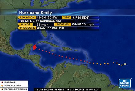
2005: Category 4 Hurricane Emily makes landfall early in the morning near Tulum Mexico with winds of 135mph.
2005: Category 4 Hurricane Emily makes landfall early in the morning near Tulum Mexico with winds of 135mph.
0 likes
-
HURAKAN
- Professional-Met
- Posts: 46084
- Age: 39
- Joined: Thu May 20, 2004 4:34 pm
- Location: Key West, FL
- Contact:
Re: TODAY IN WEATHER HISTORY
Category 5 wrote:Another one for July 18th
2005: Category 4 Hurricane Emily makes landfall early in the morning near Tulum Mexico with winds of 135mph.

What a storm!!!
0 likes
-
Category 5
- Category 5
- Posts: 10074
- Age: 36
- Joined: Sun Feb 11, 2007 10:00 pm
- Location: New Brunswick, NJ
- Contact:
Re:
HURAKAN wrote:Not exactly weather, but it has the word rain!!!
1912 - A meteorite with an estimated mass of 190 kg explodes over the town of Holbrook in Navajo County, Arizona causing approximately 16,000 pieces of debris to rain down on the town.
LOL! That would be one strange sight.
0 likes
-
HURAKAN
- Professional-Met
- Posts: 46084
- Age: 39
- Joined: Thu May 20, 2004 4:34 pm
- Location: Key West, FL
- Contact:
On July 20 in weather history ..
1930 - The temperature at Washington D.C. soared to an all-time record of 106 degrees. The next day Millsboro reached 110 degrees to set a record for the state of Delaware. July 1930 was one of the hottest and driest summers in the U.S., particularly in the Missouri Valley where severe drought conditions developed. Toward the end of the month state records were set for Kentucky with 114 degrees, and Mississippi with 115 degrees. (David Ludlum)
1934 - The temperature at Keokuk, IA, soared to 118 degrees to establish a state record. (The Weather Channel)
1953 - Twenty-two inches of hail reportedly fell northeast of Dickinson, ND. (The Weather Channel)
1986 - The temperature at Charleston, SC, hit 104 degrees for the second day in a row to tie their all-time record high. (The Weather Channel)
1987 - Thunderstorms produced severe weather across Minnesota, Wisconsin and Michigan. Thunderstorms produced wind gusts to 87 mph at Mosinee, WI, and strong thunderstorm winds capsized twenty-six boats on Grand Traverse Bay drowning two women. Thunderstorms produced nine inches of rain at Shakopee, MN, with 7.83 inches reported in six hours at Chaska, MN. Thunderstorms in north central Nebraska produced hail as large as golf balls in southwestern Cherry County, which accumulated to a depth of 12 inches. (The National Weather Summary) (Storm Data)
1988 - The temperature at Redding, CA, soared to an all-time record high of 118 degrees. Showers and thunderstorms produced much needed rains from New England to southern Texas. Salem, IN, was deluged with 7.2 inches of rain resulting in flash flooding. (The National Weather Summary)
1989 - Showers and thunderstorms in the Middle Atlantic Coast Region soaked Wilmington, DE, with 2.28 inches of rain, pushing their total for the period May through July past the previous record of 22.43 inches. Heavy rain over that three month period virtually wiped out a 16.82 inch deficit which had been building since drought conditions began in 1985. Thunderstorms in central Indiana deluged Lebanon with 6.50 inches of rain in twelve hours, and thunderstorms over Florida produced wind gusts to 84 mph at Flagler Beach. (The National Weather Summary) (Storm Data)
0 likes
-
Category 5
- Category 5
- Posts: 10074
- Age: 36
- Joined: Sun Feb 11, 2007 10:00 pm
- Location: New Brunswick, NJ
- Contact:
Re: TODAY IN WEATHER HISTORY
2005: Category 3 Hurricane Emily makes landfall again near San Fernando Mexico with winds of 125mph.
0 likes

-
HURAKAN
- Professional-Met
- Posts: 46084
- Age: 39
- Joined: Thu May 20, 2004 4:34 pm
- Location: Key West, FL
- Contact:
On this day in weather history ..
1911 - The temperature at Painter, WY, dipped to 10 degrees to equal the record low for July for the continental U.S. (The Weather Channel)
1934 - The temperature reached 109 degrees at Cincinnati, OH, to cap their hottest summer of record. The state record for Ohio was established that day with a reading of 113 degrees near the town of Gallipolis. (David Ludlum)
1975 - Six inches of rain fell across Mercer County, NJ, in just ten hours causing the worst flooding in twenty years. Assunpink Creek crested eleven feet above flood stage at Hamilton and Trenton, the highest level of record. Traffic was brought to a standstill, and railway service between New York City and Washington D.C. was cut off for two days. Flooding left 1000 persons homeless, and caused an estimated 25 million dollars damage. (David Ludlum)
1987 - Thunderstorms produced severe weather from Utah to North Dakota, spawning a dozen tornadoes in North Dakota. Thunderstorms in North Dakota also produced baseball size hail at Clifford which caused four million dollars damage, and high winds which toppled a couple of eighty foot towers cutting off power to the town of Blanchard. (The National Weather Summary) (Storm Data)
1988 - While cool air invaded the central U.S., unseasonably hot weather continued over the western states. The temperature at Spring Valley, NV, soared from a morning low of 35 degrees to an afternoon high of 95 degrees. Fallon, NV, reported an all-time record high of 108 degrees, and Death Valley, CA, reported their sixth straight day of 120 degree heat. (The Weather Channel) (The National Weather Summary)
1989 - Afternoon thunderstorms over Florida produced wind gusts to 92 mph at Jacksonville, damaging thirteen light planes at Herlong Field. Five cities in Texas reported record low temperatures for the date. Corpus Christi, TX, equalled their record low for the date with a reading of 71 degrees, and then tied their record high for the date that afternoon with a reading of 97 degrees. (The National Weather Summary) (Storm Data)
0 likes
Return to “USA & Caribbean Weather”
Who is online
Users browsing this forum: No registered users and 118 guests