WEAK AREA OF LOW PRESSURE ALONG THE LOUISIANA COAST

This is the general tropical discussion area. Anyone can take their shot at predicting a storms path.

Moderator: S2k Moderators

Forum rules

The posts in this forum are NOT official forecasts and should not be used as such. They are just the opinion of the poster and may or may not be backed by sound meteorological data. They are NOT endorsed by any professional institution or STORM2K. For official information, please refer to products from the National Hurricane Center and National Weather Service.

Help Support Storm2K
Message
Author
chadtm80

WEAK AREA OF LOW PRESSURE ALONG THE LOUISIANA COAST

#1 Postby chadtm80 » Sat Jun 21, 2003 2:05 pm

What does that mean???????

well, realy nothing more than Showers and thunderstorms for the NE gulf of mexico and Florida over the next couple of days...

Well we asked for rain my fellow Floridians, God has realy come through for us the last week or so :lol:


Image
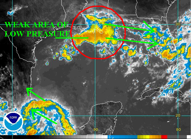
Convection in the S BOC has realy crapped out over the last hours and is nearing the coast south of tampico
Last edited by chadtm80 on Sat Jun 21, 2003 2:09 pm, edited 1 time in total.
0 likes   

ColdFront77

#2 Postby ColdFront77 » Sat Jun 21, 2003 2:09 pm

Interesting thing is, the wind shear over the northern Gulf of Mexico to Florida; especially a bit ESE of the convectin moving off Louisiana.

The upper level divergence was a bit positive and the latest data indicate it about even, neither positive nor negative.

More often than not the last few days, it (upper level divergence) has been positive over most of the Gulf of Mexico.
0 likes   

User avatar
wx247
S2K Supporter
S2K Supporter
Posts: 14279
Age: 41
Joined: Wed Feb 05, 2003 10:35 pm
Location: Monett, Missouri
Contact:

#3 Postby wx247 » Sat Jun 21, 2003 2:10 pm

I agree... the SE (especially Florida) has been pummeled the last few days. As far as the low along the Louisiana coast, I agree in no development but you don't need it to get lots of rain.
0 likes   
Personal Forecast Disclaimer:
The posts in this forum are NOT official forecast and should not be used as such. They are just the opinion of the poster and may or may not be backed by sound meteorological data. They are NOT endorsed by any professional institution or storm2k.org. For official information, please refer to the NHC and NWS products.

Rainband

#4 Postby Rainband » Sat Jun 21, 2003 2:38 pm

533
fxus62 ktbw 211720
afdtbw


West central and southwest Florida forecast discussion
National Weather Service Tampa Bay area - Ruskin Florida
120 PM EDT Sat Jun 21 2003


Numerous showers and thunderstorms continue to move over the area
this afternoon. Brief breaks in the cloud cover earlier has added to
heating increasing instability the fill in with more thunderstorms.
Flood Watch continues with abundant rainfall expected over already
saturated areas as many rivers remain in or near flood.


Models differ considerably through 60 hours. Believe GFS overdone
with surface low developing on front over the northern Gulf then into the
eastern Gulf. Will go with more of the same for tonight and Sunday.
Westerly flow to continue to keep abundant tropical moisture in place
as upper level shortwaves/positive vorticity advection rotate overhead. Moisture to slowly
sink southward in time...so will hold the highest probability of precipitation south and
trend lower into the north. Temperatures to remain steady. Will continue
Flood Watch all areas into Sunday...with more expected rainfall in
already saturated areas. Expect to see more in the way of sun and
lower scattered probability of precipitation on Monday. Temperatures to warm to near normal.


Extended(tue-sat)...latest GFS solution now differing from previous
runs with respect to drier air moving in from the north for the
beginning of the upcoming work week. 12z run now depicts upper
troughiness and ample tropical moisture remaining in place across the
central and southern forecast area through Thursday with the GFS depicting a
weak (1010-1013mb) spurious looking surface low lurking just offshore the
Florida west coast through Thursday. This solution is rather suspect at
this time...so confidence in its forecast is on the low side so will
maintain near climatology probability of precipitation across central and southern zones...with
slightly lower values far north...where somewhat drier air will
reside.


Beyond this the MRF shows a surface ridge axis developing across the
south-Central Peninsula for Friday and Saturday...so a more typical
Summer time regime should be the rule with mainly afternoon and early
evening convection generated by afternoon sea breeze circulations. No
real temperature changes expected through the period with readings
continuing at or slightly above seasonal levels.


Marine...SW/westerly flow to continue with little change expected.
No highlights expected.


Fire weather...no highlights.


Preliminary numbers:
bkv 073/088 072/090 5533
tpa 076/088 075/089 7734
gif 075/089 074/090 6734
srq 076/087 074/088 7854
fmy 074/088 074/089 7865


Tbw...Flood Watch for all zones into Sunday.


Rd/jm
0 likes   

ColdFront77

#5 Postby ColdFront77 » Sat Jun 21, 2003 3:25 pm

The sun broke out a few times this morning into this afternoon. A heavy shower moved through after the sun was only out for five or so minute. The dewpoint was 75 and rose to the upper 70's in the last hour across central Florida; thus the air is certainly tropical.
0 likes   

User avatar
Toni - 574
Category 1
Category 1
Posts: 493
Joined: Wed May 28, 2003 9:20 pm
Location: W. Central Florida

#6 Postby Toni - 574 » Sat Jun 21, 2003 3:29 pm

Don't know about you Jonathan, but I am just about rained out in the St. Pete area. I have not seen any major flooding from my immediate area, but the rain can stop any time now. Sounds like we are in for a lot more in the next couple of days. As far as the models are concerned we will just have to wait and see. The gulf has been very unsettled and the models has a lot to analyze. I think we are just in for more of the same old -same old weather patterm that we have seen this past week. :roll:

Toni :multi:
0 likes   

Rainband

#7 Postby Rainband » Sat Jun 21, 2003 3:35 pm

Toni - 574 wrote:Don't know about you Jonathan, but I am just about rained out in the St. Pete area. I have not seen any major flooding from my immediate area, but the rain can stop any time now. Sounds like we are in for a lot more in the next couple of days. As far as the models are concerned we will just have to wait and see. The gulf has been very unsettled and the models has a lot to analyze. I think we are just in for more of the same old -same old weather patterm that we have seen this past week. :roll:

Toni :multi:
I agree..I think the model is over reacting to the atmospheric conditions too.. I hope so..we don't need any more heavy rain events for a while!!!! :wink:
0 likes   

ncstorm

#8 Postby ncstorm » Sat Jun 21, 2003 3:37 pm

I don't know much about weather but I can say that that area of showers looks like it has a chance to develop. :o
0 likes   

Anonymous

#9 Postby Anonymous » Sat Jun 21, 2003 3:52 pm

The low south of Lousiana is the same low the models are trying to develop over the Bahamas in a week.
0 likes   


Return to “Talkin' Tropics”

Who is online

Users browsing this forum: Stormybajan, Ulf and 37 guests