March 8-15, 2007 Idea: March Goes Mild

Winter Weather Discussion

Moderator: S2k Moderators

Forum rules

The posts in this forum are NOT official forecast and should not be used as such. They are just the opinion of the poster and may or may not be backed by sound meteorological data. They are NOT endorsed by any professional institution or STORM2K.

Help Support Storm2K
Message
Author
donsutherland1
S2K Analyst
S2K Analyst
Posts: 2718
Joined: Mon Sep 15, 2003 8:49 pm
Location: New York

March 8-15, 2007 Idea: March Goes Mild

#1 Postby donsutherland1 » Mon Feb 26, 2007 2:18 pm

The chill that is likely to pass through the East during the first week in March is likely to be replaced by a milder regime that should stretch across much of the United States in the March 8-15 timeframe. Only the Pacific Northwest and Northern Plains might be brushed by cooler air masses that will likely remain largely north of the U.S.-Canada border. The Southwestern States will remain in a much above normal temperature regime. Whether or not that area of warmth eventually pushes deeper into the U.S. and brings much above normal readings across the Central and Southern Plains and then eastward remains to be seen.

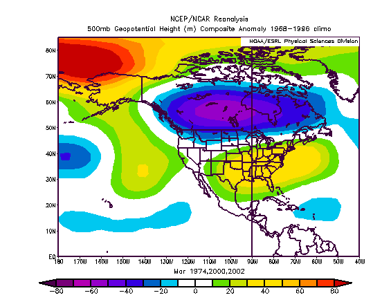
Through much of the period, the 500 mb pattern across North America should resemble that which is typical of situations following the demise of a AO- regime (which is imminent) without the occurrence of a strong blocking episode prior to that demise.

Historic Experience:
Image

Forecast 500 mb Pattern (360 hours):
Image

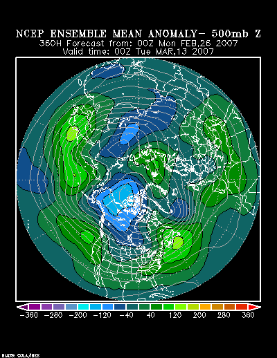
It should be noted that the latest run of the GSM argues strongly against my thinking. The GSM forecasts that the Northern Plains will average 4°-8° above normal during the 3/10-17 timeframe while the Mid-Atlantic and Northeast will average 4°-8° below normal during that same period of time. Given the likely AO+, historic experience following the end of medium-duration AO- regimes that commenced in the 1/15-2/15 timeframe, and the continuing lack of a NAO-, I don’t agree with the GSM. Instead, I believe there could be a short-duration push of cold air, possibly in the wake of a storm that could cut for the Great Lakes.

Farther down the road, it remains to be seen whether the very cold air that is likely to remain locked up in northwestern Canada ever makes a push for the U.S. or eventually slowly slides eastward across Canada and modifies as it does so. There are some subtle hints in the ensemble guidance that a PNA+ may slowly try to re-emerge down the road. If that happens, odds of the cold eventually pushing into the U.S. might increase. At the same time, the persistent area of much above normal readings for the season in the Southwest could eventually make a run at a larger area. If that were to happen, it would likely occur after March 10 (possibly the March 10-20 timeframe).

My thinking for the average temperature anomalies during the 3/8-15 period is as follows:

Average Regional Temperature Anomalies (3/8-15):
Northeast: Somewhat above normal
Mid-Atlantic: Somewhat above normal
Southeast: Somewhat above normal
Great Lakes: Somewhat above normal
Northern Plains: Near normal
Central Plains: Somewhat above normal
Southern Plains: Above normal
Pacific Northwest: Near normal
Southwest/Rest of West Coast: Much above normal

For the major cities from Washington, DC to Boston, the 3/8-15 period is likely to feature:

- Nights generally in the 30s in Boston, New York City, Philadelphia, and Washington, DC.
- Days mainly in the 40s and 50s in Boston, New York City and Philadelphia, and 50s in Washington, DC.
- One or two days with a high temperature of 60° or above in Washington, DC and possibly Philadelphia.

In the Southeast, Atlanta will likely see highs generally in the 60s. Lows should generally be in the 40s. Elsewhere, Burlington will likely see highs mainly in the 30s and with some 40s possible. Lows should be mainly in the 20s.

Occasional Historic Tidbit:

March 1864: Petersburg, Virginia: The heaviest snowstorm of two winters, it is presumed, did not slight Petersburg yesterday and last night [March 22].—The average depth is about twelve inches, and some affirm that it is deeper. Today was ushered in with a cloudless sky, and merry ringing of sleigh bells, the latter pastime at the tune of twenty dollars an hour to those who indulged.

Source:The Baltimore Sun, March 30, 1864
0 likes   

donsutherland1
S2K Analyst
S2K Analyst
Posts: 2718
Joined: Mon Sep 15, 2003 8:49 pm
Location: New York

Re: March 8-15, 2007 Idea: March Goes Mild

#2 Postby donsutherland1 » Mon Mar 19, 2007 2:35 pm

Verification:

The chill that is likely to pass through the East during the first week in March is likely to be replaced by a milder regime that should stretch across much of the United States in the March 8-15 timeframe. Only the Pacific Northwest and Northern Plains might be brushed by cooler air masses that will likely remain largely north of the U.S.-Canada border. The Southwestern States will remain in a much above normal temperature regime. Whether or not that area of warmth eventually pushes deeper into the U.S. and brings much above normal readings across the Central and Southern Plains and then eastward remains to be seen.


An extremely frigid air mass departed from the East and temperatures rebounded strongly. In spite of the very cold start to the period, the overall 3/8-15 temperatures averaged 2°-3° above normal from Washington, DC to Boston. The Southwest experienced extreme early-season heat.

My thinking for the average temperature anomalies during the 3/8-15 period is as follows:

Average Regional Temperature Anomalies (3/8-15):
Northeast: Somewhat above normal; Actual: Somewhat above normal
Mid-Atlantic: Somewhat above normal; Actual: Above normal
Southeast: Somewhat above normal; Actual: Above normal
Great Lakes: Somewhat above normal; Actual: Above normal
Northern Plains: Near normal; Actual: Above normal
Central Plains: Somewhat above normal; Actual: Above normal to much above normal
Southern Plains: Above normal; Actual: Above normal
Pacific Northwest: Near normal; Actual: Near normal to somewhat above normal
Southwest/Rest of West Coast: Much above normal; Actual: Much above normal

For the major cities from Washington, DC to Boston, the 3/8-15 period is likely to feature:

- Nights generally in the 30s in Boston, New York City, Philadelphia, and Washington, DC.
- Days mainly in the 40s and 50s in Boston, New York City and Philadelphia, and 50s in Washington, DC.
- One or two days with a high temperature of 60° or above in Washington, DC and possibly Philadelphia.

Nights:
Boston: 0s: 2; 20s: 2; 30s: 4; 40s:1
New York City: 10s: 2; 30s: 4; 40s: 2
Philadelphia: 10s: 2; 20s: 2; 30s: 2; 40s: 2
Washington, DC: 20s: 2; 30s: 3; 40s: 2; 50s: 1

Days:
Boston: 20s: 1; 30s: 1; 50s: 4; 60s: 2
New York City: 30s: 2; 50s: 4; 60s: 1; 70s: 1
Philadelphia: 30s: 1; 40s: 1; 50s: 2; 60s: 3; 70s: 1
Washington, DC: 40s: 2; 50s: 2; 60s: 1; 70s: 2; 80s: 1

In the Southeast, Atlanta will likely see highs generally in the 60s. Lows should generally be in the 40s. Elsewhere, Burlington will likely see highs mainly in the 30s and with some 40s possible. Lows should be mainly in the 20s.

Atlanta (high temperatures):
50s: 1; 60s: 1; 70s: 6

Atlanta (low temperatures):
40s: 2; 50s: 4; 60s: 2

Burlington (high temperatures):
10s: 1; 20s: 1; 40s: 3; 50s: 3

Burlington (low temperatures):
-10s: 1; -0s: 1; 20s: 4; 30s: 1; 40s: 1
0 likes   


Return to “Winter Weather”

Who is online

Users browsing this forum: No registered users and 4 guests