2/13-14/2007 Storm: My Snowfall Estimates

Winter Weather Discussion

Moderator: S2k Moderators

Forum rules

The posts in this forum are NOT official forecast and should not be used as such. They are just the opinion of the poster and may or may not be backed by sound meteorological data. They are NOT endorsed by any professional institution or STORM2K.

Help Support Storm2K
Message
Author
donsutherland1
S2K Analyst
S2K Analyst
Posts: 2718
Joined: Mon Sep 15, 2003 8:49 pm
Location: New York

2/13-14/2007 Storm: My Snowfall Estimates

#1 Postby donsutherland1 » Mon Feb 12, 2007 4:28 pm

In the options trading market, one finds that American options (those that be exercised e.g., converted to stock, at any time prior to expiration) the market value generally exceeds the intrinsic value. This premium represents, in part, the value that is placed on time. In other words, there is a perceived value of waiting. The same can hold true with forecasting. As the model runs roll in, rather than lurching wildly from one run to another, there is value in maintaining a degree of continuity and slowly adjusting toward the changes in the modeling. This gives the forecaster time to avoid extreme swings e.g., from heavy snow to heavy rain and then back again, based on each new model run. Such an approach can build a measure of confidence, especially as it allows for the models to work toward a consensus.

After waiting through yesterday into this afternoon, I am now reasonably confident that even as there remain some sizable differences in the modeling, one will likely see a primary system track toward eastern Kentucky or West Virginia where it will fade and secondary system develop somewhere near the South Carolina/North Carolina border and then track northeastward from there. Unfortunately, the combination of the primary low and position of the 850 mb low suggests that a wedge of warm air will sweep northward. The warm tongue will be deep enough so that it cannot be overcome by the storm’s dynamics. As a result, the coastal plain and cities outside of those in northern New England or western New York State are likely to see a change to sleet, freezing rain, or rain.

Unfortunately, in many of these cities, the snowfall will be much less than what I had thought was possible late last week e.g., I had thought the DCA-BWI-HGR-PHL area would likely see more than 6” with a foot or more possible.

It should be noted that the 18z run of the NAM is coming in colder than the 12z run. While this won’t significantly alter the outcome for the coastal plain, it could suggest the emerging potential for a longer period of snow, particularly for interior sections that might otherwise transition sooner.

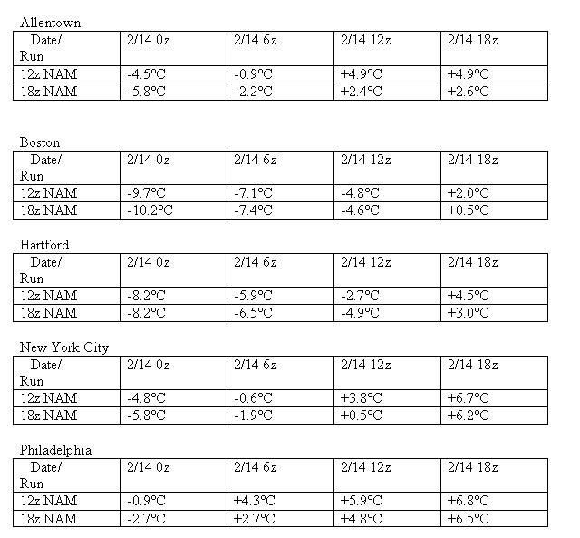
Comparisons of forecast 850 mb temperatures for select cities follow:

Image

At this time, my initial snowfall estimates are as follows:

Albany: 12”-18”
Allentown: 2”-4”
Baltimore: 2” or less
Binghamton: 8”-16”
Boston: 3”-7”
Burlington: 16”-24”
Harrisburg: 3”-6”
Hartford: 4”-8”
New York City: 1”-3”
Newark: 1”-3”
Philadelphia: 1”-3”
Providence: 2”-5”
Syracuse: 14”-20”
Washington, DC: DCA: 2” or less; IAD: 2” or less
Watertown: 8”-16”
Worcester: 5”-10”
0 likes   

User avatar
angelwing
S2K Supporter
S2K Supporter
Posts: 4462
Age: 63
Joined: Tue Jan 18, 2005 3:06 pm
Location: Kulpsville, PA

#2 Postby angelwing » Mon Feb 12, 2007 4:40 pm

Thank you Don! Kinda interesting, the city was already putting brine down on State road about 20 mins ago, first time I've seen them put it down so early.
0 likes   

Coredesat

#3 Postby Coredesat » Mon Feb 12, 2007 6:20 pm

Interesting discussion, even though I don't really like the outcome. It looks like just another dud storm for Richmond.
0 likes   

User avatar
Category 5
Category 5
Category 5
Posts: 10074
Age: 35
Joined: Sun Feb 11, 2007 10:00 pm
Location: New Brunswick, NJ
Contact:

#4 Postby Category 5 » Mon Feb 12, 2007 7:14 pm

Are the flurries coming toward us now related to the main storm?
0 likes   

User avatar
Stephanie
S2K Supporter
S2K Supporter
Posts: 23843
Age: 63
Joined: Thu Feb 06, 2003 9:53 am
Location: Glassboro, NJ

#5 Postby Stephanie » Mon Feb 12, 2007 9:22 pm

They're probably putting the brine down in anticipation of the ice we may be getting later tomorrow.

Ice stinks!! :eek:
0 likes   

User avatar
Nimbus
Category 5
Category 5
Posts: 5300
Joined: Mon Jul 19, 2004 10:54 am

#6 Postby Nimbus » Mon Feb 12, 2007 9:33 pm

Warm moist air overunning a cold high pressure dome is a recipe for freezing rain. Iced up tree branches and power lines combined with high winds are a bad mix. There will be a lot of power outages with this storm in areas that change over.
0 likes   

User avatar
angelwing
S2K Supporter
S2K Supporter
Posts: 4462
Age: 63
Joined: Tue Jan 18, 2005 3:06 pm
Location: Kulpsville, PA

#7 Postby angelwing » Mon Feb 12, 2007 9:35 pm

I was just surprised it was so early, they usually wait until the storm starts. Also just took a break outside and the road here by the hospital is brined too.
0 likes   

User avatar
Category 5
Category 5
Category 5
Posts: 10074
Age: 35
Joined: Sun Feb 11, 2007 10:00 pm
Location: New Brunswick, NJ
Contact:

Re: 2/13-14/2007 Storm: My Snowfall Estimates

#8 Postby Category 5 » Mon Feb 12, 2007 10:17 pm

donsutherland1 wrote:Philadelphia: 1”-3”


Can we put a "0" after the 1 and 3? :lol: :wink:
0 likes   

User avatar
ohiostorm
Category 5
Category 5
Posts: 1582
Age: 40
Joined: Sat Oct 12, 2002 2:51 pm
Location: Orlando, FL
Contact:

#9 Postby ohiostorm » Mon Feb 12, 2007 10:41 pm

What about Pittsburgh?
0 likes   

JBG
Tropical Storm
Tropical Storm
Posts: 146
Joined: Fri Apr 29, 2005 12:34 pm
Location: New York City area
Contact:

#10 Postby JBG » Mon Feb 12, 2007 10:42 pm

I wonder if the "split jet stream" scenarios almost always make a heavy I-95 storm unlikely. Are there any examples of Kocin-Uccinelli storms in a split jet envirnoment?
0 likes   

User avatar
Category 5
Category 5
Category 5
Posts: 10074
Age: 35
Joined: Sun Feb 11, 2007 10:00 pm
Location: New Brunswick, NJ
Contact:

#11 Postby Category 5 » Mon Feb 12, 2007 10:53 pm

I'm hearing about a possible few inches on the wrap around.
0 likes   

User avatar
Hurricaneman
Category 5
Category 5
Posts: 7351
Age: 45
Joined: Tue Aug 31, 2004 3:24 pm
Location: central florida

#12 Postby Hurricaneman » Wed Feb 14, 2007 11:52 am

I think it will be all rain for me from here on out
0 likes   


Return to “Winter Weather”

Who is online

Users browsing this forum: No registered users and 3 guests