After waiting through yesterday into this afternoon, I am now reasonably confident that even as there remain some sizable differences in the modeling, one will likely see a primary system track toward eastern Kentucky or West Virginia where it will fade and secondary system develop somewhere near the South Carolina/North Carolina border and then track northeastward from there. Unfortunately, the combination of the primary low and position of the 850 mb low suggests that a wedge of warm air will sweep northward. The warm tongue will be deep enough so that it cannot be overcome by the storm’s dynamics. As a result, the coastal plain and cities outside of those in northern New England or western New York State are likely to see a change to sleet, freezing rain, or rain.
Unfortunately, in many of these cities, the snowfall will be much less than what I had thought was possible late last week e.g., I had thought the DCA-BWI-HGR-PHL area would likely see more than 6” with a foot or more possible.
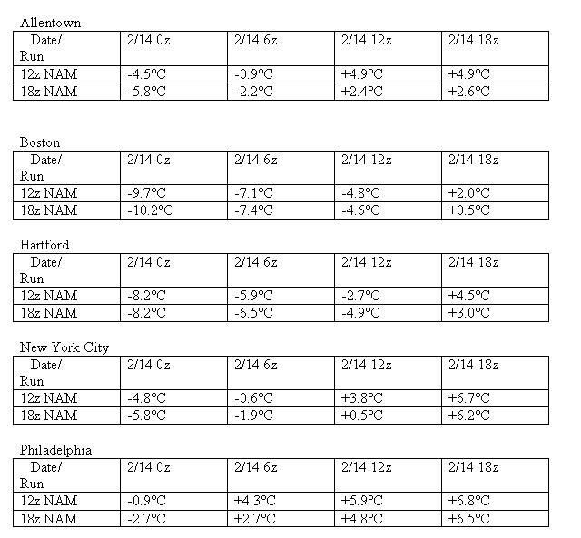
It should be noted that the 18z run of the NAM is coming in colder than the 12z run. While this won’t significantly alter the outcome for the coastal plain, it could suggest the emerging potential for a longer period of snow, particularly for interior sections that might otherwise transition sooner.
Comparisons of forecast 850 mb temperatures for select cities follow:

At this time, my initial snowfall estimates are as follows:
Albany: 12”-18”
Allentown: 2”-4”
Baltimore: 2” or less
Binghamton: 8”-16”
Boston: 3”-7”
Burlington: 16”-24”
Harrisburg: 3”-6”
Hartford: 4”-8”
New York City: 1”-3”
Newark: 1”-3”
Philadelphia: 1”-3”
Providence: 2”-5”
Syracuse: 14”-20”
Washington, DC: DCA: 2” or less; IAD: 2” or less
Watertown: 8”-16”
Worcester: 5”-10”
 The posts in this forum are NOT official forecast and should not be used as such. They are just the opinion of the poster and may or may not be backed by sound meteorological data. They are NOT endorsed by any professional institution or


