The posts in this forum are NOT official forecast and should not be used as such. They are just the opinion of the poster and may or may not be backed by sound meteorological data. They are NOT endorsed by any professional institution or

• The cold came in largely on time.
• The January 28-February 20 period is likely to prove the snowiest of the winter.
• The snowfall during that timeframe, especially the February 1-7 period, has underperformed with respect to the big cities of the East Coast.
In my February 16-22 discussion posted on February 6, I discussed the importance of blocking in determining how the month could end. I noted:
Finally, beyond this period [February 16-22], there is much uncertainty as to whether a stronger cold regime could redevelop. Such a regime would depend on the development of a strong block. The absence, so far, of such blocking during the winter and less than impressive ensemble guidance likely suggests that from this far out, odds may lean against the development of such a block. If so, there may be the prospect of the commencement of a more pronounced warming beyond the timeframe of this discussion, even if its duration is not lengthy.
At the time, I felt the odds leaned against the development of such a block. Now, almost a week later, the development of such blocking appears even less likely. Hence, even as the snowfall underperformed overall this month, hopes for renewed meaningful snowfall will probably have to hinge on March, as there are growing indications that the closing days of February will likely yield budding signs of spring. A short-duration spike in temperatures is possible during that period.
My thinking for the average temperature anomalies during the 2/23-28 period is as follows:
Average Regional Temperature Anomalies (2/23-28):
Northeast: Above normal
Mid-Atlantic: Above normal
Southeast: Above normal
Great Lakes: Above normal
Northern Plains: Near normal
Central Plains: Near normal
Southern Plains: Near normal to somewhat above normal
Pacific Northwest: Somewhat below normal to near normal
Southwest/Rest of West Coast: Somewhat below normal to near normal
For the major cities from Washington, DC to Boston, the 2/23-28 period is likely to feature:
- Nights generally in the 20s and 30s in Boston, and 30s in New York City, Philadelphia, and Washington, DC.
- Days mainly in the 30s and 40s in Boston, 40s in New York City and Philadelphia, and 40s and 50s in Washington, DC.
- At least one day with a high temperature at or above 60° in Washington, DC and one or more days at 50° or above in Boston, New York City, and Philadelphia.
In the Southeast, Atlanta will likely see highs generally in the 50s with some 60s possible. Lows should generally be in the 30s and 40s. Elsewhere, Burlington will likely see highs mainly in the 30s. Lows should be in 20s with some teens. A high temperature at or above 40° is possible on one day.
The Importance of Blocking in March:
As the jet migrates northward, the absence or presence blocking plays a crucial role in helping determine whether the Mid-Atlantic/Southeast/Great Lakes is colder or warmer than normal.
March NAO > 0:
New England: Cold: 41%
Mid-Atlantic: 19%
Southeast: 33%
Great Lakes: 37%
March NAO < 0:
New England: Cold: 63%
Mid-Atlantic: 63%
Southeast: 70%
Great Lakes: 70%
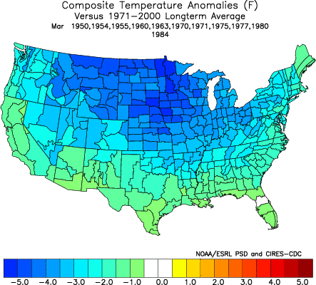
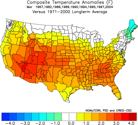
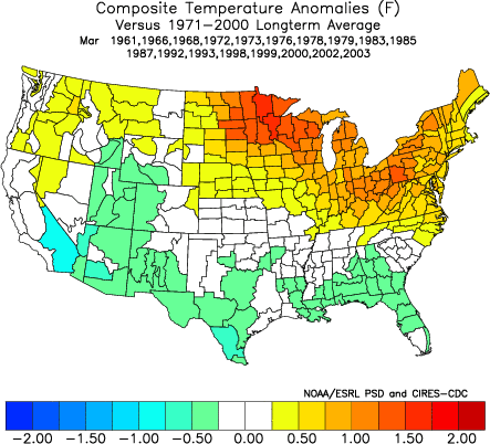
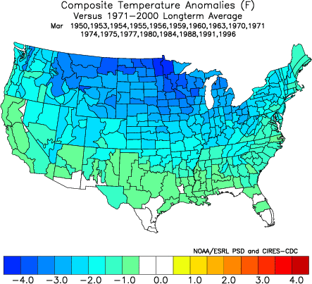
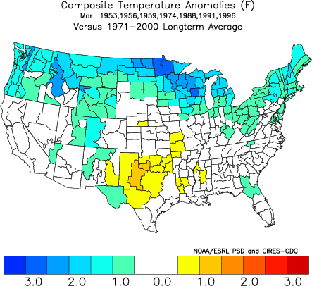
The following maps illustrate nationwide temperature anomalies at given NAO levels:
March NAO +1.00 or above:
March NAO 0 to +0.99:
March NAO -0.99 to 0:
March NAO -1.00 or below:

As the NAO rises toward 0 (the block grows weaker), the area of cold anomalies also shifts northward as the jet stream grows less suppressed.
March NAO -0.30 to 0:
March NAO -0.99 to -0.31: