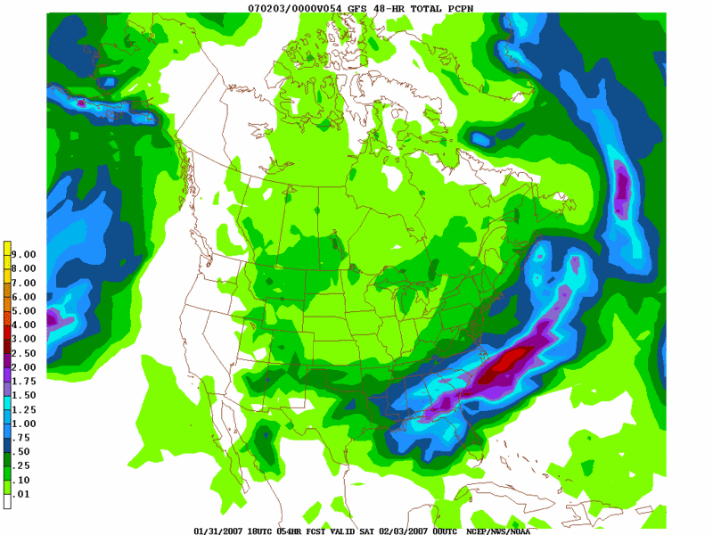
If one is looking for a degree of consistency, the ECMWF and GFS ensemble means have been quite a bit more consistent than either the NAM or operational GFS. In fact, the 1/31 0z GFS is an outlier solution among the numerous possibilities that had been displayed in recent days. I strongly suspect that it will be an outlier among its own ensembles. Although the low takes a reasonably favorable track, the coastal region is flooded with sufficiently mild air to produce little snowfall. The 18z GFS was much wetter than recent runs and snowfall amounts were too aggressive in some locations.
At this time, I will largely discount the 0z run of the GFS. Given the pattern and a blend of the GFS ensembles-ECMWF, I believe the following is likely:
- The storm will likely be a fast-mover
- The storm will likely bring a light to possibly moderate snowfall to parts of the East.
- No area is likely to see 10” or more snowfall.
- A changeover to sleet, possibly freezing rain, and rain is likely in coastal areas and in the major I-95 cities
Given the degree of uncertainty, particularly on account of the 0z GFS, I will keep my initial snowfall estimates quite conservative. I could revise them after tomorrow’s 12z guidance.
At this time, my initial snowfall estimates are as follows:
Allentown: 1”-2”
Baltimore: 1”-3”
Boston: 1”-3”
Hartford: 1”-3”
New York City: 2”-4”
Philadelphia: 2”-4”
Providence: 1”-3”
Washington, DC: 1”-3”
Worcester: 2”-4”
February 1-2, 2007 Snowfall: Initial Estimates
Moderator: S2k Moderators
Forum rules
 The posts in this forum are NOT official forecast and should not be used as such. They are just the opinion of the poster and may or may not be backed by sound meteorological data. They are NOT endorsed by any professional institution or STORM2K.

The posts in this forum are NOT official forecast and should not be used as such. They are just the opinion of the poster and may or may not be backed by sound meteorological data. They are NOT endorsed by any professional institution or STORM2K.
-
donsutherland1
- S2K Analyst

- Posts: 2718
- Joined: Mon Sep 15, 2003 8:49 pm
- Location: New York


-
donsutherland1
- S2K Analyst
- Posts: 2718
- Joined: Mon Sep 15, 2003 8:49 pm
- Location: New York
Angelwing,
Even as the model guidance--well at least the NAM and GFS--are arguing for little snowfall, I'm not yet sure that the amounts I have above won't actually be in the running. If the clipper that went through last night rapidly develops, it might well stunt the development of the lead wave in the two that are modeled to impact the East Thursday-Friday. If that happens, the second system could wind up stronger and that could make a difference. The 1/31 12z GGEM seems to favor a single stronger system.
It will be interesting to see how this complex situation unfolds. Of course, the complexity is part of the fun of trying to forecast what might happen.
Best wishes.
0 likes
-
donsutherland1
- S2K Analyst
- Posts: 2718
- Joined: Mon Sep 15, 2003 8:49 pm
- Location: New York
-
donsutherland1
- S2K Analyst
- Posts: 2718
- Joined: Mon Sep 15, 2003 8:49 pm
- Location: New York
The NAM's persistence notwithstanding, I believe my initial ideas are still reasonable. Continuing to rely on the pattern evolution and a blend of the GFS ensembles and ECMWF, a light to perhaps moderate snowfall still appears likely in the Mid-Atlantic and southern New England region. The 18z run of the GFS offers some encouragement, too, at least with the idea that the trend toward suppression and fragmented systems may be coming to an end.
In my initial thinking, I argued that:
- The storm will likely be a fast-mover
- The storm will likely bring a light to possibly moderate snowfall to parts of the East.
- No area is likely to see 10” or more snowfall.
- A changeover to sleet, possibly freezing rain, and rain is likely in coastal areas and in the major I-95 cities
So far there is little evidence to suggest that the storm will not be a fast-mover. Also, it remains highly unlikely that 10" or more snowfall figures will occur given the storm's track and speed. Finally, the NAM's "precipitation hole" runs contrary to the preponderance of the guidance.
Hence, at this time, I am inclined to leave my initial estimates as they currently stand. Although I'll examine the 2/1 0z guidance, I likely will refrain from making any changes until after tomorrow's 12z runs are in.
My initial snowfall estimates were as follows:
Allentown: 1”-2”
Baltimore: 1”-3”
Boston: 1”-3”
Hartford: 1”-3”
New York City: 2”-4”
Philadelphia: 2”-4”
Providence: 1”-3”
Washington, DC: 1”-3”
Worcester: 2”-4”
0 likes

-
ncupsscweather
- Category 1

- Posts: 321
- Age: 38
- Joined: Tue Jan 02, 2007 8:05 pm
- Location: Hickory,North Carolina
-
donsutherland1
- S2K Analyst
- Posts: 2718
- Joined: Mon Sep 15, 2003 8:49 pm
- Location: New York
Category 5,
A track closer to the coast would result in higher amounts inland where there is more cold air. An inland track would change even interior cities such as Hartford to rain/freezing rain. A track farther offshore would result in little or no snow well inland. Taking into consideration all the reasonable ideas concerning the possible storm track coupled with the amount of precipitation that will fall, no area is likely to see 10" or more snowfall. That was the point I wanted to make.
After the 12z guidance is in, I'll make my final estimates. The GFS and NAM have both shifted somewhat more to the west. As a result, a more impressive plume of warmer air should move into the 850 mb-925 mb levels of the atmosphere creating a quicker changeover for some of the cities listed above. The 12z guidance will firm up whether this development, in fact, is to be expected.
0 likes
-
donsutherland1
- S2K Analyst
- Posts: 2718
- Joined: Mon Sep 15, 2003 8:49 pm
- Location: New York
Overnight, the 850 mb temperature profiles between the 1/31 0z ECMWF and 1/31 0z/6z/12z GFS are in reasonable agreement. At the same time, there has been a modest westward adjustment in the track as outlined by the NAM (through 12z) so my confidence in precipitation amounts has increased. The NAM is no longer showing a gaping hole in the precipitation through 2/3 0z for a fairly sizable area in the northern Mid-Atlantic/southern New England region.
Furthermore, light snows were breaking out across the Philadelphia area ahead of the model guidance. However, this might be a signal of a slightly stronger push of warm air that is overrunning the retreating cold air aloft and therefore does not suggest the potential for upward adjustments in total snowfall.
Unfortunately, with the absence of a cold high to the north, it appears that enough warmer air will punch in at the 850 mb-925 mb levels of the atmosphere to trim the already light snowfall ideas I had in mind for some of the big cities from Washington, DC to Boston on account of somewhat more liquid precipitation. All of the big cities should see at least some sleet and rain.
Later, a few of these cities, particularly as one heads north and east of New York City might see some backlash snow or a second area of snow expand eastward later tomorrow and tomorrow night lasting into the first part of Saturday to end the precipitation, after a pause of several hours during which there might be no precipitation at all. The storm’s fast forward motion, as noted in the initial discussion, should rule out sizable backlash snows, even if a comma-head tries to develop as the storm deepens fairly quickly as it pulls away from the offshore waters of New England.
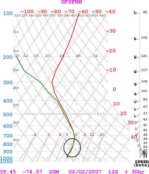
The push of warmth right on the coastline and across Long Island is even more aggressive than for the big cities. By 2/2 12z, cities such as Atlantic City suffer from > 0°C readings through 800 mb. For illustrative purposes, the 30-hour sounding for Atlantic City from the 2/1 6z GFS follows:
As a result of the surge of warmth aloft, the New Jersey Shore and Long Island will see its snowfall hopes damaged by this push of warmer air aloft. There, amounts should generally come under an inch (possibly well under an inch in some locales e.g., Atlantic City).
I do want to note that I believe the 6z GFS was somewhat overdone, both with the qpf and the warm air advection. So, my thinking is a little less aggressive with both. The 12z GFS is coming out and it seems to back off the 6z GFS ideas with respect to qpf, but the soundings are not yet available.
Final Estimates:
Allentown: 2" or less
Baltimore: 2" or less
Boston: 2" or less
Hartford: 1"-3"
Islip: 1" or less
New York City: 1”-3"
Newark: 1"-3"
Philadelphia: 1"-3"
Providence: 2" or less
Washington, DC: 2" or less
Worcester: 2”-5”
Furthermore, light snows were breaking out across the Philadelphia area ahead of the model guidance. However, this might be a signal of a slightly stronger push of warm air that is overrunning the retreating cold air aloft and therefore does not suggest the potential for upward adjustments in total snowfall.
Unfortunately, with the absence of a cold high to the north, it appears that enough warmer air will punch in at the 850 mb-925 mb levels of the atmosphere to trim the already light snowfall ideas I had in mind for some of the big cities from Washington, DC to Boston on account of somewhat more liquid precipitation. All of the big cities should see at least some sleet and rain.
Later, a few of these cities, particularly as one heads north and east of New York City might see some backlash snow or a second area of snow expand eastward later tomorrow and tomorrow night lasting into the first part of Saturday to end the precipitation, after a pause of several hours during which there might be no precipitation at all. The storm’s fast forward motion, as noted in the initial discussion, should rule out sizable backlash snows, even if a comma-head tries to develop as the storm deepens fairly quickly as it pulls away from the offshore waters of New England.
The push of warmth right on the coastline and across Long Island is even more aggressive than for the big cities. By 2/2 12z, cities such as Atlantic City suffer from > 0°C readings through 800 mb. For illustrative purposes, the 30-hour sounding for Atlantic City from the 2/1 6z GFS follows:
As a result of the surge of warmth aloft, the New Jersey Shore and Long Island will see its snowfall hopes damaged by this push of warmer air aloft. There, amounts should generally come under an inch (possibly well under an inch in some locales e.g., Atlantic City).
I do want to note that I believe the 6z GFS was somewhat overdone, both with the qpf and the warm air advection. So, my thinking is a little less aggressive with both. The 12z GFS is coming out and it seems to back off the 6z GFS ideas with respect to qpf, but the soundings are not yet available.
Final Estimates:
Allentown: 2" or less
Baltimore: 2" or less
Boston: 2" or less
Hartford: 1"-3"
Islip: 1" or less
New York City: 1”-3"
Newark: 1"-3"
Philadelphia: 1"-3"
Providence: 2" or less
Washington, DC: 2" or less
Worcester: 2”-5”
0 likes
-
donsutherland1
- S2K Analyst
- Posts: 2718
- Joined: Mon Sep 15, 2003 8:49 pm
- Location: New York
In my post with my final snowfall estimates for the 2/1-2 period, I noted:
Later, a few of these cities, particularly as one heads north and east of New York City might see some backlash snow or a second area of snow expand eastward later tomorrow and tomorrow night lasting into the first part of Saturday to end the precipitation, after a pause of several hours during which there might be no precipitation at all.
Per the 18z guidance, it appears that this second area of snow may well provide the larger accumulations for a number of northern Mid-Atlantic/Northeast cities, particularly from Newark north and eastward. All in all, this is not a good event for snowlovers and I fully expect a number of busts when it comes time to verify my 1/30 and 2/1 estimates for the above timeframe.
0 likes

NC Weather
Don,
You are amazing! You forecast what we had today within an accuracy that the weather people must have been relying on cause we had 1' snow and then a little ice and freezing rain and rain throughout the day but no travel problems to speak of.
Now, What is your predictions for the upcoming 14 days with the first week of Feb first for NC.
You are my weatherman in all seasons~ Amazing!
0 likes
-
Jim Cantore

SE mass and south coastal rhode island got 3-4 inches from the storm last nite early morn take from the public info statement
Massachusetts
... Bristol County...
New Bedford 3.7 830 am 2/2 Skywarn
North Dartmouth 3.7 804 am 2/2 public
Acushnet 3.5 800 am 2/2 spotter
... Plymouth County...
Manomet 2.8 1206 PM 2/2 spotter
Wareham 3.0 800 am 2/2 media
Rhode Island
... Newport County...
Middletown 3.5 1000 am 2/2 spotter
Little Compton 3.0 705 am 2/2 spotter
... Washington County...
South Kingstown 4.3 835 am 2/2 spotter
westerly 4.0 1035 am 2/2 spotter
Narragansett 3.6 945 am 2/2 univ of RI
0 likes
-
donsutherland1
- S2K Analyst
- Posts: 2718
- Joined: Mon Sep 15, 2003 8:49 pm
- Location: New York
Verification:
From January 30, 2007:
Allentown: 1”-2”; Actual: 1.1”; Within range
Baltimore: 1”-3”; Actual: Trace; Error: 1.0”
Boston: 1”-3”; Actual: Trace; Error: 1.0”
Hartford: 1”-3”; Actual: 2.5”; Within range
New York City: 2”-4”; Actual: Trace; Error: 2.0”
Philadelphia: 2”-4”; Actual: 0.2”; Error: 1.8”
Providence: 1”-3”; Actual: 0.2”; Error: 0.8”
Washington, DC: 1”-3”; Actual: Trace; Error: 1.0”
Worcester: 2”-4”; Actual: 2.0”; Within range
From February 1, 2007:
Allentown: 2" or less; Actual: 1.1”; Within range
Baltimore: 2" or less; Actual: Trace; Within range
Boston: 2" or less; Actual: Trace; Within range
Hartford: 1"-3"; Actual: 2.5”; Within range
Islip: 1" or less; Actual: 0.9”; Within range
New York City: 1”-3"; Actual: Trace; Error: 1.0”
Newark: 1"-3"; Actual: Trace; Error: 1.0”
Philadelphia: 1"-3"; Actual: 0.2”; Error: 0.8”
Providence: 2" or less; Actual: 0.2”; Within range
Washington, DC: 2" or less; Actual: Trace; Within range
Worcester: 2”-5”; Actual: 2.0”; Within range
0 likes
Who is online
Users browsing this forum: No registered users and 164 guests