Cirrus Causes Much Warmer than Expected Temps for FL

Winter Weather Discussion

Moderator: S2k Moderators

Forum rules

The posts in this forum are NOT official forecast and should not be used as such. They are just the opinion of the poster and may or may not be backed by sound meteorological data. They are NOT endorsed by any professional institution or STORM2K.

Help Support Storm2K
Message
Author
User avatar
NDG
S2K Supporter
S2K Supporter
Posts: 15446
Joined: Sun Jul 09, 2006 10:14 pm
Location: Orlando, FL

#21 Postby NDG » Wed Jan 31, 2007 8:12 am

Another busted forecasted lows for this time all of FL:

Forecasted Lows:
Image
Image

Actual Lows:
Image

We barely got to the upper 30s in Orlando Monday night, what made think to believe the MOS forecasted lows again for this morning's lows.
Though, The NWS office in Melbourne did adjusted their forecasted lows upward to the lower 40s in the Orlando Area at 10PM when they saw on the gulf sat. pics that the clouds were not ledding up as much as the models were indicating, but still, no where close to the low 40s.
They, including TV mets, should had looked at the 12z raw data, that was indicating temps only in the 40s across all of central FL, instead of the GFS MOS which absolutely busted on Monday night's low temps.
0 likes   

User avatar
AJC3
Admin
Admin
Posts: 3999
Age: 61
Joined: Tue Aug 31, 2004 7:04 pm
Location: Ballston Spa, New York
Contact:

#22 Postby AJC3 » Wed Jan 31, 2007 12:15 pm

A few things to keep in mind...

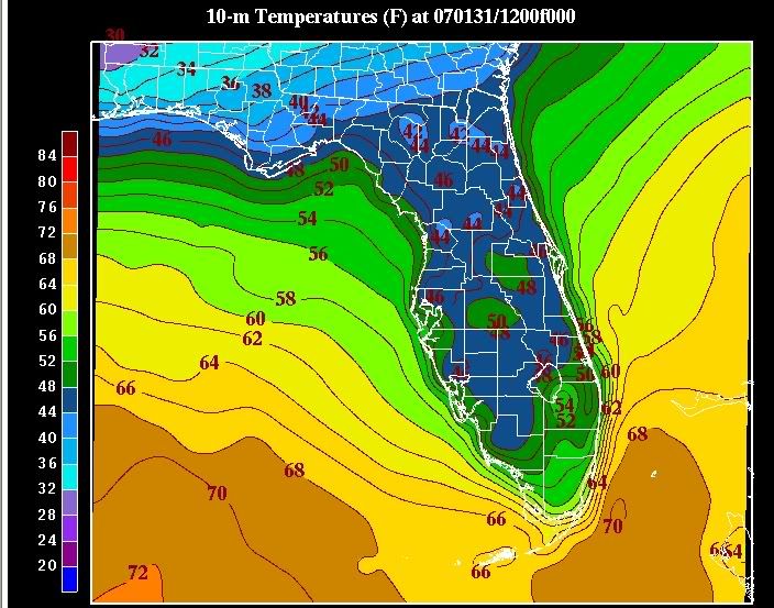
1) When using ADAS "surface analysis", it's important to note that this is actually an interpolation of surface and mesonet data laid on the background field of an initialization panel of the WRF mesomodel.

2) The field is 10-meter temps, not standard 2-meter temps, which are often colder

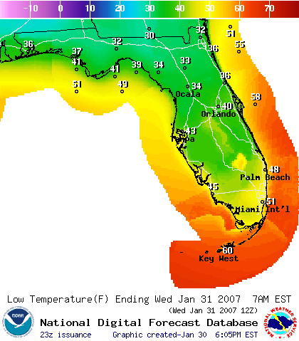
3) While 12 UTC temps are often a good proxy for mins, since mins generally occur right around (or sometimes a little bit after) sunrise, they fail to take into account several factors such as between hour temperature drops, and, obviously situations when the low temperature occurs well before sunrise. Such was the case during both Tuesday and Wednesday mornings.

Granted, the low temperature forecasts were too high on both mornings due to extensive high cloudiness. However, they weren't quite as bad as the graphics would lead one to believe.

For instance, on Tuesday morning, lows in the middle 30s were common throughout almost the entirety of east central Florida - outside of the Metro Orlando area, where temperatures hovered around 40F, and along coastal areas of Martin County (M-U40s), which was where the biggest forecast "bust" occurred.

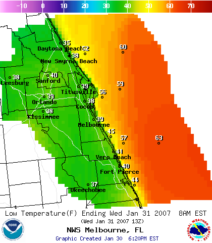
On Wednesday morning, outside of the Orlando urban heat island (46-50F) lows at all the major reporting stations were in the lower 40s (43-44F). Again, higher than originally forecast by about a category (U30s), but not an egregious miss (IMNSHO).

Just some food for thought. Hopefully, this won't be taken as "spin".
0 likes   

User avatar
NDG
S2K Supporter
S2K Supporter
Posts: 15446
Joined: Sun Jul 09, 2006 10:14 pm
Location: Orlando, FL

#23 Postby NDG » Wed Jan 31, 2007 7:54 pm

I understand your your points, and they are good ones. My question is why was GFS's raw data for the forecasted lows, which were more accurate for the last two nights, not taken into consideration, they maybe were, I don't know.
I just realized you work for the NWS in Melbourne, I don't mean to sound disrespectful to your department, you are the guys with a degree in Meteorology, not me. :wink:
0 likes   

wjs3
S2K Supporter
S2K Supporter
Posts: 633
Joined: Sat Aug 14, 2004 7:57 am

#24 Postby wjs3 » Wed Jan 31, 2007 9:02 pm

NDG:

Are you saying that the GFS model grids did a better job than the GFS MOS? Sorry, just want to make sure I understand. I'm learning all this stuff, but I've always understood the raw data can really stink in handling surface temps, with all the complex radiational stuff that goes on...hence the need for MOS.

Also, are you comparing the raw GFS output to the 12z 10 M temps you posted? If so, wouldn't that be a possible source of difference too--per AJC3's note, those 10M temps are bound to be different than the surface temps, right? The GFS output is a 2M temp, not 10M, right?

WJS3
0 likes   

User avatar
NDG
S2K Supporter
S2K Supporter
Posts: 15446
Joined: Sun Jul 09, 2006 10:14 pm
Location: Orlando, FL

#25 Postby NDG » Wed Jan 31, 2007 10:08 pm

WJS3,
Yes, IMO the GFS raw model's 2M temps did better than the GFS's MOS for the last couple of nights. And yes, in my unprofessional experience, I have noticed the raw numbers due stink a lot of times compared to the MOS, it is still not a perfect system either way. And yes, maybe that 10 M map was not the right one to show to make a comparison, I wish I would had found a map that showed 2M temps instead and actual lows, which they don't really occur at the same time from spot to spot.
0 likes   


Return to “Winter Weather”

Who is online

Users browsing this forum: No registered users and 5 guests