It feels, like it's forever
No reason for emptiness
But time just runs away…
— Exposé
Those words could pretty much sum up the seemingly unending reign of unseasonable warmth that has covered much of North America for week after week. It feels like the warmth has been here forever. Snow lovers are left with an empty sense of hopelessness. With each new warm day, the time for winter weather seems to run away. But, as Exposé also added, “Seasons change.”
And so, that’s how the pattern will slowly evolve and the emphasis is on “slowly.” The January blowtorch will likely begin to fade from memory as more seasonable cold returns to a growing part of the nation. Ahead of the timeframe and perhaps its first day could prove quite mild on the immediate East Coast. Toward the end of the timeframe under consideration, Canada could be filling with a large pool of cold air that could be poised to move into the United States soon afterward. At the same time, there is a chance that the Pacific Northwest could be warming.
On a cautionary note, the objective analogs are generally warmer than the ideas based on the GFS ensembles, GSM, and what has happened in the past given the state of the PNA (neutral to moderately positive) and NAO (somewhat positive). Nonetheless, a compromise seems to fit reasonably well with the idea of a gradual pattern change, so we’ll see how that works out.
Considering the spread between the scenario painted by the objective analogs and the forecasts based on the other guidance, there is probably a greater risk of error than with recent developments that were signaled well ahead of time e.g., the ongoing blowtorch that is likely to topple record highs in the East tomorrow. Areas at greatest risk for error are probably the Northern Plains, Pacific Northwest, and Southeast.
However, the coldest air (the kind where temperatures fall below 15° in such cities as Philadelphia) likely won’t arrive until after the January 16-22 timeframe. In short, I believe the 1/5 0z run of the GFS was too cold in the extended range and, even as the 384-hour snowstorm for parts of the East was beautiful to behold for a region that is thirsting for snow, it is not a very likely scenario for the January 16-22 timeframe. I do believe one will begin to see more frequent snows across Northern New England (including Burlington) and southern Quebec and perhaps another Plains States event. An event that sees rain end as snow in the northern Mid-Atlantic and southern New England region is a possibility.
My thinking for the average temperature anomalies during the 1/16-22 period is as follows:
Average Regional Temperature Anomalies (1/16-22):
Northeast: Somewhat below normal to near normal
Mid-Atlantic: Near normal
Southeast: Near normal
Great Lakes: Somewhat below normal
Northern Plains: Somewhat below normal to near normal
Central Plains: Somewhat below normal
Southern Plains: Somewhat below normal
Pacific Northwest: Near normal to somewhat above normal
Southwest/Rest of West Coast: Above normal
For the major cities from Washington, DC to Boston, the 1/16-22 period is likely to feature:
- Nights generally in the 20s and 30s, especially from Philadelphia to Boston
- Days mainly in the 30s and 40s in Philadelphia, New York City, and Boston and 40s in Washington, DC.
- One or more days with a high temperature of 50° is possible in Washington, DC and Philadelphia.
In the Southeast, Atlanta will likely see highs generally in the 50s and 60s. Lows should generally be in the 30s and 40s. Burlington will likely see highs mainly in the 20s and 30s. Lows should be in the teens and 20s.
January 16-22, 2007 Idea: Seasons Change
Moderator: S2k Moderators
Forum rules
 The posts in this forum are NOT official forecast and should not be used as such. They are just the opinion of the poster and may or may not be backed by sound meteorological data. They are NOT endorsed by any professional institution or STORM2K.

The posts in this forum are NOT official forecast and should not be used as such. They are just the opinion of the poster and may or may not be backed by sound meteorological data. They are NOT endorsed by any professional institution or STORM2K.
-
donsutherland1
- S2K Analyst

- Posts: 2718
- Joined: Mon Sep 15, 2003 8:49 pm
- Location: New York
-
JonathanBelles
- Professional-Met

- Posts: 11430
- Age: 35
- Joined: Sat Dec 24, 2005 9:00 pm
- Location: School: Florida State University (Tallahassee, FL) Home: St. Petersburg, Florida
- Contact:
-
cycloneye

- Admin

- Posts: 149730
- Age: 69
- Joined: Thu Oct 10, 2002 10:54 am
- Location: San Juan, Puerto Rico
Finnally the real winter will appear in the U.S.As always don,a complete summary of what to expect around the third week of January.
0 likes
Visit the Caribbean-Central America Weather Thread where you can find at first post web cams,radars
and observations from Caribbean basin members Click Here
and observations from Caribbean basin members Click Here


-
donsutherland1
- S2K Analyst
- Posts: 2718
- Joined: Mon Sep 15, 2003 8:49 pm
- Location: New York
From back in December, it appeared to me that a pattern change would likely commence in the January 10-20 timeframe. Now, the evidence overwhelmingly supports just such a change.
-The GFS ensembles have consistently pointed to a persistently colder regime setting in around January 15 +/- 1-2 days.
-The CDC and NCEP ensembles suggest that the EPO will go negative starting tomorrow.
-The super long-duration AO+ regime will likely end before January 20.
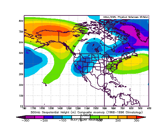
If one examines the NCEP ensemble 500 mb height anomalies forecast for 312 hours, one finds a synoptic setup over North America that tends to resemble the January 30, 1951 arrangement.
NCEP Ensemble 500 mb Height Anomalies (312 hours):

500 mb Height Anomalies (January 30, 1951):
During the January 30-February 10, 1951 timeframe, several cold shots affected the East. The lowest temperature recorded during that timeframe for select cities follows:
Atlanta: 8°
Boston: 1°
Burlington: -21°
New York City: 11°
Philadelphia: 12°
Richmond: 10°
Washington, DC (DCA): 11°
It should be noted that the area of monthly cold anomalies for November and December 1950 was much more extensive than that for the same months in 2006. As a result, I don’t believe one will see cold this month that rivals that in such cities as Atlanta, Boston, and Burlington.
Nonetheless, consistent with my thinking, concerning the timing of more significant cold, the closing 8-10 days of January have the potential to see low temperatures fall into the teens well into the Mid-Atlantic states (15° or below for such cities as Philadelphia northward) on one or more days. From Washington, DC northward, there will likely be several days with highs staying below 32°. Burlington may see one or more subzero lows during that timeframe. Boston could see the temperature approach or fall below 10° on at least one day. In short, the long-heralded and even more anxiously-awaited pattern change now appears imminent.
-The GFS ensembles have consistently pointed to a persistently colder regime setting in around January 15 +/- 1-2 days.
-The CDC and NCEP ensembles suggest that the EPO will go negative starting tomorrow.
-The super long-duration AO+ regime will likely end before January 20.
If one examines the NCEP ensemble 500 mb height anomalies forecast for 312 hours, one finds a synoptic setup over North America that tends to resemble the January 30, 1951 arrangement.
NCEP Ensemble 500 mb Height Anomalies (312 hours):
500 mb Height Anomalies (January 30, 1951):
During the January 30-February 10, 1951 timeframe, several cold shots affected the East. The lowest temperature recorded during that timeframe for select cities follows:
Atlanta: 8°
Boston: 1°
Burlington: -21°
New York City: 11°
Philadelphia: 12°
Richmond: 10°
Washington, DC (DCA): 11°
It should be noted that the area of monthly cold anomalies for November and December 1950 was much more extensive than that for the same months in 2006. As a result, I don’t believe one will see cold this month that rivals that in such cities as Atlanta, Boston, and Burlington.
Nonetheless, consistent with my thinking, concerning the timing of more significant cold, the closing 8-10 days of January have the potential to see low temperatures fall into the teens well into the Mid-Atlantic states (15° or below for such cities as Philadelphia northward) on one or more days. From Washington, DC northward, there will likely be several days with highs staying below 32°. Burlington may see one or more subzero lows during that timeframe. Boston could see the temperature approach or fall below 10° on at least one day. In short, the long-heralded and even more anxiously-awaited pattern change now appears imminent.
0 likes


January 30-February 10, 1951
Hi, Don:
I was researching earlier and found out that the above period coincided with a particularly nasty streak of weather around Houston. 132 consecutive hours without going above freezing, and also a significant ice storm that ran from there all the way to Philly with accumulations of up to 4 inches.
How close of a repeat are we in for?
0 likes

-
donsutherland1
- S2K Analyst
- Posts: 2718
- Joined: Mon Sep 15, 2003 8:49 pm
- Location: New York
-
donsutherland1
- S2K Analyst
- Posts: 2718
- Joined: Mon Sep 15, 2003 8:49 pm
- Location: New York
-
donsutherland1
- S2K Analyst
- Posts: 2718
- Joined: Mon Sep 15, 2003 8:49 pm
- Location: New York
Just some quick thoughts...
- The long-anticipated pattern change is now unfolding. Since Midnight, the temperature has fallen 20° in NYC, 18° in PHL and DCA, and 17° at EWR. Readings will continue to fall through the afternoon into the evening.
- Initially, the generally colder regime will be fairly dry with systems sailing to the south and east of the Mid-Atlantic states. Parts of this region can be clipped with light snow
- A more active subtropical jet will be bringing more meaningful systems across the southern tier of the USA beginning around 1/30 +/- a few days
So far, the GFS ensembles have performed magnificently in recent weeks with respect to several blowtorch episodes and the now unfolding pattern change. As they have consistently tracked the 1/19 system to the east of that depicted by the 1/16 12z NAM, I don't have a great deal of confidence in the NAM's more robust in-close solution.
Moreover, as the pattern continues to head toward one that was reasonably similar to the 1/30/1951 pattern around 1/22, I also have added confidence that snowfall amounts over the next several days will prove modest (except for eastern New England/northern New England where moderate amounts are possible).
All said, my initial thinking concerning the 1/19 event is as follows:
Boston: 1"-3" (possibly a little more)
New York City: <1"
Philadelphia: Little if any accumulation
Providence: 1"-2"
There is a chance that PHL, EWR, and NYC could see no measurable snowfall. From Suffolk County south and westward, including the central Jersey shore southward, some rain might well mix with any snow. Behind the intensifying offshore storm, strong winds will usher in another shot of cold air.
0 likes
-
donsutherland1
- S2K Analyst
- Posts: 2718
- Joined: Mon Sep 15, 2003 8:49 pm
- Location: New York
My final thoughts on the 1/18-19 event are as follows:
Boston: < 2"
New York City: <1"
Philadelphia: <1"
Providence: <2"
There is a chance that PHL, EWR, and NYC could see no measurable snowfall. Rain will also occur in each of these cities.
Looking ahead, the 1/21-22 event, I don't believe it will be a significant storm. It might bring a light accumulation to the Washington, DC metro area and northern Virginia. Later, it could bring some snow to eastern New England. Again, cities such as Philadelphia and New York will likely see little if any precipitation.
0 likes
-
wx247

- S2K Supporter

- Posts: 14279
- Age: 42
- Joined: Wed Feb 05, 2003 10:35 pm
- Location: Monett, Missouri
- Contact:
Don...what are your thoughts on the snow for the Southern Plains this weekend? I know that the East is your primary area of emphasis but I can't get a good read on it. We have been in and out of power and mom has been without for several days. A good snowstorm may setback the power restoration.
0 likes
Personal Forecast Disclaimer:
The posts in this forum are NOT official forecast and should not be used as such. They are just the opinion of the poster and may or may not be backed by sound meteorological data. They are NOT endorsed by any professional institution or storm2k.org. For official information, please refer to the NHC and NWS products.
The posts in this forum are NOT official forecast and should not be used as such. They are just the opinion of the poster and may or may not be backed by sound meteorological data. They are NOT endorsed by any professional institution or storm2k.org. For official information, please refer to the NHC and NWS products.
-
donsutherland1
- S2K Analyst
- Posts: 2718
- Joined: Mon Sep 15, 2003 8:49 pm
- Location: New York
-
Lowpressure

- S2K Supporter
- Posts: 2032
- Age: 59
- Joined: Sun Sep 14, 2003 9:17 am
- Location: Charlotte, North Carolina
-
donsutherland1
- S2K Analyst
- Posts: 2718
- Joined: Mon Sep 15, 2003 8:49 pm
- Location: New York
Verification of 1/18-19 Snowfall Estimates:
From 1/16:
Boston: 1"-3" (possibly a little more); Actual: Trace; Error: 1"
New York City: <1"; Actual: 0.3"; Within range
Philadelphia: Little if any accumulation; Actual: 0.1"; Error: 0.1"
Providence: 1"-2"; Actual: Trace: Error: 1"
From 1/18:
Boston: < 2"; Actual: Trace; Within range
New York City: <1"; Actual: 0.3"; Within range
Philadelphia: <1"; Actual: 0.1"; Within range
Providence: <2"; Actual: Trace; Within range
0 likes
-
donsutherland1
- S2K Analyst
- Posts: 2718
- Joined: Mon Sep 15, 2003 8:49 pm
- Location: New York
Lowpressure,
At this time, I'm thinking that on account of a push of colder air/potential for some cold air damming, the Charlotte area could experience an extended period of sleet and/or freezing rain before the precipitation transitions to rain. Raleigh will probably see perhaps a little ice at the start before going over to rain.
At this time, I'm thinking that on account of a push of colder air/potential for some cold air damming, the Charlotte area could experience an extended period of sleet and/or freezing rain before the precipitation transitions to rain. Raleigh will probably see perhaps a little ice at the start before going over to rain.
0 likes
-
Lowpressure
- S2K Supporter
- Posts: 2032
- Age: 59
- Joined: Sun Sep 14, 2003 9:17 am
- Location: Charlotte, North Carolina
Don, thanks for the post. Are you talking about Sunday? If so, that aligns well with the current forecast of borderline Winter Storm Watch criteria north of I-85 and I-40. I was actually more talking in to the longer range of Jan 28th onward. The 2nd through the 4th particularly.
Great work so far and quite accurate during a rather difficult to predict winter.
Great work so far and quite accurate during a rather difficult to predict winter.
0 likes
Who is online
Users browsing this forum: No registered users and 116 guests