NWS Charlotte forecasting light snow/ wintery mix based on location for Thursday possibly into Thursday evening for a good chunk of the CWFA.
Not expected to be much at this point, but a taste of long awaited winter at last. Middle of next week starting to look promising for this area again-winter wise. Please feel free to chime in on this.
Finally, some winter coming to the Carolinas
Moderator: S2k Moderators
Forum rules
 The posts in this forum are NOT official forecast and should not be used as such. They are just the opinion of the poster and may or may not be backed by sound meteorological data. They are NOT endorsed by any professional institution or STORM2K.

The posts in this forum are NOT official forecast and should not be used as such. They are just the opinion of the poster and may or may not be backed by sound meteorological data. They are NOT endorsed by any professional institution or STORM2K.
-
Lowpressure

- S2K Supporter

- Posts: 2032
- Age: 59
- Joined: Sun Sep 14, 2003 9:17 am
- Location: Charlotte, North Carolina
-
brunota2003

- S2K Supporter
- Posts: 9476
- Age: 35
- Joined: Sat Jul 30, 2005 9:56 pm
- Location: Stanton, KY...formerly Havelock, NC
- Contact:
-
donsutherland1
- S2K Analyst

- Posts: 2718
- Joined: Mon Sep 15, 2003 8:49 pm
- Location: New York
Re: Finally, some winter coming to the Carolinas
Lowpressure,
The forecast soundings are cold enough for some frozen precipitation at the onset and continuing into late morning/early afternoon on Thursday in the Charlotte Metro area.
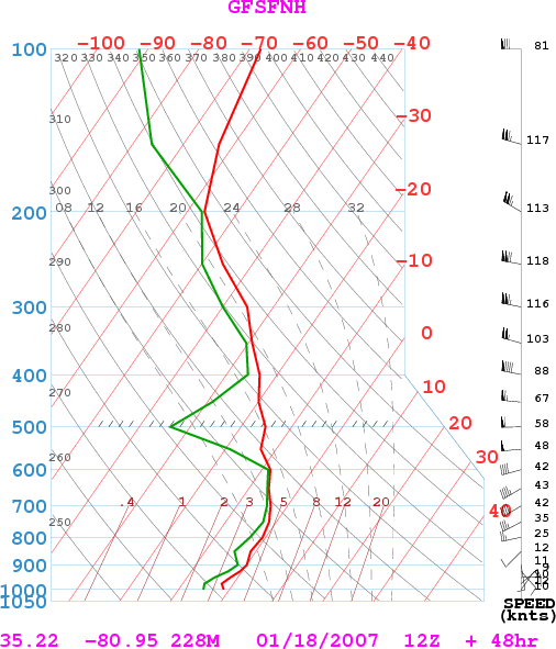
The forecast soundings are cold enough for some frozen precipitation at the onset and continuing into late morning/early afternoon on Thursday in the Charlotte Metro area.
0 likes
-
txwatcher91
- Category 5

- Posts: 1498
- Joined: Tue Aug 02, 2005 2:29 pm
cpdaman wrote:i would keep a close eye on that batch of moisture in louisiana now that should be headed ene and could give the deep south a icing even TONITE and tommorrow in alabama georgia and the carolinas late tommorrow.
Looks possible. Models are not picking up on the area of precip stretching from Louisiana to Georgia, and it is not losing intensity as it heads towards SC and NC. We will have to wait and see what happens with this. It would be a surprise for many people if it actually produced ice/snow for GA, SC, or NC. Here is the radar loop
0 likes
-
txwatcher91
- Category 5
- Posts: 1498
- Joined: Tue Aug 02, 2005 2:29 pm
-
Lowpressure
- S2K Supporter
- Posts: 2032
- Age: 59
- Joined: Sun Sep 14, 2003 9:17 am
- Location: Charlotte, North Carolina
-
Wannabewxman79
- Tropical Storm

- Posts: 181
- Joined: Wed Sep 17, 2003 12:53 pm
- Location: Riegelwood, NC (20 miles W of Wilmington)
Houston
Nothing for us here at the coast as usual. I mean Houston freaking Texas is getting snow and ice but us well north of them won't get any. I think we really have a snow shield on us around here.
0 likes
-
Lowpressure
- S2K Supporter
- Posts: 2032
- Age: 59
- Joined: Sun Sep 14, 2003 9:17 am
- Location: Charlotte, North Carolina
-
Lowpressure
- S2K Supporter
- Posts: 2032
- Age: 59
- Joined: Sun Sep 14, 2003 9:17 am
- Location: Charlotte, North Carolina
-
brunota2003
- S2K Supporter
- Posts: 9476
- Age: 35
- Joined: Sat Jul 30, 2005 9:56 pm
- Location: Stanton, KY...formerly Havelock, NC
- Contact:
They are talking about a "possibly" of ice here as well, but only for a brief period:
AREA FORECAST DISCUSSION
NATIONAL WEATHER SERVICE NEWPORT/MOREHEAD CITY NC
359 AM EST WED JAN 17 2007
.SHORT TERM /TODAY THROUGH FRIDAY/...COLD/DRY ADVECTION CONTS ACROSS
THE REGION EARLY THIS MORN. SHLD SEE CLOUDS DISSIPATE FROM NW TO SE
THROUGH 12Z WITH MOSTLY SUNNY SKIES TODAY. HIGH WILL STRUGGLE TO GET
MUCH ABOVE 45. MDLS CONT TO SHOW LOW PRES DEVELOPING ON CSTL TRF
LATER TONIGHT AND THU. MOISTURE RETURNS RAPIDLY LATE
TONIGHT...EXPECT LOWS IN THE LOWER 30S INLAND TO AROUND 40 OR SO
OBX. PRECIP SHLD BEGIN TO DEVELOP LATE SRN AND ERN SECTIONS AND KEPT
20/30 POPS THESE REGIONS. TEMPS WILL BE JUST ABOVE FREEZING AS
PRECIP BEGINS DEEP INLAND...FOR NOW KEPT PRECIP AS ALL RAIN...STILL
SLIGHT CHC A FEW SPOTS COULD GET VERY BRIEF PD OF FREEZING RAIN BUT
NOT SIGNIFICANT ENUF TO MENTION. RAIN WILL OVERSPREAD REGION THU AS
WEAK LOW MOVES NE TOWARD CST. SHLD BE DECENT TEMP GRDNT WITH MID 40S
DEEP INLAND TO MID/UPR 50S OBX WHERE CSTL TRF MAY SHIFT INLAND. RAIN
WILL GRADUALLY TAPER OFF FROM W TO E THU NIGHT INTO FRI MORN AS LOW
AND DEEPER MOISTURE LIFT TO THE NE. KEPT SLIGHT POP FRI MORN NE
SECTIONS OTHERWISE DRY WITH HIGHS IN THE LOW TO MID 50S.
0 likes
-
Lowpressure
- S2K Supporter
- Posts: 2032
- Age: 59
- Joined: Sun Sep 14, 2003 9:17 am
- Location: Charlotte, North Carolina
-
brunota2003
- S2K Supporter
- Posts: 9476
- Age: 35
- Joined: Sat Jul 30, 2005 9:56 pm
- Location: Stanton, KY...formerly Havelock, NC
- Contact:
Now this is better for winter precip, however I prefer snow over ice. Possible MAJOR bust forcast tonight into tomorrow, and things should be interesting. For southern coastal NC (Wilmington area) there are Winter Wx Advisories hoisted until 10 AM. Nothing for us, yet. Now, for the big bust, would that be in terms of snow/ice accumulation being higher? or only rain? temps here are already hovering around 40 and dropping.
EDIT: Today we were supposed to have a high of 45, only hit 40, current temps of 39. Tonight is going to be very interesting.
SHORT TERM /TONIGHT THROUGH SATURDAY NIGHT/...THIS FORECAST HAS
SIGNIFICANT BUST POTENTIAL FOR TONIGHT SO UP FRONT MUST SAY I HAVE
LOW CONFIDENCE GOING IN. DRY LOW LVL AIRMASS HAS SETTLED OVER THE
CWA TODAY WITH DEW POINTS MAINLY IN THE TEENS INLAND TO 20S ALONG
THE COAST. THIS BECOMES CRITICAL AS PCPN BEGINS TO DEVELOP LATE
TONIGHT. NAM IS A BIT MORE AGGRESSIVE WITH SPREADING PCPN INTO THE
RGN EARLIER THAN THE GFS AND GFS IS A BIT WARMER AS WELL. INITIAL
THINKING WAS TO HOLD OFF ON PCPN UNTIL TOMORROW BUT WITH COASTAL
TROF AND LOW TRYING TO DVLP LATE TONIGHT AND MID LVL OVER
SPREADING THE RGN AFTER MIDNIGHT HAVE OPTED TO GO A BIT CLOSER TO
NAM SOLUTION FOR TONIGHT. ONSET OF PCPN WILL TAKE SOME TIME THOUGH
AS LOW LVLS HAVE TO MOISTEN. THIS SHOULD ALLOW TEMPS TO DROP AS
WELL DUE TO EVAPORATIVE COOLING. LIKELY THAT SFC TEMPS WILL DROP
TO NEAR OR JUST BELOW FREEZING DEEP INLAND LATE TONIGHT AS NAM SFC
WET BULB TEMPS ARE FORECAST TO BE JUST BELOW FREEZING. THIS SHOULD
LEAD TO VERY BRIEF PERIOD OF LIGHT FREEZING RAIN DEEP INLAND
BEFORE SUNRISE. WHILE LITTLE ACCUMULATION IS EXPECTED DO FEEL THAT
A LIGHT GLAZE IS POSSIBLE ON BRIDGES AND OVERPASSES AND SOME
ELEVATED SFCS BEFORE SUNRISE ACROSS DUPLIN...LENOIR AND GREENE
COUNTIES. ANY OTHER AREAS THAT GET PCPN LATE TONIGHT SHOULD BE
WARM ENOUGH FOR ONLY RAIN AND ONCE THE SUN RISES TOMORROW TEMPS
SHOULD WARM ENOUGH FOR ONLY RAIN.
NOW COMES ANOTHER PROBLEM...HIGHS TOMORROW. GFS TRIES TO BACK
COASTAL TROF FAIRLY FAR INLAND BUT NOT SO SURE THAT IS GOING TO
HAPPEN. HIGHS INLAND SHOULD STRUGGLE INTO THE 40S BUT ALONG THE
OBX HIGHS COULD REACH THE MID 50S IF COASTAL TROF BACKS UP AFR
ENOUGH. EXPECT RAIN THROUGH MUCH OF THE DAY AS COASTAL SYSTEM GETS
CRANKED UP BUT WITH STRONG HIGH TO THE NORTH QPF INLAND SHOULD BE
LIMITED. WOULD NOT BE SURPRISED TO SEE TEMPS 5 TO 10 DEGREES LOWER
THAN FORECAST WILL INDICATE FOR TOMORROW.
COLD AIR ADVECTION AND DRYING FOR THURSDAY NIGHT WITH LINGERING PCPN
ALONG THE COAST ENDING BY EARLY FRIDAY MORNING. THEN A PERIOD OF
DRY WEATHER BEGINNING FRIDAY DURING THE DAY WITH SOME WARMING TO
NEAR SEASONAL TEMPS BY SATURDAY AFTN AS HIGH BUILDS TO THE NORTH.
EDIT: Today we were supposed to have a high of 45, only hit 40, current temps of 39. Tonight is going to be very interesting.
0 likes
-
Lowpressure
- S2K Supporter
- Posts: 2032
- Age: 59
- Joined: Sun Sep 14, 2003 9:17 am
- Location: Charlotte, North Carolina
-
Stormsfury

- Category 5
- Posts: 10549
- Age: 53
- Joined: Wed Feb 05, 2003 6:27 pm
- Location: Summerville, SC
Freezing Rain Advisories remain for most of the Charleston CWA ... and after a long wait, KCHS issued the afternoon AFD and it was worth the wait ... one of the better one's they've written ...
AREA FORECAST DISCUSSION
NATIONAL WEATHER SERVICE CHARLESTON SC
535 PM EST WED JAN 17 2007
...WINTER PRECIP TO OCCUR LATE TONIGHT/THU MORNING WELL INLAND...
...GALE WARNING STILL IN EFFECT ACROSS THE OUTER GA WATERS...
.SHORT TERM /TONIGHT THRU THU NIGHT/...VERY COMPLEX WX SITUATION FOR
LATE TONIGHT/EARLY THU. STILL LOOKS LIKE FREEZING RAIN WILL OCCUR
AND WILL KEEP THE FREEZING RAIN ADVISORY GOING FOR SEVERAL INLAND
COUNTIES.
HAVE DECIDED TO KEEP TOTAL ICE ACCUMULATIONS JUST BELOW WARNING
CRITERIA /ONE QUARTER INCH/ SINCE RAIN WILL BE MIXED IN AT TIMES
HOLDING DOWN ICE ACCUMULATIONS. STILL...WILL KEEP UP TO 2/10 INCH OF
ICE ACCUMULATIONS GOING IN THE FCST. MUCH OF THAT WILL BE ON HIGHER
ELEVATIONS SUCH AS BRIDGES AND OVERPASSES...TREETOPS AND POWERLINES.
BECAUSE GROUND TEMPS ARE SO WARM...NOT AS MUCH ICING IS ANTICIPATED
ON ROADS...WALKWAYS AND GRASSY SURFACES.
ALTHOUGH MODELS ARE SUGGESTING THAT IT WILL BE MARGINAL FOR THIS
ICING EVENT...I AM EXTREMELY CONCERNED THAT WET BULBS WILL BE LOWER
THAN SUGGESTED AND THAT THERE IS JUST ENOUGH OF A COLD SUB-FREEZING
LAYER UP TO ABOUT 500 FT FOR THE RAIN TO FREEZE. CLIMATOLOGICALLY
THE WEDGE IS STRONGER AND HOLDS ONTO THE COLD AIR LONGER THAN THE
MODELS WOULD SUGGEST...THUS CONFIDENCE IS FAIRLY GOOD ON ICING
PROBLEMS.
THE BOUNDARY LAYER IS GOING TO TAKE SOME TIME TO MOISTEN UP
TONIGHT...WITH DEWPT DEPRESSIONS STILL CLOSE TO 20 DEGREES IN MANY
AREAS. THUS I HAVE BACKED OFF ON THE START TIME OF THE RAIN UNTIL
NEAR OR AFTER MIDNIGHT...AND THE EVE SHIFT MAY NEED TO DELAY THE
START OF THE FREEZING PRECIP AND ACCOMPANYING ADVISORY UNTIL CLOSER
TO DAYBREAK.
LOWS TONIGHT WILL BE DOWN NEAR FREEZING IN SOME AREAS INLAND...MID
TO UPPER 30S CLOSER TO THE COAST...WITH A FEW READINGS NEAR 40 ALONG
THE IMMEDIATE SHORELINE. WILL BE HARD-PRESSED TO GET OUT OF THE 30S
IN A FEW FAR INLAND SECTIONS THU AS NLY WINDS AND PRECIP DO NOT
ALLOW FOR MUCH RISE IN TEMPS.
THE COASTAL TROUGH WILL GRADUALLY SHIFT AWAY FROM THE AREA LATE THU
INTO THU NIGHT...AND THIS WILL ALLOW FOR DECREASING PRECIP CHANCES.
HOWEVER...EXTREMELY LOW INVERSION AND PLENTY OF MOISTURE WILL LINGER
DURING THIS TIME...SO LOOKING AT SOME LEFTOVER DRIZZLE INTO THU
NIGHT...WITH ONLY A SMALL DECREASE IN NIGHT TIME TEMPS.
&&
0 likes
-
txwatcher91
- Category 5
- Posts: 1498
- Joined: Tue Aug 02, 2005 2:29 pm
-
Eyes2theSkies

- Category 1

- Posts: 264
- Joined: Thu Aug 12, 2004 4:20 am
- Location: Was Florida now Charlotte, NC
- Contact:
-
Wannabewxman79
- Tropical Storm
- Posts: 181
- Joined: Wed Sep 17, 2003 12:53 pm
- Location: Riegelwood, NC (20 miles W of Wilmington)
-
Lowpressure
- S2K Supporter
- Posts: 2032
- Age: 59
- Joined: Sun Sep 14, 2003 9:17 am
- Location: Charlotte, North Carolina
-
Eyes2theSkies
- Category 1
- Posts: 264
- Joined: Thu Aug 12, 2004 4:20 am
- Location: Was Florida now Charlotte, NC
- Contact:
Who is online
Users browsing this forum: No registered users and 93 guests