The December AO: An Ominous Signal

Winter Weather Discussion

Moderator: S2k Moderators

Forum rules

The posts in this forum are NOT official forecast and should not be used as such. They are just the opinion of the poster and may or may not be backed by sound meteorological data. They are NOT endorsed by any professional institution or STORM2K.

Help Support Storm2K
Message
Author
JBG
Tropical Storm
Tropical Storm
Posts: 146
Joined: Fri Apr 29, 2005 12:34 pm
Location: New York City area
Contact:

#41 Postby JBG » Sun Dec 31, 2006 1:11 pm

donsutherland1 wrote:JBG,

For one thing, there was virtually no blocking from late January until near mid-March in 1972-73. That does not appear likely this time around.


The one snow that NYC did get that winter over 1", that is on January 29, 1973, was not "blocking-related"?
0 likes   

User avatar
R-Dub
Category 5
Category 5
Posts: 1427
Joined: Thu Dec 30, 2004 2:18 pm
Location: Stanwood, WA
Contact:

#42 Postby R-Dub » Mon Jan 01, 2007 2:00 pm

I am not an expert of the AO, would the very high AO account for the wild wicked weather the northwest has experienced over the last few months? Its been the most memorable winter of my 30yrs of life! The early November Pineapple Express that caused many rivers in WA state to rise to there highest levels ever on record. Then there was the major arctic outbreak that happened at the end of November. I recieved 14" of snow, and had low temps down into the single digits which is very rare here in western WA and to have it happen in November was wild. Then came the biggest windstorm to slam our area since the Columbus day windstorm of 1962. In between those major events we have had consistant below normal temps (which has meant perfect snow conditions in the ski areas. Many of the ski resorts have over 100" base) Also have had many thunder storms and mini weather events. It has been a wild ride here in the Northwest!! No where near a normal El Nino year where we usually have quiet, mild, drier winters. Oh and there is flood watches out for many of our rivers once again starting tomorrow. All i can say is WOW, what a winter season!
0 likes   

User avatar
wxmann_91
Category 5
Category 5
Posts: 8013
Age: 34
Joined: Fri Jul 15, 2005 2:49 pm
Location: Southern California
Contact:

#43 Postby wxmann_91 » Mon Jan 01, 2007 9:04 pm

R-Dub wrote:I am not an expert of the AO, would the very high AO account for the wild wicked weather the northwest has experienced over the last few months? Its been the most memorable winter of my 30yrs of life! The early November Pineapple Express that caused many rivers in WA state to rise to there highest levels ever on record. Then there was the major arctic outbreak that happened at the end of November. I recieved 14" of snow, and had low temps down into the single digits which is very rare here in western WA and to have it happen in November was wild. Then came the biggest windstorm to slam our area since the Columbus day windstorm of 1962. In between those major events we have had consistant below normal temps (which has meant perfect snow conditions in the ski areas. Many of the ski resorts have over 100" base) Also have had many thunder storms and mini weather events. It has been a wild ride here in the Northwest!! No where near a normal El Nino year where we usually have quiet, mild, drier winters. Oh and there is flood watches out for many of our rivers once again starting tomorrow. All i can say is WOW, what a winter season!

I'm not Don, and I'm no expert, but I believe it may have played a role by enhancing the Pacific jet stream, sending rounds and rounds of storms into the Pacific Northwest. This jet stream has been unusually strong and has overrided the effects of El Nino. The jet stream is the result of a strong polar vortex at the Bering Sea (thus creating very cold conditions in Alaska and eastern Russia), and that polar vortex could've been a byproduct of the +AO.
0 likes   

donsutherland1
S2K Analyst
S2K Analyst
Posts: 2718
Joined: Mon Sep 15, 2003 8:49 pm
Location: New York

#44 Postby donsutherland1 » Wed Jan 03, 2007 8:43 am

In multiple places in this thread, it has been noted that the demise of super long-duration AO+ regimes has often been followed by periods of frequent blocking. As the current 39-day event approaches its flip to negative in the January 10-20 timeframe, the NCEP ensemble mean 500 mb anomalies are showing that such blockiness is likely to occur consistent with historic experience.

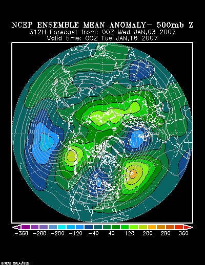
If one examines the animation of hours 312 through 360, one finds:

1. A dramatic collapse of the below to much-below normal height anomalies as they head into Europe.
2. The increase in above normal height anomalies across the North Atlantic
3. The possible departure of an area of above to much-above normal height anomalies from the vicinity of Newfoundland possibly toward the vicinity of Greenland or Europe.

Image

That third point is particularly intriguing. It bears watching, as it may pave the road for a longer, stronger episode of blocking. On 12/29 I described how such an evolution has occurred in two notable occasions. Those excerpts follow:

Here’s how such a situation has evolved in the past:

• An area of above to much above normal height of anomalies has moved off North America in the vicinity of Newfoundland (sometimes slowly, but sometimes more quickly).
• 2-4 days later that area was centered south of Iceland.
• 2-4 days later that area grew elongated (sometimes stretching from Europe to or across much of North America i.e., January 1958 and February 1962)
• From that it either continued to head for Europe where it often transitioned into a Scandanavian block that then retrograded or took a “short-cut” toward Iceland and from there retrograded.

During this evolution of events, one saw the area of above normal height anomalies periodically go through pulses of amplification and de-amplification. Later, the block remained in a semi-permanent position. In 1958, that block was largely centered in the vicinity of the Davis Strait from where it drifted, sometimes to the Hudson Bay area. In 1962, the block reached Scandanavia then very slowly retrograded across Greenland to the Davis Strait. That process consumed 6 days after the a 12-day “elongated” phase. Afterward, it took up a semi-permanent residence in the vicinity of the Davis Strait, while drifting somewhat as happened in 1958.


In terms of sensible weather, my position from that post unchanged:

one should not assume that it will translate into an Arctic blast for the East. It will probably come east and reach the East Coast near January 15 +/- 2 days and bring a shot of meaningful cold. Nonetheless, if historic experience holds up, its lowest temperatures probably won’t fall below 15° in either New York City or Philadelphia. The following snippet from earlier in this thread sums up this situation reasonably well:

...readings will merely trend to normal with occasional periods of somewhat below normal cold following the fall of the AO+ regime. More significant cold in which one or more days could see readings fall below 15° in New York City and Philadelphia might not reach the East for 10-14 days after the AO flips to negative.

Having said this, a temperature regime that is closer to normal will begin to be established in the East. There remains a chance at one additional blowtorch effort before February. However, if such a situation arises, it will likely be brief. As the month advances, the synoptic framework for more sustained and significant cold will continue to evolve.


All said, the timing of the AO's turn to negative and pattern change remain on track. Consistent with historic experience following the demise of super long-duration AO+ regimes, the ensemble guidance is now showing a better environment for more frequent blocking.
0 likes   

JBG
Tropical Storm
Tropical Storm
Posts: 146
Joined: Fri Apr 29, 2005 12:34 pm
Location: New York City area
Contact:

#45 Postby JBG » Wed Jan 03, 2007 9:10 am

The question is, why wouldn't this repeat the 2001-2 pattern of a plunge into blocking, followed by a fast return to positive AO conditions? (aside for the fact that we're all "winter weather" freaks)?
0 likes   

donsutherland1
S2K Analyst
S2K Analyst
Posts: 2718
Joined: Mon Sep 15, 2003 8:49 pm
Location: New York

#46 Postby donsutherland1 » Wed Jan 03, 2007 9:35 am

JBG,

Unlike 2001-02, there does not appear to be any indication of severe blocking during a time which Canada was filled with unseasonably warm air. Instead, a more gradual development of blocking appears likely and with the AO being negative for some time, Canada should have a much better supply of colder air. Unlike 2001-02, it appears that there is a chance for a prolonged period of blocking later this month, but that's not yet assured.

ENSO climatology also suggests a different outcome.
0 likes   

JBG
Tropical Storm
Tropical Storm
Posts: 146
Joined: Fri Apr 29, 2005 12:34 pm
Location: New York City area
Contact:

#47 Postby JBG » Wed Jan 03, 2007 7:32 pm

donsutherland1 wrote:JBG,

Unlike 2001-02, there does not appear to be any indication of severe blocking during a time which Canada was filled with unseasonably warm air. Instead, a more gradual development of blocking appears likely and with the AO being negative for some time, Canada should have a much better supply of colder air. Unlike 2001-02, it appears that there is a chance for a prolonged period of blocking later this month, but that's not yet assured.

ENSO climatology also suggests a different outcome.


Thanks. Jim
0 likes   

bkster7
Tropical Wave
Tropical Wave
Posts: 2
Joined: Thu Jan 04, 2007 10:16 pm
Location: Charlotte, NC

#48 Postby bkster7 » Thu Jan 04, 2007 10:33 pm

I have enjoyed reading this discussion on the AO. It is very interesting. Have a question I hope one of you can answer. With the weather being so warm there is lots of talk on the news about Global Warming. Is the prolong postive AO cycle a result of conditions that are caused by global warming or is it just cycles that the AO goes through and has nothing to do with global warming. thanks
0 likes   

donsutherland1
S2K Analyst
S2K Analyst
Posts: 2718
Joined: Mon Sep 15, 2003 8:49 pm
Location: New York

#49 Postby donsutherland1 » Thu Jan 04, 2007 11:41 pm

Bkster7,

Unfortunately, I don't yet have sufficient information as to whether global warming has been contributing to a tendency for more positive AO setups. There have been longer AO+ regimes than the current one. In 1951-52, the AO remained positive for 58 consecutive days. We're currently at 40 days.
0 likes   

JBG
Tropical Storm
Tropical Storm
Posts: 146
Joined: Fri Apr 29, 2005 12:34 pm
Location: New York City area
Contact:

#50 Postby JBG » Fri Jan 05, 2007 1:05 am

donsutherland1 wrote:Bkster7,

Unfortunately, I don't yet have sufficient information as to whether global warming has been contributing to a tendency for more positive AO setups. There have been longer AO+ regimes than the current one. In 1951-52, the AO remained positive for 58 consecutive days. We're currently at 40 days.


History, in the late 1700's and early 1800's records many savagely cold winters, but also many that had flowers in January in Philadelphia.
0 likes   

bkster7
Tropical Wave
Tropical Wave
Posts: 2
Joined: Thu Jan 04, 2007 10:16 pm
Location: Charlotte, NC

#51 Postby bkster7 » Sun Jan 07, 2007 5:45 pm

Thanks
0 likes   

donsutherland1
S2K Analyst
S2K Analyst
Posts: 2718
Joined: Mon Sep 15, 2003 8:49 pm
Location: New York

#52 Postby donsutherland1 » Wed Jan 24, 2007 9:41 am

Verification:

On December 18, I noted:

Given historic experience, this AO+ event will likely linger until the January 10-20, 2007 timeframe.

The Arctic Oscillation fell to -0.627 on January 22, ending a stretch of 57 consecutive days > 0. This was two days outside the timeframe I specified.
0 likes   

Below N.O.
Tropical Low
Tropical Low
Posts: 44
Joined: Wed Jan 14, 2004 2:24 pm

#53 Postby Below N.O. » Wed Jan 24, 2007 10:44 am

donsutherland1 wrote:Verification:

On December 18, I noted:

Given historic experience, this AO+ event will likely linger until the January 10-20, 2007 timeframe.

The Arctic Oscillation fell to -0.627 on January 22, ending a stretch of 57 consecutive days > 0. This was two days outside the timeframe I specified.


Great call Don!
0 likes   


Return to “Winter Weather”

Who is online

Users browsing this forum: No registered users and 10 guests