HMMM!!??
Moderator: S2k Moderators
Forum rules

The posts in this forum are NOT official forecasts and should not be used as such. They are just the opinion of the poster and may or may not be backed by sound meteorological data. They are NOT endorsed by any professional institution or STORM2K. For official information, please refer to products from the National Hurricane Center and National Weather Service.

-
weatherlover427
-
Anonymous
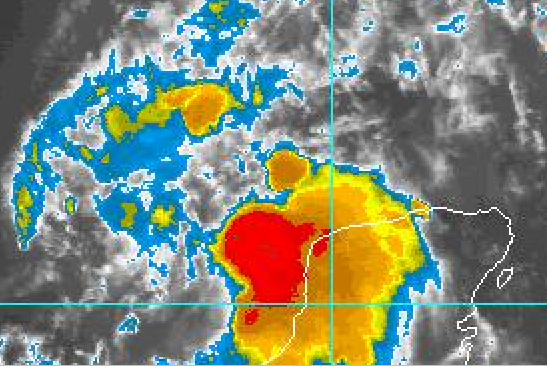
When you see deep convection develop all of the sudden during the evening near land (as with what we see now)...that's generally a good indication it's diurnal in nature. It probably won't last overnight.
It should begin to drift to the NNE or NE over the next 24 hours as it gets pulled by the shortwave trough. And what lies to the NE besides the trough? SHEAR. With that being said, don't expect it to develop...it will get pulled BY the shortwave right INTO the shortwave. Not the prettiest scenario if you're looking for development.
HEY!!! Where is that thing going?
It should begin to drift to the NNE or NE over the next 24 hours as it gets pulled by the shortwave trough. And what lies to the NE besides the trough? SHEAR. With that being said, don't expect it to develop...it will get pulled BY the shortwave right INTO the shortwave. Not the prettiest scenario if you're looking for development.
0 likes
-
Rainband
May explain why we are undera flood watch lolSupercane wrote:When you see deep convection develop all of the sudden during the evening near land (as with what we see now)...that's generally a good indication it's diurnal in nature. It probably won't last overnight.HEY!!! Where is that thing going?
It should begin to drift to the NNE or NE over the next 24 hours as it gets pulled by the shortwave trough. And what lies to the NE besides the trough? SHEAR. With that being said, don't expect it to develop...it will get pulled BY the shortwave right INTO the shortwave. Not the prettiest scenario if you're looking for development.
0 likes
-
Rainband
-
Anonymous
-
Rainband
-
Rainband
No end in sight to this plume of moisture coming from The GOM..I was looking a satellite images and a broad low looks to be organizing off SW florida.remnants of a wave that passed the straits I think....or maybe it's water in my eyes lol 
 Yep..just checked it was water...
Last edited by Rainband on Thu Jun 19, 2003 1:10 pm, edited 1 time in total.
0 likes
-
wx247

- S2K Supporter

- Posts: 14279
- Age: 42
- Joined: Wed Feb 05, 2003 10:35 pm
- Location: Monett, Missouri
- Contact:
Supercane wrote:Joshua21Young wrote:Shear sucks. It never lets anything develop.
Don't worry man. It's only June. Be happy that we're even getting this many disturbances at this time of year lol.
That is true... it is only the 19th of June and we have already had Ana and TD#2. That is pretty active I would say. We just have to stay patient. If you get bored, check out the EPAC.
0 likes
Personal Forecast Disclaimer:
The posts in this forum are NOT official forecast and should not be used as such. They are just the opinion of the poster and may or may not be backed by sound meteorological data. They are NOT endorsed by any professional institution or storm2k.org. For official information, please refer to the NHC and NWS products.
The posts in this forum are NOT official forecast and should not be used as such. They are just the opinion of the poster and may or may not be backed by sound meteorological data. They are NOT endorsed by any professional institution or storm2k.org. For official information, please refer to the NHC and NWS products.

-
Rainband
-
GulfBreezer

- Category 5

- Posts: 2230
- Joined: Wed Oct 09, 2002 8:58 pm
- Location: Gulf Breeze Fl
- Contact:
-
ColdFront77
The central Florida forecast as of the last few hours is for on and off light, moderate to heavy rain with some thunderstorms lasting for the next 48 hours and than to more typical summertime thunderstorm activity Sunday to the middle of next week.
If this flow off the Gulf of Mexico continues, showing no signs of shifting than even on and off rain above typical summertime standards could last into the weekend.
If this flow off the Gulf of Mexico continues, showing no signs of shifting than even on and off rain above typical summertime standards could last into the weekend.
0 likes
Who is online
Users browsing this forum: cycloneye and 119 guests