The January 5-12, 2007 Warm Spell: Some Thoughts

Winter Weather Discussion

Moderator: S2k Moderators

Forum rules

The posts in this forum are NOT official forecast and should not be used as such. They are just the opinion of the poster and may or may not be backed by sound meteorological data. They are NOT endorsed by any professional institution or STORM2K.

Help Support Storm2K
Message
Author
donsutherland1
S2K Analyst
S2K Analyst
Posts: 2718
Joined: Mon Sep 15, 2003 8:49 pm
Location: New York

The January 5-12, 2007 Warm Spell: Some Thoughts

#1 Postby donsutherland1 » Tue Dec 26, 2006 9:23 am

Since December 23, the GFS ensembles have grown increasingly impressed with the idea of a January "blowtorch." As a result, a closer look is in order.

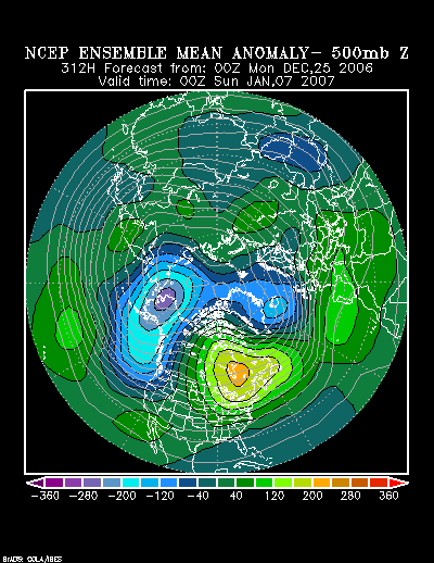
The NCEP ensemble 500 mb anomalies forecast for 312 hours (1/7 0z) are:
Image

That fits well with a number of historic warm periods that occurred in the January 1-15 timeframe since 1950:

North American Composite 500 mb height anomalies:
Image

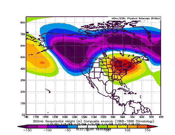
Northern Hemisphere Composte 500 mb height anomalies:
Image

The NCEP ensemble 850 mb temperature anomalies forecast for 312 hours (1/7 0z) are:
Image

During those periods for which the above height anomalies were present, the highest temperature reached in select cities was:

January 3-6, 1951:
Atlanta: 66°
Boston: 60°
Burlington: 50°
Chicago: 41°
Detroit: 51°
New York City: 61°
Philadelphia: 64°
Richmond: 70°
Washington, DC: 65°

January 1-5, 1966:
Atlanta: 68°
Boston: 61°
Burlington: 56°
Chicago: 49°
Detroit: 47°
New York City: 62°
Philadelphia: 60°
Richmond: 70°
Washington, DC: 68°

January 2-9, 1998:
Atlanta: 68°
Boston: 60°
Burlington: 47°
Chicago: 58°
Detroit: 56°
New York City: 65°
Philadelphia: 69°
Richmond: 71°
Washington, DC: 69°

January 1-4, 2000:
Atlanta: 73°
Boston: 64°
Burlington: 55°
Chicago: 60°
Detroit: 57°
New York City: 64°
Philadelphia: 67°
Richmond: 74°
Washington, DC: 71°

January 9-11, 2000:
Atlanta: 67°
Boston: 56°
Burlington: 44°
Chicago: 46°
Detroit: 49°
New York City: 58°
Philadelphia: 59°
Richmond: 64°
Washington, DC: 59°

At this time, that kind of warmth should be seen as offering some insight into the potential magnitude of the 1/5-12 warm period at its warmest: 50° or better in Chicago and Detroit, 60s or above in the Mid-Atlantic region (possibly a 70° reading in parts of the Mid-Atlantic e.g., at Richmond), possibly 60° or above as far north as Boston and 50° or above in Burlington.
0 likes   

User avatar
Portastorm
Storm2k Moderator
Storm2k Moderator
Posts: 9914
Age: 63
Joined: Fri Jul 11, 2003 9:16 am
Location: Round Rock, TX
Contact:

#2 Postby Portastorm » Tue Dec 26, 2006 10:16 am

Don, as usual, your presentation and argument is cogent and sensible! I do have a question though ... it appears that the NCEP ensembles and the GFS operational runs are not in agreement at certain periods .. for example, the 0z and 6z GFS operational runs for 12/26 show two distinct cold blasts impacting the Southern Plains over the next 360 hrs. However, the ensembles do not show any deviations below normal during that period. Is such discordance unusual?
0 likes   

donsutherland1
S2K Analyst
S2K Analyst
Posts: 2718
Joined: Mon Sep 15, 2003 8:49 pm
Location: New York

#3 Postby donsutherland1 » Tue Dec 26, 2006 2:01 pm

Portastorm,

More often than not, a consistent signal on the NCEP ensembles outperforms the operational GFS in the longer-range. So far, the ensembles have been rock solid with the idea of a coming explosion of warmth that will see a generally mild pattern become even warmer. However, there are growing hints that the long positive Arctic Oscillation regime may crumble after January 10. If that happens, such regime changes have often been followed by a 30-day period of increased blocking.

The Southern Plains, though are not likely to see temperatures rocket as will happen from the Northern Plains and then eastward. A continuing active subtropical jet should keep things cooler albeit milder than normal for the most part.
0 likes   

User avatar
Janie2006
Category 5
Category 5
Posts: 1329
Joined: Mon Sep 18, 2006 3:28 pm
Location: coastal Ms aka home of the hurricanes

#4 Postby Janie2006 » Tue Dec 26, 2006 2:10 pm

It appears that the core of the abnormal warmth may very well be over the Ohio Valley, the NE, and the mid-Atlantic. Temperatures along the Gulf Coast may be running a bit above normal, but I don't know that it would be record-breaking warmth. As you say, Don, it may be the southern branch that keeps things in check here.

Thus far, it seems that the El Nino pattern is holding. Overall the wx here hasn't been all that abnormally cold or too terribly warm, aside from the few days we had in the 70s here along the coast. Certainly the southern branch has kept us supplied with moisture.
0 likes   

aggiecutter
Category 5
Category 5
Posts: 1753
Joined: Thu Oct 14, 2004 9:22 pm
Location: Texarkana

#5 Postby aggiecutter » Tue Dec 26, 2006 3:52 pm

The CPC agrees. It looks like the blowtorch is on the way for the first couple weeks of the new year. Hopefully, the polar jet will get involved with one of these El Nino systems sometime from mid January through mid February. Chances are pretty good that one of those systems will and produce a significant winter storm for Texas. Until then, get out the shorts and T-shirts.

CPC 8-14:
http://www.cpc.noaa.gov/products/predic ... mp.new.gif
Last edited by aggiecutter on Tue Dec 26, 2006 7:03 pm, edited 1 time in total.
0 likes   

gunner1551
Tropical Storm
Tropical Storm
Posts: 143
Joined: Thu Sep 16, 2004 12:08 pm

#6 Postby gunner1551 » Tue Dec 26, 2006 5:35 pm

I wouldnt profess to be an expert at reading these ensembles, so correct me if I am wrong, this spells above normal warmth for the east ( yellows, orange, reds ) on the 500 mb height, and below normal warmth for the west ( blues and purples ), would I be correct in assuming this?

oops i seem to have read the graphs for the 60's instead of the present. My question still stands will the west be cool, and the east warmer?
0 likes   

User avatar
wxmann_91
Category 5
Category 5
Posts: 8013
Age: 34
Joined: Fri Jul 15, 2005 2:49 pm
Location: Southern California
Contact:

#7 Postby wxmann_91 » Tue Dec 26, 2006 8:43 pm

If those maps verify, Alaska's the only place that will be below average in the U.S.
0 likes   

User avatar
TampaFl
S2K Supporter
S2K Supporter
Posts: 1904
Age: 67
Joined: Thu Sep 04, 2003 11:23 am
Location: Tampa, FL

#8 Postby TampaFl » Wed Dec 27, 2006 8:52 am

Don, from the NWS Tampa AFD this morning. It is in the mid 40s this morning & forcasted for Thursday morning, but a rapid warm up to the low 80s again for the weekend. Finally getting some decent rains with unfortunatly tornados (El Ninoish like), but it sure does not fell or look like a typical El Nino winter here, more like an La Nino temperature wise.

000
FXUS62 KTBW 270800
AFDTBW

WEST CENTRAL AND SOUTHWEST FLORIDA FORECAST DISCUSSION
NATIONAL WEATHER SERVICE TAMPA BAY RUSKIN FL
300 AM EST WED DEC 27 2006

.LONG TERM (FRIDAY NIGHT - TUESDAY)...AFTER SEVERAL DAYS OF MODEL
DIFFERENCES IN THE EVENTUAL OUTCOME OF THE NEXT SOUTHWEST
U.S/SOUTHERN ROCKIES STORM SYSTEM...THE LATEST RUNS OF THE GLOBAL
MODELS ARE FINALLY IN A REASONABLE AGREEMENT WITH ONLY ONE REMAINING
OUTLIER (THE NOGAPS). THROUGH IT ALL...THE CANADIAN GEM HAS BEEN
MOST CONSISTENT IN THE TIMING OF THE WEEKEND EVENT AND BOTH THE
ECMWF (FASTER) AND GFS (SLOWER) HAVE NOT ONLY MET THE CANADIAN GEM
SOLUTION BUT ARE VERY CLOSE IN THE POSITION OF THE BROAD VORTEX BY
LATE IN THE WEEKEND.

IN SHORT...AFTER A SLOW STROLL THROUGH NEW MEXICO AND TEXAS (DON`T
TELL DENVER!)...THE SYSTEM SHOULD ONCE AGAIN DEFLECT NORTHEAST INTO
THE MID MISSISSIPPI VALLEY BY NEW YEAR`S EVE AS THE
CARIBBEAN/BAHAMAS RIDGE WHICH HAS THUS FAR PUMPED MEAN TEMPERATURES
(AS OF CHRISTMAS DAY) 6.6 DEGREES ABOVE NORMAL AT TAMPA (2ND ALL
TIME AVERAGE) REMAINS THE IMMOVABLE OBJECT.
THUS...THE POSSIBLE
BROKEN LINE OF SHOWERS/THUNDERSTORMS IS MOST LIKELY LATE SATURDAY
NIGHT INTO SUNDAY MORNING WHICH IS FAIRLY CLOSE TO WHAT WE`VE BEEN
FORECASTING FOR THE PAST FEW DAYS. WHICH MEANS THE FIRST HALF OF
THE HOLIDAY WEEKEND...AT LEAST...WILL BE RAIN-FREE AND WARM.

BY NEW YEAR`S EVE AND BEYOND...THE OUTLOOK MIGHT NOT BE SO ROSY. THE
CANADIAN...ECMWF...AND GFS ALL HINT AT A CONTINUING SOUTHWEST FLOW
AND WAVES OF ENERGY RIDING THROUGH IT...LEAVING PLENTY OF DEEP LAYER
SUBTROPICAL MOISTURE TO MOVE ACROSS A DISSIPATING FRONTAL BOUNDARY
SOMEWHERE ACROSS THE PENINSULA. THUS...WILL BE A BIT MORE
PESSIMISTIC REGARDING SUNSHINE BY DAYS 6/7.

FOR THE SENSIBLE WEATHER...SATURDAY SHOULD BE LARGELY DRY THOUGH
CAN`T RULE OUT A PASSING LIGHT SHOWER AS LOW LEVEL MOISTURE
INCREASES ON SOUTHEAST FLOW. NO CHANGES TO TEMPERATURE
FORECAST...BALMY 80+ IN MOST AREAS LOOKS ON TRACK. FOR SATURDAY
NIGHT AND SUNDAY...HAVE EDGED THUNDERSTORM CHANCES BACK INTO SUNDAY
MORNING AS A PEAK...AND THIS MAY HAVE TO BE ADJUSTED A BIT FARTHER
INTO THE DAY. LINGERING SHOWERS AND PLENTY OF CLOUDS WILL CONTINUE
NEW YEARS EVE INTO NEW YEARS DAY...WITH THE EXCEPTION BEING THE
NATURE COAST WHERE SOME CLEARING OF THE LOW LEVEL MOISTURE IS
POSSIBLE. GIVEN THE INCREASED MOISTURE...WE`VE PUSHED UP
TEMPERATURES A FEW DEGREES PARTICULARLY AT NIGHT.

JANUARY 2ND (DAY 7) WILL BE HIGHLY DEPENDENT ON HOW MUCH OF A NUDGE
THE MOISTURE GETS FROM THE WESTERLY FLOW AT THE BASE OF THE CLOSED
LOW WHICH MOVES THROUGH THE GREAT LAKES. GFS HAS BACKED OFF ON
WIDESPREAD CLEARING...AND IS MORE IN LINE WITH OTHER GLOBAL MODELS.
FOR NOW...HAVE INTRODUCED SLIGHT CHANCES OF SHOWERS AND BUMPED SKY
COVER A BIT...AS WELL AS TEMPERATURES AND DEW POINTS.

IN SHORT...THERE`S NO SENSE IN FIGHTING THE SUBTROPICAL RIDGE TO OUR
EAST AND SOUTH UNTIL WE SEE A VIGOROUS SYSTEM TRULY ALTER THE
PATTERN. THE NEXT SEVEN DAYS...AS THE PAST MONTH BEFORE...WILL
AVERAGE ABOVE NORMAL.

&&

. SHORT TERM/MARINE...RKR
LONG TERM/AVIATION...BSG
0 likes   

donsutherland1
S2K Analyst
S2K Analyst
Posts: 2718
Joined: Mon Sep 15, 2003 8:49 pm
Location: New York

#9 Postby donsutherland1 » Thu Dec 28, 2006 4:10 pm

As a first "test" of the blowtorch idea, there is a huge gap among the forecasts made by the MOS (MEX), 12/28 12z ECMWF, and 12/28 0z GFS ensembles for January 4 for Bismarck (KBIS) and Rapid City (KRAP).

The ensemble idea has been highly consistent. If anything, it has trended even warmer in recent days. The following is the latest NCEP ensemble 850 mb temperature anomalies forecast for 1/4 0z:

Image

January 5, 2007 0z:
Image

The 12/28 12z ECMWF is forecasting the following 850 mb temperatures:

Bismarck: +9.6°C
Rapid City: +9.7°C

Meanwhile the 12/28 12z MOS (MEX) is showing the following high temperatures for January 4, 2007:

Bismarck: 29°
Rapid City: 39°

In my view, both cities will probably see high temperatures closer to 50° than the figures shown on the MOS (MEX). Highs into the 50s for both places are possible on January 4, though 40s may be more likely especially in Bismarck.

What happens there could well provide an indication as to whether the "blowtorch" idea farther east at some point during the January 5-12 warm spell is likely to verify.
0 likes   

User avatar
gatorcane
S2K Supporter
S2K Supporter
Posts: 23691
Age: 47
Joined: Sun Mar 13, 2005 3:54 pm
Location: Boca Raton, FL

#10 Postby gatorcane » Sun Dec 31, 2006 11:57 am

Thanks Don for your analysis. I really can't believe how warm this winter has been so far. I don't remember a winter this warm in a long time across the Eastern CONUS. As some people have been saying, usually "we pay the price" later in the winter season for having a warmer early winter but I'm wondering if that is even going to happen this year. Looks like the cold air will be ushered in around the Jan 15th timeframe? I would expect the second half of winter to be generally cold for the Eastern CONUS considering how warm the first half has been.
0 likes   

JBG
Tropical Storm
Tropical Storm
Posts: 146
Joined: Fri Apr 29, 2005 12:34 pm
Location: New York City area
Contact:

#11 Postby JBG » Sun Dec 31, 2006 12:04 pm

gatorcane wrote:Thanks Don for your analysis. I really can't believe how warm this winter has been so far. I don't remember a winter this warm in a long time across the Eastern CONUS. As some people have been saying, usually "we pay the price" later in the winter season for having a warmer early winter but I'm wondering if that is even going to happen this year. Looks like the cold air will be ushered in around the Jan 15th timeframe? I would expect the second half of winter to be generally cold for the Eastern CONUS considering how warm the first half has been.


2001-2 and 1999-2000 had similarly warm starts. Ditto December 1982, December 1984 (though January 1985 cooled down).
0 likes   

donsutherland1
S2K Analyst
S2K Analyst
Posts: 2718
Joined: Mon Sep 15, 2003 8:49 pm
Location: New York

#12 Postby donsutherland1 » Mon Jan 01, 2007 5:47 pm

From Thursday (12/28/2006):

...the 12/28 12z MOS (MEX) is showing the following high temperatures for January 4, 2007:

Bismarck: 29°
Rapid City: 39°

In my view, both cities will probably see high temperatures closer to 50° than the figures shown on the MOS (MEX). Highs into the 50s for both places are possible on January 4, though 40s may be more likely especially in Bismarck.


The 1/1 12z MOS (MEX) figures for 1/4's maximum temperatures are:

Bismarck: 41°
Rapid City: 51°

It is possible that 1/3 might be the warmest day in one or both of these cities.

All said, coming exceptional warmth appears likely into the East afterward. I believe the warmth will peak in the January 5-8 timeframe. In Chicago and the Great Lakes region, temperatures could peak a day or two earlier.

On 12/25/2006 I noted:

At this time, that kind of warmth should be seen as offering some insight into the potential magnitude of the 1/5-12 warm period at its warmest: 50° or better in Chicago and Detroit, 60s or above in the Mid-Atlantic region (possibly a 70° reading in parts of the Mid-Atlantic e.g., at Richmond), possibly 60° or above as far north as Boston and 50° or above in Burlington.

1/1/2007 12z MOS (MEX) forecasts for the highest temperature in the 1/5-8 timeframe (January 3-7 for Chicago and Detroit) are as follows:

Boston: 54°
Burlington: 47°
Chicago: 49°
Detroit: 48°
New York City: 59°
Philadelphia: 64°
Richmond: 70°
Washington, DC (DCA): 64°
0 likes   

User avatar
Lowpressure
S2K Supporter
S2K Supporter
Posts: 2032
Age: 58
Joined: Sun Sep 14, 2003 9:17 am
Location: Charlotte, North Carolina

#13 Postby Lowpressure » Mon Jan 01, 2007 6:49 pm

NWS Charlotte finally mentioning long wave trough pattern change possible after day 7.
0 likes   

JBG
Tropical Storm
Tropical Storm
Posts: 146
Joined: Fri Apr 29, 2005 12:34 pm
Location: New York City area
Contact:

#14 Postby JBG » Mon Jan 01, 2007 6:57 pm

Lowpressure wrote:NWS Charlotte finally mentioning long wave trough pattern change possible after day 7.


Does this tie into AO at all?
0 likes   

User avatar
Lowpressure
S2K Supporter
S2K Supporter
Posts: 2032
Age: 58
Joined: Sun Sep 14, 2003 9:17 am
Location: Charlotte, North Carolina

#15 Postby Lowpressure » Mon Jan 01, 2007 9:38 pm

JBG wrote:
Lowpressure wrote:NWS Charlotte finally mentioning long wave trough pattern change possible after day 7.


Does this tie into AO at all?


Yes, it does. It shows the first signs of the decay Don has discussed being mentioned in extended forecasts. It helps to start to narrow down a date towards colder weather which would indicate a possible tanking or negative AO.
0 likes   

Jim Cantore

#16 Postby Jim Cantore » Mon Jan 01, 2007 10:01 pm

Warm spell?? No go away! I already have the AC on. :cheesy:
0 likes   

donsutherland1
S2K Analyst
S2K Analyst
Posts: 2718
Joined: Mon Sep 15, 2003 8:49 pm
Location: New York

#17 Postby donsutherland1 » Tue Jan 02, 2007 1:25 pm

From Thursday (12/28/2006):

...the 12/28 12z MOS (MEX) is showing the following high temperatures for January 4, 2007:

Bismarck: 29°
Rapid City: 39°

In my view, both cities will probably see high temperatures closer to 50° than the figures shown on the MOS (MEX). Highs into the 50s for both places are possible on January 4, though 40s may be more likely especially in Bismarck.


The 1/2 12z MOS (MEX) figures for 1/4's maximum temperatures are:

Bismarck: 41°
Rapid City: 51°

It is possible that 1/3 might be the warmest day in one or both of these cities.

At the beginning of this thread, I noted:

At this time, that kind of warmth should be seen as offering some insight into the potential magnitude of the 1/5-12 warm period at its warmest: 50° or better in Chicago and Detroit, 60s or above in the Mid-Atlantic region (possibly a 70° reading in parts of the Mid-Atlantic e.g., at Richmond), possibly 60° or above as far north as Boston and 50° or above in Burlington.

1/2/2007 12z MOS (MEX) forecasts for the highest temperature in the 1/5-8 timeframe:

Boston: 55°
Burlington: 47°
Chicago: 51°
Detroit: 50°
New York City: 62°
Philadelphia: 63°
Richmond: 72°
Washington, DC (DCA): 69°
0 likes   

donsutherland1
S2K Analyst
S2K Analyst
Posts: 2718
Joined: Mon Sep 15, 2003 8:49 pm
Location: New York

#18 Postby donsutherland1 » Wed Jan 03, 2007 9:32 am

Blowtorch update:

At 8 am CST, the temperature at Bismarck stood at 40°. The morning low was 27°. The normal figures for this date are a high of 21° and a low of -1°.

Record Highs for January 3 and 4 are:

January 3: 49°, 1962
January 4: 44°, 2001

From Thursday (12/28/2006):

...the 12/28 12z MOS (MEX) is showing the following high temperatures for January 4, 2007:

Bismarck: 29°
Rapid City: 39°

In my view, both cities will probably see high temperatures closer to 50° than the figures shown on the MOS (MEX). Highs into the 50s for both places are possible on January 4, though 40s may be more likely especially in Bismarck.


The 1/3 0z MOS (MEX) figures for 1/4's maximum temperatures are:

Bismarck: 45°
Rapid City: 50°

This blowtorch should come east in coming days.
0 likes   

donsutherland1
S2K Analyst
S2K Analyst
Posts: 2718
Joined: Mon Sep 15, 2003 8:49 pm
Location: New York

#19 Postby donsutherland1 » Wed Jan 03, 2007 12:06 pm

At the beginning of this thread, I noted:

At this time, that kind of warmth should be seen as offering some insight into the potential magnitude of the 1/5-12 warm period at its warmest: 50° or better in Chicago and Detroit, 60s or above in the Mid-Atlantic region (possibly a 70° reading in parts of the Mid-Atlantic e.g., at Richmond), possibly 60° or above as far north as Boston and 50° or above in Burlington.

1/3/2007 12z MOS (MEX) forecasts for the highest temperature in the 1/5-8 timeframe:

Boston: 58°
Burlington: 49°
Chicago: 52°
Detroit: 54°
New York City: 63°
Philadelphia: 66°
Richmond: 73°
Washington, DC (DCA): 69°
0 likes   

donsutherland1
S2K Analyst
S2K Analyst
Posts: 2718
Joined: Mon Sep 15, 2003 8:49 pm
Location: New York

#20 Postby donsutherland1 » Thu Jan 04, 2007 12:20 am

The 1/4 0z ETA MOS and GFS (MAV) MOS are exceptionally warm, particularly the summerlike ETA MOS.

ETA MOS:
Boston: 64°
Burlington: 52°
Chicago: 52°
Detroit: 52°
New York City: 70°
Philadelphia: 68°
Richmond: 72°
Washington, DC (DCA): 72°

GFS (MAV) MOS:
Boston: 60°
Burlington: 49°
Chicago: 52°
Detroit: 54°
New York City: 65°
Philadelphia: 65°
Richmond: 71°
Washington, DC (DCA): 69°
0 likes   


Return to “Winter Weather”

Who is online

Users browsing this forum: No registered users and 8 guests