Texas Winter Weather Thread #3 - GFS showing cold christmas

Winter Weather Discussion

Moderator: S2k Moderators

Forum rules

The posts in this forum are NOT official forecast and should not be used as such. They are just the opinion of the poster and may or may not be backed by sound meteorological data. They are NOT endorsed by any professional institution or STORM2K.

Help Support Storm2K
Message
Author
User avatar
southerngale
Retired Staff
Retired Staff
Posts: 27418
Joined: Thu Oct 10, 2002 1:27 am
Location: Southeast Texas (Beaumont area)

#281 Postby southerngale » Fri Dec 15, 2006 2:26 pm

Although I will continue to hope for snow until I get to build a snowman, I will be glad if it's just cold for Christmas. I can't stand it when it's warm on Christmas...just doesn't feel right. I like for it to actually LOOK like Christmas/winter in pics, and not like we're celebrating it in July! And I love to have a fire on Christmas Eve. It's not quite the same if you have to run the A/C on high to do so. :P


Btw, have you sent in your MOTM nomination?
http://www.storm2k.org/phpbb2/viewtopic.php?t=91795
0 likes   

aggiecutter
Category 5
Category 5
Posts: 1753
Joined: Thu Oct 14, 2004 9:22 pm
Location: Texarkana

#282 Postby aggiecutter » Fri Dec 15, 2006 4:30 pm

The NCEP Experimental Medium range model sticks a major league trough in the central part of the country in 2 weeks. If this were to happen, this could be a precursor to a cold, wintry January.

NCEP Model 500mb:
http://www.cdc.noaa.gov/people/jeffrey. ... 0_pna.html

NCEP Model 850mb deviations: -6 to -8 over Texas. Very impressive.
http://www.cdc.noaa.gov/people/jeffrey. ... 21500.html
0 likes   

User avatar
Extremeweatherguy
Category 5
Category 5
Posts: 11095
Joined: Mon Oct 10, 2005 8:13 pm
Location: Florida

#283 Postby Extremeweatherguy » Fri Dec 15, 2006 11:35 pm

The 0Z GFS has really flip-flopped for next week. It now has the low MUCH further north with a weaker, slower cold front, less of a severe weather threat and possibly much less cold air (it is showing highs in the mid to upper 60s Wed. and Thurs. compared to the 50s it showed in earlier runs). I don't buy this solution one bit though (until we see consistancy), and I think the GFS is on crazy pills as this is almost a complete flip from earlier runs. Hopefully tomorrow's runs will become a little bit more consistant.

One difference I am noticing between the GFS and the NAM tonight is the positioning of the system as it starts out. The NAM has it near the S. California-Mexico-Arizona border in 84 hrs. while the GFS has it much further north near the California-Nevada-Arizona border at that same time. The NAM's more southerly idea could mean a more southerly track and thus a different scenario (cooler) for us Texans.

I am sure the next 1-2 days will bear more interesting model runs. :roll: Can't wait until next Mon/Tues when we will finally get a grasp on what will really happen.

**The 0Z GFS does however bring in an area of colder weather by next Friday morning though...so the main temperature difference from earlier runs seems to be in the Wed.-Thurs. timeframe. It also shows increasing precip. by next Friday as well.**

Here is a link to the 0Z run: http://www.nco.ncep.noaa.gov/pmb/nwprod ... /fpc.shtml
0 likes   

User avatar
jasons2k
Storm2k Executive
Storm2k Executive
Posts: 8245
Age: 51
Joined: Wed Jul 06, 2005 12:32 pm
Location: The Woodlands, TX

#284 Postby jasons2k » Sat Dec 16, 2006 12:11 am

EWG will not be too happy when he reads Don Sutherland's latest analysis:

http://www.storm2k.org/phpbb2/viewtopic ... 45#1499345
0 likes   

User avatar
Portastorm
Storm2k Moderator
Storm2k Moderator
Posts: 9914
Age: 63
Joined: Fri Jul 11, 2003 9:16 am
Location: Round Rock, TX
Contact:

#285 Postby Portastorm » Sat Dec 16, 2006 8:55 am

For anyone who has been perusing the GFS the last 2 days, you know how variable each run has been ... especially with regard to the developing storm system out west. The GFS, Euro, and Canadian are in major disagreement as to how this week is going to play out.

The good forecasters in Amarillo (shout out to wall_cloud! :D ) had an interesting tidbit as to why in their morning discussion:

"WITH THE MODELS STILL WORKING TOWARDS THE ACCURATE SOLUTION...CONFIDENCE IS NOT MUCH HIGHER THAN YESTERDAY...ESPECIALLY AS THE STORM MOVES OVER DATA SPARSE AREAS ALONG AND SOUTH OF THE U.S BORDER."

So folks, the jury is still out for us Southern Plainsfolk for this week as we look at less rain/more mild vs. more rain/more seasonal. I'm hoping for th latter.

The morning ensembles, btw, still show a colder than normal airmass taking charge in the southern Plains by next weekend.

And ... {putting my JB sycophant hat on} ... JB is still bullish on a snow/ice event in the farther northern and northwest reaches of Texas and then a decent cooldown.
0 likes   

User avatar
gboudx
S2K Supporter
S2K Supporter
Posts: 4080
Joined: Thu Sep 04, 2003 1:39 pm
Location: Rockwall, Tx but from Harvey, La

#286 Postby gboudx » Sat Dec 16, 2006 9:03 am

jschlitz wrote:EWG will not be too happy when he reads Don Sutherland's latest analysis:

http://www.storm2k.org/phpbb2/viewtopic ... 45#1499345


A warm January huh? Maybe I shouldn't winterize my lawnmower afterall. Grass may start popping up early like last year.

Hopefully, we get rain to alleviate the drought conditions.
0 likes   

aggiecutter
Category 5
Category 5
Posts: 1753
Joined: Thu Oct 14, 2004 9:22 pm
Location: Texarkana

#287 Postby aggiecutter » Sat Dec 16, 2006 9:31 am

Warm, not hardly. Texarkana will have a blizzard on the 29th of this month. If you don't believe me, just look at the 6z GFS, which is never wrong.

6zGFS:
http://www.nco.ncep.noaa.gov/pmb/nwprod ... _312.shtml
0 likes   

User avatar
cheezyWXguy
Category 5
Category 5
Posts: 6108
Joined: Mon Feb 13, 2006 12:29 am
Location: Dallas, TX

#288 Postby cheezyWXguy » Sat Dec 16, 2006 9:39 am

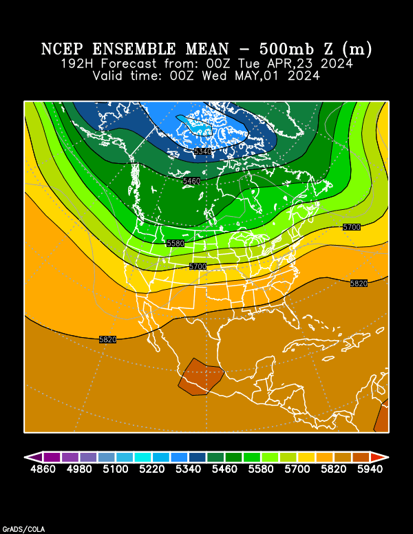
aggiecutter wrote:Warm, not hardly. Texarkana will have a blizzard on the 29th of this month. If you don't believe me, just look at the 6z GFS, which is never wrong.

6zGFS:
http://www.nco.ncep.noaa.gov/pmb/nwprod ... _312.shtml


Wow...if that werent 13 days out id totally buy it! Nonetheless, I really do hope it happens because itd be snowing pretty near my birthday (Jan1)
0 likes   

double D
Category 1
Category 1
Posts: 485
Joined: Wed Feb 15, 2006 8:17 pm
Location: Austin, Tx

#289 Postby double D » Sat Dec 16, 2006 10:18 am

Maybe we should change the title of the thread back to "more mild weather ahead" It doesn't look like much of a cool down next week according to Austin/San Antonio NWS: It is so funny how they seem to change their forecast numbers on every single run of the GFS. :roll:
0 likes   

User avatar
Portastorm
Storm2k Moderator
Storm2k Moderator
Posts: 9914
Age: 63
Joined: Fri Jul 11, 2003 9:16 am
Location: Round Rock, TX
Contact:

#290 Postby Portastorm » Sat Dec 16, 2006 11:34 am

double D wrote:Maybe we should change the title of the thread back to "more mild weather ahead" It doesn't look like much of a cool down next week according to Austin/San Antonio NWS: It is so funny how they seem to change their forecast numbers on every single run of the GFS. :roll:


Sheesh ... don't get me started! :grr:

Their morning discussion totally went down the GFS road ... they took the "oh no, the GFS has totally changed it scenario for next week so we better change our forecast" ... meanwhile, a calmer, more sensible approach from the Fort Worth NWS office roughly said "GFS out to lunch, Euro and Canadian more consistent so we will go with the latter."

Live by the GFS, die by the GFS.

I guess it all depends on which forecaster is on duty. Like anything else, some are better than others.
0 likes   

User avatar
weatherrabbit_tx
Category 1
Category 1
Posts: 270
Joined: Wed Dec 21, 2005 3:13 pm
Location: Kingwood,Tx
Contact:

#291 Postby weatherrabbit_tx » Sat Dec 16, 2006 11:37 am

all this flip flopping makes the doughboy sick with motion sickness :coaster:
however every once in a while the gfs like a blind hog with get the acorn
Last edited by weatherrabbit_tx on Sat Dec 16, 2006 11:43 am, edited 1 time in total.
0 likes   

User avatar
cheezyWXguy
Category 5
Category 5
Posts: 6108
Joined: Mon Feb 13, 2006 12:29 am
Location: Dallas, TX

#292 Postby cheezyWXguy » Sat Dec 16, 2006 11:42 am

One thing ive noticed though...whether this means anything or not...the past 4 runs of the GFS(not including the brand new 12z, which is still coming out) have shown a large arctic airmass coming down on the 16th day, with the 6z today being the most vigorous. I know not to trust...i barely think anyting of the scenario itself...but i do think its interesting that for the past 4 consecutive runs its shown something, even if it is on 384 hour

6z this morning:
http://www.nco.ncep.noaa.gov/pmb/nwprod ... _384.shtml
0z
http://www.nco.ncep.noaa.gov/pmb/nwprod ... _384.shtml
18z from last night
http://www.nco.ncep.noaa.gov/pmb/nwprod ... _384.shtml
Last edited by cheezyWXguy on Sat Dec 16, 2006 11:45 am, edited 1 time in total.
0 likes   

User avatar
Extremeweatherguy
Category 5
Category 5
Posts: 11095
Joined: Mon Oct 10, 2005 8:13 pm
Location: Florida

#293 Postby Extremeweatherguy » Sat Dec 16, 2006 11:45 am

The 12Z GFS coming in and so far it is much faster with the front and a tad further south with the low pressure compared to earlier runs. It now looks like the front should reach Houston by late Wednesday night or early Thursday morning with a squall line out ahead of it.

Here is the comparison between the 12z and 0z runs:

12z GFS at hour 102 = http://www.nco.ncep.noaa.gov/pmb/nwprod ... _102.shtml
^^low pressure over OK panhandle^^

0z GFS at hour 114 (equivalent to 102 on 12Z) = http://www.nco.ncep.noaa.gov/pmb/nwprod ... _114.shtml
^^low pressure in NE/SD^^

Difference: The 0Z shows a weaker, slower system with less moisture out ahead of it over TX. The 0Z was also much further north meaning less cold air and less chance of rain/storms. However, the 12Z is 100s of miles further south, meaning more of an influence to our weather.

12z GFS at hour 114 = http://www.nco.ncep.noaa.gov/pmb/nwprod ... _114.shtml
^^low pressure over KS^^

0z GFS at hour 126 (equivalent to 114 on 12Z) = http://www.nco.ncep.noaa.gov/pmb/nwprod ... _126.shtml
^^low pressure over SD^^

Difference: The 12Z shows a much stronger system, much further south (100s of miles further south). It also shows the front arriving much sooner for the Houston area. This would mean a shorter wait for heat relief and possibly more rain/storms ahead of the front.


SO BASICALLY: In a nutshell, the 12Z run is showing a stronger low, and is moving it slightly further south than the 0Z run. This would mean a much quicker front for the Houston area (around midnight Thursday morning instead of Thursday afternoon/evening), and could possibly mean a better chance of rain and storms ahead of it. It may also lead to slightly cooler temperatures as well. What we need to see now though is if this trend continues. If the low continues to be forecast much stronger and if the southward placement continues in future runs, then we may indeed be looking at an interesting situation. The best case for those wanting a real strong shot of chilly air would be if the low placement gets moved even further south. If, for instance, the low moves across north TX (as shown in earlier runs a few days back) instead of across KS, then we could very well be looking at a chilly weather scenario for the state with possible winter weather in northern areas.

Lots to watch as the flip-flops continue...

As of now though, the latest run does seem to indicate possibly a quicker, stronger frontal passage than the 0Z did. We will just have to see if the trend continues.
0 likes   

User avatar
Extremeweatherguy
Category 5
Category 5
Posts: 11095
Joined: Mon Oct 10, 2005 8:13 pm
Location: Florida

#294 Postby Extremeweatherguy » Sat Dec 16, 2006 11:55 am

BTW, the 12Z is showing some chilly air back in the forecast around Christmas with chilly days and cold nights, check it out:

http://www.nco.ncep.noaa.gov/pmb/nwprod ... _192.shtml
^^Christmas Eve morning - 540 thickness line extends well southward into the state with northern 2/3rds of state having 850mb temps. below 0C. Flurries even look possible in N. Texas^^

It then shows highs in the 50s on Christmas Eve day.

http://www.nco.ncep.noaa.gov/pmb/nwprod ... _216.shtml
^^Christmas morning looks to be a chilly one in the 30s with temperatures then warming into the 50s during the day. Perfect weather for a nice fire and a light jacket when outside.^^

The model then continues the cool weather on for many more days with another front possible on the 27th or 28th.
0 likes   

aggiecutter
Category 5
Category 5
Posts: 1753
Joined: Thu Oct 14, 2004 9:22 pm
Location: Texarkana

#295 Postby aggiecutter » Sat Dec 16, 2006 12:13 pm

The Ensembles have been consistent the past 7 days in sticking a trough in the central part of the country for Christmas week. How cold it gets will be determined by how much cold air there is in Canada at that time.

Morning Ensembles 12-16-06:
http://www.cdc.noaa.gov/map/images/ens/ ... 2_usbg.gif
Last edited by aggiecutter on Sat Dec 16, 2006 12:16 pm, edited 1 time in total.
0 likes   

User avatar
Extremeweatherguy
Category 5
Category 5
Posts: 11095
Joined: Mon Oct 10, 2005 8:13 pm
Location: Florida

#296 Postby Extremeweatherguy » Sat Dec 16, 2006 12:15 pm

BTW, here is the weather.com image of their Christmas day weather forecast. Now I know that this is weather.com and it is way too early, but it is sure interesting to see the snow for parts of the state:

Image
0 likes   

User avatar
jasons2k
Storm2k Executive
Storm2k Executive
Posts: 8245
Age: 51
Joined: Wed Jul 06, 2005 12:32 pm
Location: The Woodlands, TX

#297 Postby jasons2k » Sat Dec 16, 2006 1:59 pm

Wow, Bush will hit 80F today for sure! Looks like the TV guys were right again.
0 likes   

User avatar
Extremeweatherguy
Category 5
Category 5
Posts: 11095
Joined: Mon Oct 10, 2005 8:13 pm
Location: Florida

#298 Postby Extremeweatherguy » Sat Dec 16, 2006 2:10 pm

jschlitz wrote:Wow, Bush will hit 80F today for sure! Looks like the TV guys were right again.
what? It is only 77F there right now, and the NWS is calling for 77F as the high. Though it is possible they hit 80F, there is just no way to make a call like "they will hit it for sure" just yet. Also, what TV guys are you talking about? Though Fox26 forecasted 80s a few days back..many other local stations only forecasted upper 70s.

BTW, the latest TV station forecasts for today look like this:

NBC Chan. 2 = 79F
ABC Chan. 13 = 79F
KHOU chan. 11 = 77F

Doesn't look like any of them are forecasting 80F for a high this afternoon.
0 likes   

User avatar
Extremeweatherguy
Category 5
Category 5
Posts: 11095
Joined: Mon Oct 10, 2005 8:13 pm
Location: Florida

#299 Postby Extremeweatherguy » Sat Dec 16, 2006 3:17 pm

well, IAH has officially hit 80F at 2pm. This means that the news stations and the NWS were actually wrong, not right for today. This leads me to believe that tomorrow may also be warmer than expected.

I hate this warm weather in December! :roll:

Can't wait until next weeks front..
0 likes   

Brent
S2K Supporter
S2K Supporter
Posts: 38090
Age: 36
Joined: Sun May 16, 2004 10:30 pm
Location: Tulsa Oklahoma
Contact:

#300 Postby Brent » Sat Dec 16, 2006 3:47 pm

Extremeweatherguy wrote:well, IAH has officially hit 80F at 2pm. This means that the news stations and the NWS were actually wrong, not right for today. This leads me to believe that tomorrow may also be warmer than expected.

I hate this warm weather in December! :roll:

Can't wait until next weeks front..


I'm not overly impressed with next week's front. I don't see it getting extremely cold, just back to about normal with no snow.

and I'm with you. I was ok with the warm weather for a couple of days but today I've had it, looks like we've got another 4-5 days of it. Ugh.
0 likes   
#neversummer


Return to “Winter Weather”

Who is online

Users browsing this forum: No registered users and 17 guests