Texas Winter Weather Thread #3 - GFS showing cold christmas

Winter Weather Discussion

Moderator: S2k Moderators

Forum rules

The posts in this forum are NOT official forecast and should not be used as such. They are just the opinion of the poster and may or may not be backed by sound meteorological data. They are NOT endorsed by any professional institution or STORM2K.

Help Support Storm2K
Message
Author
User avatar
Extremeweatherguy
Category 5
Category 5
Posts: 11095
Joined: Mon Oct 10, 2005 8:13 pm
Location: Florida

Texas Winter Weather Thread #3 - GFS showing cold christmas

#1 Postby Extremeweatherguy » Thu Dec 07, 2006 4:21 pm

Latest Houston AFD contradicts their forecast for tomorrow:

AREA FORECAST DISCUSSION
NATIONAL WEATHER SERVICE HOUSTON/GALVESTON TX
310 PM CST THU DEC 7 2006

.DISCUSSION...
LARGE 1040-ISH MB HIGH PRESSURE CENTERED OVER SE NEBRASKA THIS
AFTERNOON WILL SLOWLY SETTLE OVER THE GULF COASTAL STATES AND TENNESSEE
VALLEY THROUGH TOMORROW AFTERNOON. THE EASTERN PROGRESSION OF THE HIGH
WILL STILL USHER IN VERY COLD AND DRY CANADIAN PLAIN AIR OVER THE
NEXT 24 HOURS...BUT THIS SOUTHEAST VERSUS DUE-SOUTH JOG OF HIGH WILL KEEP
THE MOST SIGNIFICANT CAA OVER THE ARKLATEX REGION. REGARDLESS...OUR
CWA WILL STILL FEEL THE EFFECT OF THIS LATEST NORTHERN AIR MASS.
AS HIGH SINKS SOUTHEAST...SURFACE PRESSURE GRADIENT WILL TIGHTEN
UP TO KEEP WINDS HIGH ALONG THE COAST AND OVER THE BAY AND GULF
WATERS...BUT HAVE DECIDED TO DROP THE INLAND WIND ADVISORY AS
CONFIDENCE IS LOW THAT OVERNIGHT SUSTAINED WINDS WILL ATTAIN THAT
25 MPH OR GREATER STATUS. NORTHEAST WINDS WILL STAY UP ENOUGH
TONIGHT WITH A SLOWLY ERODING HIGH CLOUD DECK TO COUNTERACT CAA
AND KEEP OVERNIGHT MINIMUMS ABOVE 30 FOR CENTRAL AND SOUTHERN
COUNTIES...ALTHOUGH EXTREME NORTHERN COUNTIES WILL DIP BELOW
FREEZING AND INTO THE UPPER 20S FOR A GOOD 6 TO 8 HOURS.

A DEFINITE COAT AND HAT DAY TOMORROW UNDER MOSTLY SUNNY SKIES AS
MORNING TEMPERATURES IN THE 30S WILL ONLY WARM INTO THE MID TO
UPPER 40S.
ALTHOUGH TOMORROW`S HIGHS WILL BE AN AVERAGE 20 DEGREES
BELOW NORMAL FOR EARLY DECEMBER...WE WILL NOT NEAR ANY LOW MAXIMUM
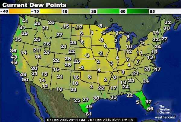
RECORDS. THOSE CURRENT DEWPOINTS IN THE LOWER TEENS ACROSS THE RED
RIVER VALLEY WILL BE OVER US BY THE MORNING SO THE FULL EFFECT OF
THIS AIR MASS UNDER WEAKENING NORTHEAST WINDS WILL BE FELT
THROUGHOUT THE DAY.

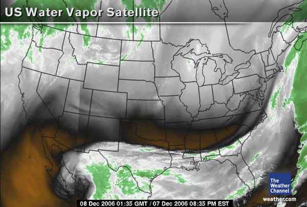
THIS WEEKEND`S WEATHER BECOMES MORE COMPLEX AS THE CURRENT BAJA
UPPER LOW OPENS INTO A WAVE OVER NORTHERN MEXICO. GFS SHOWS
SHORTWAVE ENERGY ROTATING IN ALONG THE COASTAL REGIONS THROUGH
SATURDAY. VORTS PASSING ON THROUGH IN PREDOMINANT W-SW FLOW WILL
HAVE LIMITED MOISTURE TO WORK WITH IN PRODUCING MUCH IN THE WAY OF
PRECIP. THE LONE EXCEPTION IS OVER MATAGORDA BAY AND SURROUNDING
COUNTIES WHERE RAIN CHANCES WILL BE HIGHER SIMPLY DUE TO THE FACT
OF HIGHER MOISTURE RETURN ON THOSE VEERING EASTERLY WINDS.

LONG RANGE PICTURE LOOKS WET WITH A THREAT FOR SEVERE WEATHER
TUESDAY. UPPER TROF OVER GREAT BASIN WITH ASSOCIATED DEEPENING
WESTERN GREAT PLAINS SURFACE TROF WILL INITIATE SUNDAY`S STRENGTHENING
ONSHORE FLOW. SUBSEQUENT WARM FRONT MOVING UP THE COAST LATE
SUNDAY INTO MONDAY WILL SIGNIFICANTLY INCREASE POPS. TOO FAR OUT
TO PEG A TIMING ON THE EVENTUAL CORE FRONT REACHING CENTRAL TEXAS
BUT CURRENT MODEL ENSEMBLE DOES POINT TOWARDS POSSIBLE SEVERE
WEATHER. LARGE SCALE DIVERGENCE WITH FAVORABLE RF QUAD JET
DYNAMICS IN A CONDITIONALLY UNSTABLE ENVIRONMENT WARRANTS MENTION
OF SEVERE ON TUESDAY.

The AFD mentions highs only in the mid to upper 40s tomorrow, yet the latest zone forecast says this:

Friday: Mostly sunny, with a high near 51. Northeast wind between 5 and 10 mph.

Does that make any sense to anyone else? I guess we will have to see what really happens, but either way it is going to be COLD!
Last edited by Extremeweatherguy on Sun Dec 17, 2006 1:36 pm, edited 5 times in total.
0 likes   

User avatar
jasons2k
Storm2k Executive
Storm2k Executive
Posts: 8245
Age: 51
Joined: Wed Jul 06, 2005 12:32 pm
Location: The Woodlands, TX

#2 Postby jasons2k » Thu Dec 07, 2006 4:33 pm

I dunno, this system is harder to forecast than the last one IMO. I don't see any chance for winter precip. for us but I am worried about tomorrow night. The speed of the high's translation SE will make all the difference. I really hope it can speed up some and we can avoid that 28F currently progged for my location....it's only the beginning of December and I've already had as many freezes as last year TOTAL....getting tired of this obscene cold in a hurry.
0 likes   

User avatar
gboudx
S2K Supporter
S2K Supporter
Posts: 4080
Joined: Thu Sep 04, 2003 1:39 pm
Location: Rockwall, Tx but from Harvey, La

#3 Postby gboudx » Thu Dec 07, 2006 5:51 pm

39 here with temp steadily falling. Dewpoint currently at 9. Gonna be a cold one tonight.
0 likes   

User avatar
wall_cloud
Professional-Met
Professional-Met
Posts: 401
Age: 48
Joined: Sun Dec 04, 2005 7:32 am
Location: Bartlett, TN
Contact:

Re: Texas Winter Weather Thread #3 - Cold snap to end the we

#4 Postby wall_cloud » Thu Dec 07, 2006 6:02 pm

Extremeweatherguy wrote:Latest Houston AFD contradicts their forecast for tomorrow:

The AFD mentions highs only in the mid to upper 40s tomorrow, yet the latest zone forecast says this:

Friday: Mostly sunny, with a high near 51. Northeast wind between 5 and 10 mph.

Does that make any sense to anyone else? I guess we will have to see what really happens, but either way it is going to be COLD!


if they are going 51 in Houston and at GLS, I would assume that much of the remainder of the area will be in the 40s. They don't just forecast for you guys in Houston and the AFD is a discussion about the entire forecast area.
0 likes   
My comments are my own and do not reflect those of NOAA or the National Weather Service.

User avatar
Extremeweatherguy
Category 5
Category 5
Posts: 11095
Joined: Mon Oct 10, 2005 8:13 pm
Location: Florida

#5 Postby Extremeweatherguy » Thu Dec 07, 2006 6:46 pm

Image

The main push of cold/dry air has not even reached SE Texas yet; It is still up in north Texas (but is quickly moving south). Notice the nearly 30-degree dewpoint difference between Houston and Dallas right now.
0 likes   

double D
Category 1
Category 1
Posts: 485
Joined: Wed Feb 15, 2006 8:17 pm
Location: Austin, Tx

#6 Postby double D » Thu Dec 07, 2006 8:26 pm

That is a cool map EWG. I like how it shows where the dry air is, notice that the dewpoints are much lower in the east (relatively speaking) than in the west this time around. It's not everyday that you see Dallas with a 20 degree lower dewpoint than Denver.
Last edited by double D on Thu Dec 07, 2006 8:28 pm, edited 1 time in total.
0 likes   

User avatar
weatherrabbit_tx
Category 1
Category 1
Posts: 270
Joined: Wed Dec 21, 2005 3:13 pm
Location: Kingwood,Tx
Contact:

#7 Postby weatherrabbit_tx » Thu Dec 07, 2006 8:26 pm

guess it will be here in the next couple of hours, so drier meaning colder :froze:
0 likes   

User avatar
Extremeweatherguy
Category 5
Category 5
Posts: 11095
Joined: Mon Oct 10, 2005 8:13 pm
Location: Florida

#8 Postby Extremeweatherguy » Thu Dec 07, 2006 9:14 pm

weatherrabbit_tx wrote:guess it will be here in the next couple of hours, so drier meaning colder :froze:
yes, it will be here soon. After it passes, our dew points and temperatures will fall rapidly. We should go from lower 50s this evening to around freezing by sunrise tomorrow.

BTW, here is a look at the current (8pm) Water Vapor image:

Image

It is very interesting, because it shows that even with a dewpoint of 2-degrees (as of the 8pm update at Love Field) Dallas still has a thick cloud deck just to it's south (and that deck almost seems to be holding it's own...or even perhaps creeping back north some). Also, that low over the baha looks to be gaining strength as it heads ENE.

This makes me wonder if tomorrow will be "mostly sunny" like the forecast says. I wouldn't be surprised to see us with mostly cloudy skies during a good part of the day with highs struggling to reach the middle 40s if this setup is still in place (the dry air looks to be undercutting the clouds with overrunning taking place over it).

I guess we will see what actually happens..

BTW: Here is a link to the full water vapor loop,

http://www.weather.com/maps/maptype/cur ... mated.html
0 likes   

User avatar
Extremeweatherguy
Category 5
Category 5
Posts: 11095
Joined: Mon Oct 10, 2005 8:13 pm
Location: Florida

#9 Postby Extremeweatherguy » Thu Dec 07, 2006 9:25 pm

AREA FORECAST DISCUSSION
NATIONAL WEATHER SERVICE HOUSTON/GALVESTON TX
819 PM CST THU DEC 7 2006

.DISCUSSION...
AT 01Z...STRONG HIGH PRESSURE WAS LOCATED OVER CENTRAL OKLAHOMA.
SURFACE DEW POINTS WERE IN THE SINGLE DIGITS OVER EXTREME NE TEXAS.
THESE VALUES WILL MODERATE SOME BUT SURFACE TRAJECTORIES SHOULD
BRING THIS DRIER AIR INTO SE TEXAS. NOT QUITE SURE...BUT THE 01Z
SURFACE CHART SHOWS SOME TYPE OF BOUNDARY FROM LCH TO IAH TO HDO.
DEW POINTS ARE ABOUT 10 DEGREES LOWER BEHIND THIS BOUNDARY AND THE
GRADIENT IS CONSIDERABLY TIGHTER (WINDS AT CLL 13G23). THAT
SAID...THINK CURRENT TEMP FORECAST IS ON THE MARK. DRIER AIR WILL
EVENTUALLY WORK INTO THE REGION WITH LOWER TEMPS BY MORNING. WINDS
SHOULD FULLY DECOUPLE INLAND AROUND MIDNIGHT. WILL TWEAK SKY GRIDS
AS CIRRUS SHIELD WILL CONTINUE TO SMOTHER SOUTHERN ZONES. MARINE
ZONES A BIT TRICKY. SUSTAINED WINDS ARE NOT ANYWHERE NEAR GALE
CRITERIA BUT WITH THIS SECOND SURGE OF COOLER AIR AND RESULTANT
GRADIENT...THINK GALE CONDITIONS COULD YET DEVELOP. DECISION ON
THE GALE WARNING WILL BE MADE RIGHT BEFORE ISSUANCE TIME. REST OF
THE FORECAST LOOKS OK. 43
0 likes   

User avatar
KatDaddy
Category 5
Category 5
Posts: 2815
Joined: Mon Oct 21, 2002 6:23 pm
Location: League City, Texas

#10 Postby KatDaddy » Thu Dec 07, 2006 9:38 pm

Looking at the WaterVapor tonight, this is how southern snowstorms occur. To bad its not January and 15F colder. It would really be interesting in the upcoming days.
0 likes   
The following post is NOT an official forecast and should not be used as such. It is just the opinion of the poster and may or may not be backed by sound meteorological data. It is NOT endorsed by any professional institution including storm2k.org For Official Information please refer to the NHC and NWS products.

User avatar
Yankeegirl
Category 5
Category 5
Posts: 3417
Age: 49
Joined: Sun May 23, 2004 11:59 pm
Location: Cy-Fair, Northwest Houston
Contact:

#11 Postby Yankeegirl » Thu Dec 07, 2006 9:39 pm

its chilly here too... 52.5 out and breezy...
0 likes   

double D
Category 1
Category 1
Posts: 485
Joined: Wed Feb 15, 2006 8:17 pm
Location: Austin, Tx

#12 Postby double D » Thu Dec 07, 2006 9:40 pm

I wonder if that precipitation in west Texas and Mexico will head towards central and southeast Texas overnight? If so, it will be interesting to see if some light freezing precipitation will form briefly in the early morning hours.
0 likes   

User avatar
CaptinCrunch
S2K Supporter
S2K Supporter
Posts: 8728
Age: 57
Joined: Mon Nov 03, 2003 4:33 pm
Location: Kennedale, TX (Tarrant Co.)

#13 Postby CaptinCrunch » Fri Dec 08, 2006 11:04 am

This was the coldest morning yet with a low of 17 at the house.
0 likes   

User avatar
gboudx
S2K Supporter
S2K Supporter
Posts: 4080
Joined: Thu Sep 04, 2003 1:39 pm
Location: Rockwall, Tx but from Harvey, La

#14 Postby gboudx » Fri Dec 08, 2006 11:08 am

Not sure at my house, but a personal weather station in my neighborhood shows 19 as the low.
0 likes   

Johnny
Category 5
Category 5
Posts: 1428
Joined: Thu Jul 10, 2003 1:35 pm
Location: No Snow For You, Texas

#15 Postby Johnny » Fri Dec 08, 2006 11:27 am

We got down to the forecasted 28 degrees here in Conroe. It really dropped off after midnight. It looks like it will be even colder tomorrow morning which is when I will be sitting in a deer stand. I think I'm gonna run and get me a propane heater!! lol
0 likes   

aggiecutter
Category 5
Category 5
Posts: 1753
Joined: Thu Oct 14, 2004 9:22 pm
Location: Texarkana

#16 Postby aggiecutter » Fri Dec 08, 2006 12:38 pm

Here in Texarkana we got down to 17 last night. Under clear skies at 11:00 o'clock, we are at 30 degrees.
0 likes   

User avatar
Yankeegirl
Category 5
Category 5
Posts: 3417
Age: 49
Joined: Sun May 23, 2004 11:59 pm
Location: Cy-Fair, Northwest Houston
Contact:

#17 Postby Yankeegirl » Fri Dec 08, 2006 12:42 pm

Didnt get that cold here in Houston, when I got the kids up for school this morning it was 36. From what I understand, we had some clouds and that kept it a few degrees warmer than expected... Clear and sunny out here now, and cold!! Hasnt gone up too much, its 41 out !!
0 likes   

User avatar
JenBayles
Category 5
Category 5
Posts: 3461
Age: 62
Joined: Tue Aug 26, 2003 3:27 pm
Location: Houston, TX
Contact:

#18 Postby JenBayles » Fri Dec 08, 2006 12:53 pm

Um... anyone watching that low to Houston's SW? Looks like we'll be at least cloudy tonite, so will the freeze be off?
0 likes   

User avatar
jasons2k
Storm2k Executive
Storm2k Executive
Posts: 8245
Age: 51
Joined: Wed Jul 06, 2005 12:32 pm
Location: The Woodlands, TX

#19 Postby jasons2k » Fri Dec 08, 2006 1:55 pm

Hey Jen, only had time to glace at things today but I'm not encouraged with a current temp. of 42 and a dewpoint of 8F - I just might be wrapping my tender palms tonight for the first time since the big scare last year. It'd be nice if the NWS would at least issue an updated AFD. All the other offices have - some 2 X since last night - but not Houston...
0 likes   

User avatar
JenBayles
Category 5
Category 5
Posts: 3461
Age: 62
Joined: Tue Aug 26, 2003 3:27 pm
Location: Houston, TX
Contact:

#20 Postby JenBayles » Fri Dec 08, 2006 2:07 pm

Hey schlitz! I gave up on trying to save all the greenery. Some things got to be too big to manage anyway and I'm past the point of worrying. I did manage to save my plumeria, but the rest can take their chances with a thorough watering.
:lol:
0 likes   


Return to “Winter Weather”

Who is online

Users browsing this forum: No registered users and 4 guests