Dennis obviously weakened quite a bit before landfall. Has there been any more research as to what the primary factor was? Would it be safer to say that no one factor played a greater role than others? I have read that eyewall replacement, shallow NGOM waters with less heat content, interaction of the circulation with the Northern Gulf Coast, and even the effect of Cindy a few days earlier churning up the water all played a role. Could anyone offer any more insight or direct me to any publication regarding this. I havent been able to find anything new in quite awhile....and thank goodness the season was a dud. I did not fire up the chainsaw or generator all summer!!!!
docjoe
question about Dennis 2005
Moderator: S2k Moderators
Forum rules

The posts in this forum are NOT official forecasts and should not be used as such. They are just the opinion of the poster and may or may not be backed by sound meteorological data. They are NOT endorsed by any professional institution or STORM2K. For official information, please refer to products from the National Hurricane Center and National Weather Service.
-
docjoe

- S2K Supporter

- Posts: 262
- Joined: Thu Sep 09, 2004 10:42 pm
- Location: SE Alabama..formerly the land of ivan and dennis
question about Dennis 2005
0 likes
-
Derek Ortt
most of the 2005 research that I am aware of is on Katrina and Rita (due to RAINEX for one).
I have not seen anything on Dennis, except for some model simulations by Dr Rob Rogers at HRD, but that is not about the hours before landfall.
There is also great uncertainty regarding Katrina's collapse just before landfall and the causes of it. EWRC though likely was not one of them (have been doing research on Katrina and Rita for more than a year and found no evidence)
0 likes

-
george_r_1961

- S2K Supporter
- Posts: 3171
- Age: 64
- Joined: Sat Oct 12, 2002 9:14 pm
- Location: Carbondale, Pennsylvania
Ptarmigan wrote:I have heard the reason why Katrina and Rita weakened is because of dry air entrapment.
That would be my guess. The convective features weakened in the hours before landfall, unfortunately not enough though to keep Katrina from being the most destructive storm to make US landfall in recent times.
0 likes
-
Derek Ortt
Rita did not weaken due to dry air entrainment. The data proves that statement beyond a shadow of a doubt. In fact the dropsonde data showed nearly saturated conditions in the outer rainbands
That is an example of some saying things without data to back them up. It leads to rumors about why something did something, and is is then reported by many others.
That is an example of some saying things without data to back them up. It leads to rumors about why something did something, and is is then reported by many others.
0 likes

Derek Ortt wrote:Rita did not weaken due to dry air entrainment. The data proves that statement beyond a shadow of a doubt. In fact the dropsonde data showed nearly saturated conditions in the outer rainbands
That is an example of some saying things without data to back them up. It leads to rumors about why something did something, and is is then reported by many others.
I remember exactly that a woman on The Weather Network TV (Canadian weather channel) said that Rita weakened because of dry air. So they jumped the gun? I can't count how many times TV has been wrong on these facts and figures.
So what caused Hurricane Rita to weaken then?
0 likes
-
Opal storm
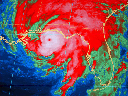
I'm obviously no expert but I would guess cooler and shallow waters just off the coast is what made Dennis weaken.IMO Dennis was actually pretty well organized at landfall,so I doubt dry air/wind shear was the cause.
http://cache.boston.com/bonzai-fba/AP_P ... 6_7986.jpg
http://cache.boston.com/bonzai-fba/AP_P ... 6_7986.jpg
0 likes
-
docjoe
- S2K Supporter
- Posts: 262
- Joined: Thu Sep 09, 2004 10:42 pm
- Location: SE Alabama..formerly the land of ivan and dennis
Opal storm wrote:I'm obviously no expert but I would guess cooler and shallow waters just off the coast is what made Dennis weaken.IMO Dennis was actually pretty well organized at landfall,so I doubt dry air/wind shear was the cause.
http://cache.boston.com/bonzai-fba/AP_P ... 6_7986.jpg
Dennis was well formed in that image. However it did have significant weakening very quickly. Only 4-6 hours prior to landfall it was still a strong Cat 4 at 145 MPH. To my untrained eye the link I am posting shows a landfalling TC with a disrupted eyewall. I guess maybe a better way to ask my original question would be to wonder if there is any new info as to why so many storms weaken in the NGOM just prior to landfall and if so can this be incorporated into forecasts the last few hours before landfall. Also why does the occasional storm like Frederic not have this significant weakening?
http://www.quehubo.com/eng/dennis_radar.html
docjoe
0 likes
-
Aslkahuna

- Professional-Met

- Posts: 4550
- Joined: Thu Feb 06, 2003 5:00 pm
- Location: Tucson, AZ
- Contact:
Depending upon the size and intensity (and thus organization) of the storm, land interaction during the final hours before landfall as the outer circulation moves onshore can weaken the storm by weakening the inflow and also interrupting the exchange of heat from the ocean to the storm (if you look at bouy data when a storm is over them you see invariably that the air temperature is cooler than the SST hence there is a net exchange of heat from the sea to the storm. In addtion cooling of shallow near shore water by mixing can also do the same. The more organized the storm, the more delicate it is and more susceptible to changes in the near and in storm environment. Land interaction is most observable when the terrain is mountainous but flat land can have a similar though slower effect. For example, much of coastal China north of the latitude of Taiwan is quite flat and yet we see weakening of storms approaching the coast even when they don't encounter any other land areas.
Steve
Steve
0 likes
-
Jim Cantore
Derek Ortt wrote:most of the 2005 research that I am aware of is on Katrina and Rita (due to RAINEX for one).
I have not seen anything on Dennis, except for some model simulations by Dr Rob Rogers at HRD, but that is not about the hours before landfall.
There is also great uncertainty regarding Katrina's collapse just before landfall and the causes of it. EWRC though likely was not one of them (have been doing research on Katrina and Rita for more than a year and found no evidence)
I read that Katrina started an EWRC without forming a new eyewall.
0 likes
-
Jim Cantore
-
HurricaneHunter914
- Category 5

- Posts: 4439
- Age: 32
- Joined: Fri Mar 10, 2006 7:36 pm
- Location: College Station, TX
How come this didn't happen to Wilma? Didn't she make landfall on the Gulf Coast too?
0 likes
Personal Forecast Disclaimer:
The posts in this forum are NOT official forecast and should not be used as such. They are just the opinion of the poster and may or may not be backed by sound meteorological data. They are NOT endorsed by any professional institution or storm2k.org. For official information, please refer to the NHC and NWS products.
The posts in this forum are NOT official forecast and should not be used as such. They are just the opinion of the poster and may or may not be backed by sound meteorological data. They are NOT endorsed by any professional institution or storm2k.org. For official information, please refer to the NHC and NWS products.
-
Derek Ortt
-
Aslkahuna
- Professional-Met
- Posts: 4550
- Joined: Thu Feb 06, 2003 5:00 pm
- Location: Tucson, AZ
- Contact:
Wilma over FL was getting the benefits of the dynamics associated with the trough the storm was tracking ahead of as well as benefitting from the outflow enhancement due to the westerlies north of the storm. A period of intensification of typhoons has been noted in the past during the period when the storms begin to track ahead of a front and also in the very early stages of the extratropical transition-this was studied by JTWC some years ago. This is the environment that Wilma was in.
Steve
Steve
0 likes
-
Derek Ortt
I have never seen an upper level environment as favorable as that experienced by Wilma. Everything was there for it to intensify quickly, and it sure took advantage of it, nearly reaching category 4 status.
That said, had the inner core not have collapsed over Cozumel, that thing probably would have struck as a 4 or a 5, and brought cat 3 winds into the center of Lauderdale, with borderline cat 1/2 winds into the center of Miami (Miami received low to mid cat 1 winds)
That said, had the inner core not have collapsed over Cozumel, that thing probably would have struck as a 4 or a 5, and brought cat 3 winds into the center of Lauderdale, with borderline cat 1/2 winds into the center of Miami (Miami received low to mid cat 1 winds)
0 likes
-
docjoe
- S2K Supporter
- Posts: 262
- Joined: Thu Sep 09, 2004 10:42 pm
- Location: SE Alabama..formerly the land of ivan and dennis
Derek Ortt wrote:I have never seen an upper level environment as favorable as that experienced by Wilma. Everything was there for it to intensify quickly, and it sure took advantage of it, nearly reaching category 4 status.
That said, had the inner core not have collapsed over Cozumel, that thing probably would have struck as a 4 or a 5, and brought cat 3 winds into the center of Lauderdale, with borderline cat 1/2 winds into the center of Miami (Miami received low to mid cat 1 winds)
Isnt it amazing how many close calls there have been recently with Cat 4 storms. Katrina, Rita, Wilma, Ivan, Dennis. They all had been at least Cat 4 and reasonably close to landfall as well...as close as a few hours in some cases. Scary thought
docjoe
0 likes
-
Jim Cantore
docjoe wrote:Derek Ortt wrote:I have never seen an upper level environment as favorable as that experienced by Wilma. Everything was there for it to intensify quickly, and it sure took advantage of it, nearly reaching category 4 status.
That said, had the inner core not have collapsed over Cozumel, that thing probably would have struck as a 4 or a 5, and brought cat 3 winds into the center of Lauderdale, with borderline cat 1/2 winds into the center of Miami (Miami received low to mid cat 1 winds)
Isnt it amazing how many close calls there have been recently with Cat 4 storms. Katrina, Rita, Wilma, Ivan, Dennis. They all had been at least Cat 4 and reasonably close to landfall as well...as close as a few hours in some cases. Scary thought
docjoe
Or in Katrinas case, a 5 within a few hours of landfall (up to 4 hours before I believe)
0 likes
-
Derek Ortt
it had weakened to a 4 by then per the best track. However, Katrina was in full Lili collapse mode on its approach. Unfortunately, it started at 150KT, not 125 like Lili did, which still resulted in cat 3 winds for Louisiana and a small part of Mississippi... and we all know the horrific results of that
0 likes
Who is online
Users browsing this forum: hurricanes1234, Steve and 35 guests