 The posts in this forum are NOT official forecast and should not be used as such. They are just the opinion of the poster and may or may not be backed by sound meteorological data. They are NOT endorsed by any professional institution or

Right now, it does not appear that there will be any episodes of sustained and meaningful blocking per the GFS ensembles. However, the ensembles have had widely varying situations, so my confidence is not all that high. What I do believe one will see is a PNA that approaches 0 and then perhaps winds ups weakly positive. The NAO could remain somewhat positive to near neutral. Overall, I don't expect troughs or ridges to lock into place in the Continental USA during most or all of the 12/1-7 timeframe.
The recent GSM idea is for much of the USA to see readings run somewhat below normal with the East winding up coolest relative to normal. However, the pattern marked by transient systems suggests that perhaps the GSM is overdone--at least if experience from past years is considered.
So, my thinking for the average temperature anomalies during the 12/1-7 period is as follows:
Average Regional Temperature Anomalies (12/1-7):
Northeast: Somewhat below normal to near normal
Mid-Atlantic: Below normal
Southeast: Below normal
Great Lakes: Near normal
Northern Plains: Above normal
Central Plains: Above normal
Southern Plains: Near normal to somewhat above normal
Pacific Northwest: Near normal to somewhat above normal
Southwest/Rest of West Coast: Above normal (but near normal in California)
For the major cities from Washington, DC to Boston, the 12/1-7 period is likely to feature:
- Nights generally in the 30s throughout the region with some 20s.
- Days mainly in the 50s in Philadelphia to Washington, DC, and 40s and 50s in New York City and Boston
- One or more days with a high temperature of 60° or above in Washington, DC
- One or more days with lows in the 20s throughout the region.
In the Southeast, Atlanta will likely see highs generally in the 50s with some 60s. However, a few days with highs only in the 40s may well occur.
At the same time, I believe the East Coast has potential to see at least a little snowfall in the big cities during the 12/1-10 period (first week is favored).
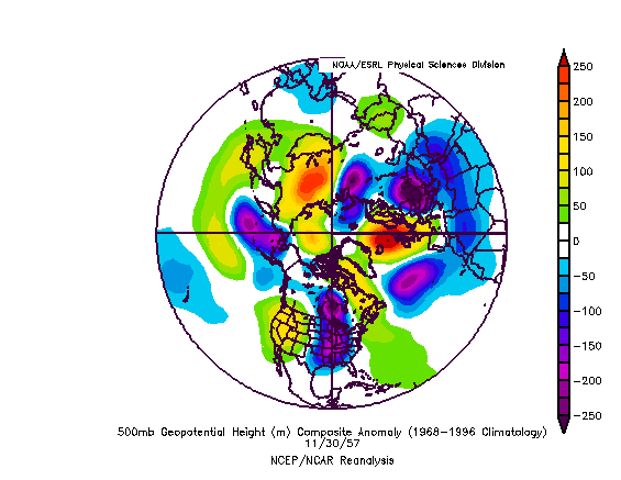
While the past is no guarantee of the future, the forecast GFS ensemble mean 500 mb height anomalies for 11/30 0z is remarkably similar to those that were present on 11/30/1957. Ultimately, after a brief warm shot, a storm brough a significant snowfall to parts of the East Coast on December 3-4.
GFS Ensembles: Forecast 500 mb height anomalies for 11/30/2006 0z:

500 mb Height Anomalies for November 30, 1957:
All said, especially as past patterns similar to the current one have seen at least one big qpf event and frequent smaller ones, the idea that perhaps some precipitation occurs when it is sufficiently cold is not outlandish. Some earlier runs of the GFS had indicated snowfall potential.
Given the warm November, December's total snowfall in such cities as Washington, DC (if 6" or more falls), New York City (if 8" or more falls) or Boston (if 15" or more falls) could offer a critical signal as to whether an above to much above normal season lies ahead. Low snowfall could indicate below normal snowfall, especially for NYC or Washington, DC.


