Here's an exciting (for me anyway) excerpt from the Jackson, MS AFD:
I HAVE STAYED A BIT CONSERVATIVE WITH THE LOWS AT THIS TIME...MAINLY DUE TO A BIT OF UNCERTAINTY WITH TIMING I STILL HAVE. HOWEVER...LATEST ENSEMBLE DATA SUGGEST THAT
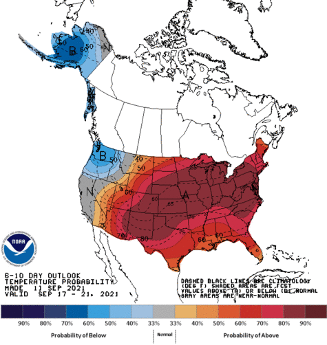
THIS WILL BE THE MOST SIGNIFICANT COLD AIRMASS WE HAVE SEEN SO FAR THIS SEASON. H5 HEIGHT ANOMALIES ARE RUNNING -3 STANDARD DEV AND THE H85 TEMP ANOMALIES ARE -3 TO -4! IF THIS PANS OUT LIKE THE ENSEMBLE DATA SUGGESTS...40-45 DEGREES MAY BE WIDESPREAD FRI MORNING. HIGHS ON FRI ARE ALSO SUSPECT AND I HAVE TRENDED DOWNWARD A TAD.
That wouldn't be absurd for this area, but it would be about 10 degrees below typical late September/early October lows which typically run in the lower 50s. I can't wait. I hope it's a sign of things to come this winter. Some white stuff and a few mornings in the teens would be nice this winter. Here in Canton, MS (about 15 miles north of Jackson), we average a one inch snowfall every 2.5 years and a 3 inch + snowfall every four years according to NWS (
http://www.srh.noaa.gov/jan/winter_climatology.htm) . We've had traces in the last few years, but we're overdue for accumulation!
 The posts in this forum are NOT official forecast and should not be used as such. They are just the opinion of the poster and may or may not be backed by sound meteorological data. They are NOT endorsed by any professional institution or