Area of Weather over Eastern GOM
Moderator: S2k Moderators
Forum rules

The posts in this forum are NOT official forecasts and should not be used as such. They are just the opinion of the poster and may or may not be backed by sound meteorological data. They are NOT endorsed by any professional institution or STORM2K. For official information, please refer to products from the National Hurricane Center and National Weather Service.

Area of Weather over Eastern GOM
So, is there nay possibility this can form, i dont see any swirls or anything, its just that there is a lot of thunderstorms and it is hurricane season...If someone can please post a pic. I cannot im on a public PC, Any input?
0 likes


Area of weather over S. Fla. and Bahamas...
Rain, rain, rain here in S. Fla. since Thursday. It's wonderful! 
0 likes
Area over Bahamas, S. Fla....
So much rain in S. Fla, and then the sun shines through, and there have been double rainbows the past 2 days. Beautiful!
0 likes

Wow Florida sure has got it's share of supprizes this year so far. Makes me way to nervous... Though things have been some what kinda slow that scares me that there might be somthing way more critical coming up. Seems like sometimes when things are slow, it makes you wonder whats in store and just around the corner...
0 likes

-
Hyperstorm

- Category 5

- Posts: 1500
- Joined: Sun Sep 07, 2003 3:48 am
- Location: Ocala, FL
I would say one thing:
Watch it.
I've seen many times when the tail end of a transitioning tropical cyclone develops into a low pressure area a couple of days after the cyclone departs. This one has the look of one that will try to bust western Atlantic conditions if allowed.
Gulf Stream boost near Miami today with a new record...
0 likes


-
HurricaneGirl

- Category 5
- Posts: 5839
- Age: 61
- Joined: Thu Feb 06, 2003 9:45 am
- Location: Clare, Michigan
- Contact:
Re: Area over Bahamas, S. Fla....
Awesome! Did you get any pictures sunnyday??sunnyday wrote:So much rain in S. Fla, and then the sun shines through, and there have been double rainbows the past 2 days. Beautiful!
0 likes

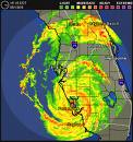
Boy...looking at radar is is lining up on us in SoFla for a heck of a storm....arrrrggghhhh
AREA FORECAST DISCUSSION
NATIONAL WEATHER SERVICE MIAMI FL
1011 AM EDT SUN SEP 3 2006
.UPDATE...THE ATMOSPHERE REMAINS MOIST AND UNSTABLE THIS
MORNING....WITH PRECIPITABLE WATER NEAR 2 INCHES. IT IS NOT QUITE
AS UNSTABLE AS YESTERDAY...WITH SLIGHT MID LEVEL WARMING (H5 TEMP
AT -6.7C) AND LOW LEVEL COOLING...SO THERE IS LESS CAPE. THERE IS
ALSO MORE DRIER AIR IN PLACE JUST ABOVE THE SURFACE...BUT NOT THAT
DRY. HOWEVER...I THINK THERE WILL BE BETTER CONVERGENCE ACROSS THE
AREA THIS AFTERNOON. A SCATTEROMTER PASS SHOWS A WELL DEFINED
CONVERGENCE LINE SET UP FROM NEAR GRAND BAHAMA ISLAND STRETCHING
SOUTHWEST AND PROBABLY NOW LIES ACROSS SE MIAMI-DADE COUNTY (GIVEN
THAT FOWEY IS REPORTING SE WINDS NOW). GFS IS VERY BULLISH ON
HEAVY RAINFALL TAKING PLACE ACROSS THE EAST COAST METRO AREAS THIS
AFTERNOON...DEVELOPING ALONG THIS CONVERGENCE BOUNDARY (STORMS
HAVE ALREADY FORMED ALONG IT OVER THE ATLANTIC)...AND THIS SEEMS
PLAUSIBLE...MORESO THAN THE WRF WHICH SHOWS ALMOST NO ACTIVITY
TODAY. WILL HAVE TO WATCH OUT FOR HEAVY RAINFALL IN SLOW MOVING
THUNDERSTORMS THIS AFTERNOON. BELIEVE HEAVIEST RAIN WILL OCCUR
ACROSS THE EAST COAST METRO AREAS...AND SO WILL INCREASE THE QPF FOR
THESE AREAS TOWARDS HPC GUIDANCE - NEAR AN INCH AREA WIDE.
SHOWERS/STORMS HAVE FORMED OVER THE NEAR SHORE GULF WATERS THIS
MORNING...AND A WEST FLOW ACROSS THE GULF/INTERIOR SHOULD ALLOW
THIS ACTIVITY TO MOVE/DEVELOP INLAND. SO WILL MAINTAIN VERY HIGH
POPS FOR THIS AFTERNOON...AND NO SIGNIFICANT CHANGES WILL BE MADE
TO THE FCST. /GREGORIA
0 likes
-
Hyperstorm
- Category 5
- Posts: 1500
- Joined: Sun Sep 07, 2003 3:48 am
- Location: Ocala, FL
-
Stormavoider
- Category 2

- Posts: 671
- Joined: Sat Jul 01, 2006 4:37 pm
- Location: Spring Hill Fl.
http://wwwghcc.msfc.nasa.gov/cgi-bin/get-goes?satellite=GOES-E%20CONUS&lat=26&lon=-81&map=latlon&info=vis&zoom=1&width=2800&height=2000&type=Animation&numframes=5&palette=ir.pal
Some turning this morning over Okeechobee. It's not upper level. At least I don't think it is. There is no indication of turning there on WV.
Some turning this morning over Okeechobee. It's not upper level. At least I don't think it is. There is no indication of turning there on WV.
0 likes
Who is online
Users browsing this forum: Team Ghost and 61 guests