
Central Atlantic Wave,Midway Between Africa and L Antilles
Moderator: S2k Moderators
Forum rules

The posts in this forum are NOT official forecasts and should not be used as such. They are just the opinion of the poster and may or may not be backed by sound meteorological data. They are NOT endorsed by any professional institution or STORM2K. For official information, please refer to products from the National Hurricane Center and National Weather Service.
-
cycloneye

- Admin

- Posts: 148763
- Age: 69
- Joined: Thu Oct 10, 2002 10:54 am
- Location: San Juan, Puerto Rico
0 likes
Visit the Caribbean-Central America Weather Thread where you can find at first post web cams,radars
and observations from Caribbean basin members Click Here
and observations from Caribbean basin members Click Here
-
ConvergenceZone
.gif)
- Category 5

- Posts: 5241
- Joined: Fri Jul 29, 2005 1:40 am
- Location: Northern California
-
Extremeweatherguy

- Category 5
- Posts: 11095
- Joined: Mon Oct 10, 2005 8:13 pm
- Location: Florida
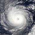
yes, persistance is the key. As we have seen many times this year, these waves can seem to go "poof" at the blink of an eye.ConvergenceZone wrote:CrazyC83 wrote:ConvergenceZone wrote:Extremeweatherguy wrote:this one looks impressive!
The question now will be...how long does it take to develop? If it can't get going before 50W, then it may make it into the Caribbean, and if it does get going before 50W, then it will likely be a fish or east coast storm.
Fish storms are fun as long as they develop well(unlike boring Debbie).
From birth to buzzsaw yep, that's what I want to see....
Debby may have played a role in clearing a lot of the Saharan dust...
Yea, that's a good point. The SAL is extremely dimished compared to what it was earlier. Perhaps that's why this wave has got it going so quickly. This is the first wave where convection has blown up THIS quick.
I don't want to say too much though, as we'll have to see if it will sustain itself.
0 likes
-
HurricaneMaster_PR

- Category 2

- Posts: 795
- Joined: Tue Jul 22, 2003 6:23 pm
- Location: San Juan, Puerto Rico
-
calculatedrisk
- Tropical Depression

- Posts: 76
- Joined: Fri Jul 15, 2005 3:39 pm
Extremeweatherguy wrote: As we have seen many times this year, these waves can seem to go "poof" at the blink of an eye.
Yes, but most of the waves went "poof" between 20W and 30W. This wave is getting stronger at 30W.
On page 2, I posted a Sat image of the then future Ernesto at about 40W - it was just starting to reappear. That wave was fairly impressive when it exited Africa, and then mostly disappeared (or was buried in the ITCZ) until 40W.
This wave seems much more impressive.
0 likes
-
ConvergenceZone
- Category 5
- Posts: 5241
- Joined: Fri Jul 29, 2005 1:40 am
- Location: Northern California
calculatedrisk wrote:Extremeweatherguy wrote: As we have seen many times this year, these waves can seem to go "poof" at the blink of an eye.
Yes, but most of the waves went "poof" between 20W and 30W. This wave is getting stronger at 30W.
On page 2, I posted a Sat image of the then future Ernesto at about 40W - it was just starting to reappear. That wave was fairly impressive when it exited Africa, and then mostly disappeared (or was buried in the ITCZ) until 40W.
This wave seems much more impressive.
Yea, that's a good point, and this has come along way just since today.
0 likes

-
Extremeweatherguy
- Category 5
- Posts: 11095
- Joined: Mon Oct 10, 2005 8:13 pm
- Location: Florida
After Florence will be Gordon.ConvergenceZone wrote:Extremeweatherguy wrote:Here is a look at the steering flow over the next 2 days:
Initial - http://www.nco.ncep.noaa.gov/pmb/nwprod ... _000.shtml
Ridge to the north should keep it on a westward path for tonight.
24 hrs. - http://www.nco.ncep.noaa.gov/pmb/nwprod ... _024.shtml
Wave should continue west.
48 hrs. - http://www.nco.ncep.noaa.gov/pmb/nwprod ... _048.shtml
Wave signiture looks to be right east of the leeward islands and the ridge should continue to push this west.
Based on this I think a rapid motion W or WNW should be the case over the next 48 hrs. Beyond 48 hrs. it should slow down with a less certain path. I will be watching this one for sure..
Thanx Extreme for posting these...What name is after Florence by the way?
0 likes
-
Extremeweatherguy
- Category 5
- Posts: 11095
- Joined: Mon Oct 10, 2005 8:13 pm
- Location: Florida
oh, and I completely agree. I just do not want to get overly exited in this one just to watch it fall apart like Chris and to some extent Ernesto (as well as the countless invests). I am trying to learn by the many lessons of 2006. If this can hold it's own for the next 12-24 hrs. though, then I agree..the will be GAME ON! IMO, I think this has a pretty good chance of becoming Florence at some point in it's life.calculatedrisk wrote:Extremeweatherguy wrote: As we have seen many times this year, these waves can seem to go "poof" at the blink of an eye.
Yes, but most of the waves went "poof" between 20W and 30W. This wave is getting stronger at 30W.
On page 2, I posted a Sat image of the then future Ernesto at about 40W - it was just starting to reappear. That wave was fairly impressive when it exited Africa, and then mostly disappeared (or was buried in the ITCZ) until 40W.
This wave seems much more impressive.
0 likes
-
ConvergenceZone
- Category 5
- Posts: 5241
- Joined: Fri Jul 29, 2005 1:40 am
- Location: Northern California
guys, what's that feature just above this wave(to the north northwest) ? Will that feature shear the storm or keep it moving westward? What type of impact do you think that will have? I haven't looked at the maps yet, as my computer's having ab it of a problem right now...Just look at the satellite luis posted or the link below.... There's obviously a feature just to the northwest of the wave...
http://www.ssd.noaa.gov/goes/east/catl/avn.jpg
http://www.ssd.noaa.gov/goes/east/catl/avn.jpg
0 likes
-
emeraldislencguy
- S2K Supporter

- Posts: 207
- Joined: Sun Aug 27, 2006 4:35 pm
- Location: emerald isle nc
- Contact:
nice looking wave
this is one of the most impressive ones of the year--an invest should be up in 24 hours
0 likes

-
bostonseminole

- Tropical Storm

- Posts: 209
- Joined: Sun Sep 11, 2005 3:54 pm
- Location: Tokyo, Japan
ConvergenceZone wrote:guys, what's that feature just above this wave(to the north northwest) ? Will that feature shear the storm or keep it moving westward? What type of impact do you think that will have? I haven't looked at the maps yet, as my computer's having ab it of a problem right now...Just look at the satellite luis posted or the link below.... There's obviously a feature just to the northwest of the wave...
http://www.ssd.noaa.gov/goes/east/catl/avn.jpg
That's a surface low that has been tracked all the way from the African coast. It's embedded in very dry air and has no hope of developing in the short term. I guess development would be possible further west in a more moist environment if it can attain some convection, but this scenario does not have any model support.
0 likes
-
HurricaneMaster_PR
- Category 2
- Posts: 795
- Joined: Tue Jul 22, 2003 6:23 pm
- Location: San Juan, Puerto Rico
TROPICAL WEATHER OUTLOOK
NWS TPC/NATIONAL HURRICANE CENTER MIAMI FL
1030 PM EDT MON AUG 28 2006
FOR THE NORTH ATLANTIC...CARIBBEAN SEA AND THE GULF OF MEXICO...
THE NATIONAL HURRICANE CENTER IS ISSUING ADVISORIES ON TROPICAL
STORM ERNESTO...LOCATED ABOUT 20 MILES NORTH OF CAMAGUEY CUBA.
AN AREA OF SHOWERS AND THUNDERSTORMS...ASSOCIATED WITH A TROPICAL
WAVE...IS LOCATED ABOUT 600 MILES SOUTHWEST OF THE CAPE VERDE
ISLANDS. DEVELOPMENT...IF ANY...IS EXPECTED TO BE SLOW TO OCCUR.
ELSEWHERE...TROPICAL STORM FORMATION IS NOT EXPECTED THROUGH
WEDNESDAY.
0 likes
-
jhamps10
HurricaneMaster_PR wrote:
AN AREA OF SHOWERS AND THUNDERSTORMS...ASSOCIATED WITH A TROPICAL
WAVE...IS LOCATED ABOUT 600 MILES SOUTHWEST OF THE CAPE VERDE
ISLANDS. DEVELOPMENT...IF ANY...IS EXPECTED TO BE SLOW TO OCCUR.
ELSEWHERE...TROPICAL STORM FORMATION IS NOT EXPECTED THROUGH
WEDNESDAY.
I'm sorry, but this thing is developing very strong convection some grays on the IR sat. I do not agree with NHC, I think that this will develop a little bit faster than they think. Just look at it over this evening, That's all I got to say on this one.
0 likes
Who is online
Users browsing this forum: No registered users and 89 guests