Yes looking at the low level steering flow it appears that it would move SW, if any convection would pop up with this thing.
Looking at the CIMSS site, it appears there maybe a little more convergence in the lower levels for some convection to fire up today.
http://cimss.ssec.wisc.edu/tropic/real- ... 8conv.html
805TWD - TPC
...DISCUSSION...
THE GULF OF MEXICO...
SHORTWAVE IR IMAGERY SHOWS A COUPLE LOW TO MID LEVEL CYCLONIC
CIRCULATIONS IN THE CENTRAL GULF...WITH THE MOST OBVIOUS NEAR
25N87W. BUOY OBS ALSO NOW SHOW CLEAR CYCLONIC TURNING AND
CONFLUENCE IN THE CENTRAL GULF WHICH HAS LEAD TO THE TROUGH
PLACEMENT ON THE INTERMEDIATE 16/0900 UTC MAP. SCATTERED SHOWERS
AND TSTMS ARE NOTED FROM 23N TO 29W BETWEEN 86W AND 93W. THESE
SHOWERS/TSTMS ARE MOVING NE TO SW BETWEEN AN UPPER HIGH NEAR SRN
ARKANSAS AND THE UPPER LOW JUST N OF TAMPA. UPPER DIFFLUENCE
BETWEEN THESE FEATURES IS HELPING THE CLUSTER OF MODERATE
CONVECTION SEEN S OF THE CENTRAL LOUISIANA COAST NEAR 28N91W.
SHELL PLATFORM 42362 IS IN THIS VICINITY AND SHOWED THAT 30KT
ENE WINDS MIXED DOWN AT 0800 UTC. DOPPLER RADAR ALSO SHOWS
SCATTERED SHOWERS AND TSTMS JUST OFFSHORE FT MYERS...ASSOCIATED
WITH INSTABILITY AROUND THE BASE OF THE UPPER LOW. 16/0000 UTC
GFS SEEMS TO HAVE THIS HANDLED WELL...SHOWING A DISTINCT REGION
OF 500MB POSITIVE VORTICITY ADVECTION IN THE REGION WHERE THE
SHOWERS ARE OCCURRING OFF W FLORIDA. MUCH OF THE WRN GULF
BETWEEN 93W AND 98W IS UNDER THE INFLUENCE OF DRY AIR AND FAIR
WEATHER. SYNOPTIC SURFACE PATTERN IN THE GULF IS IN A VERY WEAK
PRESSURE PATTERN AT THE MOMENT.
If anything were to happen it better happen quick before any surface features are not around anymore.
GOM System (Ex 95L)
Moderator: S2k Moderators
Forum rules

The posts in this forum are NOT official forecasts and should not be used as such. They are just the opinion of the poster and may or may not be backed by sound meteorological data. They are NOT endorsed by any professional institution or STORM2K. For official information, please refer to products from the National Hurricane Center and National Weather Service.
-
SouthFloridawx

- S2K Supporter

- Posts: 8346
- Age: 47
- Joined: Tue Jul 26, 2005 1:16 am
- Location: Sarasota, FL
- Contact:


-
SouthFloridawx
- S2K Supporter
- Posts: 8346
- Age: 47
- Joined: Tue Jul 26, 2005 1:16 am
- Location: Sarasota, FL
- Contact:
NAM fairly bullish on development with this Invest,
http://moe.met.fsu.edu/cyclonephase/nam ... 606/3.html
Nogaps still seeing some potential
http://moe.met.fsu.edu/cyclonephase/ngp ... 00/55.html
http://moe.met.fsu.edu/cyclonephase/nam ... 606/3.html
Nogaps still seeing some potential
http://moe.met.fsu.edu/cyclonephase/ngp ... 00/55.html
0 likes
-
Portastorm

- Storm2k Moderator

- Posts: 9918
- Age: 63
- Joined: Fri Jul 11, 2003 9:16 am
- Location: Round Rock, TX
- Contact:
-
jasons2k

- Storm2k Executive

- Posts: 8252
- Age: 52
- Joined: Wed Jul 06, 2005 12:32 pm
- Location: The Woodlands, TX
Portastorm wrote:(sigh) ...
I'd like something of a rain-producing sort (even a strong tropical wave) to start cooking in the Gulf. I just looked over the Euro and GFS and the Western Sizzler High doesn't appear to be going anywhere anytime soon. Triple-digit highs are getting common here ... too common!
Unfortunately, it looks like you are exactly right:
AREA FORECAST DISCUSSION
NATIONAL WEATHER SERVICE CORPUS CHRISTI TX
252 PM CDT WED AUG 16 2006
.SHORT TERM (TONIGHT THROUGH THURSDAY NIGHT)...CLIMATOLOGY FAVORS
THE GFS/UKMET SOLUTIONS IN NOT RECEDING THE MID-LEVEL ANTICYCLONE
SO FAST. CONSEQUENTLY...TUTT FEATURE AND ANY SURFACE REFLECTION
OVER THE GLFMEX WILL BE BLOCKED/WEAKENED WITH SUBSIDENT REGIME
LEADING TO MOSTLY CLEAR SKIES.
0 likes

-
Extremeweatherguy

- Category 5

- Posts: 11095
- Joined: Mon Oct 10, 2005 8:13 pm
- Location: Florida
-
Matt-hurricanewatcher
-
Stratosphere747
- Category 5
- Posts: 3772
- Joined: Thu Sep 11, 2003 8:34 pm
- Location: Surfside Beach/Freeport Tx
- Contact:
Extremeweatherguy wrote:JB says that he thinks this looks better tonight than last night. He said that pressures are falling around the circulation and all that needs to happen is for convection to fire around it. He thinks it will then track into S. Texas.
Which circulation? And how is this better than last night? Besides the convection over Louisiana, there is nothing in the GOM.
0 likes


Stratosphere747 wrote:Extremeweatherguy wrote:JB says that he thinks this looks better tonight than last night. He said that pressures are falling around the circulation and all that needs to happen is for convection to fire around it. He thinks it will then track into S. Texas.
Which circulation? And how is this better than last night? Besides the convection over Louisiana, there is nothing in the GOM.
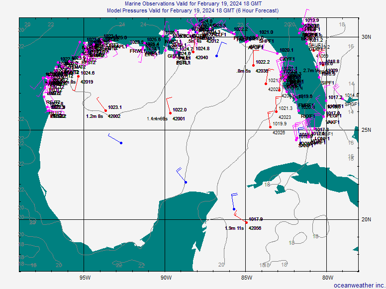
There is a weak loosely defined circulation out in the mid Gulf centered around 26/88.
http://www.oceanweather.com/data/Gulf-o ... ineM00.gif
Also shows up on the shortwave IR.
http://www.ssd.noaa.gov/goes/east/gmex/loop-ir2.html
Pressures are 2-3mb lower than they were at the same time last night.
The convection over Louisiana is not related.
Last edited by teal61 on Wed Aug 16, 2006 9:22 pm, edited 1 time in total.
0 likes
-
Stormcenter
- S2K Supporter
- Posts: 6687
- Joined: Wed Sep 03, 2003 11:27 am
- Location: Houston, TX
teal61 wrote:Stratosphere747 wrote:Extremeweatherguy wrote:JB says that he thinks this looks better tonight than last night. He said that pressures are falling around the circulation and all that needs to happen is for convection to fire around it. He thinks it will then track into S. Texas.
Which circulation? And how is this better than last night? Besides the convection over Louisiana, there is nothing in the GOM.
There is a weak loosely defined circulation out in the mid Gulf centered around 26/88.
http://www.oceanweather.com/data/Gulf-o ... ineM00.gif
Also shows up on the shortwave IR.
http://www.ssd.noaa.gov/goes/east/gmex/loop-ir2.html
The convection over Louisiana is not related.
Thanks for posting that.
0 likes
-
Stratosphere747
- Category 5
- Posts: 3772
- Joined: Thu Sep 11, 2003 8:34 pm
- Location: Surfside Beach/Freeport Tx
- Contact:
-
Extremeweatherguy
- Category 5
- Posts: 11095
- Joined: Mon Oct 10, 2005 8:13 pm
- Location: Florida
Last night that loose circulation had pressures 2-3mb higher, so that means it has deepened some. JB said that the convection over LA is not associated with this system.Stratosphere747 wrote:Thanks for the obs and images....
The only thing that looks remotely close to last night is convection over a landmass *Louisiana*
And somehow we are looking for organization? Still not sure what JB is tracking into S. Texas.....
0 likes
Extremeweatherguy wrote:Last night that loose circulation had pressures 2-3mb higher, so that means it has deepened some. JB said that the convection over LA is not associated with this system.Stratosphere747 wrote:Thanks for the obs and images....
The only thing that looks remotely close to last night is convection over a landmass *Louisiana*
And somehow we are looking for organization? Still not sure what JB is tracking into S. Texas.....
Kinda funny.. Tim Heller of CH 13 did a "special " report at the begining of the 10pm news on that weak low in the Gulf.
Like he said though, as long as it's out there and the water temps are as warm as they are we have to keep an eye on it.
0 likes