http://www.ssd.noaa.gov/PS/TROP/DATA/RT/WATL/IR4/20.jpg
That is related to a weak low pressure that came out of southamerica and a tropical wave in that area.But the shear continues to be unfavorable although we have to watch the area that is in the western caribbean as it is in a favored area this time of the season.Also watch it because the canadian model showed something comming out of the caribbean sea in past runs but other models have not done anything with it.
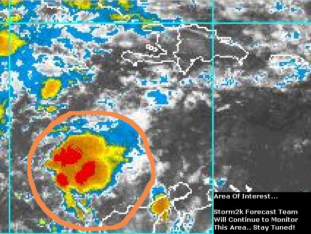
Tropical wave in westcentral caribbean flaring up
Moderator: S2k Moderators
Forum rules

The posts in this forum are NOT official forecasts and should not be used as such. They are just the opinion of the poster and may or may not be backed by sound meteorological data. They are NOT endorsed by any professional institution or STORM2K. For official information, please refer to products from the National Hurricane Center and National Weather Service.
-
cycloneye

- Admin

- Posts: 149727
- Age: 69
- Joined: Thu Oct 10, 2002 10:54 am
- Location: San Juan, Puerto Rico
Tropical wave in westcentral caribbean flaring up
0 likes
Visit the Caribbean-Central America Weather Thread where you can find at first post web cams,radars
and observations from Caribbean basin members Click Here
and observations from Caribbean basin members Click Here
-
wx247

- S2K Supporter

- Posts: 14279
- Age: 42
- Joined: Wed Feb 05, 2003 10:35 pm
- Location: Monett, Missouri
- Contact:
Yes, there is a thunderstorm development here this morning. It is hugging the coastline and I don't see any development from this, at least not in the next 24 hours.
0 likes
Personal Forecast Disclaimer:
The posts in this forum are NOT official forecast and should not be used as such. They are just the opinion of the poster and may or may not be backed by sound meteorological data. They are NOT endorsed by any professional institution or storm2k.org. For official information, please refer to the NHC and NWS products.
The posts in this forum are NOT official forecast and should not be used as such. They are just the opinion of the poster and may or may not be backed by sound meteorological data. They are NOT endorsed by any professional institution or storm2k.org. For official information, please refer to the NHC and NWS products.
-
Toni - 574

- Category 1

- Posts: 493
- Joined: Wed May 28, 2003 9:20 pm
- Location: W. Central Florida
Here is the model takes this morning:
The CMC 00z run has an area of disturbed weather crossing over the Yucatan and into the BOC at 120 hrs.
The Nogaps 00z run has an area of disturbed weather at the tip of the E. Yucatan coast @84 hrs. and then making a B-line to the SW central Fla. Coast in about 120 hrs.
The 06-GFS run Initializes disturbance at 006 hrs and by 60 hrs. it is sitting at the tip of W. Cuba, then by 108 hrs. crossing over SW Coast of Central Fla.
Looks like we have a few models that are picking up on the same area. Let’s see if it persists. Definitely something to keep a close eye on. Especially in that area this time of year.
Toni
0 likes
-
therock1811

- Category 5

- Posts: 5163
- Age: 40
- Joined: Thu May 15, 2003 2:15 pm
- Location: Kentucky
- Contact:
This is from the TPC:
ABNT20 KNHC 141510
TWOAT
TROPICAL WEATHER OUTLOOK
NWS TPC/NATIONAL HURRICANE CENTER MIAMI FL
1130 AM EDT SAT JUN 14 2003
FOR THE NORTH ATLANTIC...CARIBBEAN SEA AND THE GULF OF MEXICO...
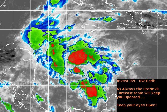
THE TROPICAL WAVE LOCATED IN THE CENTRAL CARIBBEAN SEA A COUPLE OF
DAYS AGO HAS MOVED SLOWLY WESTWARD AND IS NOW OVER THE WESTERN
CARIBBEAN. SATELLITE IMAGES AND SURFACE OBSERVATIONS INDICATE THAT
A BROAD AREA OF LOW PRESSURE ASSOCIATED WITH THE WAVE HAS FORMED
ABOUT 375 MILES SOUTH-SOUTHEAST OF GRAND CAYMAN AND IS ACCOMPANIED
BY A LARGE AREA OF CLOUDINESS AND THUNDERSTORMS. BECAUSE THE
UPPER-LEVEL WINDS ARE FORECAST TO BECOME FAVORABLE FOR
DEVELOPMENT...THERE IS A POTENTIAL FOR A TROPICAL DEPRESSION TO
FORM IN THE NEXT DAY OR TWO AS THE SYSTEM MOVES TOWARD THE
NORTHWEST.
ELSEWHERE...TROPICAL STORM FORMATION IS NOT EXPECTED THROUGH SUNDAY.
ABNT20 KNHC 141510
TWOAT
TROPICAL WEATHER OUTLOOK
NWS TPC/NATIONAL HURRICANE CENTER MIAMI FL
1130 AM EDT SAT JUN 14 2003
FOR THE NORTH ATLANTIC...CARIBBEAN SEA AND THE GULF OF MEXICO...
THE TROPICAL WAVE LOCATED IN THE CENTRAL CARIBBEAN SEA A COUPLE OF
DAYS AGO HAS MOVED SLOWLY WESTWARD AND IS NOW OVER THE WESTERN
CARIBBEAN. SATELLITE IMAGES AND SURFACE OBSERVATIONS INDICATE THAT
A BROAD AREA OF LOW PRESSURE ASSOCIATED WITH THE WAVE HAS FORMED
ABOUT 375 MILES SOUTH-SOUTHEAST OF GRAND CAYMAN AND IS ACCOMPANIED
BY A LARGE AREA OF CLOUDINESS AND THUNDERSTORMS. BECAUSE THE
UPPER-LEVEL WINDS ARE FORECAST TO BECOME FAVORABLE FOR
DEVELOPMENT...THERE IS A POTENTIAL FOR A TROPICAL DEPRESSION TO
FORM IN THE NEXT DAY OR TWO AS THE SYSTEM MOVES TOWARD THE
NORTHWEST.
ELSEWHERE...TROPICAL STORM FORMATION IS NOT EXPECTED THROUGH SUNDAY.
0 likes
-
southerngale

- Retired Staff

- Posts: 27418
- Joined: Thu Oct 10, 2002 1:27 am
- Location: Southeast Texas (Beaumont area)
Hmmm....maybe I'll turn out to be right after all. Last night in chat I said that I thought we'd have a named storm within 2 weeks, but I was just trying to be optimistic. 
I didn't think there would be something to watch this morning!
I didn't think there would be something to watch this morning!
0 likes
Please support Storm2k by making a donation today. It is greatly appreciated! Click here: 
 my Cowboys my Rockets my Astros
my Cowboys my Rockets my Astros-
cycloneye
- Admin
- Posts: 149727
- Age: 69
- Joined: Thu Oct 10, 2002 10:54 am
- Location: San Juan, Puerto Rico
Hummmmmmm you see what the tropics bring sometimes SURPRISES!!!!.I posted this thread this morning about the shear there but it has decreased now and I never thinked an invest would be up but there it is and now really we have to watch this area. :o
0 likes
Visit the Caribbean-Central America Weather Thread where you can find at first post web cams,radars
and observations from Caribbean basin members Click Here
and observations from Caribbean basin members Click Here
-
ColdFront77
I have been commenting on the low wind shear over the eastern Gulf of Mexico, which has actually been decreasing since (at least) yesterday. So, this area of convection in the southwestern Caribbean has potential with the favorable area, warm sea surface temperatures and the shear decreasing as Luis mentioned.
0 likes
Who is online
Users browsing this forum: South Texas Storms, Ulf and 135 guests