MJO
Moderator: S2k Moderators
Forum rules

The posts in this forum are NOT official forecasts and should not be used as such. They are just the opinion of the poster and may or may not be backed by sound meteorological data. They are NOT endorsed by any professional institution or STORM2K. For official information, please refer to products from the National Hurricane Center and National Weather Service.
Although I have no concrete stats to analyze, my own recall suggests to me that the reliability of this indicator has been seemingly unimpressive during the last couple of years, the time that I've followed it to any extent. So, I personally won't put too much stock in this indicator until an objective analysis based on a sufficiently long enough period tells me there is a decent correlation, if it ever suggests this.
0 likes
Personal Forecast Disclaimer:
The posts in this forum are NOT official forecasts and should not be used as such. They are just the opinion of the poster and may or may not be backed by sound meteorological data. They are NOT endorsed by any professional institution or storm2k.org. For official information, please refer to the NHC and NWS products.
The posts in this forum are NOT official forecasts and should not be used as such. They are just the opinion of the poster and may or may not be backed by sound meteorological data. They are NOT endorsed by any professional institution or storm2k.org. For official information, please refer to the NHC and NWS products.

-
Derek Ortt
-
Derek Ortt
Derek Ortt wrote:that articvle shows a very nice coorelation between GOM hurricanes and the MJO. Definately has anb impact on GOM hurricanes. I am now convinced of that after reading this study
What about the rest of the Atlantic? Any clear correlations?
0 likes
Personal Forecast Disclaimer:
The posts in this forum are NOT official forecasts and should not be used as such. They are just the opinion of the poster and may or may not be backed by sound meteorological data. They are NOT endorsed by any professional institution or storm2k.org. For official information, please refer to the NHC and NWS products.
The posts in this forum are NOT official forecasts and should not be used as such. They are just the opinion of the poster and may or may not be backed by sound meteorological data. They are NOT endorsed by any professional institution or storm2k.org. For official information, please refer to the NHC and NWS products.
-
SouthFloridawx

- S2K Supporter

- Posts: 8346
- Age: 47
- Joined: Tue Jul 26, 2005 1:16 am
- Location: Sarasota, FL
- Contact:
People should not be letting thier guards down. Just as you can be in an Wet Phase of MJO it looks like we are in the opposite right now. The MJO is starting to slowly creap into the EPAC. They will be the next ones to get things fired up and it will steadily move eastward towards our basin.
No reason for people to think the season is dead. It'll catch you by suprise when you least expect it.


No reason for people to think the season is dead. It'll catch you by suprise when you least expect it.
0 likes
-
Extremeweatherguy

- Category 5

- Posts: 11095
- Joined: Mon Oct 10, 2005 8:13 pm
- Location: Florida
-
cycloneye

- Admin

- Posts: 148763
- Age: 69
- Joined: Thu Oct 10, 2002 10:54 am
- Location: San Juan, Puerto Rico
Yep,just in time for the peak of the season,the wet phase of the MJO will arrive in the Atlantic.And all those posts about =Season is dead,It's boring,shear is everywhere etc,etc,etc will be a thing of the past.Fasten your seatbelts my friends from late August.
0 likes
Visit the Caribbean-Central America Weather Thread where you can find at first post web cams,radars
and observations from Caribbean basin members Click Here
and observations from Caribbean basin members Click Here
-
Extremeweatherguy
- Category 5
- Posts: 11095
- Joined: Mon Oct 10, 2005 8:13 pm
- Location: Florida
-
'CaneFreak

- Category 5
- Posts: 1487
- Joined: Mon Jun 05, 2006 10:50 am
- Location: New Bern, NC
cycloneye wrote:Yep,just in time for the peak of the season,the wet phase of the MJO will arrive in the Atlantic.And all those posts about =Season is dead,It's boring,shear is everywhere etc,etc,etc will be a thing of the past.Fasten your seatbelts my friends from late August.
Yep because the area of subsidence is decreasing and now it appears that the wet phase of the MJO is knocking at the door of the Atlantic....Get ready for a wild ride!!! The next few weeks are going to make or break this hurricane season and make it a memorable season one way or another....
0 likes

-
SouthFloridawx
- S2K Supporter
- Posts: 8346
- Age: 47
- Joined: Tue Jul 26, 2005 1:16 am
- Location: Sarasota, FL
- Contact:
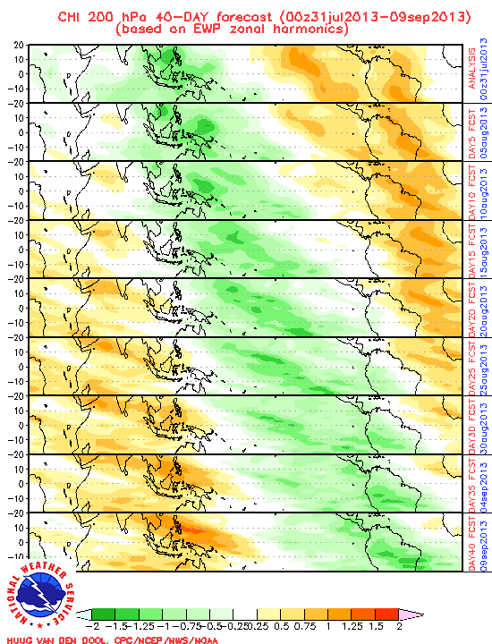
GFS week 1 forecast
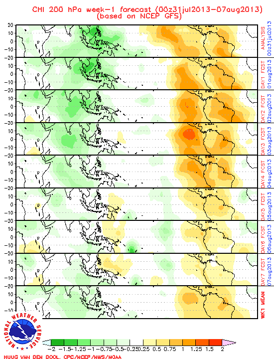
GFS week 2 forecast
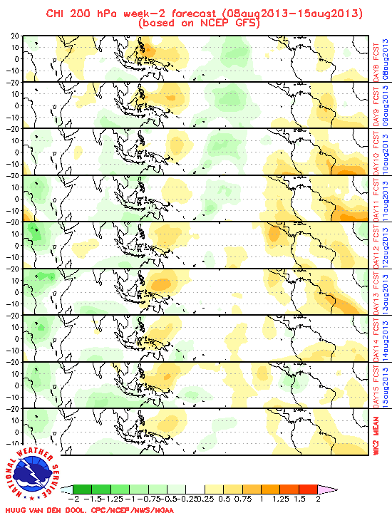
15 Day forecast.
This was the EWP forecast.
http://www.cpc.ncep.noaa.gov/products/p ... JO/ewp.gif
GFS week 2 forecast
15 Day forecast.
This was the EWP forecast.
http://www.cpc.ncep.noaa.gov/products/p ... JO/ewp.gif
0 likes
-
Jim Hughes
- Category 3

- Posts: 825
- Joined: Sun Jul 24, 2005 1:52 pm
- Location: Martinsburg West Virginia
clfenwi wrote:It's an old study (the data covers 1947-1997) but I'm not aware of anything more recent:
Maloney, E. D., and D. L. Hartmann, 2000:
Modulation of Hurricane activity in the Gulf of Mexico
by the Madden-Julian Oscillation. Science., 287, 2002-
2004.
I recall reading this article years ago. It was good and it had forecasting value.
0 likes
-
Extremeweatherguy
- Category 5
- Posts: 11095
- Joined: Mon Oct 10, 2005 8:13 pm
- Location: Florida


-
Extremeweatherguy
- Category 5
- Posts: 11095
- Joined: Mon Oct 10, 2005 8:13 pm
- Location: Florida


hcane27 wrote:It probably won't make it into the Atlantic with any signifcant impact .... should very weak ....
Actually, the MJO has a modulating impact on TCs in all basins. The MJO signal circumnavigates the tropics most clearly in the 200mb velocity potential anomalies.
http://www.cpc.ncep.noaa.gov/products/p ... thly.shtml
http://www.cpc.ncep.noaa.gov/products/i ... tlon.shtml
Negative anomalies are more favorable for TC genesis.
There's a really good COMET tutorial on the MJO presented by Dr. Roland Madden himself. There's a bit on the association of the MJO and TC genesis.
http://meted.ucar.edu/climate/mjo/
0 likes

hcane27 wrote:It probably won't make it into the Atlantic with any signifcant impact .... should very weak ....
Can you delete that post please? That is a odd comment with something that has a huge effect on tropical cyclones and development of tropical cyclones. The MJO has been a key player IMO.
0 likes
Who is online
Users browsing this forum: No registered users and 70 guests