The Wave SW of Cape Verde Islands
Moderator: S2k Moderators
Forum rules

The posts in this forum are NOT official forecasts and should not be used as such. They are just the opinion of the poster and may or may not be backed by sound meteorological data. They are NOT endorsed by any professional institution or STORM2K. For official information, please refer to products from the National Hurricane Center and National Weather Service.


-
JonathanBelles
- Professional-Met

- Posts: 11430
- Age: 35
- Joined: Sat Dec 24, 2005 9:00 pm
- Location: School: Florida State University (Tallahassee, FL) Home: St. Petersburg, Florida
- Contact:
-
Matt-hurricanewatcher
Yes but not likely to happen since Chris is a goner...
Looking at this system there appears to be a broad low level flow(LLC) most likely monsoonal in nature. Theres a buoy at 34/35 west 13 north which has a northwest winds. Which shows it...ALso take a look at the cloud motion. I think a LLC maybe trying to close off where that area of convection is firing near 10.5 north/31 west. See when you get convection over a broad LLC/monsoonal system like this you trend to close it off near the convection. Also notice at 15 north see the stratocu that is dry air. Which doe's not look like it is getting into it yet. So a cyclone maybe forming at 10.5/31.
http://www.cira.colostate.edu/ramm/rmsd ... PICAL.html
0 likes
-
SouthFloridawx

- S2K Supporter

- Posts: 8346
- Age: 47
- Joined: Tue Jul 26, 2005 1:16 am
- Location: Sarasota, FL
- Contact:
Yeah I think we may have something here in the very near future if the convection can continue flaring.
At first I was looking at the CIMSS site and noticed a lot of shear going on there. But, then I decided to look to 200mb analysis and noticed that the shear was not moving towards the convection but, away from the convection.
This is creating a good upper level divergent outflow for the convection that is blowing up tonight.
200mb analysis

http://www.nhc.noaa.gov/tafb/QHQA17.jpg
850mb analysis
http://www.nhc.noaa.gov/tafb/QUNA00.jpg
Then I wanted to check the 850mb analysis and we see low level vorticity going on there also and maybe some low pressure trying to develop.
This is also shown very well on the CIMSS site here with the upper level divergence and lower level convergence graphics, from the University of Wisconsin.


850mb Vorticity

Also the E. Atlantic is in a Wet MJO phase as evidence here.

I think we're going to see some development out of the Eastern Atlantic sooner than we think.
As long as convection persists and we have good upper and lower level conditions there is no reason why this area should not develop eventually.
At first I was looking at the CIMSS site and noticed a lot of shear going on there. But, then I decided to look to 200mb analysis and noticed that the shear was not moving towards the convection but, away from the convection.
This is creating a good upper level divergent outflow for the convection that is blowing up tonight.
200mb analysis
http://www.nhc.noaa.gov/tafb/QHQA17.jpg
850mb analysis
http://www.nhc.noaa.gov/tafb/QUNA00.jpg
Then I wanted to check the 850mb analysis and we see low level vorticity going on there also and maybe some low pressure trying to develop.
This is also shown very well on the CIMSS site here with the upper level divergence and lower level convergence graphics, from the University of Wisconsin.
850mb Vorticity
Also the E. Atlantic is in a Wet MJO phase as evidence here.
I think we're going to see some development out of the Eastern Atlantic sooner than we think.
As long as convection persists and we have good upper and lower level conditions there is no reason why this area should not develop eventually.
Last edited by SouthFloridawx on Sat Aug 05, 2006 2:18 pm, edited 2 times in total.
0 likes


-
SouthFloridawx
- S2K Supporter
- Posts: 8346
- Age: 47
- Joined: Tue Jul 26, 2005 1:16 am
- Location: Sarasota, FL
- Contact:


000
ABNT20 KNHC 050851
TWOAT
TROPICAL WEATHER OUTLOOK
NWS TPC/NATIONAL HURRICANE CENTER MIAMI FL
530 AM EDT SAT AUG 5 2006
FOR THE NORTH ATLANTIC...CARIBBEAN SEA AND THE GULF OF MEXICO...
THE NATIONAL HURRICANE CENTER HAS ISSUED THE LAST ADVISORY ON
WEAKENING TROPICAL DEPRESSION CHRIS...LOCATED ABOUT 150 MILES EAST
OF CAMAGUEY CUBA.
TROPICAL STORM FORMATION IS NOT EXPECTED THROUGH SUNDAY.
$$
FORECASTER AVILA
Last edited by mobilebay on Sat Aug 05, 2006 4:42 am, edited 1 time in total.
0 likes


Blob watch # 256 here:
http://www.nrlmry.navy.mil/sat-bin/disp ... C_SCALE=15
Nice one about to roll off of Africa.
One of these days ONE of these might actually develop!
http://www.nrlmry.navy.mil/sat-bin/disp ... C_SCALE=15
Nice one about to roll off of Africa.
One of these days ONE of these might actually develop!
0 likes
-
SouthFloridawx
- S2K Supporter
- Posts: 8346
- Age: 47
- Joined: Tue Jul 26, 2005 1:16 am
- Location: Sarasota, FL
- Contact:

http://www.ssd.noaa.gov/goes/east/catl/loop-rgb.html
000
ABNT20 KNHC 051517
TWOAT
TROPICAL WEATHER OUTLOOK
NWS TPC/NATIONAL HURRICANE CENTER MIAMI FL
1130 AM EDT SAT AUG 5 2006
A BROAD AREA OF DISTURBED WEATHER IS LOCATED ABOUT 590 MILES
SOUTHWEST OF THE CAPE VERDE ISLANDS. SOME SLOW DEVELOPMENT OF THIS
SYSTEM IS POSSIBLE OVER THE NEXT COUPLE DAYS AS IT MOVES SLOWLY
WESTWARD.
ELSEWHERE...TROPICAL STORM FORMATION IS NOT EXPECTED THROUGH SUNDAY.
$$
FORECASTER BROWN/BEVEN
Last edited by SouthFloridawx on Sat Aug 05, 2006 2:19 pm, edited 1 time in total.
0 likes
-
SouthFloridawx
- S2K Supporter
- Posts: 8346
- Age: 47
- Joined: Tue Jul 26, 2005 1:16 am
- Location: Sarasota, FL
- Contact:

http://bricker.met.psu.edu/~arnottj/cgi ... =Animation
The Canadian is now keying in on the area and not the area to the east around 52 W or so as mentioned in the TWD yesterday.
0 likes
-
SouthFloridawx
- S2K Supporter
- Posts: 8346
- Age: 47
- Joined: Tue Jul 26, 2005 1:16 am
- Location: Sarasota, FL
- Contact:
000
AXNT20 KNHC 051745
TWDAT
TROPICAL WEATHER DISCUSSION
NWS TPC/NATIONAL HURRICANE CENTER MIAMI FL
205 PM EDT SAT AUG 05 2006
...TROPICAL WAVES...
A TROPICAL WAVE IS ADDED ALONG 31W/32W BASED ON SATELLITE
IMAGERY AND SURFACE DATA. A BROAD AND ELONGATED AREA OF LOW
PRESSURE IS BECOMING MORE EVIDENT ALONG THE WAVE AXIS NEAR 11N.
SOME SLOW DEVELOPMENT OF THIS SYSTEM IS POSSIBLE OVER THE NEXT
COUPLE DAYS AS IT MOVES SLOWLY WESTWARD. MOST OF THE SCATTERED
MODERATE CONVECTION ASSOCIATED WITH THIS DISTURBED WEATHER IS
WITHIN THE ITCZ FROM 7N-11N BETWEEN 25W-38W.
0 likes
-
calculatedrisk
- Tropical Depression

- Posts: 76
- Joined: Fri Jul 15, 2005 3:39 pm

-
SouthFloridawx
- S2K Supporter
- Posts: 8346
- Age: 47
- Joined: Tue Jul 26, 2005 1:16 am
- Location: Sarasota, FL
- Contact:
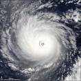
You can see a very broad and very large area of low pressure going on out there. This will end up being a large storm. It is moving very very slowly at the west and should be reinforced by the latest wave that came off of Africa.
http://www.ssd.noaa.gov/goes/east/catl/loop-rgb.html
Well taking a look at the situation this afternoon I really think there is a good possiblity we'll be seeing our next invest tomorrow out of this area. There is still a very broad area of good convection firing. Upper level divergence is getting better and the is a lot of lower level convergence going on.
200mb Wind Analysis
http://www.nhc.noaa.gov/tafb/QHQA17.jpg
You can see the divergent upper level winds very clearly on that graphic.
850mb Wind Analysis
http://www.nhc.noaa.gov/tafb/QUNA00.jpg
You can see the low level convergence associated with this broad area.
Here are the visual graphics for what i'm talking about.


I see no reason why this shouldn't be our first cape verde storm this year. I have been wrong before though so ...

http://www.ssd.noaa.gov/goes/east/catl/loop-rgb.html
Well taking a look at the situation this afternoon I really think there is a good possiblity we'll be seeing our next invest tomorrow out of this area. There is still a very broad area of good convection firing. Upper level divergence is getting better and the is a lot of lower level convergence going on.
200mb Wind Analysis
http://www.nhc.noaa.gov/tafb/QHQA17.jpg
You can see the divergent upper level winds very clearly on that graphic.
850mb Wind Analysis
http://www.nhc.noaa.gov/tafb/QUNA00.jpg
You can see the low level convergence associated with this broad area.
Here are the visual graphics for what i'm talking about.
I see no reason why this shouldn't be our first cape verde storm this year. I have been wrong before though so ...
0 likes
-
SouthFloridawx
- S2K Supporter
- Posts: 8346
- Age: 47
- Joined: Tue Jul 26, 2005 1:16 am
- Location: Sarasota, FL
- Contact:
-
willjnewton
-
SouthFloridawx
- S2K Supporter
- Posts: 8346
- Age: 47
- Joined: Tue Jul 26, 2005 1:16 am
- Location: Sarasota, FL
- Contact:
willjnewton wrote:is the wave off of africa that the national hurricane center is talking about getting better organized???
It's the one that is sw of the cape verde islands. If you click on the the link below you'll see where it is every clearly.
http://www.ssd.noaa.gov/goes/east/catl/loop-rgb.html
0 likes
-
SouthFloridawx
- S2K Supporter
- Posts: 8346
- Age: 47
- Joined: Tue Jul 26, 2005 1:16 am
- Location: Sarasota, FL
- Contact:

-
cycloneye

- Admin

- Posts: 148772
- Age: 69
- Joined: Thu Oct 10, 2002 10:54 am
- Location: San Juan, Puerto Rico
By looking at that loop it's clearly evident the circulation albeit a broad one.
0 likes
Visit the Caribbean-Central America Weather Thread where you can find at first post web cams,radars
and observations from Caribbean basin members Click Here
and observations from Caribbean basin members Click Here
Who is online
Users browsing this forum: South Texas Storms and 84 guests