MJO

This is the general tropical discussion area. Anyone can take their shot at predicting a storms path.

Moderator: S2k Moderators

Forum rules

The posts in this forum are NOT official forecasts and should not be used as such. They are just the opinion of the poster and may or may not be backed by sound meteorological data. They are NOT endorsed by any professional institution or STORM2K. For official information, please refer to products from the National Hurricane Center and National Weather Service.

Help Support Storm2K
Message
Author
User avatar
cycloneye
Admin
Admin
Posts: 146154
Age: 69
Joined: Thu Oct 10, 2002 10:54 am
Location: San Juan, Puerto Rico

#41 Postby cycloneye » Tue Jul 11, 2006 6:34 pm

Derek Ortt wrote:and may not have a strong effect for the Atlntic, like the Pacific.

I remember that was one point of contention during my trop met class in spring of 2005


Derek,do you think MJO is more weak this year and not have a big influence?
0 likes   
Visit the Caribbean-Central America Weather Thread where you can find at first post web cams,radars
and observations from Caribbean basin members Click Here

User avatar
cycloneye
Admin
Admin
Posts: 146154
Age: 69
Joined: Thu Oct 10, 2002 10:54 am
Location: San Juan, Puerto Rico

#42 Postby cycloneye » Fri Jul 14, 2006 12:39 pm

Image

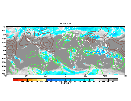
The wet phase of MJO has arrived for the most part in the Atlantic Basin.But still the core of this wet phase is in the EPAC.
0 likes   
Visit the Caribbean-Central America Weather Thread where you can find at first post web cams,radars
and observations from Caribbean basin members Click Here

User avatar
gatorcane
S2K Supporter
S2K Supporter
Posts: 23693
Age: 47
Joined: Sun Mar 13, 2005 3:54 pm
Location: Boca Raton, FL

#43 Postby gatorcane » Fri Jul 14, 2006 12:49 pm

cycloneye wrote:Image

The wet phase of MJO has arrived for the most part in the Atlantic Basin.But still the core of this wet phase is in the EPAC.


Luis, do you think we'll start seeing more shower/thunderstorm activity in the Atlantic now that the MJO wet phase has arrived? If so when?
0 likes   

User avatar
Extremeweatherguy
Category 5
Category 5
Posts: 11095
Joined: Mon Oct 10, 2005 8:13 pm
Location: Florida

#44 Postby Extremeweatherguy » Fri Jul 14, 2006 1:52 pm

Once that core of the wet phase reaches the Atlantic I think the tropics are going to erupt.
0 likes   

User avatar
cycloneye
Admin
Admin
Posts: 146154
Age: 69
Joined: Thu Oct 10, 2002 10:54 am
Location: San Juan, Puerto Rico

#45 Postby cycloneye » Fri Jul 14, 2006 1:52 pm

gatorcane wrote:
cycloneye wrote:Image

The wet phase of MJO has arrived for the most part in the Atlantic Basin.But still the core of this wet phase is in the EPAC.


Luis, do you think we'll start seeing more shower/thunderstorm activity in the Atlantic now that the MJO wet phase has arrived? If so when?


In a couple of weeks you will see a change in the Atlantic to more favorable conditions as this wet phase pulse enters completly the Atlantic.
0 likes   
Visit the Caribbean-Central America Weather Thread where you can find at first post web cams,radars
and observations from Caribbean basin members Click Here

User avatar
Extremeweatherguy
Category 5
Category 5
Posts: 11095
Joined: Mon Oct 10, 2005 8:13 pm
Location: Florida

#46 Postby Extremeweatherguy » Fri Jul 14, 2006 1:53 pm

cycloneye wrote:
gatorcane wrote:
cycloneye wrote:Image

The wet phase of MJO has arrived for the most part in the Atlantic Basin.But still the core of this wet phase is in the EPAC.


Luis, do you think we'll start seeing more shower/thunderstorm activity in the Atlantic now that the MJO wet phase has arrived? If so when?


In a couple of weeks you will see a change in the Atlantic to more favorable conditions as this wet phase pulse enters completly the Atlantic.
yeah, and this is why I think in 8-12 days we are going to see a major upswing in Atlantic development.
0 likes   

HurricaneHunter914
Category 5
Category 5
Posts: 4439
Age: 31
Joined: Fri Mar 10, 2006 7:36 pm
Location: College Station, TX

#47 Postby HurricaneHunter914 » Fri Jul 14, 2006 1:54 pm

When you say a couple of weeks do you mean August?
0 likes   
Personal Forecast Disclaimer:
The posts in this forum are NOT official forecast and should not be used as such. They are just the opinion of the poster and may or may not be backed by sound meteorological data. They are NOT endorsed by any professional institution or storm2k.org. For official information, please refer to the NHC and NWS products.

User avatar
cycloneye
Admin
Admin
Posts: 146154
Age: 69
Joined: Thu Oct 10, 2002 10:54 am
Location: San Juan, Puerto Rico

#48 Postby cycloneye » Fri Jul 14, 2006 1:59 pm

HurricaneHunter914 wrote:When you say a couple of weeks do you mean August?


Look at calender of July and see when it will be a couple of weeks from today. :)
0 likes   
Visit the Caribbean-Central America Weather Thread where you can find at first post web cams,radars
and observations from Caribbean basin members Click Here

User avatar
gatorcane
S2K Supporter
S2K Supporter
Posts: 23693
Age: 47
Joined: Sun Mar 13, 2005 3:54 pm
Location: Boca Raton, FL

#49 Postby gatorcane » Fri Jul 14, 2006 4:56 pm

cycloneye wrote:
HurricaneHunter914 wrote:When you say a couple of weeks do you mean August?


Look at calender of July and see when it will be a couple of weeks from today. :)


I'd have to agree with your assessment. I have been predicting our next TD which will form into a TS will form sometime around Aug 1st +/- 5 days...

that puts us about 2 weeks out until we see any significant development
0 likes   

User avatar
Extremeweatherguy
Category 5
Category 5
Posts: 11095
Joined: Mon Oct 10, 2005 8:13 pm
Location: Florida

#50 Postby Extremeweatherguy » Fri Jul 14, 2006 8:51 pm

18Z GFS is showing tons of moisture in the Gulf starting on day 5:

http://www.nco.ncep.noaa.gov/pmb/nwprod ... _120.shtml

The moisture then works toward the northern and western Gulf by day 7:

http://www.nco.ncep.noaa.gov/pmb/nwprod ... _168.shtml

And heavy rains look likely for much of the Gulf by day 9:

http://www.nco.ncep.noaa.gov/pmb/nwprod ... _216.shtml

We will have to watch and see if anything tropical comes out of this mess.
0 likes   

HurricaneHunter914
Category 5
Category 5
Posts: 4439
Age: 31
Joined: Fri Mar 10, 2006 7:36 pm
Location: College Station, TX

#51 Postby HurricaneHunter914 » Fri Jul 14, 2006 11:46 pm

So far this year the GFS has shown alot of possible TCs forming but so far only Alberto was the only right one.
0 likes   
Personal Forecast Disclaimer:
The posts in this forum are NOT official forecast and should not be used as such. They are just the opinion of the poster and may or may not be backed by sound meteorological data. They are NOT endorsed by any professional institution or storm2k.org. For official information, please refer to the NHC and NWS products.

User avatar
skysummit
S2K Supporter
S2K Supporter
Posts: 5305
Age: 49
Joined: Tue Aug 31, 2004 11:09 pm
Location: Ponchatoula, LA
Contact:

#52 Postby skysummit » Sat Jul 15, 2006 4:19 am

HurricaneHunter914 wrote:So far this year the GFS has shown alot of possible TCs forming but so far only Alberto was the only right one.


Too bad the GFS didn't show Alberto until the last minute though. Only the Canadian and NAM showed Alberto.
0 likes   

User avatar
cycloneye
Admin
Admin
Posts: 146154
Age: 69
Joined: Thu Oct 10, 2002 10:54 am
Location: San Juan, Puerto Rico

#53 Postby cycloneye » Sun Jul 16, 2006 7:00 pm

Not quite yet,the core of the wet phase of MJO has arrived in the Atlantic.Still that core is in the EPAC where it has been very active as Bud,Carlotta formed with this wet phase there.Right now two disturbances are organizing into cyclones in that basin.
0 likes   
Visit the Caribbean-Central America Weather Thread where you can find at first post web cams,radars
and observations from Caribbean basin members Click Here

User avatar
SouthFloridawx
S2K Supporter
S2K Supporter
Posts: 8346
Age: 46
Joined: Tue Jul 26, 2005 1:16 am
Location: Sarasota, FL
Contact:

#54 Postby SouthFloridawx » Mon Jul 17, 2006 6:30 pm

cycloneye wrote:Image

The wet phase of MJO has arrived for the most part in the Atlantic Basin.But still the core of this wet phase is in the EPAC.


Well I certainly see why there see's to be more convection in the Caribbean as Wet MJO is probably involved here.
Image

Also I have read here at storm2k that wet MJO causes more rising air eliminaing that Mid to upper level windshear... as indicated with the Shear Tendency Map here at CIMSS in the Southwestern Caribbean.

http://cimss.ssec.wisc.edu/tropic/real- ... 8sht-1.GIF
0 likes   

HurricaneHunter914
Category 5
Category 5
Posts: 4439
Age: 31
Joined: Fri Mar 10, 2006 7:36 pm
Location: College Station, TX

#55 Postby HurricaneHunter914 » Mon Jul 17, 2006 7:55 pm

If you look at the MJO map, it seems like the wet MJO is decreasing as it moves into the Atlantic.
0 likes   
Personal Forecast Disclaimer:
The posts in this forum are NOT official forecast and should not be used as such. They are just the opinion of the poster and may or may not be backed by sound meteorological data. They are NOT endorsed by any professional institution or storm2k.org. For official information, please refer to the NHC and NWS products.

User avatar
cycloneye
Admin
Admin
Posts: 146154
Age: 69
Joined: Thu Oct 10, 2002 10:54 am
Location: San Juan, Puerto Rico

#56 Postby cycloneye » Thu Jul 20, 2006 8:58 pm

Mike Watkins will talk about MJO at show.It has arrived partially in the Atlantic.

http://www.icess.ucsb.edu/asr/MJO/MJO.forecast.olr.png
0 likes   
Visit the Caribbean-Central America Weather Thread where you can find at first post web cams,radars
and observations from Caribbean basin members Click Here

JonathanBelles
Professional-Met
Professional-Met
Posts: 11430
Age: 35
Joined: Sat Dec 24, 2005 9:00 pm
Location: School: Florida State University (Tallahassee, FL) Home: St. Petersburg, Florida
Contact:

#57 Postby JonathanBelles » Thu Jul 20, 2006 9:07 pm

when did the last wave go thru?
0 likes   

JonathanBelles
Professional-Met
Professional-Met
Posts: 11430
Age: 35
Joined: Sat Dec 24, 2005 9:00 pm
Location: School: Florida State University (Tallahassee, FL) Home: St. Petersburg, Florida
Contact:

#58 Postby JonathanBelles » Thu Jul 20, 2006 9:09 pm

im still not sure if i get the mjo
0 likes   

User avatar
'CaneFreak
Category 5
Category 5
Posts: 1487
Joined: Mon Jun 05, 2006 10:50 am
Location: New Bern, NC

#59 Postby 'CaneFreak » Sat Jul 22, 2006 10:26 am

looks as though the dry phase is trying to set up again....wow..ugh..
0 likes   

hcane27
Tropical Storm
Tropical Storm
Posts: 231
Joined: Tue Jan 31, 2006 7:33 pm

MJO drying out

#60 Postby hcane27 » Sat Jul 22, 2006 11:10 am

It is not unusual for the MJO to "dry" as it enters the Atlantic basin. This one appears to be no different than "usual". Impact and influence likely to be minimal, but I didn't say none, just not explosive.
0 likes   


Return to “Talkin' Tropics”

Who is online

Users browsing this forum: duilaslol and 41 guests