The parade has started
Moderator: S2k Moderators
Forum rules

The posts in this forum are NOT official forecasts and should not be used as such. They are just the opinion of the poster and may or may not be backed by sound meteorological data. They are NOT endorsed by any professional institution or STORM2K. For official information, please refer to products from the National Hurricane Center and National Weather Service.
-
cheezyWXguy

- Category 5

- Posts: 6242
- Joined: Mon Feb 13, 2006 12:29 am
- Location: Dallas, TX
-
x-y-no

- Category 5
- Posts: 8359
- Age: 65
- Joined: Wed Aug 11, 2004 12:14 pm
- Location: Fort Lauderdale, FL
Derek Ortt wrote:what has been observed regarding the SAL is kind of the opposite. The leading wave is not the sacrifice, but the trailing wave is. It has been pointed out to me that a trailing wave blocks the SAL, allowing the leading wave to develop (which makes sense, since the SAL overtakes from the rear
Interesting ...
I'll watch for that phenomenon.
0 likes
-
whereverwx
- Category 5
- Posts: 1109
- Joined: Mon May 31, 2004 10:15 pm

-
Jim Cantore
george_r_1961 wrote:And we are gonna watch these waves go poof as soon as they hit the water. Agreed things are becoming more active but development out there is rare in July..and yes I say this on the 10th anniversary of Big Bertha..a CV storm..hitting NC
Most of these impressive clusters vanish when they hit water, but some like Jeanne in 1998 dont, in fact she was a depression when she hit water.
0 likes
Hurricane Floyd wrote:george_r_1961 wrote:And we are gonna watch these waves go poof as soon as they hit the water. Agreed things are becoming more active but development out there is rare in July..and yes I say this on the 10th anniversary of Big Bertha..a CV storm..hitting NC
Most of these impressive clusters vanish when they hit water, but some like Jeanne in 1998 dont, in fact she was a depression when she hit water.
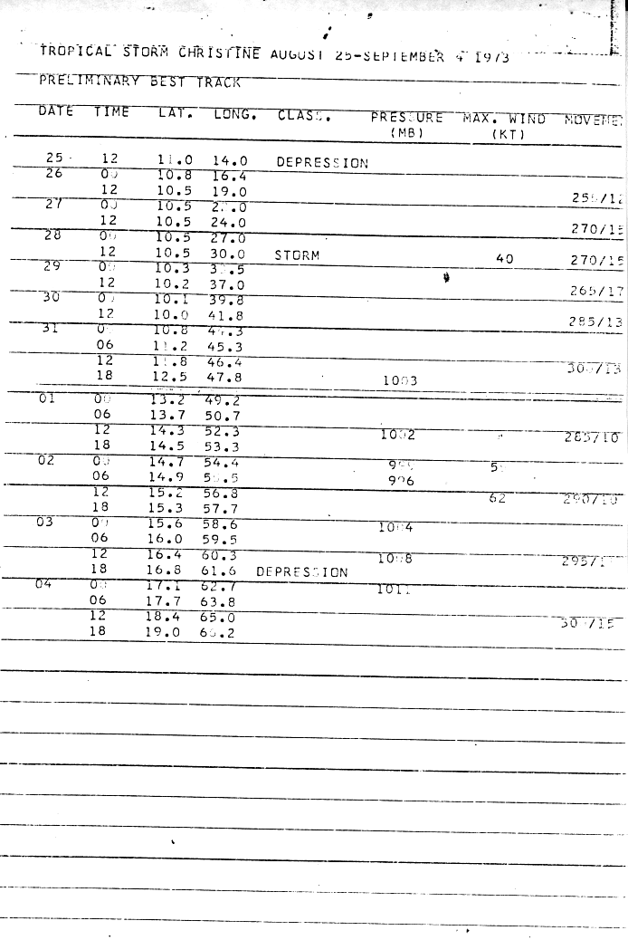
And there's this gem: http://www.nhc.noaa.gov/archive/storm_w ... elim03.gif
But Jeanne 98 was a September storm, and the storm whose report I linked to was an August storm... you just don't see systems hitting the ground (water) running this time of year...the July storms to do it (Anna 1969, Ceasar 1990, Alex 1998) all formed in the last week of the month.
0 likes

clfenwi wrote:And there's this gem: http://www.nhc.noaa.gov/archive/storm_w ... elim03.gif
That is so cool. She became a depression and didn't even hit the water yet! She formed on Africa! Tropical Storm Christine sure is odd. However, she also died right in the prime area where the waters should be hot and ready to make her explode. I don't know why but I can look it up.
Tropical Storm #6 of 1988 also formed very close to Africa.
0 likes
-
HurricaneHunter914
- Category 5
- Posts: 4439
- Age: 32
- Joined: Fri Mar 10, 2006 7:36 pm
- Location: College Station, TX
http://www.ssd.noaa.gov/PS/TROP/DATA/RT/EATL/IR4/20.jpg
That wave over Africa looks like it has some cyclonic turning aswell.
That wave over Africa looks like it has some cyclonic turning aswell.
0 likes
Personal Forecast Disclaimer:
The posts in this forum are NOT official forecast and should not be used as such. They are just the opinion of the poster and may or may not be backed by sound meteorological data. They are NOT endorsed by any professional institution or storm2k.org. For official information, please refer to the NHC and NWS products.
The posts in this forum are NOT official forecast and should not be used as such. They are just the opinion of the poster and may or may not be backed by sound meteorological data. They are NOT endorsed by any professional institution or storm2k.org. For official information, please refer to the NHC and NWS products.
-
whereverwx
- Category 5
- Posts: 1109
- Joined: Mon May 31, 2004 10:15 pm
Tampa_God wrote:awesome loop calamity. Look at all those waves that came off and nothing forms. Lets see if that changes.
Thanks!
HurricaneHunter914 wrote:http://www.ssd.noaa.gov/PS/TROP/DATA/RT/EATL/IR4/20.jpg
That wave over Africa looks like it has some cyclonic turning aswell.
Funny thing; I counted about 20 other waves that looked like that in the loop I posted.
0 likes
-
HurricaneJoe22
- Category 1

- Posts: 456
- Joined: Wed Sep 08, 2004 12:45 am
- Location: Temple, Texas
-
cycloneye

- Admin

- Posts: 148767
- Age: 69
- Joined: Thu Oct 10, 2002 10:54 am
- Location: San Juan, Puerto Rico
00:00z Full Fisk Image

I keep watching not the area just off Africa,but the area almost in the central part of the continent.
I keep watching not the area just off Africa,but the area almost in the central part of the continent.
0 likes
-
HurricaneHunter914
- Category 5
- Posts: 4439
- Age: 32
- Joined: Fri Mar 10, 2006 7:36 pm
- Location: College Station, TX
That area just off Africa is holding nicely probably not much in the way of development but nice to watch.
0 likes
Personal Forecast Disclaimer:
The posts in this forum are NOT official forecast and should not be used as such. They are just the opinion of the poster and may or may not be backed by sound meteorological data. They are NOT endorsed by any professional institution or storm2k.org. For official information, please refer to the NHC and NWS products.
The posts in this forum are NOT official forecast and should not be used as such. They are just the opinion of the poster and may or may not be backed by sound meteorological data. They are NOT endorsed by any professional institution or storm2k.org. For official information, please refer to the NHC and NWS products.
-
cheezyWXguy
- Category 5
- Posts: 6242
- Joined: Mon Feb 13, 2006 12:29 am
- Location: Dallas, TX
-
gatorcane

- S2K Supporter

- Posts: 23703
- Age: 47
- Joined: Sun Mar 13, 2005 3:54 pm
- Location: Boca Raton, FL
yeah same with me. Here is another shot of it though:
It's quite an intense area of thunderstorms as Luis has pointed out:
http://cimss.ssec.wisc.edu/tropic/real- ... rmet7n.GIF
It's quite an intense area of thunderstorms as Luis has pointed out:
http://cimss.ssec.wisc.edu/tropic/real- ... rmet7n.GIF
0 likes
-
cycloneye
- Admin
- Posts: 148767
- Age: 69
- Joined: Thu Oct 10, 2002 10:54 am
- Location: San Juan, Puerto Rico
cheezywxman wrote:the full disk image wont work for me...it keeps asking me for a password
Oh,I forgot to say that first you have to register to get the images but is free of cost.
0 likes
Visit the Caribbean-Central America Weather Thread where you can find at first post web cams,radars
and observations from Caribbean basin members Click Here
and observations from Caribbean basin members Click Here
-
cycloneye
- Admin
- Posts: 148767
- Age: 69
- Joined: Thu Oct 10, 2002 10:54 am
- Location: San Juan, Puerto Rico
NRL Image
If you recall the first post of this thread I said about an area I was watching in the Central Part of the Continent of Africa because of some pressure falls in Niger.Now here it is about to emerge Western Africa.But it will fizzle for sure as it's not the prime time yet for systems to develop that far east.But anyway it's interesting to follow these waves thru the African Continent from the Eastern part to the Western part.
If you recall the first post of this thread I said about an area I was watching in the Central Part of the Continent of Africa because of some pressure falls in Niger.Now here it is about to emerge Western Africa.But it will fizzle for sure as it's not the prime time yet for systems to develop that far east.But anyway it's interesting to follow these waves thru the African Continent from the Eastern part to the Western part.
0 likes
Who is online
Users browsing this forum: No registered users and 37 guests