Germany-City in south. germany beat up
Moderator: S2k Moderators
Forum rules

The posts in this forum are NOT official forecast and should not be used as such. They are just the opinion of the poster and may or may not be backed by sound meteorological data. They are NOT endorsed by any professional institution or STORM2K.


-
P.K.

- Professional-Met

- Posts: 5149
- Joined: Thu Sep 23, 2004 5:57 pm
- Location: Watford, England
- Contact:
The European will have more information on this.
0 likes


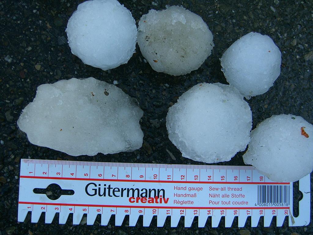
That was really intense. A guy from the german forum ist going to visit a person, having freezed in hailstones of 5". Let´s look, if that´s true...
Last edited by Bunkertor on Thu Jun 29, 2006 3:44 pm, edited 1 time in total.
0 likes
-
P.K.
- Professional-Met
- Posts: 5149
- Joined: Thu Sep 23, 2004 5:57 pm
- Location: Watford, England
- Contact:
Freak weather kills German farmer
A freak hailstorm and heavy rain in south-west Germany has left one man dead and about one hundred injured.
Police said a farmer drowned as he tried to move his herd following flash floods near Offenburg, in the Black Forest region of Baden-Wuerttemberg.
Some 100 people were hurt, mostly with cuts to the head, when hailstones said to be the size of tennis balls fell in Villingen-Schwenningen.
Severe weather also damaged many cars and wrecked a bridge in the region.
Emergency services said many people had to be taken to hospital for treatment, the AFP news agency reported.
"It looks like a war has hit us," a fireman was quoted as saying.
Many homes were left without electricity.
Residents told Reuters news agency it was one of the worst storms they had experienced.
http://news.bbc.co.uk/1/hi/world/europe/5128324.stm
0 likes


-
remy

- Tropical Low

- Posts: 19
- Joined: Fri Jun 30, 2006 12:29 pm
- Location: Toulouse-Blagnac France
- Contact:
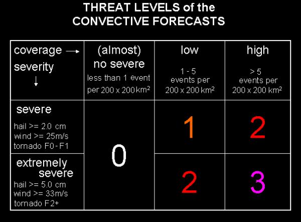
Beautiful picture. So that is the bulletin of European Storm Forecast Experiment of the 28 june 2006 :

Storm Forecast
Valid: Wed 28 Jun 2006 06:00 to Thu 29 Jun 2006 06:00 UTC
Issued: Tue 27 Jun 2006 23:15
Forecaster: GROENEMEIJER
SYNOPSIS
Wednesday at 06:00 UTC a southwesterly flow is located over much of Wrn and Ctrl Europe. A vort max induced by convection over Ern France on Tuesday is expected to traverse along the periphery of a broad ridge across southern Germany, Austria/Czech eastward. A shortwave trough over Wrn France is expected to move slowly eastward.
DISCUSSION
SErn Germany, Czech, Slovak, Austria, Hungary, Srn Poland, Wrn Ukraine, Nrn and Wrn Balkans
The aforementioned vort max and outflow boundaries of Tuesday's convection will likely induce sufficient upward vertical motion for the development or reintensification of convective storms during the early afternoon over SErn Germany, the Wrn Czech Rep. and/or Austria.
Given that about 20 m/s 0-6 km bulk shear is expected, storms will likely again include splitting storms / supercells. These will have a primary threat of producing large hail, possibly very large in places.
Convection will cluster into a large bowing system that works its way eastward during the afternoon and evening hours. The system should be capable of producing rather widespread damaging winds in addition to large hail. A major threat should be very high precipitation as well with local flash flooding as a result. Note that the flash flood threat is not incorporated in the threat level.
Various numerical models including GFS, INM-Hirlam, AFWA-MM5 agree on the development of a very intense system out of this. GFS at 18Z even had a vortex with 20 m/s cyclonic winds, indicative of MCC development. If such winds develop, low-level shear could become favourable for the development of tornadoes in some places.
Numerical models do not indicate that the system will bend too far SEward into Srn Hungary and the northwestern Balkans. However, this appears to be possible, certainly as the extreme low-level moisture and hence MLCAPE, that should approach 3000 J/kg once again appears not to be fully grasped by the models.... and MCS's have a tendency to propagate towards areas of high CAPE.
More isolated convection is locally possible as well across the northern and western Balkans that could bring large hail and a few strong gusts.
France, Switzerland, SWrn Germany, northern Italy
On the approach of the trough intially over western France, rising motions are expected over eastern France leading to the redevelopment of instability on the order of about 1000 J/kg MLCAPE. Moderate ~15-20 m/s deep-layer shear over NErn France and SWrn Germany and slightly higher over SErn France and Italy should prove sufficient for the development of well-organized multicells and supercells. These should have a main threat of producing large hail, although some strong and locally severe gusts are not ruled out either. Renewed development of small bowing convection with an attendant severe wind threat cannot be ruled out either.
0 likes

-
TheEuropean

- Professional-Met
- Posts: 1797
- Age: 60
- Joined: Tue Sep 20, 2005 3:17 pm
- Location: Voerde, Germany
- Contact:
CrazyC83 wrote:That Level 2 would be equivalent to an SPC Moderate Risk.
Were there any tornadoes?
Yes, there is one case we investigate in the late evening of June 28th. But in the days before we had several tornados in Germany:
http://www.tornadoliste.de
Sorry, I'm in holidays, so I missed this thréad. There are many links on my (german) hail site
http://www.naturgewalten.de/hagel.htm
TheEuropean
0 likes

Hello from Austria.
Its nice to see that may pictures are traveling all over the wordl *g*
http://www.skywarn.at/forum/showtopic.p ... adid=11782
i do storm chasing for about 7 years and we have great storms here in austria - graz. every year about 4 supercells and 40 storum over the city. 1-2 tornados also.
maybe i will post more chasing reports from austria here
0 likes
-
george_r_1961

- S2K Supporter

- Posts: 3171
- Age: 64
- Joined: Sat Oct 12, 2002 9:14 pm
- Location: Carbondale, Pennsylvania
Who is online
Users browsing this forum: No registered users and 8 guests