I don't even want to get into an argument with ken. I have before and learned that it was just a waste of time. He's been known to stir fights on message boards.
Anyways....just to add to the conversation, our annemometer at work, IN COVINGTON, broke during a 121mph gust...that was in COVINGTON, La! We were about 20 miles West of the eye as it crossed the La/Ms state line. No doubt in my mind the winds were much higher than 100mph at landfall...the damage proves it. Most of the pictures that were on the news and on the net do no justice to the true damage.
I get this sinking feeling its going to ramp up...
Moderator: S2k Moderators
Forum rules

The posts in this forum are NOT official forecasts and should not be used as such. They are just the opinion of the poster and may or may not be backed by sound meteorological data. They are NOT endorsed by any professional institution or STORM2K. For official information, please refer to products from the National Hurricane Center and National Weather Service.

We all have a tendency to believe storms we have experienced in person are the worst. It's pointless to argue which storm was the worst, anyway. The absolute facts can be found in the reports from the NHC and local NWS offices. Those are objective, listing facts about wind speed, barometric pressure, storm surge, etc. Trying to judge hurricane strength by photos of damage is highly subjective. At any rate, it's unlikely any argument is going to change anyone's mind. Besides, all the argument really has little to do with the topic of this thread, which is about the season "ramping up." I'd really like to hear some opinions from y'all about when you think things might start getting busy. Y'all certainly know more than I do! So, let's hear 'em! 
0 likes
-
Audrey2Katrina

- Category 5

- Posts: 4252
- Age: 76
- Joined: Fri Dec 23, 2005 10:39 pm
- Location: Metaire, La.
We all have a tendency to believe storms we have experienced in person are the worst.
Almost invariably true... we tend to look at the world from a "my world" perspective. Some can be more objective than others; but as a whole, this is all but an unwritten "law" of human nature. You are also 100% correct that these kinds of debates/arguments can and will go back and forth forever with nothing resolved. to each his/her own!
The absolute facts can be found in the reports from the NHC
While I have said before, I have every respect for the NHC and the devoted workers there, nothing in science can be termed "absolute" Even many facets of Einstein's theory of Relativity have come into question... Steve Hawking has all but proven the "absolute" belief that nothing escapes a black hole. What the NHC has is the "official" facts, as presented, and even they admit room for possible error, and that many of these facts are estimations--hence not facts, beyond the fact that they are educated, and doubtless well thought out estimations. (hence again.. the perpetual debates!
On your point about getting back to topic... I couldn't agree more. I tried to say as much in my last post.
I think the season isn't going to "Ramp up" for at least another 3 weeks or more. The conditions just don't seem to be there, and forecasts beyond that length of time are more often "guess" casts than anything else. Personally, I hope thinks don't "ramp up" for quite some time, and as already stated... they remain FISH!
We need a break!... of course mother nature might have other plans.
A2K
0 likes
-
Extremeweatherguy

- Category 5
- Posts: 11095
- Joined: Mon Oct 10, 2005 8:13 pm
- Location: Florida
Wow. I have not checked in on this thread in awhile and have been missing a good debate! 
Here is my input:
Ken - I agree on the fact that Katrina was a Category 3 at landfall, but I do not agree with your report of 78mph winds and gusts to 94mph being her top recorded speeds. I have seen clear evidence of winds over 100mph sustained in many places. Also, Katrina (like Hugo) brought high winds well inland. In fact, I have heard that Hurricane force gusts were felt nearly 200 miles north of her landfall. High winds inland are not that uncommon either...other examples include Fran in Raleigh, Hazel up the east coast (hurricane force winds in DC and 90mph gusts in upstate NY), Charley in Orlando, Rita in Jasper, Jeanne in central FL, Frances in central FL, Wilma in Miami, etc. Nearly every major hurricane brings hurricane force winds over 50 miles inland!
Stratusxpeye - I agree with you that Charley was an amazing storm. Wind gusts well over 170mph downed metal, concrete, and wood light poles...crushed water towers, obliterated homes and even leveled entire forests. Also, as you said, it could have been even worse if it had stayed over water a bit longer. It was just 6mph away from being the United States' 4th landfalling Cat. 5. There is no denying Charley was one of the most powerful 'wind producing' hurricanes. His surge, however, was in no comparison with Katrina's (due to her larger size).
Also, here is a nice comparison between surge and wind damage from the three most discussed storms on this thread (Hugo, Katrina, and Charley) for those that need a better mental picture:
KATRINA
http://www.ucar.edu/news/releases/2005/ ... biloxi.jpg
^^Amazing surge damage, but trees remain standing in this area of Biloxi^^
http://www.maritimemuseum.org/katrina/Dsc00056.jpg
^^More surge damage from Katrina. Also, note that the tree limbs are defoliated and many branches are missing. There are also a few missing shingles and sign pieces. This leads me to believe Cat. 2 force winds were in this area (Biloxi)^^
http://www.railwaypreservation.com/vint ... mage_1.jpg
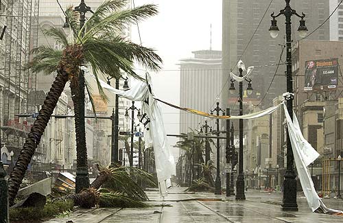
^^Downtown N.O. looks to have recieved Cat. 1 force winds. This is visible in the fact that many palms are bent (or downed), and a large tarp from a sign has been blown across the power lines. The billboard on the right was not damaged and the construction supplies to the left also seem to be ok. All the light poles are also standing. This is why I believe winds were only Cat. 1 force in this area.^^
http://ccma.nos.noaa.gov/images/katrina/damage.jpg
^^Amazing surge damage. I was on this bridge just a few weeks before Katrina.^^
http://www.neworleanscitypark.com/katri ... g_6154.jpg
^^Katrina pine tree damage^^
**Wind damage was even worse near Buras. Likely in the Cat. 3 range.**
HUGO
http://www.photolib.noaa.gov/historic/n ... a00479.jpg
^^Hugo damage well inland at Charlotte. 100mph gusts.^^
http://pubs.usgs.gov/circ/c1075/images/sullivans.gif
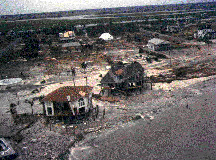
^^SC coastal Hugo damage (Sullivans Island). Looks like a moderate surge and only Cat. 2 force winds in this area. The reason this looks like Cat. 2 winds is because of the collapsed wall of one of the beach homes (which may have even been surge related). Otherwise, most of the damage looks to be in the Cat. 1 range.^^
http://people.cas.sc.edu/carbone/module ... se3%20(450).jpeg
^^Another picture from Sullivans Island. This also looks like Cat. 2 force winds with a moderate surge. Most of this Home damage is surge related, but the broken windows lead me to believe that high winds were also a factor.^^
http://www.photolib.noaa.gov/historic/n ... a00473.jpg
^^Most Surfside beach mobile homes and trees seem to have fared well with Hugo. The only major damage is from the surge in this photo. I would guess that this area saw Cat. 1 force winds (at most).^^
http://www.photolib.noaa.gov/historic/nws/wea00477.htm
^^Oak tree damage in Charleston from Hugo. Looks like Cat. 1/2 force damage.^^
http://www.photolib.noaa.gov/historic/n ... a00472.jpg
^^Hugo SC surge damage^^
**There was probably a few instances of worse coastal wind damage, but I could not find any pictures of this.**
CHARLEY
http://news.bbc.co.uk/media/images/3996 ... pgetty.jpg
^^widespread mobile home and tree damage looks to be caused by Cat. 2/3 force winds in this area.^^
http://www.swissre.com/INTERNET/pwsgrap ... 50_200.jpg
^^Charley surge damage.^^
http://www.2004hurricanes.com/charley/carnage.jpg
^^This charley damage looks to be the result of AT LEAST Cat. 3 force winds.^^
http://www.2004hurricanes.com/charley/19.jpg
^^Cat. 3/4 force damage in Punta Gorda. This is based on the major damage to the well built structure in the background and to the left. ^^
http://www.2004hurricanes.com/charley/24.jpg
^^This mobile home damage looks to be the result of Cat. 2/3 force winds.^^
http://www.2004hurricanes.com/charley/7.jpg
^^This hotel was destroyed by wind alone, and looks to be the work of a Cat. 3/4 force wind.^^
http://soundwaves.usgs.gov/2005/03/watertowerLG.jpg
^^Hurricane Charley damage about 30 miles inland. Looks like Cat. 2/3 force winds (note the trees broken off at their bases).^^
Here is my input:
Ken - I agree on the fact that Katrina was a Category 3 at landfall, but I do not agree with your report of 78mph winds and gusts to 94mph being her top recorded speeds. I have seen clear evidence of winds over 100mph sustained in many places. Also, Katrina (like Hugo) brought high winds well inland. In fact, I have heard that Hurricane force gusts were felt nearly 200 miles north of her landfall. High winds inland are not that uncommon either...other examples include Fran in Raleigh, Hazel up the east coast (hurricane force winds in DC and 90mph gusts in upstate NY), Charley in Orlando, Rita in Jasper, Jeanne in central FL, Frances in central FL, Wilma in Miami, etc. Nearly every major hurricane brings hurricane force winds over 50 miles inland!
Stratusxpeye - I agree with you that Charley was an amazing storm. Wind gusts well over 170mph downed metal, concrete, and wood light poles...crushed water towers, obliterated homes and even leveled entire forests. Also, as you said, it could have been even worse if it had stayed over water a bit longer. It was just 6mph away from being the United States' 4th landfalling Cat. 5. There is no denying Charley was one of the most powerful 'wind producing' hurricanes. His surge, however, was in no comparison with Katrina's (due to her larger size).
Also, here is a nice comparison between surge and wind damage from the three most discussed storms on this thread (Hugo, Katrina, and Charley) for those that need a better mental picture:
KATRINA
http://www.ucar.edu/news/releases/2005/ ... biloxi.jpg
^^Amazing surge damage, but trees remain standing in this area of Biloxi^^
http://www.maritimemuseum.org/katrina/Dsc00056.jpg
^^More surge damage from Katrina. Also, note that the tree limbs are defoliated and many branches are missing. There are also a few missing shingles and sign pieces. This leads me to believe Cat. 2 force winds were in this area (Biloxi)^^
http://www.railwaypreservation.com/vint ... mage_1.jpg
^^Downtown N.O. looks to have recieved Cat. 1 force winds. This is visible in the fact that many palms are bent (or downed), and a large tarp from a sign has been blown across the power lines. The billboard on the right was not damaged and the construction supplies to the left also seem to be ok. All the light poles are also standing. This is why I believe winds were only Cat. 1 force in this area.^^
http://ccma.nos.noaa.gov/images/katrina/damage.jpg
^^Amazing surge damage. I was on this bridge just a few weeks before Katrina.^^
http://www.neworleanscitypark.com/katri ... g_6154.jpg
^^Katrina pine tree damage^^
**Wind damage was even worse near Buras. Likely in the Cat. 3 range.**
HUGO
http://www.photolib.noaa.gov/historic/n ... a00479.jpg
^^Hugo damage well inland at Charlotte. 100mph gusts.^^
http://pubs.usgs.gov/circ/c1075/images/sullivans.gif
^^SC coastal Hugo damage (Sullivans Island). Looks like a moderate surge and only Cat. 2 force winds in this area. The reason this looks like Cat. 2 winds is because of the collapsed wall of one of the beach homes (which may have even been surge related). Otherwise, most of the damage looks to be in the Cat. 1 range.^^
http://people.cas.sc.edu/carbone/module ... se3%20(450).jpeg
^^Another picture from Sullivans Island. This also looks like Cat. 2 force winds with a moderate surge. Most of this Home damage is surge related, but the broken windows lead me to believe that high winds were also a factor.^^
http://www.photolib.noaa.gov/historic/n ... a00473.jpg
^^Most Surfside beach mobile homes and trees seem to have fared well with Hugo. The only major damage is from the surge in this photo. I would guess that this area saw Cat. 1 force winds (at most).^^
http://www.photolib.noaa.gov/historic/nws/wea00477.htm
^^Oak tree damage in Charleston from Hugo. Looks like Cat. 1/2 force damage.^^
http://www.photolib.noaa.gov/historic/n ... a00472.jpg
^^Hugo SC surge damage^^
**There was probably a few instances of worse coastal wind damage, but I could not find any pictures of this.**
CHARLEY
http://news.bbc.co.uk/media/images/3996 ... pgetty.jpg
^^widespread mobile home and tree damage looks to be caused by Cat. 2/3 force winds in this area.^^
http://www.swissre.com/INTERNET/pwsgrap ... 50_200.jpg
^^Charley surge damage.^^
http://www.2004hurricanes.com/charley/carnage.jpg
^^This charley damage looks to be the result of AT LEAST Cat. 3 force winds.^^
http://www.2004hurricanes.com/charley/19.jpg
^^Cat. 3/4 force damage in Punta Gorda. This is based on the major damage to the well built structure in the background and to the left. ^^
http://www.2004hurricanes.com/charley/24.jpg
^^This mobile home damage looks to be the result of Cat. 2/3 force winds.^^
http://www.2004hurricanes.com/charley/7.jpg
^^This hotel was destroyed by wind alone, and looks to be the work of a Cat. 3/4 force wind.^^
http://soundwaves.usgs.gov/2005/03/watertowerLG.jpg
^^Hurricane Charley damage about 30 miles inland. Looks like Cat. 2/3 force winds (note the trees broken off at their bases).^^
Last edited by Extremeweatherguy on Tue Jun 20, 2006 6:41 pm, edited 1 time in total.
0 likes

Wow Extremeweatherguy... you put a lot of work into that post. Good job!
As far as the topic at hand, remember, even last year had an extended lull. I distinctly remember a thread about it. I posted in that thread... I'll find it and edit it into this post.
EDIT: And here's the thread... http://www.storm2k.org/phpbb2/viewtopic ... highlight=
As far as the topic at hand, remember, even last year had an extended lull. I distinctly remember a thread about it. I posted in that thread... I'll find it and edit it into this post.
EDIT: And here's the thread... http://www.storm2k.org/phpbb2/viewtopic ... highlight=
0 likes
-
beachbum_al

- Category 5
- Posts: 2163
- Age: 55
- Joined: Thu Jul 14, 2005 9:23 pm
- Location: South Alabama Coast
- Contact:

[quote="Extremeweatherguy"]^^SC coastal Hugo damage (Sullivans Island). Looks like a moderate surge and only Cat. 2 force winds in this area. The reason this looks like Cat. 2 winds is because of the collapsed wall of one of the beach homes (which may have even been surge related). Otherwise, most of the damage looks to be in the Cat. 1 range.^^
http://people.cas.sc.edu/carbone/module ... se3%20(450).jpeg
^^Another picture from Sullivans Island. This also looks like Cat. 2 force winds with a moderate surge. Most of this Home damage is surge related, but the broken windows lead me to believe that high winds were also a factor.^^
http://www.photolib.noaa.gov/historic/n ... a00473.jpg
^^Most Surfside beach mobile homes and trees seem to have fared well with Hugo. The only major damage is from the surge in this photo. I would guess that this area saw Cat. 1 force winds (at most).^^
--I disagree with this one. We had an entire restaurant destroyed at Folly Beach and also nearly all pine trees snapped in more than half, plus Sullivan's Island sustaned severe damage from the pictures I saw. We took pictures in 1989 and there was a house in the middle of the street (actually several) after a 10 ft wall of water smashed onto Sullivan's Island. The Ben Sawyer draw bridge was toppled into the water. Today we don't see those types of hurricanes as often anymore,IMO. According to the NHC, sustained winds from Katrina was 78 mph, gust to 94 - a cat 1 as far as winds go. Hugo was much stronger than that (as far as winds go). The last cat 4 was Charley to hit the US.--
In addition, this season will not live up to its expectations anyway. Lower water temperatures in the Atlantic, more shear, and the lowest Atlantic Multidecadal oscillation index since 1994 !
Here was one great analysis by a guy named Chuck about this season's expectations:
- ENSO conditions (Nino or Nina)
- TNI index (Trans-Nino index)
- Atlantic multidecadal Oscillation (AMO)
ENSO (Region 3.4)
Several studies have shown that a La Nina favors less shear in the Atlantic which would in turn allow for more storms to organize than what is considered average. The average number of named storms per year is 9.0 --- During La Nina tropical seasons, the Atlantic averages 11.0 named storms per year.
Several studies have shown that an El Nino favors above average shear in the Atlantic which would in turn somewhat prevent storms from forming. The average number of named storms per year is 9.0 --- During El Nino tropical seasons, the Atlantic averages 8.7 named storms per year, BUT if you take out 04 since the Nino became official very late in the season, the Atlantic averages 7.7 named storms per year during Nino's.
A few days ago, I made a prediction in THIS THREAD that our La Nina is dying, and will not last through the summer. Based on current data, I would put the following chances on this tropical seasons ENSO conditions ---
60% Chance it is ENSO NEUTRAL
25% Chance we see an EL NINO
15% Chance we see a LA NINA
If neutral like expected, the Nino 3.4 region will not have a big impact on this upcoming hurricane season. But do keep in mind that I do think we have a better chance of seeing a Nino than a Nina.
In conclusion, this years ENSO state will not be the determining factor in how active the Atlantic is.
TNI index
My studies have shown that a negative TNI, just like a Nina, favors above average tropical activity in the Atlantic.
Tropical seasons that had a very positive TNI (above +0.8), averaged 8.5 named storms a year. Tropical seasons that had a very negative TNI (below -0.8), averaged 11.7 named storms a year. According to these stats, the correlation is stronger with the TNI than it is with Nino 3.4. So again...
- Positive TNI = Less tropical activity
- Negative TNI = More tropical activity.
Lets now look at where the TNI is heading for Tropical season 2006...
The TNI is a long term index. It runs in intervals of 1-5 years. Over the past 5 years, the TNI has been running severely negative. This has been part of the reason why the Atlantic has averaged 18.4 named a storms a year. Here is the data from 2001 to 2005 --
The last reading recorded was the highest it has been since April of 2001. In other words, the TNI is now rising... Rapidly. Here is another graph showing the TNI's ups and downs over the years (this is not a recent map) --
As you can see by that graph, the TNI is overdo for a rise.
With that being said, I expect the TNI to read neutral or positive this hurricane season limiting the amount of tropical activity. The neutral-positive TNI state will favor AVERAGE TO BELOW AVERAGE tropical activity this season.
Atlantic multidecadal Oscillation
This is, in my opinion, the most important of the three.
The Atlantic multidecadal Osciallation is just what its name implies --- A decal oscillation which computes Atlantic SST anomalies north of the equator. When this index is positive, the waters are warmer in the Atlantic which supports above average tropical activity. When this index is negative, waters are cooler in the Atlantic which in turn supports below average tropical activity.
From 1931-1966, this index ran positive 90% of the time. This helped this time period produce a lot of tropical activity. Before this past year, 1933 held the record with the most named storms in a year.
From 1967-1988, this index ran negative 90% of the time. This helped this time period generally produce below average tropical activity. Despite the fact that La Nina's occurred very often in the 60's and 70s, when averaged out, the 67-88 time period is below average in tropical activity.
From 1989-1994, the AMO switched to a positive stage. Although positive, the anomalies were very close to neutral.
From 1995-present, the AMO has been 100% positive. The last time it was negative was September of 1994. In recent years, the AMO has risen higher than it ever has. The 5 most positive AMO tropical periods ever recorded are the following:
-03
-05
-98
-04
-01
These are all in recent years. This is another big part of the reason why tropical activity has been so above average as of late. In the top 5 AMO years, the Atlantic AVERAGES 18.4 named storms a year.
Here is an AMO chart from the past 10 years...
As you can see in the image above, over the past few months, the AMO has taken a SIGNIFICANT step down. The March 2006 AMO reading is the lowest recorded in almost 12 years. With the AMO now much weaker than what it has been in previous years, I dont expect near as much activity to occur this year as what had happened in recent years. However, Since we are still running in a positive phase, I would say that the AMO stays positive for the tropical season, just not as positive as what we have seen (closer to neutral).
In conclusion, the AMO this tropical season will favor SLIGHTLY ABOVE AVERAGE TROPICAL ACTIVITY
The reason for the severe recent spike in tropical activity over the past 5 years is to be attributed to the combination of a severe TNI spike, and a record high AMO. With both of these factors becoming much less impressive as of late, I dont expect this year to live up to its hype.
So far, I have heard forecasters mention anything from 16-22 named storms this year with several major landfalling hurricanes.
With a Neutral Nino 3.4 region (maybe even Nino), neutral or positive TNI, and positive but weak AMO, I expect a near normal tropical year. Based on all this, here is my prediction for hurricane season 2006 ----
- 13 named storms (Its only that many because the Gulf is warm)
- 6 Hurricanes
- 2 Major Hurricanes
- Cooler waters in the Atlantic will mean that we wont see an active "pre-season" like what we have seen the past few years.
Last edited by kenl01 on Wed Jun 21, 2006 9:49 am, edited 1 time in total.
0 likes
-
skysummit

- S2K Supporter

- Posts: 5305
- Age: 50
- Joined: Tue Aug 31, 2004 11:09 pm
- Location: Ponchatoula, LA
- Contact:
Ok Ken...you really need to get your facts straight and stop posting these inaccurate posts. No where does the NHC say that Katrina was 78mph at landfall. No where do they say she was a Cat 1 at landfall. Katrina BLOWS away Hugo in every category imaginable.
We no longer have storms like Hugo???? You're kidding me bud.....Katrina...the biggest storm surge in U.S. history. What about Ivan that took out the I-10 Pensacola Bay Bridge??? What about Katrina which took out the I-10 Twinspan, the Bay St. Louis Bay Bridge, and the Ocean Springs Bridge on Hwy 90??? Remember Wilma??? The LOWEST pressure EVER observed in the Atlantic Basin. Seriously Ken...you need to stop.
I'm all about not posting what people "think" the strength of Katrina was, but your information is beyond ridiculous.
0 likes
skysummit wrote:Ok Ken...you really need to get your facts straight and stop posting these inaccurate posts. No where does the NHC say that Katrina was 78mph at landfall. No where do they say she was a Cat 1 at landfall. Katrina BLOWS away Hugo in every category imaginable.
We no longer have storms like Hugo???? You're kidding me bud.....Katrina...the biggest storm surge in U.S. history. What about Ivan that took out the I-10 Pensacola Bay Bridge??? What about Katrina which took out the I-10 Twinspan, the Bay St. Louis Bay Bridge, and the Ocean Springs Bridge on Hwy 90??? Remember Wilma??? The LOWEST pressure EVER observed in the Atlantic Basin. Seriously Ken...you need to stop.
I'm all about not posting what people "think" the strength of Katrina was, but your information is beyond ridiculous.
You have no facts straight at all. Say whatever you want - it won't do you any good. Get an education guy and check the statistics from the NHC in the last 50 years, showing a DECREASE in hurricane INTENSITY in the Atlantic and lower LANDFALLS in the US. We don't get anything anymore like we used to, say, 100 years ago.
These hurricanes today are all whimps campared to the past times
0 likes

-
skysummit
- S2K Supporter
- Posts: 5305
- Age: 50
- Joined: Tue Aug 31, 2004 11:09 pm
- Location: Ponchatoula, LA
- Contact:
kenl01 wrote:
You have no facts straight at all. Say whatever you want - it won't do you any good. Get an education guy and check the statistics from the NHC in the last 50 years, showing a DECREASE in hurricane INTENSITY in the Atlantic and lower LANDFALLS in the US. We don't get anything anymore like we used to, say, 100 years ago.
These hurricanes today are all whimps campared to the past times
Yes, I agree that there has been a decrease in overall hurricane intensity over the past 50 years with the exception of the last few. We are on the increase again...stronger, bigger, and more frequent storms. Remember last year? How many named storms did we have??? How many Cat 5's did we have??? How many records were broken???
It's obvious you have no respect for the tropics when you call these hurricanes "wimps". You say you've been through Hugo, but by the posts you make, I HIGHLY doubt it. If you've ever been through a TRUE storm, you would think more before you hit that "submit" button.
0 likes
-
skysummit
- S2K Supporter
- Posts: 5305
- Age: 50
- Joined: Tue Aug 31, 2004 11:09 pm
- Location: Ponchatoula, LA
- Contact:
Oh...another thing Ken. Here's the official NHC Tropical Cyclone Report for Hurricane Katrina where it clearly states that she made her first landfall near Buras, La. as an upper end Category 3 hurricane, and her second landfall near the mouth of the Pearl River STILL as a Category 3 hurricane.
Please, oh please back up your statement that the NHC says she was a 78mph weak Cat 1 hurricane.
Please, oh please back up your statement that the NHC says she was a 78mph weak Cat 1 hurricane.
0 likes
-
skysummit
- S2K Supporter
- Posts: 5305
- Age: 50
- Joined: Tue Aug 31, 2004 11:09 pm
- Location: Ponchatoula, LA
- Contact:
kenl01 wrote:According to the NHC, sustained winds from Katrina was 78 mph, gust to 94 - a cat 1 as far as winds go.
Oh...another thing Ken. Here's the official NHC Tropical Cyclone Report for Hurricane Katrina where it clearly states that she made her first landfall near Buras, La. as an upper end Category 3 hurricane, and her second landfall near the mouth of the Pearl River STILL as a Category 3 hurricane.
Please, oh please back up your statement that the NHC says she was a 78mph weak Cat 1 hurricane.
http://www.nhc.noaa.gov/pdf/TCR-AL122005_Katrina.pdf
Last edited by skysummit on Wed Jun 21, 2006 10:19 am, edited 1 time in total.
0 likes
-
jasons2k

- Storm2k Executive

- Posts: 8253
- Age: 52
- Joined: Wed Jul 06, 2005 12:32 pm
- Location: The Woodlands, TX
Ken,
Katrina is thus far the worst hurricane to ever hit the US in terms of storm surge and economic losses.
Hugo didn't "change everything"; Katrina did.
Hugo didn't spark wall-to-wall coverage on the networks for several weeks; Katrina did.
Hugo didn't send hundreds of thousands of refugees all across the SE and the nation; Katrina did.
Look at the pictures from Hugo and compare them to the pictures from Katrina.
There is no comparison.
A picture says a thousand words.
0 likes
-
Stormcenter
- S2K Supporter
- Posts: 6687
- Joined: Wed Sep 03, 2003 11:27 am
- Location: Houston, TX
jschlitz wrote:Ken,
Katrina is thus far the worst hurricane to ever hit the US in terms of storm surge and economic losses.
Hugo didn't "change everything"; Katrina did.
Hugo didn't spark wall-to-wall coverage on the networks for several weeks; Katrina did.
Hugo didn't send hundreds of thousands of refugees all across the SE and the nation; Katrina did.
Look at the pictures from Hugo and compare them to the pictures from Katrina.
There is no comparison.
A picture says a thousand words.
Ha ! Yeaugh right ! If you are referring to storm surge, I would agree with Katrina. Not with the actual intensity , however. It's ridiculous to keep mentioning that stuff about Katrina because we had much stronger hurricanes in the past, like Camille, at landfall, and Hugo, at landfall. Hugo was much stronger as far as winds are concerned. And winds mean everything. If there's just storm surge damage, but lack of wind, it wouldn't qualify as the same thing. You have to have the sustained winds. Sorry to bust your bubble with this, but here's just a reminder of hurricane trends over the last 50 years, according to the NHC:
http://www.nhc.noaa.gov/pastdec.shtml#history

Additionally, the National Hurricane Center Web site says that the peak for major hurricanes was between 1930 and 1950, when storms averaged nine per year; today, the average is three. Nor is hurricane strength intensifying; since the 1940s, the mean maximum intensity has actually decreased.
0 likes
-
skysummit
- S2K Supporter
- Posts: 5305
- Age: 50
- Joined: Tue Aug 31, 2004 11:09 pm
- Location: Ponchatoula, LA
- Contact:
skysummit wrote:kenl01 wrote:According to the NHC, sustained winds from Katrina was 78 mph, gust to 94 - a cat 1 as far as winds go.
Oh...another thing Ken. Here's the official NHC Tropical Cyclone Report for Hurricane Katrina where it clearly states that she made her first landfall near Buras, La. as an upper end Category 3 hurricane, and her second landfall near the mouth of the Pearl River STILL as a Category 3 hurricane.
Please, oh please back up your statement that the NHC says she was a 78mph weak Cat 1 hurricane.
http://www.nhc.noaa.gov/pdf/TCR-AL122005_Katrina.pdf
Come on Ken...I'm waiting on your answer for this.
0 likes
-
wxman57

- Moderator-Pro Met

- Posts: 23145
- Age: 68
- Joined: Sat Jun 21, 2003 8:06 pm
- Location: Houston, TX (southwest)
Interesting discussion going on here. I see that both sides have some incorrect facts, though. First of all, there is a strong upward trend in TC intensity in the Atlantic basin over the past 3-4 years. That's the reason all the global warming people are going nuts (more nuts than normal).
There's a strong corrrelation between the Atlantic MDO and major hurricane numbers. When the Atlantic is in a cool phase (1900-1925, 1970-1994) an average of 2 major hurricanes develop per season. During a warm phase (1926-1969 and 1995-present), that average goes up to 4 major storms per season.
As far as the arguments about Hugo vs. Katrina, believe me, I've done extensive research on wind field size and intensity comparisons over the past 8 months. The data say that Hugo was the worst hurricane to hit the U.S. since Carla in 1961. By "worst", the only qualifiers are size of the 39, 58, and 74 mph wind field and peak intensity. Storm surge is more a function of where a hurricane hits than peak intensity. Had Hugo hit MS, the surge would have been larger than what Katrina produced. Had Ivan hit Mississippi, the surge would have been about 3 times higher than what was seen in Pensacola, as the surge multiplier for Bay St. Louis is 1.75 vs. 0.6 for Pensacola.
Both Katrina and Ivan had a wind field the same size as Hugo's but both were more intense than Hugo out over the Gulf. Katrina was just a little smaller than Hugo and a bit weaker at landfall. Ivan was a lot smaller than Hugo and a good bit weaker at landfall. Rita was much more intense than Hugo out in the Gulf, but a good bit smaller. Rita weakened to a borderline Cat 2/3 at landfall though. Opal was significantly larger and more powerful than Hugo out in the mid Gulf, but it weakened and shrunk considerably before landfall.
Here's a graphic showing mostly Gulf hurricanes but I added Hugo in at the far right. The size of the hurricane-force wind field is the MAX that each hurricane reached, it is not necessarily the hurricane force wind field size at landfall. That is, with the exception of Hugo and Carla. Both were near max size and intensity at landfall. As you can see, Carla was a bit larger than Hugo at landfall. It was also more powerful at landfall.
Also note how tiny Wilma was at peak intensity in the Caribbean:
0 likes
Who is online
Users browsing this forum: No registered users and 79 guests