Doomsday Storms thread #2

This is the general tropical discussion area. Anyone can take their shot at predicting a storms path.

Moderator: S2k Moderators

Forum rules

The posts in this forum are NOT official forecasts and should not be used as such. They are just the opinion of the poster and may or may not be backed by sound meteorological data. They are NOT endorsed by any professional institution or STORM2K. For official information, please refer to products from the National Hurricane Center and National Weather Service.

Help Support Storm2K
Message
Author
User avatar
Cyclenall
Category 5
Category 5
Posts: 6667
Joined: Thu Jun 08, 2006 10:01 pm
Location: Ontario, Canada

#21 Postby Cyclenall » Thu Jun 15, 2006 3:25 pm

kenl01 wrote:What ? A cat 5 hurricane Beryl coming already ? I thought this was gonna be a late season ?? I thought there was nothin' out there. And now comes a cat 5 hurricane to Tampa ? :) :cheesy:


I can't believe this here...........

You sound very confused, this is not going to be a late season unless Alberto was just a dream by millions of people. Same with all these waves making it across the Atlantic.

Why are we not posting hurricane tracks? :(
0 likes   

Jim Cantore

#22 Postby Jim Cantore » Thu Jun 15, 2006 6:37 pm

heres some

Image

Image

Image
0 likes   

User avatar
gatorcane
S2K Supporter
S2K Supporter
Posts: 23693
Age: 47
Joined: Sun Mar 13, 2005 3:54 pm
Location: Boca Raton, FL

#23 Postby gatorcane » Thu Jun 15, 2006 6:40 pm

a CAT 5 through Puerto Rico, Miami, skimming Tampa to the South as a CAT 3 and then a ridge building to the north and pushing it WNW into NOLA as it regains CAT 5 strength.

That would be the ultimate doomsday scenario with economic failure for this country like we have not seen but the chances of it happening is about 1% in my opinion. :eek:
0 likes   

HurricaneHunter914
Category 5
Category 5
Posts: 4439
Age: 31
Joined: Fri Mar 10, 2006 7:36 pm
Location: College Station, TX

#24 Postby HurricaneHunter914 » Thu Jun 15, 2006 6:54 pm

Hurricane Floyd wrote:heres some

Image

Image

Image


That first doomsday scenario can easily happen.
0 likes   
Personal Forecast Disclaimer:
The posts in this forum are NOT official forecast and should not be used as such. They are just the opinion of the poster and may or may not be backed by sound meteorological data. They are NOT endorsed by any professional institution or storm2k.org. For official information, please refer to the NHC and NWS products.

Jim Cantore

#25 Postby Jim Cantore » Thu Jun 15, 2006 8:57 pm

Image
0 likes   

User avatar
MississippiHurricane
ChatStaff
ChatStaff
Posts: 648
Age: 40
Joined: Sat Jul 16, 2005 12:20 am
Location: Hanover, Maryland
Contact:

#26 Postby MississippiHurricane » Thu Jun 15, 2006 9:09 pm

How about a CAT 5 hurricane forming near Houston TX. It then rides the gulf coast, goes around Florida, moves up the Atlantic seaboard all the way to Maine: while moving at 5 mph and NEVER losing strength. THAT MY FRIENDS IS THE DOOMSDAY HURRICANE! :eek: :eek: :eek: :eek: :eek: :eek: :eek:
0 likes   

Jim Cantore

#27 Postby Jim Cantore » Thu Jun 15, 2006 9:26 pm

I've seen one ride the gulf coast before

I'll dig up the track hang on.
0 likes   

Jim Cantore

#28 Postby Jim Cantore » Thu Jun 15, 2006 9:28 pm

here we go

Image
0 likes   

User avatar
MississippiHurricane
ChatStaff
ChatStaff
Posts: 648
Age: 40
Joined: Sat Jul 16, 2005 12:20 am
Location: Hanover, Maryland
Contact:

#29 Postby MississippiHurricane » Thu Jun 15, 2006 9:33 pm

If this happened, I think there would be another economic depression.
0 likes   

Jim Cantore

#30 Postby Jim Cantore » Thu Jun 15, 2006 9:34 pm

I bit stronger and a few changes to the track would do it.
0 likes   

CHRISTY

#31 Postby CHRISTY » Thu Jun 15, 2006 9:41 pm

This is the 1947 hurricane Track JOE B was talking about...

Image
0 likes   

User avatar
Cyclenall
Category 5
Category 5
Posts: 6667
Joined: Thu Jun 08, 2006 10:01 pm
Location: Ontario, Canada

#32 Postby Cyclenall » Thu Jun 15, 2006 9:49 pm

That 1947 track is real nasty that's for sure. If the hurricane strengthened more to like a CAT3 and then hit NOLA that would be one of the worst hurricanes ever (if not the worst).

Image

What's with this one? Texas got a CAT5 landfall or was it Mexico?
0 likes   

Jim Cantore

#33 Postby Jim Cantore » Thu Jun 15, 2006 9:53 pm

I weakened to a 3 and hit north of brownsville
0 likes   

User avatar
MississippiHurricane
ChatStaff
ChatStaff
Posts: 648
Age: 40
Joined: Sat Jul 16, 2005 12:20 am
Location: Hanover, Maryland
Contact:

#34 Postby MississippiHurricane » Thu Jun 15, 2006 10:28 pm

here is a pic:(DISCLAIMER:THIS IS NOT A FORECAST. IT IS NOT POSSIBLE AND IS FOR ENTERTAIMENT ONLY!!!!!!)


http://i52.photobucket.com/albums/g22/g ... 745745.jpg
0 likes   

User avatar
Cyclenall
Category 5
Category 5
Posts: 6667
Joined: Thu Jun 08, 2006 10:01 pm
Location: Ontario, Canada

#35 Postby Cyclenall » Thu Jun 15, 2006 11:14 pm

Hurricane Floyd wrote:I weakened to a 3 and hit north of brownsville

How can a human (you) weaken to a 3 and hit north of brownsville? :idea: BTW, on that track map it is a CAT5 at landfall not a 3 so what happened here (or do I have to use Wikipedia again for myself, lol).

here is a pic:(DISCLAIMER:THIS IS NOT A FORECAST. IT IS NOT POSSIBLE AND IS FOR ENTERTAIMENT ONLY!!!!!!)

http://i52.photobucket.com/albums/g22/g ... 745745.jpg

That is the worst one yet. I wouldn't call it totally impossible since anything can happen but the chances of that happening are so low that the (%) would be 0.000~ all the way into the millions of digits and then 1 after the 214 millionth digit in that number or something. Let's just say it has the same chance of Joe B getting hit by a tornado in Yellowknife Canada tomorrow morning with Storm2K user names printed out in his hands and mouth.
0 likes   

Brent
S2K Supporter
S2K Supporter
Posts: 38117
Age: 37
Joined: Sun May 16, 2004 10:30 pm
Location: Tulsa Oklahoma
Contact:

#36 Postby Brent » Thu Jun 15, 2006 11:35 pm

Image

:eek:

OK, so I went a little overboard, but I was bored. :P

(This is my first time using that map, so it's a little sloppy).
0 likes   
#neversummer

whereverwx
Category 5
Category 5
Posts: 1109
Joined: Mon May 31, 2004 10:15 pm

#37 Postby whereverwx » Fri Jun 16, 2006 12:05 am

Brent wrote: :eek:

OK, so I went a little overboard, but I was bored. :P

(This is my first time using that map, so it's a little sloppy).

:roflmao:

Image
0 likes   

User avatar
The Hurricaner
Tropical Depression
Tropical Depression
Posts: 92
Joined: Tue Jun 13, 2006 3:59 pm
Location: Miami, FL

#38 Postby The Hurricaner » Fri Jun 16, 2006 12:20 am

LOL this is turning into a joke.
0 likes   

mtm4319
Category 5
Category 5
Posts: 1537
Joined: Sun Sep 12, 2004 2:47 am
Location: Mobile, AL

#39 Postby mtm4319 » Fri Jun 16, 2006 3:22 am

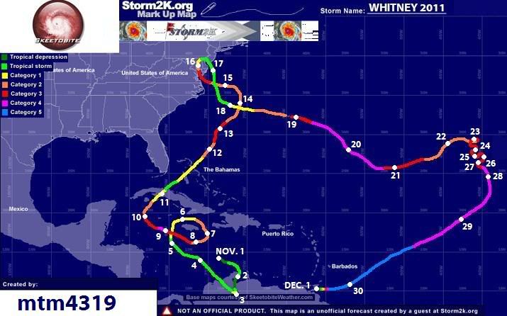
Haha. After looking at the newly-released 2011 name list, I imagined that Hurricane Whitney would have the most cracked-out track ever:

Image

Highlights:
November 3rd: Stalls in Lake Maracaibo, reaches Category 1 strength
November 5th-9th: Performs clockwise loop around Jamaica
November 11th: Second landfall on Cuba coast at Category 1 strength
November 16th: Travels the entire length of Chesapeake Bay, weaking from Cat 3 to tropical storm
November 23rd-28th: Makes odd zigzagging motion, strengthening to Cat 4 along the way
November 29th-30th: Strengthens to Category 5 and increases forward speed to 75 mph
December 1st: Abruptly slows to a halt and dissipates 10 miles east of Trinidad
0 likes   

User avatar
SouthFloridawx
S2K Supporter
S2K Supporter
Posts: 8346
Age: 46
Joined: Tue Jul 26, 2005 1:16 am
Location: Sarasota, FL
Contact:

#40 Postby SouthFloridawx » Fri Jun 16, 2006 6:09 am

At least you are using the colors properly.
0 likes   


Return to “Talkin' Tropics”

Who is online

Users browsing this forum: Hurricane2000 and 39 guests