Personal Hurricane Pictures/Video
Moderator: S2k Moderators
Forum rules

The posts in this forum are NOT official forecasts and should not be used as such. They are just the opinion of the poster and may or may not be backed by sound meteorological data. They are NOT endorsed by any professional institution or STORM2K. For official information, please refer to products from the National Hurricane Center and National Weather Service.
-
beachbum_al

- Category 5

- Posts: 2163
- Age: 55
- Joined: Thu Jul 14, 2005 9:23 pm
- Location: South Alabama Coast
- Contact:
-
O Town
- S2K Supporter

- Posts: 5205
- Age: 52
- Joined: Wed Sep 07, 2005 9:37 pm
- Location: Orlando, Florida 28°35'35"N 81°22'55"W
SouthFloridawx wrote:Wow Otown I didn't realize how bad it was in orlando for Charlie. I guess it just goes to prove just because you live in the middle of florida you still need to take precautions and get ready for the storm just as the rest of us along the coast. Didn't Charlie still have an eye as it moved over orlando?
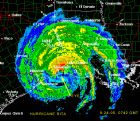
Pretty dern close, here is my old avatar you can see from the radar it was still holding together pretty well. It ripped a path of destruction right through Florida. I mean look how far away Orlando is from the landfall.

0 likes

All of Katrina in Biloxi... Of course, we now live in Madeira Beach, FL. Hopefully, we'll not see a repeat "here" anytime soon.
Our living room just as the water was coming in. We foolishly thought we could actually save some stuff by piling it up on the furniture. NOT!!

Outside my side door:

Outside my front door:

And a few more:

And our home there is at 19.5 feet ABOVE sea level!! Amazing indeed.
Our living room just as the water was coming in. We foolishly thought we could actually save some stuff by piling it up on the furniture. NOT!!
Outside my side door:
Outside my front door:
And a few more:
And our home there is at 19.5 feet ABOVE sea level!! Amazing indeed.
0 likes
-
MONTEGUT_LA

- Tropical Storm

- Posts: 105
- Joined: Sun Jul 20, 2003 7:29 pm
- Location: Montegut, Louisiana
To view my hurricane rita <MONTEGUT, LA> photos:
Click on Hurricane album.
http://photos.yahoo.com/tina_verrett
Some the photos are shots taking while driving so you not make some out.
Click on Hurricane album.
http://photos.yahoo.com/tina_verrett
Some the photos are shots taking while driving so you not make some out.
0 likes
-
cajungal

- Category 5
- Posts: 2344
- Age: 49
- Joined: Sun Mar 14, 2004 9:34 pm
- Location: Schriever, Louisiana (60 miles southwest of New Orleans)
Welcome Montegut to Storm2k! I am your neighbor here in Schriever! Amazing pictures. Sorry what you guys had to go through. You see what a storm can do to our parish of Terrebonne from a hurricane hitting 200 miles to our west. It just blows my mind to think what a direct hit would do to the Houma-Thibodaux area especially the Montegut area just to the south.
0 likes
-
MONTEGUT_LA
- Tropical Storm
- Posts: 105
- Joined: Sun Jul 20, 2003 7:29 pm
- Location: Montegut, Louisiana
We had about 3 feet in our house. If we ever get a direct hit, the lower end of the parish will most likely be washed away.
But I Love it down here!!!!!!
But I Love it down here!!!!!!
0 likes
::::::Danny & Juan '85, Andrew '92, Lili '02, Katrina & Rita '05, Gustav & Ike '08, Isaac '12, Ida 2021::::::
::::It's been a wild ride, but you just gotta love living on the gulf coast!::::
::::It's been a wild ride, but you just gotta love living on the gulf coast!::::
-
beachbum_al
- Category 5
- Posts: 2163
- Age: 55
- Joined: Thu Jul 14, 2005 9:23 pm
- Location: South Alabama Coast
- Contact:
http://pg.photos.yahoo.com/ph/beachbum1970al/album?.dir=/a4a5re2&.src=ph
I will try to add the pics of Katrina later.
I will try to add the pics of Katrina later.
0 likes
-
SouthFloridawx

- S2K Supporter
- Posts: 8346
- Age: 47
- Joined: Tue Jul 26, 2005 1:16 am
- Location: Sarasota, FL
- Contact:
beachbum_al wrote:http://pg.photos.yahoo.com/ph/beachbum1970al/album?.dir=/a4a5re2&.src=ph
I will try to add the pics of Katrina later.
Ya know I was in Orange Beach about a month and a half ago but, only for like a day. It seems like they are recovering there quickly and have thier act together. I love those beaches by the way.
0 likes
-
beachbum_al
- Category 5
- Posts: 2163
- Age: 55
- Joined: Thu Jul 14, 2005 9:23 pm
- Location: South Alabama Coast
- Contact:
Here's a few of the photos I took after Hurricane Charley of my neighborhood in Seminole County about 20 miles north of Orlando:
My backyard after the storm:

my neighbor's house:

tree on house in my neighborhood:


Blocked street in Casselberry, my home-town:

FRANCES:
Fallen tree on my street after Hurricane Frances:

--Lou
My backyard after the storm:
my neighbor's house:
tree on house in my neighborhood:
Blocked street in Casselberry, my home-town:
FRANCES:
Fallen tree on my street after Hurricane Frances:
--Lou
0 likes
-
Extremeweatherguy

- Category 5
- Posts: 11095
- Joined: Mon Oct 10, 2005 8:13 pm
- Location: Florida
For those looking at these charley pictures amazed and wanting to know how strong the sustained winds were in central FL, here is a map of them (from the NWS):
http://www.srh.noaa.gov/mlb/charley/cha ... dswath.jpg
-The hardest hit areas of Polk and Osceola counties saw Cat. 2 force winds.
-The hardest hit areas of Orange Co. saw Cat. 1 (possible Cat. 2 force in a small pocket of SW Orange Co.) force winds.
-The hardest hit areas of Seminole county saw Cat. 1 force winds.
-The hardest hit areas of Volusia county saw strong TS/Cat. 1 force winds.
**gusts in these counties were a category or two higher.**
Estimated top gusts per county:
Polk: 110-135mph
Osceola: 105-125mph
Orange: 100-115mph
Seminole: 90-105mph
Volusia: 85-100mph
0 likes
-
docjoe

- S2K Supporter
- Posts: 262
- Joined: Thu Sep 09, 2004 10:42 pm
- Location: SE Alabama..formerly the land of ivan and dennis
backyard after ivan...we had a storm surge come up the creek (which cant be seen) the creek rose up about 8-10feet. normally it is about 120 feet from the house but in this case was about 30 feet away. ultimately empties into blackwater bay which is where the surge came from. freshwater flooding also contributed
between Ivan and Dennis about 40+ trees went down. Dennis later got the roof and chimney

another ivan backyard

between Ivan and Dennis about 40+ trees went down. Dennis later got the roof and chimney
another ivan backyard
0 likes
-
JonathanBelles
- Professional-Met

- Posts: 11430
- Age: 35
- Joined: Sat Dec 24, 2005 9:00 pm
- Location: School: Florida State University (Tallahassee, FL) Home: St. Petersburg, Florida
- Contact:
Extremeweatherguy wrote:For those looking at these charley pictures amazed and wanting to know how strong the sustained winds were in central FL, here is a map of them (from the NWS):
http://www.srh.noaa.gov/mlb/charley/cha ... dswath.jpg
-The hardest hit areas of Polk and Osceola counties saw Cat. 2 force winds.
-The hardest hit areas of Orange Co. saw Cat. 1 (possible Cat. 2 force in a small pocket of SW Orange Co.) force winds.
-The hardest hit areas of Seminole county saw Cat. 1 force winds.
-The hardest hit areas of Volusia county saw strong TS/Cat. 1 force winds.
**gusts in these counties were a category or two higher.**
Estimated top gusts per county:
Polk: 110-135mph
Osceola: 105-125mph
Orange: 100-115mph
Seminole: 90-105mph
Volusia: 85-100mph
do you have that map for west central florida?
0 likes
-
invictus61101
- Tropical Wave

- Posts: 9
- Joined: Wed May 31, 2006 2:15 pm
- Location: Beaumont, TX
-
bvigal

- S2K Supporter
- Posts: 2276
- Joined: Sun Jul 24, 2005 8:49 am
- Location: British Virgin Islands
- Contact:
You guys, thanks for posting these pics, even though they made me cry again. Poor Biloxi, have been there many times, it breaks my heart! What is left of the historic downtown?
And driven through barrier island beaches in Panhandle, some of those places look familiar, too.
I'm so sorry for all you've been through!!!
And driven through barrier island beaches in Panhandle, some of those places look familiar, too.
I'm so sorry for all you've been through!!!
0 likes
-
jusforsean

- Category 1

- Posts: 395
- Joined: Wed Nov 09, 2005 8:22 am
- Location: South Florida


-
Scott_inVA

- Storm2k Forecaster

- Posts: 1238
- Joined: Sat Oct 12, 2002 5:44 pm
- Location: Lexington, Virginia
- Contact:
I have a request of anyone interested. While at WREL Radio I had a ton of hurricane pix sent from folks here at s2k and elsewhere. When the station sold they dumped anything not local  . When I launched Mid-Atlantic WX.com in 2004, I wanted to redo the photo gallery but a hard drive crash wiped out many pix I had planned to upload
Finally got a new one online and would like to upload any photos you want to share. The "how to" page is here: http://www.midatlanticwx.com/gallery_submit.htm
Photo Gallery is here: http://www.midatlanticwx.com/publicgall ... allery.htm
Attribution is given to anyone and I'd appreciate sharing some of these awesome photos. Thanks!
Scott
Mid-Atlantic WX.com
http://www.midatlanticwx.com/index.htm
Lexington, VA
0 likes
Who is online
Users browsing this forum: hcane27 and 132 guests