2:05 PM DISCO
CARIBBEAN SEA...
A BROAD UPPER LEVEL ANTICYCLONE IS CENTERED E OF THE LESSER
ANTILLES NEAR 14N55W WITH UPPER RIDGING STRETCHING WWARD TO 72W.
WESTERLY UPPER FLOW IS W OF THERE. NUMEROUS SHOWERS AND TSTMS
ARE ON THE SW PERIPHERY OF THE UPPER HIGH IN THE SW
CARIBBEAN...CURRENTLY S OF 16N AND W OF 72W. AN ILL-DEFINED 1009
MB SFC LOW IS LOCATED IN THIS BROAD AREA OF DISTURBED WEATHER
NEAR 11N78W. GFS IS FAIRLY AGGRESSIVE STRENGTHENING THIS LOW AND
TRACKING IT TO THE N WHILE OTHER COMPUTER MODELS ARE LESS
INTERESTED. SCATTERED SHOWERS AND TSTMS ARE OVER THE WINDWARD
ISLANDS TRIGGERED BY THE TROPICAL WAVE ALONG 60W/61W. THE
REMAINDER OF THE CARIBBEAN HAS BROKEN HIGH CLOUD CLOVER WITH
ONLY ISOLATED SHOWERS. TRADE WINDS ARE GENERALLY FROM 15-20 KT
AND WILL LIKELY REMAIN IN THAT RANGE TOMORROW.
GFS June 4 - 5 low crossing Cuba
Moderator: S2k Moderators
Forum rules

The posts in this forum are NOT official forecasts and should not be used as such. They are just the opinion of the poster and may or may not be backed by sound meteorological data. They are NOT endorsed by any professional institution or STORM2K. For official information, please refer to products from the National Hurricane Center and National Weather Service.
-
SouthFloridawx

- S2K Supporter

- Posts: 8346
- Age: 47
- Joined: Tue Jul 26, 2005 1:16 am
- Location: Sarasota, FL
- Contact:
-
JonathanBelles
- Professional-Met

- Posts: 11430
- Age: 35
- Joined: Sat Dec 24, 2005 9:00 pm
- Location: School: Florida State University (Tallahassee, FL) Home: St. Petersburg, Florida
- Contact:

I am not so concerned about rain as I am about flooding ......
Our island suffered greatly from the feeder bands off Wilma last fall...we had some terrible flooding here as a result.
Flooding is of immense concern to this island and much discussion centered around it at a Disaster Management Course I attended here on the island last week.
Thanks,
Gretchen
Our island suffered greatly from the feeder bands off Wilma last fall...we had some terrible flooding here as a result.
Flooding is of immense concern to this island and much discussion centered around it at a Disaster Management Course I attended here on the island last week.
Thanks,
Gretchen
0 likes

-
JonathanBelles
- Professional-Met
- Posts: 11430
- Age: 35
- Joined: Sat Dec 24, 2005 9:00 pm
- Location: School: Florida State University (Tallahassee, FL) Home: St. Petersburg, Florida
- Contact:

-
Stratusxpeye

- Category 2

- Posts: 686
- Joined: Tue Jun 07, 2005 10:40 am
- Location: Tampa, Florida
- Contact:
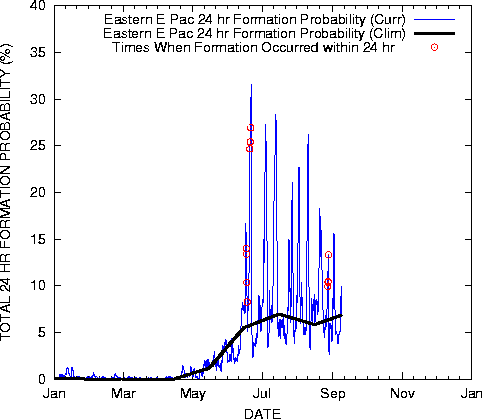
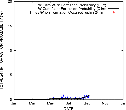
fact789 wrote:http://www.ssd.noaa.gov/PS/TROP/DATA/gparm/xyrfpr.gif
still only a .7% chance
Aren't these just theoretical images? I don't belive these to be quite accurate. Isnt this just like the maps for the maximum potential based on such things as water temp, shear in the area and climatology?
EPAC has 1-3% and there on the second system. One develping currently within this 1-3% area range.
0 likes
-
wxman57

- Moderator-Pro Met

- Posts: 23150
- Age: 68
- Joined: Sat Jun 21, 2003 8:06 pm
- Location: Houston, TX (southwest)
Ivan14 wrote:It certainly has potential to develop. Wind shear is low in the Caribbean and the water is definitely hot enough.
I never trust wind shear maps, as many models don't have a clue what the actual winds are over the troipcs. I do look at water vapor loops to get an idea of the wind fields aloft. Across the SW Caribbean, wind shear appears to be moderate and increasing as an upper-level low digs southeastward toward the region.
Chances for tropical development are quite low, but not impossible. However, any such development would be a very sheared TD or weak TS and would only threaten eastern Cuba and possibly Haiti with some rain by Monday.
0 likes
-
Weatherfreak000
wxman57 wrote:Ivan14 wrote:It certainly has potential to develop. Wind shear is low in the Caribbean and the water is definitely hot enough.
I never trust wind shear maps, as many models don't have a clue what the actual winds are over the troipcs. I do look at water vapor loops to get an idea of the wind fields aloft. Across the SW Caribbean, wind shear appears to be moderate and increasing as an upper-level low digs southeastward toward the region.
Chances for tropical development are quite low, but not impossible. However, any such development would be a very sheared TD or weak TS and would only threaten eastern Cuba and possibly Haiti with some rain by Monday.
I don't understand. I'm looking at the current Water Vapor loop and i'm seeing no moderate wind shear impacting the system. However, wind shear to the North of the disturbance looks a little strong but wouldn't that help increase the outflow and fan the system out?
I don't really understand the argument against wind shear maps. I thought them to be highly accurate and consistent. After all, these maps are what the NHC uses to determine the future of system's right? Also, shear looks to be on the decrease in all areas around the system and assuming it moves north to northwest this can only help it right?
I've seen this from here and here, also where is this upper level low you see? I can't determine how shear will be on the increase in this area...
0 likes
Stratusxpeye wrote:fact789 wrote:http://www.ssd.noaa.gov/PS/TROP/DATA/gparm/xyrfpr.gif
still only a .7% chance
Aren't these just theoretical images? I don't belive these to be quite accurate. Isnt this just like the maps for the maximum potential based on such things as water temp, shear in the area and climatology?
EPAC has 1-3% and there on the second system. One develping currently within this 1-3% area range.
You may be looking at the wrong block. The block that the invest is in (10°-15° N/100°-105° W) is showing 3-4% as is the block to the west of it. Also, compare the East Pacific east of 110° sub-basin and compare with the West Caribbean sub-basin.
0 likes
-
Stratusxpeye
- Category 2
- Posts: 686
- Joined: Tue Jun 07, 2005 10:40 am
- Location: Tampa, Florida
- Contact:
clfenwi wrote:You may be looking at the wrong block. The block that the invest is in (10°-15° N/100°-105° W) is showing 3-4% as is the block to the west of it. Also, compare the East Pacific east of 110° sub-basin and compare with the West Caribbean sub-basin.
You are correct. My point was just that these maps for maximum potential and maximum wind speed and development probability are not 100% dead on. Even if something is in 1% It still could form. That's all. GFS Has been very consistent with this system.
0 likes

-
CHRISTY
Here are 2 good loops of what the GFS is showing...see!
1)http://www.stormsurfing.com/cgi/display_alt.cgi?a=carib_slp
2)http://www.stormsurfing.com/cgi/display_alt.cgi?a=bahama_slp
1)http://www.stormsurfing.com/cgi/display_alt.cgi?a=carib_slp
2)http://www.stormsurfing.com/cgi/display_alt.cgi?a=bahama_slp
0 likes

-
wxman57
- Moderator-Pro Met
- Posts: 23150
- Age: 68
- Joined: Sat Jun 21, 2003 8:06 pm
- Location: Houston, TX (southwest)
Weatherfreak000 wrote:I don't understand. I'm looking at the current Water Vapor loop and i'm seeing no moderate wind shear impacting the system. However, wind shear to the North of the disturbance looks a little strong but wouldn't that help increase the outflow and fan the system out?
I don't really understand the argument against wind shear maps. I thought them to be highly accurate and consistent. After all, these maps are what the NHC uses to determine the future of system's right? Also, shear looks to be on the decrease in all areas around the system and assuming it moves north to northwest this can only help it right?
I've seen this from here and here, also where is this upper level low you see? I can't determine how shear will be on the increase in this area...
It's a fine line between enhancing outflow and producing unfavorable shear. I'm looking at a 48-hour loop and can see a sharp upper-level trof into the SW Caribbean that is very slowly lifting northward as another trof digs SE into the FL Panhandle (upper low over Midwest). So the digging trof into the NE Gulf is lifting out the trof over the SW Caribbean. This should have the effect of temporarily decrasing the shear but also decreasing the liifting to produce thunderstorms. It'll take a persistent concentration of squalls in one area to develop an LLC. That may be hard to come by.
As for the shear maps, they're only as good as the data that they're initialized with. I've looked at the GFS upper level wind maps many times then compared the flow to water vapor loops to find that the directions on the GFS output were 180 degrees off. There just isn't a lot of good data out over the oceans, so you have to be VERY careful trusting any upper-level wind forecasts (like shear maps) there. A good practice is to look at the 00hr upper wind map and compare it to the current WV loop to see how the model was initialized before even looking at the forecast.
Oh, and no, the NHC doesn't blindly use these shear maps. They know their weaknesses (as I've described above). The NHC forecasters would first make sure that the model being looked at appeard to initialize well.
0 likes
-
george_r_1961

- S2K Supporter
- Posts: 3171
- Age: 64
- Joined: Sat Oct 12, 2002 9:14 pm
- Location: Carbondale, Pennsylvania
Scorpion wrote:I disagree. Most people are on broadband. If you haven't caught on by now, its your loss. I have been on broadband for 5 years now.
Scorpion there are still many areas where broadband is NOT available and there are people out there that cannot afford it. We should all play by the rules so that everyone regardless of their connection speed can enjoy what the board has to offer.
0 likes
-
weatherwoman132

- Category 1

- Posts: 305
- Joined: Wed Mar 08, 2006 7:26 pm
-
southerngale

- Retired Staff

- Posts: 27418
- Joined: Thu Oct 10, 2002 1:27 am
- Location: Southeast Texas (Beaumont area)
george_r_1961 wrote:Scorpion wrote:I disagree. Most people are on broadband. If you haven't caught on by now, its your loss. I have been on broadband for 5 years now.
Scorpion there are still many areas where broadband is NOT available and there are people out there that cannot afford it. We should all play by the rules so that everyone regardless of their connection speed can enjoy what the board has to offer.
George, I can only assume that some of the kids today don't realize that broadband hasn't been around forever, nor is it available for everyone. While cable has been available where I live for 3 years now and I got it immediately, DSL wasn't available until they ran the new lines after Rita. I know a lot of people across the country who don't have either available. Some people just don't think before speaking.
0 likes
Who is online
Users browsing this forum: wwizard and 151 guests