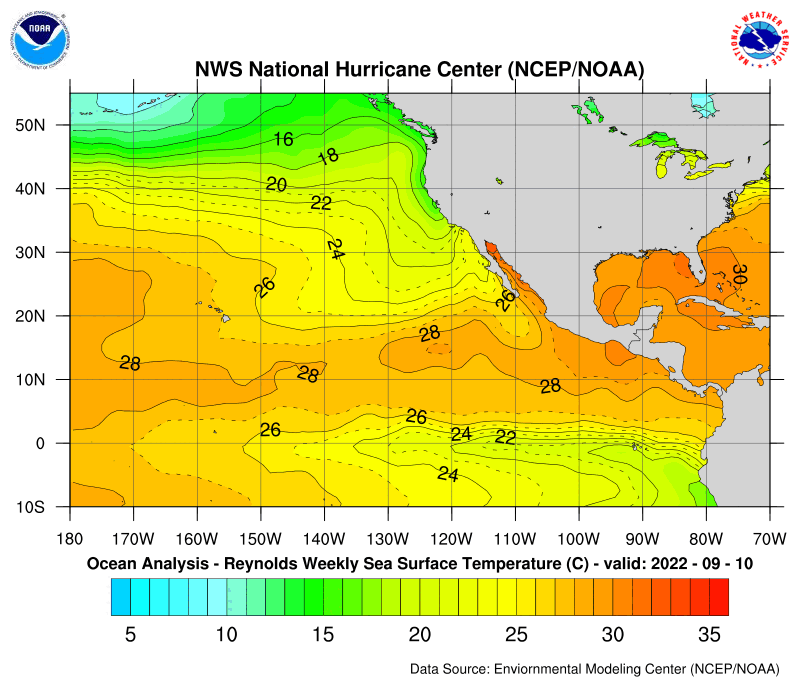
SSTs are definitely warm enough.
http://www.nhc.noaa.gov/tafb/pac_anal.gif
92E Invest at EPAC,Comments,Sat Pics,Models Thread
Moderator: S2k Moderators
Forum rules

The posts in this forum are NOT official forecasts and should not be used as such. They are just the opinion of the poster and may or may not be backed by sound meteorological data. They are NOT endorsed by any professional institution or STORM2K. For official information, please refer to products from the National Hurricane Center and National Weather Service.
-
wx247

- S2K Supporter

- Posts: 14279
- Age: 42
- Joined: Wed Feb 05, 2003 10:35 pm
- Location: Monett, Missouri
- Contact:
0 likes
Personal Forecast Disclaimer:
The posts in this forum are NOT official forecast and should not be used as such. They are just the opinion of the poster and may or may not be backed by sound meteorological data. They are NOT endorsed by any professional institution or storm2k.org. For official information, please refer to the NHC and NWS products.
The posts in this forum are NOT official forecast and should not be used as such. They are just the opinion of the poster and may or may not be backed by sound meteorological data. They are NOT endorsed by any professional institution or storm2k.org. For official information, please refer to the NHC and NWS products.

wxmann_91 wrote:There's a pretty strong 200 mb anticyclone over this developing system. If it develops it could be a small but potent system. Anybody have SST, Heat Content, and Max Intensity for this region?
http://cimss.ssec.wisc.edu/tropic/real- ... 10shr.html
Eastern Pacific Maximum Potential Intensity
Eastern Pacific SST
Eastern Pacific TCHP
0 likes
wxmann_91 wrote:There's a pretty strong 200 mb anticyclone over this developing system. If it develops it could be a small but potent system. Anybody have SST, Heat Content, and Max Intensity for this region?
SSTs
(almost 30 degrees C)
26-degree isotherm as of 5/28/06
(40-60 meters)
Hurricane Heat Potential
(25-30 kcal/cm2)
0 likes

-
JonathanBelles
- Professional-Met

- Posts: 11430
- Age: 35
- Joined: Sat Dec 24, 2005 9:00 pm
- Location: School: Florida State University (Tallahassee, FL) Home: St. Petersburg, Florida
- Contact:
fact789 wrote:what's a hurricane heat potential mean?
It's the amount of energy that is available for the hurricane to take from the sea.
It's calculated by taking the average temperature of the water from the surface down to the level where there is 26° C water and multiplying that by the depth of the 26 ° water, the specific heat capacity of water, and the density of water.
So, the higher the value, the more energy that is available for the hurricane.
"Hurricane Heat Potential of the Gulf of Mexico" is the paper that describes this and is pretty comprehensible as far as those sort of things go (it's the second hit for the phrase via Google).
0 likes
Special Feature in the TWD!
...SPECIAL FEATURE...
LOW PRES NEAR 11N103W 1007 MB WAS MOVING NW 10 KT. INFRARED
SATELLITE IMAGERY INDICATES INCREASED ORGANIZATION TO THE AREA
OF SCATTERED MODERATE/STRONG CONVECTION WHICH IS WITHIN 240 NM
OF THE WESTERN SEMICIRCLE OF THE LOW...GENERALLY FROM 9N TO 14N
BETWEEN 103W AND 108W. THIS CONVECTION HAS ACQUIRED SOME
BANDING CHARACTERISTICS AND DVORAK CLASSIFICATIONS MAY BE
STARTED WITHIN THE NEXT 6-12 HOURS ON THIS SYSTEM. AT THE UPPER
LEVELS AN UPPER LEVEL ANTICYCLONE JUST TO THE NORTH OF THE
SYSTEM IS PROVIDING A FAVORABLE ENVIRONMENT FOR FURTHER
DEVELOPMENT AND THIS SYSTEM HAS THE POTENTIAL TO BECOME A
TROPICAL CYCLONE OVER THE NEXT 36 HOURS OR SO.
0 likes

-
wx247
- S2K Supporter
- Posts: 14279
- Age: 42
- Joined: Wed Feb 05, 2003 10:35 pm
- Location: Monett, Missouri
- Contact:
TROPICAL WEATHER OUTLOOK
NWS TPC/NATIONAL HURRICANE CENTER MIAMI FL
1000 PM PDT THU JUN 1 2006
FOR THE EASTERN NORTH PACIFIC...EAST OF 140 DEGREES WEST LONGITUDE..
A LARGE AREA OF DISTURBED WEATHER...PRIMARILY ASSOCIATED WITH A
TROPICAL WAVE...IS CENTERED AROUND 350 MILES SOUTH-SOUTHWEST OF
ACAPULCO MEXICO. THIS SYSTEM CONTINUES TO BECOME BETTER ORGANIZED...
AND CONDITIONS APPEAR TO BE FAVORABLE FOR A TROPICAL DEPRESSION TO
FORM OVER THE NEXT DAY OR SO AS THE SYSTEM DRIFTS TOWARD THE NORTH
OR NORTHWEST.
ELSEWHERE...TROPICAL STORM FORMATION IS NOT EXPECTED THROUGH
SATURDAY.
FORECASTER MAINELLI/BEVEN
0 likes
Personal Forecast Disclaimer:
The posts in this forum are NOT official forecast and should not be used as such. They are just the opinion of the poster and may or may not be backed by sound meteorological data. They are NOT endorsed by any professional institution or storm2k.org. For official information, please refer to the NHC and NWS products.
The posts in this forum are NOT official forecast and should not be used as such. They are just the opinion of the poster and may or may not be backed by sound meteorological data. They are NOT endorsed by any professional institution or storm2k.org. For official information, please refer to the NHC and NWS products.
-
cycloneye

- Admin

- Posts: 148791
- Age: 69
- Joined: Thu Oct 10, 2002 10:54 am
- Location: San Juan, Puerto Rico
ABPZ20 KNHC 021010
TWOEP
TROPICAL WEATHER OUTLOOK
NWS TPC/NATIONAL HURRICANE CENTER MIAMI FL
400 AM PDT FRI JUN 2 2006
FOR THE EASTERN NORTH PACIFIC...EAST OF 140 DEGREES WEST LONGITUDE..
A LARGE AREA OF DISTURBED WEATHER IS CENTERED AROUND 400 MILES
SOUTH-SOUTHWEST OF ACAPULCO MEXICO. THIS SYSTEM CONTINUES TO BECOME
BETTER ORGANIZED...AND CONDITIONS APPEAR TO BE FAVORABLE FOR A
TROPICAL DEPRESSION TO FORM OVER THE NEXT DAY OR SO AS THE SYSTEM
DRIFTS TOWARD THE NORTH OR NORTHWEST.
ELSEWHERE...TROPICAL STORM FORMATION IS NOT EXPECTED THROUGH
SATURDAY.
FORECASTER MAINELLI/BEVEN
$$
0 likes
Visit the Caribbean-Central America Weather Thread where you can find at first post web cams,radars
and observations from Caribbean basin members Click Here
and observations from Caribbean basin members Click Here

-
cycloneye
- Admin
- Posts: 148791
- Age: 69
- Joined: Thu Oct 10, 2002 10:54 am
- Location: San Juan, Puerto Rico
GLOBAL MODEL DATA TIME 00UTC 02.06.2006
NEW TROPICAL STORM FORECAST TO DEVELOP AFTER 12 HOURS
FORECAST POSITION AT T+ 12 : 13.0N 100.0W
VERIFYING TIME POSITION STRENGTH TENDENCY
-------------- -------- -------- --------
12UTC 02.06.2006 13.0N 100.0W WEAK
00UTC 03.06.2006 15.6N 100.1W WEAK LITTLE CHANGE
12UTC 03.06.2006 15.2N 99.2W WEAK LITTLE CHANGE
00UTC 04.06.2006 15.0N 100.0W WEAK LITTLE CHANGE
12UTC 04.06.2006 15.6N 100.3W WEAK LITTLE CHANGE
00UTC 05.06.2006 15.5N 98.6W WEAK LITTLE CHANGE
12UTC 05.06.2006 14.2N 98.1W WEAK LITTLE CHANGE
00UTC 06.06.2006 15.1N 98.7W WEAK LITTLE CHANGE
12UTC 06.06.2006 14.8N 98.8W WEAK LITTLE CHANGE
00UTC 07.06.2006 14.8N 99.2W WEAK LITTLE CHANGE
12UTC 07.06.2006 14.7N 99.8W WEAK LITTLE CHANGE
00UTC 08.06.2006 15.1N 99.4W WEAK LITTLE CHANGE
00:00 UTC UKMET
0 likes
Visit the Caribbean-Central America Weather Thread where you can find at first post web cams,radars
and observations from Caribbean basin members Click Here
and observations from Caribbean basin members Click Here

-
HURAKAN

- Professional-Met
- Posts: 46086
- Age: 38
- Joined: Thu May 20, 2004 4:34 pm
- Location: Key West, FL
- Contact:
POSSIBLE TROPICAL CYCLONE FORMATION IN 36 HOURS
http://www.nhc.noaa.gov/tafb_latest/dan ... testBW.gif
http://www.nhc.noaa.gov/tafb_latest/dan ... testBW.gif
0 likes
-
cycloneye
- Admin
- Posts: 148791
- Age: 69
- Joined: Thu Oct 10, 2002 10:54 am
- Location: San Juan, Puerto Rico
I will be out of the net until mid afternoon which means,if this system is upgraded to a TD or a storm anyone can make a new thread with the following titles:
TD Two-E,Advisories,Comments,Sat Pics,Models Tread
TS Bud,Advisories,Comments,Sat Pics,Models Thread
TD Two-E,Advisories,Comments,Sat Pics,Models Tread
TS Bud,Advisories,Comments,Sat Pics,Models Thread
0 likes
Visit the Caribbean-Central America Weather Thread where you can find at first post web cams,radars
and observations from Caribbean basin members Click Here
and observations from Caribbean basin members Click Here
-
CHRISTY

-
wx247
- S2K Supporter
- Posts: 14279
- Age: 42
- Joined: Wed Feb 05, 2003 10:35 pm
- Location: Monett, Missouri
- Contact:
NRL estimates pressure at 1007 mb. Still 20 kts winds however. NE quadrant still looks a little rough, although there appears to be some convection firing there as we speak.
0 likes
Personal Forecast Disclaimer:
The posts in this forum are NOT official forecast and should not be used as such. They are just the opinion of the poster and may or may not be backed by sound meteorological data. They are NOT endorsed by any professional institution or storm2k.org. For official information, please refer to the NHC and NWS products.
The posts in this forum are NOT official forecast and should not be used as such. They are just the opinion of the poster and may or may not be backed by sound meteorological data. They are NOT endorsed by any professional institution or storm2k.org. For official information, please refer to the NHC and NWS products.

Who is online
Users browsing this forum: wwizard and 158 guests