
The following are images of Soufriere Hill's Volcano from the past year of renewed dome growth leading up to today's most recent dome collapse and major eruption:
Soufriere Hill's crater morphology prior to renewed dome growth - May 2005.
Morphology of crater after the appearance of the new lava dome and localised uplift - August 2005.
View of the crater floor showing evidence of uplift and fracturing - 11 August 2005.
View of the glowing dome at dawn - 19 January 2006.
View of incandescent rockfalls on the dome at night - 22 February 2006.
The volcano from a distance - 11 April 2006.
View of the lava dome inside the crater walls from the north east, ash rising from its surface and rockfalls - 27 April 2006.
View of dome, filling the entirety of Soufriere Hill's crater - 11 May 2006.
Another view of dome - 11 May 2006.
Another view of dome - 11 May 2006.
A broad spine 50m in diameter and 1006m high forms the highest point on the dome - 18 May 2006.
Volcanologists wait at the crater's periphery as equipment scan the dome surface - 18 May 2006.
View from remote camera of ash venting on the dome - 18 May 2006.
View of the volcano venting ash - 19 May 2006.
First image from a remote camera after today's most recent eruption - 20 May 2006.
Soufriere at Monserrat - Dome Collapse 11z-May 20
Moderator: S2k Moderators
Forum rules

The posts in this forum are NOT official forecasts and should not be used as such. They are just the opinion of the poster and may or may not be backed by sound meteorological data. They are NOT endorsed by any professional institution or STORM2K. For official information, please refer to products from the National Hurricane Center and National Weather Service.
-
whereverwx
- Category 5

- Posts: 1109
- Joined: Mon May 31, 2004 10:15 pm
-
cycloneye

- Admin

- Posts: 148792
- Age: 69
- Joined: Thu Oct 10, 2002 10:54 am
- Location: San Juan, Puerto Rico
Loop of Soufriere
Above is an impressive loop from the moment the eruption started and you can see how the big ash cloud spreads rapidly.
Above is an impressive loop from the moment the eruption started and you can see how the big ash cloud spreads rapidly.
0 likes
-
cycloneye
- Admin
- Posts: 148792
- Age: 69
- Joined: Thu Oct 10, 2002 10:54 am
- Location: San Juan, Puerto Rico
This is the first report that I haved seen today from the Island of Montserrat.It was posted at Caribbean Network site. http://stormcarib.com/index.htm#disc

Situation Report #1
Issued by: The Disaster Management Coordination Agency, Montserrat
Date: 20 May 2006
Scientific
The MVO reported that there were recorded signals of increased activity from
around six o`clock on Saturday 20th May 2006. Around 7.20 am the first dome
collapse with pyroclastic flows reached the sea at the end of Tar River Valley
on the eastern side of the island. The MVO also confirmed that flows went into
the Trants and Spanish Point areas.
There were confirmed reports of heavy ashing with accompanying small stones on
the north western side of the island especially in Salem, Olveston and Old
Towne areas.
The Impact
The Montserrat population is safe. Local residents were requested to remain
indoors, continue to execise caution and remain vigilant.
Major ash falls ? Vue Pointe Hotel had to move guests to Tropical Mansion
Suites due to the intensity of the ash and the high gas levels.
Salem covered with wet ash. Doctor Woods main road blocked.
Director MVO reported that Guadeloupe had a tsumani 1 meter high and an
unconfirmed report that Antigua also experienced a possible tsunami ranging
between 8 to 12 inches.
Health
Due to the high gas levels reported in Old Towne, Olveston, Salem and
surrounding areas, the local health authorities have recommended that residents
in these areas with specific health conditions such as asthma or any other
respiratory problems move northwards for a few hours.
General
The Emergency Operations Center (EOC) has been activated and the Authorities
are in constant contact with the Montserrat Volcano Observatory.
The EOC is keeping the public informed as the situation unfolds and will issue
further updates throughout the day.
Contact:
The Disaster Management Coordination Agency
Government of Montserrat
Yellow Hill Road
St. John's
Montserrat
Tel. (664) 491-7166
Fax. (664) 491-7003
email. dmca at gov.ms
Last edited by cycloneye on Sat May 20, 2006 6:37 pm, edited 1 time in total.
0 likes
Visit the Caribbean-Central America Weather Thread where you can find at first post web cams,radars
and observations from Caribbean basin members Click Here
and observations from Caribbean basin members Click Here

-
meteorologyman
- Category 2

- Posts: 541
- Joined: Wed Mar 15, 2006 6:48 pm
- Location: Florida, Kissimmee/St.CLoud
meteorologyman wrote:has this eruption change SST in any way or our climate
No, this eruption was one of Soufiere Hill's bigger exhalations of the past 10 years; however, it was very small compared to the magnitude required to induce a negligible effect on climate. As for SSTs, a volcanic eruption is not capable of directly affecting ocean temperatures unless it is large enough to affect global climate for a given year(s). In which case, a large enough eruption can inject enough particulate matter into the atmosphere, block out sunlight, thus lowering average SST globally. The last single volcanic event that was large enough to affect global temperatures was produced by Mount Pinatubo-Phillipines, 1991. The following is an excerpt on how the Pinatubo event was large enough to affect global temperatures:
The 1991 plinian eruption of Mount Pinatubo (15N, 120E) produced 5-10 cubic km of dacitic pumice fall and ignimbrite ( Scott et al., in press) and is arguably the second largest eruption of this century ( Self et al., in press). Most of the magma was erupted in a 9-hr climactic phase on June 15, culminating in the formation of a 2.5 km diameter caldera. Eruption columns exceeded an altitude of 35 km ( Lynch and Stevens, in press) and formed a giant umbrella cloud that injected 17x10 kg of SO into the stratosphere ( Bluth et al., 1992; Read et al., 1993), about twice the amount produced by the 1982 El Chichón eruption. This SO is believed to have come from a water-rich magmatic fluid that exsolved from the magma during pre-eruption evolution ( Westrich and Gerlach, 1992), rather than directly from the erupted melt. The SO formed about 25-30x10 kg of sulfate (HSO) aerosols, which produced the largest perturbation to the stratospheric aerosol layer since the eruption of Krakatau in 1883 ( McCormick and Veiga, 1992; Sato et al., 1993).
The aerosol cloud spread rapidly around the Earth in about three weeks and attained global coverage after about 1 year. The dense aerosol cloud caused dramatic decreases in the amount of net radiation reaching the earth's surface, producing a climate forcing two times stronger than the aerosols of El Chichón ( Angell and Korshover, 1983). Resultant climate effects included a 0.5-0.6C surface cooling in the northern hemisphere, equivalent to a hemispheric-wide reduction in net radiation of 4 Wm ( Dutton and Christy, 1992; Russell et al., 1993; Minnis et al., 1993) and a cooling of perhaps as much as -0.4C over large parts of the earth in 1992-1993 ( Hansen et al., 1992, 1993). The Pinatubo climate forcing was stronger than the opposing, warming effects of either the El Niño event or anthropogenic greenhouse gases in the period 1991-1993.
0 likes


-
bvigal

- S2K Supporter

- Posts: 2276
- Joined: Sun Jul 24, 2005 8:49 am
- Location: British Virgin Islands
- Contact:
That situation report originates from the Caribbean Disaster Emergency Response Agency - a non-profit organization which handles coordination of emergency response and information disemination for most countries in the Eastern Caribbean, also Turks, Bahamas, and Belize.
Website: http://www.cdera.org/
Website: http://www.cdera.org/
0 likes
-
cycloneye
- Admin
- Posts: 148792
- Age: 69
- Joined: Thu Oct 10, 2002 10:54 am
- Location: San Juan, Puerto Rico
FVXX21 KNES 211100
VOLCANIC ASH ADVISORY
ISSUED: 2006MAY21/1059Z VAAC: WASHINGTON
VOLCANO: SOUFRIERE HILLS 1600-05
LOCATION: N1642 W06210 AREA: W_INDIES
SUMMIT ELEVATION: 3002 FT (915 M)
ADVISORY NUMBER: 2006/373
INFORMATION SOURCE: GOES-12. GFS WINDS. NAM WINDS.
VAFTAD.
ERUPTION DETAILS: DOME COLLAPSE PRODUCING HIGH
LEVEL ASH AT ABOUT 20/1100Z AND ONGOING LOW LEVEL
ASH EMISSIONS
OBS ASH DATE/TIME: 21/0945Z
OBS ASH CLOUD: SFC/FL070 15NM WIDE LINE BETWEEN
N1642 W06349 - N1638 W06207. ASH IS MOVING W 10
KNOTS. SFC/FL370 N1541 W07103 - N1508 W06740 -
N1013 W06541 - N1011 W06941 - N1308 W07251 - N1541
W07103 MOVING W 15-20 KNOTS.
FCST ASH CLOUD +6H: 21/1600Z SFC/FL070 10NM WIDE
LINE BETWEEN N1742 W06335 - N1638 W06208.
SFC/FL370 N1428 W07305 - N1425 W06929 - N0923
W06654 - N0907 W07137 - N1227 W07528 - N1428
W07305
FCST ASH CLOUD +12H: 21/2200Z SFC/FL070 10NM WIDE
LINE BETWEEN N1747 W06324 - N1717 W06307 - N1643
W06208. SFC/FL370 N1410 W07034 - N0859 W06826 -
N0818 W07225 - N1238 W07717 - N1407 W07426 - N1410
W07034
FCST ASH CLOUD +18H: 22/0400Z SFC/FL070 10NM WIDE
LINE BETWEEN N1723 W06326 - N1637 W06207.
SFC/FL370 NO VA EXP.
REMARKS: THE MOST RECENT MULTISPECTRAL IMAGERY
SUGGESTS THAT SOME ASH MIGHT BE AS FAR SOUTH AS
NORTHERN VENEZUELA. VAFTAD GUIDANCE DOES NOT
APPEAR TO ACCURATELY DEPICT CURRENT ASH
SITUATION. WHEN VISIBLE IMAGERY BECOMES AVAILABLE
WE WILL UPDATE. ...
NEXT ADVISORY: WILL BE ISSUED BY 2006MAY21/1700Z
NNNN
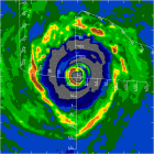
Latest advisory above.Still is throwiing low level ash although much less than yesterday.The big plume has reached northern Venezuela.Look at graphic below.
http://www.ssd.noaa.gov/VAAC/ARCHIVE/GFX/SOUF0373.jpg
VOLCANIC ASH ADVISORY
ISSUED: 2006MAY21/1059Z VAAC: WASHINGTON
VOLCANO: SOUFRIERE HILLS 1600-05
LOCATION: N1642 W06210 AREA: W_INDIES
SUMMIT ELEVATION: 3002 FT (915 M)
ADVISORY NUMBER: 2006/373
INFORMATION SOURCE: GOES-12. GFS WINDS. NAM WINDS.
VAFTAD.
ERUPTION DETAILS: DOME COLLAPSE PRODUCING HIGH
LEVEL ASH AT ABOUT 20/1100Z AND ONGOING LOW LEVEL
ASH EMISSIONS
OBS ASH DATE/TIME: 21/0945Z
OBS ASH CLOUD: SFC/FL070 15NM WIDE LINE BETWEEN
N1642 W06349 - N1638 W06207. ASH IS MOVING W 10
KNOTS. SFC/FL370 N1541 W07103 - N1508 W06740 -
N1013 W06541 - N1011 W06941 - N1308 W07251 - N1541
W07103 MOVING W 15-20 KNOTS.
FCST ASH CLOUD +6H: 21/1600Z SFC/FL070 10NM WIDE
LINE BETWEEN N1742 W06335 - N1638 W06208.
SFC/FL370 N1428 W07305 - N1425 W06929 - N0923
W06654 - N0907 W07137 - N1227 W07528 - N1428
W07305
FCST ASH CLOUD +12H: 21/2200Z SFC/FL070 10NM WIDE
LINE BETWEEN N1747 W06324 - N1717 W06307 - N1643
W06208. SFC/FL370 N1410 W07034 - N0859 W06826 -
N0818 W07225 - N1238 W07717 - N1407 W07426 - N1410
W07034
FCST ASH CLOUD +18H: 22/0400Z SFC/FL070 10NM WIDE
LINE BETWEEN N1723 W06326 - N1637 W06207.
SFC/FL370 NO VA EXP.
REMARKS: THE MOST RECENT MULTISPECTRAL IMAGERY
SUGGESTS THAT SOME ASH MIGHT BE AS FAR SOUTH AS
NORTHERN VENEZUELA. VAFTAD GUIDANCE DOES NOT
APPEAR TO ACCURATELY DEPICT CURRENT ASH
SITUATION. WHEN VISIBLE IMAGERY BECOMES AVAILABLE
WE WILL UPDATE. ...
NEXT ADVISORY: WILL BE ISSUED BY 2006MAY21/1700Z
NNNN
Latest advisory above.Still is throwiing low level ash although much less than yesterday.The big plume has reached northern Venezuela.Look at graphic below.
http://www.ssd.noaa.gov/VAAC/ARCHIVE/GFX/SOUF0373.jpg
0 likes
Visit the Caribbean-Central America Weather Thread where you can find at first post web cams,radars
and observations from Caribbean basin members Click Here
and observations from Caribbean basin members Click Here
-
cycloneye
- Admin
- Posts: 148792
- Age: 69
- Joined: Thu Oct 10, 2002 10:54 am
- Location: San Juan, Puerto Rico
Closeup Visible Image

You can see clearly at this closeup image that the ash still is comming out of the Soufriere as it is seen by the faint white to gray line streaming to the left of the island.But it is far less than what was occuring on Saturday when the big dome collapse occured.
You can see clearly at this closeup image that the ash still is comming out of the Soufriere as it is seen by the faint white to gray line streaming to the left of the island.But it is far less than what was occuring on Saturday when the big dome collapse occured.
0 likes
-
cycloneye
- Admin
- Posts: 148792
- Age: 69
- Joined: Thu Oct 10, 2002 10:54 am
- Location: San Juan, Puerto Rico
FVXX21 KNES 211207
VOLCANIC ASH ADVISORY
ISSUED: 2006MAY21/1206Z VAAC: WASHINGTON
VOLCANO: SOUFRIERE HILLS 1600-05
LOCATION: N1642 W06210 AREA: W_INDIES
SUMMIT ELEVATION: 3002 FT (915 M)
ADVISORY NUMBER: 2006/374
INFORMATION SOURCE: GOES-12. GFS WINDS.
ERUPTION DETAILS: DOME COLLAPSE 20/1100Z AND
ONGOING EMISSIONS
OBS ASH DATE/TIME: 21/1115Z
OBS ASH CLOUD: SFC/FL070 25NM WIDE LINE BETWEEN
N1646 W06530 - N1644 W06211. ASH IS MOVING W 15-20
KNOTS. SFC/FL230 N1753 W06717 - N1658 W06556 -
N1622 W06515 - N1610 W06548 - N1556 W06606 - N1511
W06634 - N1414 W06520 - N1350 W06526 - N1411
W06631 - N1435 W06823 - N1433 W06958 - N1500
W07125 - N1547 W07123 - N1653 W07005 - N1711
W06925 - N1753 W06717 MOVING W 10 KNOTS. SFC/FL370
N1430 W07007 - N1353 W06554 - N1207 W06556 - N1044
W06605 - N1110 W06955 - N1430 W07007 MOVING W
15-20 KNOTS.
FCST ASH CLOUD +6H: 21/1730Z SFC/FL230 N1810
W07042 - N1810 W06755 - N1347 W06735 - N1406
W07135 - N1810 W07042 SFC/FL370 N1426 W07141 -
N1414 W06830 - N1058 W06836 - N1108 W07152 - N1426
W07141 SFC/FL070 25NM WIDE LINE BETWEEN N1810
W06311 - N1643 W06208.
FCST ASH CLOUD +12H: 21/2330Z SFC/FL230 N1835
W07232 - N1823 W06847 - N1340 W06857 - N1405
W07327 - N1835 W07232 SFC/FL370 NO VA
EXP.SFC/FL070 25NM WIDE LINE BETWEEN N1820 W06307
- N1644 W06207.
FCST ASH CLOUD +18H: 22/0530Z SFC/FL230 N1850
W07447 - N1830 W07001 - N1350 W07022 - N1425
W07558 - N1850 W07447 SFC/FL070 25NM WIDE LINE
BETWEEN N1734 W06352 - N1641 W06208.
REMARKS: VISIBLE SATELLITE IMAGERY REVEALED A
LARGER AREAL COVERAGE OF ASH THAN PREVIOUSLY
ANALYSED. ASH TO FL370 WAS ALONG THE NORTHERN
COAST OF SOUTH AMERICA AND THE SOUTHERN CARIBBEAN.
ASH TO FL230 WAS SOUTH OF PUERTO RICO AND THE
DOMINICAN REPUBLIC. IN ADDITION ASH CONTINUES TO
BE EMITTED FROM THE VOLCANO AND A PLUME TO FL070
EXTENDED APPROXIMATELY 200 NMI TO THE WEST OF THE
SUMMIT AT 1115Z. ...TURK
NEXT ADVISORY: WILL BE ISSUED BY 2006MAY21/1800Z
NNNN
Above is the very latset advisory issued at 12:06z or 8:06 AM EDT.
Graphic
0 likes
latest update from Montserrat:
http://stormcarib.com/reports/current/montserrat.shtml
Montserrat volcano erupts but no major eruption likely
- 5/21/2006 8:07:43 AM
Olveston, Montserrat, May 21, 2006 - All is quiet this morning after
yesterday's eruption at the Soufriére Hills volcano calming fears of a
possible major eruption.
Activity at the volcano in the south of the island has returned to
"normal" or "background" activity according to reports from the
Montserrat Volcano Observatory.
The first 24 hours after an eruption are critical and largely determine
the potential path of the mountain.
Early yesterday morning the volcano erupted belching poisonous gases and
ash, covering a wide area in this tiny British Caribbean dependency. No
injuries or fatalities were reported.
The eruption occurred when a section of the volcano's dome, which has
been growing since last year, collapsed sending a pyroclastic flow down
the eastern side of the mountain. Ash rose 55,000 feet and some rained on
the town of Salem.
The event was followed by an eruption-induced localised rainstorm which
sent torrents of mud and rocks down the slopes.
Director of the Montserrat Volcano Observatory, Sue Loughlin, said the
volcanic eruption was both good and bad in that "although it's been an
unpleasant morning with ash falling all around, it was a good thing in
the near-term because it collapsed this growing lava dome into the sea.".
The Caribbean Disaster Emergency Response Agency reported that the action
of the pyroclastic flow on the sea generated tsunamis on Guadeloupe and
Antigua but this report could not be independently confirmed.
After centuries of being dormant, the Mount Soufriere volcano awakened,
killing 19 people, destroying the capital Plymouth and wreaking havoc and
devastation on the southern half of the island which remains an exclusion
zone. Just over half of the 12,000 population has left the Emerald Isle.
The remainder moved to the northern section of the island where a new
capital has been constructed.
The eruption comes one and a half weeks before general elections are due.
(Caribbean360.com)
0 likes

-
cycloneye
- Admin
- Posts: 148792
- Age: 69
- Joined: Thu Oct 10, 2002 10:54 am
- Location: San Juan, Puerto Rico
FVXX21 KNES 212339
VOLCANIC ASH ADVISORY
ISSUED: 2006MAY21/2339Z VAAC: WASHINGTON
VOLCANO: SOUFRIERE HILLS 1600-05
LOCATION: N1642 W06210 AREA: W_INDIES
SUMMIT ELEVATION: 3002 FT (915 M)
ADVISORY NUMBER: 2006/376
INFORMATION SOURCE: GOES-12. NAM WINDS. MONTSERRAT
OBSERVATORY.
ERUPTION DETAILS: CONTINUOUS LOW LEVEL EMISSION OF
GASES AND LIGHT ASH.
OBS ASH DATE/TIME: 21/2315Z
OBS ASH CLOUD: SFC/FL070 15NM WIDE LINE BETWEEN
N1728 W06227 - N1639 W06208. ASH IS MOVING N 10
KNOTS. SFC/FL150 N1742 W06744 - N1347 W06738 -
N1340 W07545 - N1732 W07509 - N1742 W06744 MOVING
W 20-30 KNOTS.
FCST ASH CLOUD +6H: 22/0530Z SFC/FL070 20NM WIDE
LINE BETWEEN N1726 W06235 - N1637 W06208.
SFC/FL150 NO VA EXP.
FCST ASH CLOUD +12H: 22/1130Z SFC/FL070 20NM WIDE
LINE BETWEEN N1733 W06304 - N1635 W06207.
FCST ASH CLOUD +18H: 22/1730Z SFC/FL070 20NM WIDE
LINE BETWEEN N1746 W06333 - N1635 W06206.
REMARKS: THERE CONTINUES TO BE A VERY FAINT AREA
OF REMNANT GASES AND POSSIBLE LIGHT ASH FROM
YESTERDAYS ERUPTION COVERING A LARGE AREA OF THE
CARIBBEAN SOUTH OF HISPANIOLA THAT CONTINUES TO
DISIPATE AND WILL LIKELY BE TO FAINT TO FOLLOW
SOON. THE OBSERVATORY CONTINUES TO REPORT A LOW
LEVEL EMISSION MOVING NORTH AND IN IMAGERY ITS
AROUND 42 NM LONG. THE PLUME MAY TURN A MORE
NORTHWEST TOWARDS MORNING. ...SWANSON
NEXT ADVISORY: WILL BE ISSUED BY 2006MAY22/0545Z
NNNN
Above is the latest advisory about the Soufriere volcano.
Graphic of ash plumes
The graphic above shows the ash plumes where they are now and what is the forecast of future movement of them.It seems that the wind direction will shift more Southeast putting the Virgin Islands and Puerto Rico on the track for some ash passage although not as thick as when it gets out of the Soufriere.
0 likes
-
cycloneye
- Admin
- Posts: 148792
- Age: 69
- Joined: Thu Oct 10, 2002 10:54 am
- Location: San Juan, Puerto Rico
http://www.ssd.noaa.gov/VAAC/ARCHIVE/SO ... 21147.html
Umm it looks like some of the ash is comming to Puerto Rico although not a solid plume by the time it arrives here.
Umm it looks like some of the ash is comming to Puerto Rico although not a solid plume by the time it arrives here.
0 likes
Visit the Caribbean-Central America Weather Thread where you can find at first post web cams,radars
and observations from Caribbean basin members Click Here
and observations from Caribbean basin members Click Here
-
bvigal
- S2K Supporter
- Posts: 2276
- Joined: Sun Jul 24, 2005 8:49 am
- Location: British Virgin Islands
- Contact:
I read every one of these advisories, every day. (They are emailed to me.) I don't know about the prediction elements, but we weren't supposed to have but just barely some for a while today. We had it all day, so thick you could smell it. And, right now a friend is spending the night (unexpectedly) in Puerto Rico because he couldn't get home to BVI on any flights tonight after our airport closed due to Soufriere dust making aviation unsafe!!! 
0 likes
-
Epsilon_Fan

- Category 1

- Posts: 353
- Joined: Fri Jan 13, 2006 1:03 pm
- Location: Charleston, SC

We had a rousing song fest at Dinghy Dock last evening, I don't know where I'm a gonna go when the volcano blows! We all voted on Culebra  Some heavy rain earlier in the day washed the sky some but it was back thicker than ever by sunset. We'll see what today brings. Hope your friend gets home soon bvigal!
0 likes
Who is online
Users browsing this forum: MarioProtVI, Team Ghost and 94 guests