SST'S and Anomalies in Atlantic #3
Moderator: S2k Moderators
Forum rules

The posts in this forum are NOT official forecasts and should not be used as such. They are just the opinion of the poster and may or may not be backed by sound meteorological data. They are NOT endorsed by any professional institution or STORM2K. For official information, please refer to products from the National Hurricane Center and National Weather Service.
-
WeatherEmperor
- S2K Supporter

- Posts: 4806
- Age: 41
- Joined: Thu Sep 04, 2003 2:54 pm
- Location: South Florida
-
HurricaneHunter914
- Category 5

- Posts: 4439
- Age: 32
- Joined: Fri Mar 10, 2006 7:36 pm
- Location: College Station, TX
-
SouthFloridawx

- S2K Supporter
- Posts: 8346
- Age: 47
- Joined: Tue Jul 26, 2005 1:16 am
- Location: Sarasota, FL
- Contact:
-
WeatherEmperor
- S2K Supporter
- Posts: 4806
- Age: 41
- Joined: Thu Sep 04, 2003 2:54 pm
- Location: South Florida
-
CHRISTY
-
Extremeweatherguy

- Category 5
- Posts: 11095
- Joined: Mon Oct 10, 2005 8:13 pm
- Location: Florida
Check out this link that compares the Atlantic sea surface temperatures of late April 2005 to late April 2006. Looking at these, another 20 storm+ year is certainly possible!
http://www.wunderground.com/blog/Savann ... amp=200604
^^From my now locked thread^^
0 likes
benny wrote:JamesFromMaine2 wrote:I could say this until I am blue in the face.. but SSTs in the Gulf during the heart of hurricane season are ALWAYS warm enough for hurricanes. Never fails. Doesn't matter whether the water temps are 84 or 88 or 90. You can get Cat 5 hurricanes with SSTs near 84F. anything beyond that is just a little something extra that I don't think the hurricane can use for maximum winds. It might chance how fast it develops... or the wind structure a little.. Wind shear controls the intensities of GOM hurricane, not instability...
I disagree with you! Yes maybe 84F SSTs are warm enough to support a cat 5 however I think you are underestimating the effects of SSTs! With Katrina and Rita it wasn't until they got over the Loop Current that they really started to explode Also Wilma was in warmer water then 84F when she exploded. Had they not been in such hot water I very much don't think they would have turned out to be the monsters they became!
People have a very short memory I'm afraid... the maximum hurricane occurance in the basin is n of puerto rico.. nowhere near the maximum SSTs or heat content. Now I didn't say it couldn't affect intensification rate.. but there have been plenty of hurricanes that intensified quickly (see Hugo 89, Georges 98, Isabel 03) over waters that were about 28C.. 83F or so. There was no loop current or particularly warm or deep water in its path. The atmosphere controls these things.. the ocean assists but it is a minor effect. Just my opinion of course... if the atmosphere isn't perfect the ocean isn't going to do squat to the hurricane. I think the loop current is more overblown that even global warming.
For further evidence.. look at the list of rapid intensifiers:
http://www.storm2k.org/phpbb2/viewtopic.php?t=84221
Not too many over the Gulf in the upper brackets. A lot more in the tropical Atlantic east of or just n of the lesser antilles. All atmosphere. The ocean just has to be warm enough to let it happen.
I would have to disagree Benny to some extent and Scorpion through up the graph that showed the impact potential of SST's.It was Derek that noted that had Katrina slide a little further W that some of the models were supporting an even lower pressure due to the SST enviroment.These were just models and whether it would of materialized as drastically as predicted we will never know but the fact that part of the equation was there relative to SST's is important.
0 likes


Javlin wrote:benny wrote:JamesFromMaine2 wrote:I could say this until I am blue in the face.. but SSTs in the Gulf during the heart of hurricane season are ALWAYS warm enough for hurricanes. Never fails. Doesn't matter whether the water temps are 84 or 88 or 90. You can get Cat 5 hurricanes with SSTs near 84F. anything beyond that is just a little something extra that I don't think the hurricane can use for maximum winds. It might chance how fast it develops... or the wind structure a little.. Wind shear controls the intensities of GOM hurricane, not instability...
I disagree with you! Yes maybe 84F SSTs are warm enough to support a cat 5 however I think you are underestimating the effects of SSTs! With Katrina and Rita it wasn't until they got over the Loop Current that they really started to explode Also Wilma was in warmer water then 84F when she exploded. Had they not been in such hot water I very much don't think they would have turned out to be the monsters they became!
People have a very short memory I'm afraid... the maximum hurricane occurance in the basin is n of puerto rico.. nowhere near the maximum SSTs or heat content. Now I didn't say it couldn't affect intensification rate.. but there have been plenty of hurricanes that intensified quickly (see Hugo 89, Georges 98, Isabel 03) over waters that were about 28C.. 83F or so. There was no loop current or particularly warm or deep water in its path. The atmosphere controls these things.. the ocean assists but it is a minor effect. Just my opinion of course... if the atmosphere isn't perfect the ocean isn't going to do squat to the hurricane. I think the loop current is more overblown that even global warming.
For further evidence.. look at the list of rapid intensifiers:
http://www.storm2k.org/phpbb2/viewtopic.php?t=84221
Not too many over the Gulf in the upper brackets. A lot more in the tropical Atlantic east of or just n of the lesser antilles. All atmosphere. The ocean just has to be warm enough to let it happen.
I would have to disagree Benny to some extent and Scorpion through up the graph that showed the impact potential of SST's.It was Derek that noted that had Katrina slide a little further W that some of the models were supporting an even lower pressure due to the SST environment.These were just models and whether it would of materialized as drastically as predicted we will never know but the fact that part of the equation was there relative to SST's is important.
Models can't even get a short-term forecast of intensity right.. so trusting them to handle intensity and structure change by only varying SST seems unwise to me. I would love to know why Ivan didn't get any deeper than it did.. it spent days and days over exceptionally warm/deep water and didn't get as intense as Katrina. I can't seem to differentiate between SSTs of 83/84 versus SSTs of 88 in a storm. We get a whole slew of storms at that intensity. Something really special happens to allow storms to reach Cat 5 status.. and SST is a small control in my opinion compared to atmospheric dynamics, like inner core stuff, outer wind strength or wind shear. Maybe it helps storms intensity faster by moistening/warming the low-levels by modifying cooler downdrafts. But really it is a bunch of handwaving. All I know is that Cat 5 hurricanes exist in waters near 28C and warmer. However there are plenty of hurricanes that make Cat 4 status over 29C water or greater yet never make Cat 5, despite really favorable shear conditions. What was going on there? The bottom line is that I will stick with the point that too much is made of the SST at depth.. it is not the panacea for intensity change.
0 likes
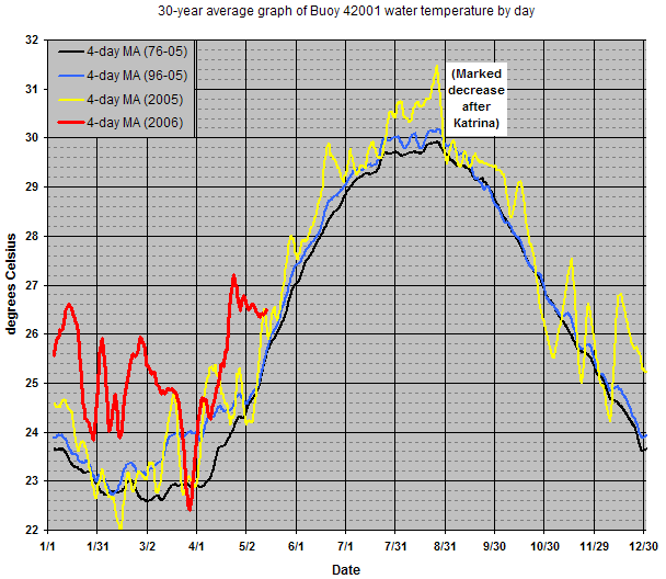
Buoy 42001 in the central Gulf has leveled off its record rates of warming in the past couple of weeks. The SST there now stands about on par with 2005, after being as much as 2.5 degrees Celsius warmer at the beginning of the month. This is nothing new -- a month ago, the temp was a degree C below the same time in 2005 -- but the trend will need to head back upward within the next two weeks to even be considered above average among the past 30 years.

(click for full size)
(click for full size)
0 likes
-
Aquawind

- Category 5
- Posts: 6714
- Age: 62
- Joined: Mon Jun 16, 2003 10:41 pm
- Location: Salisbury, NC
- Contact:
Models can't even get a short-term forecast of intensity right.. so trusting them to handle intensity and structure change by only varying SST seems unwise to me. I would love to know why Ivan didn't get any deeper than it did.. it spent days and days over exceptionally warm/deep water and didn't get as intense as Katrina. I can't seem to differentiate between SSTs of 83/84 versus SSTs of 88 in a storm. We get a whole slew of storms at that intensity. Something really special happens to allow storms to reach Cat 5 status.. and SST is a small control in my opinion compared to atmospheric dynamics, like inner core stuff, outer wind strength or wind shear. Maybe it helps storms intensity faster by moistening/warming the low-levels by modifying cooler downdrafts. But really it is a bunch of handwaving. All I know is that Cat 5 hurricanes exist in waters near 28C and warmer. However there are plenty of hurricanes that make Cat 4 status over 29C water or greater yet never make Cat 5, despite really favorable shear conditions. What was going on there? The bottom line is that I will stick with the point that too much is made of the SST at depth.. it is not the panacea for intensity change.
SSTs are important but still a small portion of the equation. The depth of the water is not important unless the system is massive and slow. It is important for numerous storms to intensify over the same waters. Last year was unique in that we had systems passing over the same waters without hindering development and it seemed like every blob organised. We had some real monsters move over the SE GOM and the temps can recover during such a long season if the systems are spaced apart adequately or small or moving quickly. SSTs are a small but important portion of the cat5 pie.
http://weather.unisys.com/hurricane/atl ... index.html
0 likes
Benny said.....I can't seem to differentiate between SSTs of 83/84 versus SSTs of 88 in a storm. We get a whole slew of storms at that intensity. Something really special happens to allow storms to reach Cat 5 status.. and SST is a small control in my opinion compared to atmospheric dynamics, like inner core stuff, outer wind strength or wind shear. Maybe it helps storms intensity faster by moistening/warming the low-levels by modifying cooler
Thats just it Benny it's a handfull of variables that make this happen and SST's just happens to one of them.Just because Ivan did not make it back up to Cat 5 status means that maybe one of the other variables was not present but the SST's where.Just because SST's are present does not mean we are going to have a CAT 5 just the possibility is there.I remember Max Mayfield showing in one the graphs how the warm loop current helped Katrina significantly in her delopment once in the GOM.It was in that graph that I saw the same data that Derek ahd basically supplied and further to Katrina's W was an even higher sst enviroment.Like I said earlier and you might of overlooked its part of the equation.
Thats just it Benny it's a handfull of variables that make this happen and SST's just happens to one of them.Just because Ivan did not make it back up to Cat 5 status means that maybe one of the other variables was not present but the SST's where.Just because SST's are present does not mean we are going to have a CAT 5 just the possibility is there.I remember Max Mayfield showing in one the graphs how the warm loop current helped Katrina significantly in her delopment once in the GOM.It was in that graph that I saw the same data that Derek ahd basically supplied and further to Katrina's W was an even higher sst enviroment.Like I said earlier and you might of overlooked its part of the equation.
0 likes
-
SouthFloridawx
- S2K Supporter
- Posts: 8346
- Age: 47
- Joined: Tue Jul 26, 2005 1:16 am
- Location: Sarasota, FL
- Contact:


Javlin wrote:Benny said.....I can't seem to differentiate between SSTs of 83/84 versus SSTs of 88 in a storm. We get a whole slew of storms at that intensity. Something really special happens to allow storms to reach Cat 5 status.. and SST is a small control in my opinion compared to atmospheric dynamics, like inner core stuff, outer wind strength or wind shear. Maybe it helps storms intensity faster by moistening/warming the low-levels by modifying cooler
Thats just it Benny it's a handfull of variables that make this happen and SST's just happens to one of them.Just because Ivan did not make it back up to Cat 5 status means that maybe one of the other variables was not present but the SST's where.Just because SST's are present does not mean we are going to have a CAT 5 just the possibility is there.I remember Max Mayfield showing in one the graphs how the warm loop current helped Katrina significantly in her delopment once in the GOM.It was in that graph that I saw the same data that Derek ahd basically supplied and further to Katrina's W was an even higher sst enviroment.Like I said earlier and you might of overlooked its part of the equation.
I don't have the figure, but I wish I had one that showed the intensity of Rita as it passed over the GOM. It showed the strengthening over the loop current.. then it passed over a cooler area... then it hit another warm eddy. However the storm was weakening while it was moving thru the warm eddy. It had no appreciable effect. If the ocean is going to do anything to help the storm.. it needs the atmosphere to cooperate. Frances in 04 was an example.. very deep warm water yet it was weakening. If you turn that around... no shear will allow a vortex to intensify to a major hurricane above 27-27.5C. That's it. 81-82 degrees. That's all you need. Almost everywhere meets that SST criteria in Sept. Yet MHs aren't popping up everywhere on every wave. That's why I say that SST is just overblown and is a second order factor. If the atmosphere is right with marginal SSTs.. you get a major hurricane. If the SSTs are really juicy with marginal shear.. you are lucky to get a hurricane. See Phillippe. I just wish I could convince people on here
0 likes
-
Jim Cantore
benny wrote:Javlin wrote:Benny said.....I can't seem to differentiate between SSTs of 83/84 versus SSTs of 88 in a storm. We get a whole slew of storms at that intensity. Something really special happens to allow storms to reach Cat 5 status.. and SST is a small control in my opinion compared to atmospheric dynamics, like inner core stuff, outer wind strength or wind shear. Maybe it helps storms intensity faster by moistening/warming the low-levels by modifying cooler
Thats just it Benny it's a handfull of variables that make this happen and SST's just happens to one of them.Just because Ivan did not make it back up to Cat 5 status means that maybe one of the other variables was not present but the SST's where.Just because SST's are present does not mean we are going to have a CAT 5 just the possibility is there.I remember Max Mayfield showing in one the graphs how the warm loop current helped Katrina significantly in her delopment once in the GOM.It was in that graph that I saw the same data that Derek ahd basically supplied and further to Katrina's W was an even higher sst enviroment.Like I said earlier and you might of overlooked its part of the equation.
I don't have the figure, but I wish I had one that showed the intensity of Rita as it passed over the GOM. It showed the strengthening over the loop current.. then it passed over a cooler area... then it hit another warm eddy. However the storm was weakening while it was moving thru the warm eddy. It had no appreciable effect. If the ocean is going to do anything to help the storm.. it needs the atmosphere to cooperate. Frances in 04 was an example.. very deep warm water yet it was weakening. If you turn that around... no shear will allow a vortex to intensify to a major hurricane above 27-27.5C. That's it. 81-82 degrees. That's all you need. Almost everywhere meets that SST criteria in Sept. Yet MHs aren't popping up everywhere on every wave. That's why I say that SST is just overblown and is a second order factor. If the atmosphere is right with marginal SSTs.. you get a major hurricane. If the SSTs are really juicy with marginal shear.. you are lucky to get a hurricane. See Phillippe. I just wish I could convince people on here
http://en.wikipedia.org/wiki/Image:Rita_wind.jpg
0 likes
-
HurricaneHunter914
- Category 5
- Posts: 4439
- Age: 32
- Joined: Fri Mar 10, 2006 7:36 pm
- Location: College Station, TX
http://image.weather.com/images/maps/tr ... 20x486.jpg
1/3 of the gulf is covered red. If there is supposed to be a cool down in this area it probably will last for a day and then it will bounce back to 80s.
1/3 of the gulf is covered red. If there is supposed to be a cool down in this area it probably will last for a day and then it will bounce back to 80s.
0 likes
-
Aquawind
- Category 5
- Posts: 6714
- Age: 62
- Joined: Mon Jun 16, 2003 10:41 pm
- Location: Salisbury, NC
- Contact:
http://www.aoml.noaa.gov/phod/cyclone/data/
http://www.aoml.noaa.gov/phod/cyclone/data/go.html
http://www.aoml.noaa.gov/phod/cyclone/data/at.html
NRL is telling me I am forbidden..ugh.
http://www.aoml.noaa.gov/phod/cyclone/data/go.html
http://www.aoml.noaa.gov/phod/cyclone/data/at.html
NRL is telling me I am forbidden..ugh.
0 likes
-
gatorcane

- S2K Supporter
- Posts: 23703
- Age: 47
- Joined: Sun Mar 13, 2005 3:54 pm
- Location: Boca Raton, FL
Looks like there is a slight cooling in the La Nina regions of the EPAC along the equator just off the South American coast based on the SST loop from the past week. Is this due to the trades starting to kick up in that region?
Has anybody seen this trend? Looks like La Nina may be a real possibility this year.
http://www.ssd.noaa.gov/PS/TROP/DATA/RT ... -loop.html
Has anybody seen this trend? Looks like La Nina may be a real possibility this year.
http://www.ssd.noaa.gov/PS/TROP/DATA/RT ... -loop.html
0 likes
Who is online
Users browsing this forum: No registered users and 35 guests