Bay of Bengal: VSCS Mala - Possible catastrophe for Myanmar

This is the general tropical discussion area. Anyone can take their shot at predicting a storms path.

Moderator: S2k Moderators

Forum rules

The posts in this forum are NOT official forecasts and should not be used as such. They are just the opinion of the poster and may or may not be backed by sound meteorological data. They are NOT endorsed by any professional institution or STORM2K. For official information, please refer to products from the National Hurricane Center and National Weather Service.

Help Support Storm2K
Message
Author
User avatar
JamesFromMaine2
Category 4
Category 4
Posts: 989
Joined: Tue Jul 19, 2005 1:38 am
Location: Portland Maine USA
Contact:

#181 Postby JamesFromMaine2 » Fri Apr 28, 2006 12:59 am

Derecho wrote:Actually the cloud tops are warming despite the eye becoming more distinct.

This both SSD and AODT Dvorak hasn't really been rising.


well then I would like to know what a rise of 4.5 to 5.5 with them saying it could be as high as 6.0 right now is!

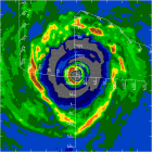
28/0230 UTC 14.7N 91.8E T5.5/5.5 MALA -- Bay of Bengal
WWIO20 KNES 280325
SATELLITE WEATHER BULLETIN
NORTH INDIAN OCEAN MET-5 VIS/IRDAY
.
APRIL 28 2006 0230Z
.
14.7N 91.8E T5.5/5.5/D1.5/24HRS MALA (02B)
.
PAST POSITIONS....13.1N 90.6E 27/1430Z IRNIGHT
12.4N 89.8E 27/0230Z VIS/IRDAY
.
REMARKS....SYSTEM HAS DEVELOPED AND WITH A CMG RING AND BLACK EYE
YIELDS A DT OF 6.0. MET HOWEVER IS 5.0 BUT PAT IS 6.0. SO SPLIT
THE DIFFERENCE AND GAVE FT 5.5.
.
POSITION ACCURATE WITHIN 30 NMI.
.
THE NEXT BULLETIN WILL BE ISSUED BY 28/1000Z
.
FOR AREAL DISPLAY OF RAINFALL POTENTIAL SEE OUR WEB SITE AT
HTTP://WWW.SSD.NOAA.GOV/PS/TROP/TRAP-IMG.HTML
ALL LOWER CASE LETTERS EXCEPT PS/TROP
.
GS
.
NNNN
http://www.ssd.noaa.gov/PS/TROP/positions.html
0 likes   

Matt-hurricanewatcher

#182 Postby Matt-hurricanewatcher » Fri Apr 28, 2006 3:33 am

Update 6#/2am pst/4-28-2006/Major cyclone Mala


Mala appears to have max in strength durning the last 3 hours. Data out of sab shows a 5.5/5.5=100 knots. On the other hand the eye has become more defined. In 85h data shows that there is a very small eye...Also the data shows that the system is going through a ewrc...Which it shows a outter eye. Shear maps shows that a upper ridge with a north and south outflow jet has formed. But on the other hand shear has increased over the cyclone at 5 to 10 knots...With only a small area of 10 knot shear over the center. The smaller eye likely has winds of 105 to 110 knots. So current winds are set at 110 knots.

With the upper level shear increasing+decreasing deep convection...It appears that the cyclone has maxed. In there is a good chance for a weaking...So a weaking should occur over the next 6 to 12 hours.

Track has been more or less to the east-northeast over the last 6 hours. In the cyclone will likely make landfall between 24 to 30 hours.

Wind forecast
0 110 knots
6 100 knots
12 90 knots
24 85 knots
30 50 knots inland
36 30 knots inland

Forecaster Matthew

This is not a offical forecast...
0 likes   

User avatar
JamesFromMaine2
Category 4
Category 4
Posts: 989
Joined: Tue Jul 19, 2005 1:38 am
Location: Portland Maine USA
Contact:

#183 Postby JamesFromMaine2 » Fri Apr 28, 2006 4:35 am

its now up to 115kts and 927mb pressure according to the navy site!

20060428.0900.meteo5.x.ir1km.02BMALA.115kts-927mb-148N-921E.100pc.jpg

also I think its now a 6.0
0 likes   

User avatar
Windspeed
Tropical Storm
Tropical Storm
Posts: 129
Joined: Thu Jun 10, 2004 11:38 am

#184 Postby Windspeed » Fri Apr 28, 2006 4:54 am

Mala is getting downright dangerous. Ironically, most of you (me included) spent last week googly-eyed over Monica's power; yet, this week presents a much more dangerous situation: Where as Monica was threatening only scarcely populated areas of the Northern Territory of Australia, Mala has some catastrophic potential if it does not weaken before landfall. Much of the coastline that lies ahead of this storm is densely populated.

Right now this storm is reminiscent of Charley and Opal. Storms that were wedged on the east side of moderate southwesterly flow in the lower and upper levels. Since the core is beginning to pick up forward speed in the same direction as the upperlevel flow, the core is being ventilated aloft by a rapid SW jet aloft. This is very condusive for rapid intensification, and the satellite presentation seems to confirm this scenario is underway. If this storm makes landfall around 920-935mb with a tight core, we're dealing with upper catagory 4 at landfall. Possibly even even a catagory 5 storm. If the core holds together and the pressure gradient remains tight and does not have time to expand, the wind damage from this storm will be similiar or greater than Charley at landfall. The best to hope for is that SW flow amplifies in the midlevels and undercuts the CDO, or the core falls apart during an eyewall replacement cycle and does not have the time to recover as it speed towards the NE imbedded in the southwesterly flow.

This is going to be a close call. I do not hype storms, but this one has horrid potential for extreme loss of life. I hope I am just overreacting.

Image
0 likes   

Matt-hurricanewatcher

#185 Postby Matt-hurricanewatcher » Fri Apr 28, 2006 6:13 am

OTTUZYUW RHHMFWCXXXX XXXXXXX-UUUU--RHMCSUU.
ZNR UUUUU
O 280751Z APR 06
FM NAVPACMETOCCEN PEARL HARBOR HI
TO AIG 9229
AL 9229
CTF 150
TF 150
PSBR BCST
BT
UNCLAS //N03145//
PASS TO OFFICE CODES:
PSBR BCST//SID 80//
DIRNSA FT GEORGE G MEADE MD//DDI-LIZ/P313/Q332/WWEA//
MSGID/GENADMIN/NAVPACMETOCCEN PEARL HARBOR HI/JTWC//
SUBJ/TROPICAL CYCLONE WARNING//
RMKS/
WTIO31 PGTW 280900
IMMEDIATE DELIVERY REQ TO AMCONSUL CALCUTTA AND AMEMBASSY DHAKA
1. TROPICAL CYCLONE 02B (MALA) WARNING NR 009
01 ACTIVE TROPICAL CYCLONE IN NORTHIO
MAX SUSTAINED WINDS BASED ON ONE-MINUTE AVERAGE
---
WARNING POSITION:
280600Z --- NEAR 14.8N 92.1E
MOVEMENT PAST SIX HOURS - 035 DEGREES AT 09 KTS
POSITION ACCURATE TO WITHIN 025 NM
POSITION BASED ON EYE FIXED BY SATELLITE
PRESENT WIND DISTRIBUTION:
MAX SUSTAINED WINDS - 115 KT, GUSTS 140 KT
RADIUS OF 064 KT WINDS - 030 NM NORTHEAST QUADRANT
030 NM SOUTHEAST QUADRANT
030 NM SOUTHWEST QUADRANT
030 NM NORTHWEST QUADRANT
RADIUS OF 050 KT WINDS - 050 NM NORTHEAST QUADRANT
050 NM SOUTHEAST QUADRANT
050 NM SOUTHWEST QUADRANT
050 NM NORTHWEST QUADRANT
RADIUS OF 034 KT WINDS - 105 NM NORTHEAST QUADRANT
100 NM SOUTHEAST QUADRANT
100 NM SOUTHWEST QUADRANT
105 NM NORTHWEST QUADRANT
REPEAT POSIT: 14.8N 92.1E
---
FORECASTS:
12 HRS, VALID AT:
281800Z --- 15.9N 93.0E
MAX SUSTAINED WINDS - 125 KT, GUSTS 150 KT
RADIUS OF 064 KT WINDS - 034 NM NORTHEAST QUADRANT
034 NM SOUTHEAST QUADRANT
034 NM SOUTHWEST QUADRANT
034 NM NORTHWEST QUADRANT
RADIUS OF 050 KT WINDS - 058 NM NORTHEAST QUADRANT
058 NM SOUTHEAST QUADRANT
057 NM SOUTHWEST QUADRANT
057 NM NORTHWEST QUADRANT
RADIUS OF 034 KT WINDS - 112 NM NORTHEAST QUADRANT
109 NM SOUTHEAST QUADRANT
108 NM SOUTHWEST QUADRANT
111 NM NORTHWEST QUADRANT
VECTOR TO 24 HR POSIT: 035 DEG/ 07 KTS
---
24 HRS, VALID AT:
290600Z --- 17.1N 93.9E
MAX SUSTAINED WINDS - 120 KT, GUSTS 145 KT
RADIUS OF 064 KT WINDS - 037 NM NORTHEAST QUADRANT
037 NM SOUTHEAST QUADRANT
036 NM SOUTHWEST QUADRANT
036 NM NORTHWEST QUADRANT
RADIUS OF 050 KT WINDS - 062 NM NORTHEAST QUADRANT
OVER WATER
062 NM SOUTHEAST QUADRANT
OVER WATER
060 NM SOUTHWEST QUADRANT
060 NM NORTHWEST QUADRANT
RADIUS OF 034 KT WINDS - 100 NM NORTHEAST QUADRANT
OVER WATER
100 NM SOUTHEAST QUADRANT
OVER WATER
114 NM SOUTHWEST QUADRANT
116 NM NORTHWEST QUADRANT
VECTOR TO 36 HR POSIT: 030 DEG/ 12 KTS
---
36 HRS, VALID AT:
291800Z --- 19.1N 95.2E
MAX SUSTAINED WINDS - 105 KT, GUSTS 130 KT
DISSIPATING AS A SIGNIFICANT TROPICAL CYCLONE OVER LAND
VECTOR TO 48 HR POSIT: 030 DEG/ 17 KTS
---
EXTENDED OUTLOOK:
48 HRS, VALID AT:
300600Z --- 22.0N 97.0E
MAX SUSTAINED WINDS - 070 KT, GUSTS 085 KT
DISSIPATING AS A SIGNIFICANT TROPICAL CYCLONE OVER LAND
---
REMARKS:
280900Z POSITION NEAR 15.1N 92.3E.
TROPICAL CYCLONE (TC) 02B (MALA), LOCATED APPROXIMATELY 260 NM WEST-
SOUTHWEST OF YANGON, MYANMAR, HAS TRACKED NORTHEASTWARD AT 09 KNOTS
OVER THE PAST 06 HOURS. RECENT ANIMATED MULTISPECTRAL IMAGERY REVEALS
TC 02B HAS CONTINUED TO INTENSIFY OVER THE PAST 12 HOURS. THE SYSTEM
HAS INCREASED SPEED TO THE NORTHEAST TOWARD THE COAST. THE OUTFLOW
CHANNELS CONTINUE TO VENT THE SYSTEM ALLOWING TC 02B TO INCREASE
INTENSITY THROUGH TAU 12. HOWEVER, AS THE SYSTEM MOVES OVER LAND
AROUND TAU 24, IT WILL RAPIDLY WEAKEN THROUGH THE REMAINDER OF THE
FORECAST. MAXIMUM SIGNIFICANT WAVE HEIGHT AT 280600Z IS 35 FEET. NEXT
WARNINGS AT 282100Z AND 290900Z.//

NNNN
0 likes   

no advance
Category 1
Category 1
Posts: 413
Joined: Wed Aug 24, 2005 1:50 pm
Location: merritt is.

#186 Postby no advance » Fri Apr 28, 2006 6:32 am

Lots of American surfers down in the Mentawais. Outer rain bands might keep them cool.
0 likes   

User avatar
stormtruth
Category 2
Category 2
Posts: 651
Joined: Thu Mar 16, 2006 4:15 pm

#187 Postby stormtruth » Fri Apr 28, 2006 6:33 am

HURAKAN wrote:Myanmar does not allow journalists into the country and maintains a strong hold on information disseminated in its state-run newspapers. This policy has created a difficult environment to gauge the lives affect by the tsunami.

LETS ALSO TAKE INTO ACCOUNT THAT MYANMAR WAS AFFECTED BY THE 2004 TSUNAMI THAT DEVASTATED THIS PART OF THE WORLD.


I guess we won't know what happens with Mala then if no journalists are allowed. :roll:
0 likes   

HurricaneHunter914
Category 5
Category 5
Posts: 4439
Age: 31
Joined: Fri Mar 10, 2006 7:36 pm
Location: College Station, TX

#188 Postby HurricaneHunter914 » Fri Apr 28, 2006 7:31 am

Very true, they should let journalists in because how is the world suppose to know how much this cyclone devestated the country?
0 likes   

HurricaneHunter914
Category 5
Category 5
Posts: 4439
Age: 31
Joined: Fri Mar 10, 2006 7:36 pm
Location: College Station, TX

#189 Postby HurricaneHunter914 » Fri Apr 28, 2006 7:35 am

http://maps.wunderground.com/data/images/ni200602.gif

According to wunderground they are expecting Mala to make landfall as a Cat-4. :eek:
0 likes   

User avatar
HURAKAN
Professional-Met
Professional-Met
Posts: 46086
Age: 38
Joined: Thu May 20, 2004 4:34 pm
Location: Key West, FL
Contact:

#190 Postby HURAKAN » Fri Apr 28, 2006 7:44 am

LETS LOCK THIS ONE, #2 IS OPEN TO CONTINUE THE COVERAGE.
0 likes   


Return to “Talkin' Tropics”

Who is online

Users browsing this forum: Cpv17, Tak5, wileytheartist and 70 guests