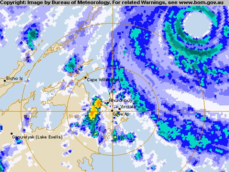
Cyclone Monica - Cat. 5
Moderator: S2k Moderators
- HURAKAN
- Professional-Met

- Posts: 46084
- Age: 39
- Joined: Thu May 20, 2004 4:34 pm
- Location: Key West, FL
- Contact:
CrazyC83 wrote:Now I see it...the Australian storms are so difficult to figure out since they use gusts to make estimates. Based on its really low pressure, I wouldn't be surprised if Carina really was a Category 5 - do they use Hurricane Hunters outside the Atlantic and EPAC?
Unfortunately, NO.
0 likes
- senorpepr
- Military Met/Moderator

- Posts: 12542
- Age: 43
- Joined: Fri Aug 22, 2003 9:22 pm
- Location: Mackenbach, Germany
- Contact:
CrazyC83 wrote:Now I see it...the Australian storms are so difficult to figure out since they use gusts to make estimates. Based on its really low pressure, I wouldn't be surprised if Carina really was a Category 5 - do they use Hurricane Hunters outside the Atlantic and EPAC?
CPAC and maybe WPAC if the DoD allows...
As for Aussie storms... they give sustained winds in the marine bulletins.
0 likes
-
Rod Hagen
- Tropical Storm

- Posts: 237
- Joined: Fri Sep 23, 2005 6:22 am
- Location: Lives in Melbourne, works in N Queensland
http://thestormtrack.com/archives/2006/ ... e_aus.html has a useful rough comparison chart of Australian and US categories
Cheers
Rod
Cheers
Rod
0 likes
http://cimss.ssec.wisc.edu/tropic/adt/odt26.html
UW - CIMSS
ADVANCED OBJECTIVE DVORAK TECHNIQUE
AODT - Version 6.4.2
Tropical Cyclone Intensity Algorithm
----- Current Analysis -----
Date : 23 APR 2006 Time : 023300 UTC
Lat : 11:28:40 S Lon : 137:37:17 E
CI# /Pressure/ Vmax
7.8 / 876.9mb/164.0kt
Latitude bias adjustment to MSLP : +10.5mb
Estimated radius of max. wind based on IR : 24.2km
6hr-Avg T# 3hr-Avg T# Adj T# Raw T#
7.7 7.8 7.9 7.9
Eye Temp : +19.4C Cloud Region Temp : -79.6C
that's getting into rarified air..
0 likes
http://www.cira.colostate.edu/ramm/rmsd ... pical.html
A loop is under MTSAT 1... IR pictures.. just remember to change the channel to #4 Enhanced IR
A loop is under MTSAT 1... IR pictures.. just remember to change the channel to #4 Enhanced IR
0 likes
http://www.nrlmry.navy.mil/tc-bin/tc_ho ... &SIZE=full
one of the strongest MI signatures I have ever seen..


one of the strongest MI signatures I have ever seen..
0 likes
-
Matt-hurricanewatcher
-
Matt-hurricanewatcher
- wxmann_91
- Category 5

- Posts: 8007
- Age: 34
- Joined: Fri Jul 15, 2005 2:49 pm
- Location: Southern California
- Contact:

One of the roundest CDO's and eye I've ever seen. (click on image to enlarge)
Benny, could you reduce that URL please?
Last edited by wxmann_91 on Sat Apr 22, 2006 10:55 pm, edited 1 time in total.
0 likes
Matt-hurricanewatcher wrote:This is stronger then 140 knots even if the cimss is a little -removed-. I say 150 knots/896 millibars.
Well, CIMSS isn't -removed-.. it is an objective method.. so there is no human behind it trying to make it stronger.. unlike this board at times
0 likes
Who is online
Users browsing this forum: No registered users and 8 guests


