Wind Shear Analysis in the Atlantic and Pacific

This is the general tropical discussion area. Anyone can take their shot at predicting a storms path.

Moderator: S2k Moderators

Forum rules

The posts in this forum are NOT official forecasts and should not be used as such. They are just the opinion of the poster and may or may not be backed by sound meteorological data. They are NOT endorsed by any professional institution or STORM2K. For official information, please refer to products from the National Hurricane Center and National Weather Service.

Help Support Storm2K
Message
Author
User avatar
gatorcane
S2K Supporter
S2K Supporter
Posts: 23693
Age: 47
Joined: Sun Mar 13, 2005 3:54 pm
Location: Boca Raton, FL

Wind Shear Analysis in the Atlantic and Pacific

#1 Postby gatorcane » Mon Apr 10, 2006 12:10 pm

Cycloneye has an ongoing thread regarding SST anomalies in the Atlantic and Pacific. While SSTs are very important to tropical activity, wind shear is equally as important as it prohibits storm formation.

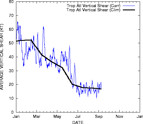
This thread will track wind shear across the Atlantic and Pacific basins as we approach the hurricane season. Contrary to SSTs which we will see rise dramatically over the next few months, we should see the wind shear start to relax.

Also, this thread will have all the various links/sources that will be handy for analyzing wind shear during the heart of hurricane season. I will post a few here right now:

These images update themselves and are provided by the University of Wisconsin's site: http://cimss.ssec.wisc.edu/tropic/

Image

Image

Image

Image
0 likes   

CHRISTY

#2 Postby CHRISTY » Mon Apr 10, 2006 12:32 pm

as far as the low pressure trying to develope around florida her is the forcast for shear for the next 72 hours out the red means low shear and the blue mean high shear.

http://www.wunderground.com/data/640x480/atlm_shear.gif
0 likes   

User avatar
gatorcane
S2K Supporter
S2K Supporter
Posts: 23693
Age: 47
Joined: Sun Mar 13, 2005 3:54 pm
Location: Boca Raton, FL

#3 Postby gatorcane » Mon Apr 10, 2006 12:57 pm

I think wind shear across the Atlantic and Pacific basins is looking pretty normal right now for this time of year.
0 likes   

User avatar
windycity
S2K Supporter
S2K Supporter
Posts: 461
Joined: Wed Aug 24, 2005 6:45 pm
Location: P.B.county,Fl.
Contact:

#4 Postby windycity » Mon Apr 10, 2006 3:45 pm

Thanks Boca Chris!!! Shear charts and SST charts, what more could a person hope for? Those are great, update daily so we dont have to look up info each time. You guys are making this too easy for us! :wink: :wink: :wink: :wink:
0 likes   

User avatar
benny
Category 2
Category 2
Posts: 593
Joined: Sun Mar 19, 2006 8:09 am
Location: Miami

#5 Postby benny » Mon Apr 10, 2006 5:44 pm

You can also track the wind shear and other genesis parameters at:

http://www.ssd.noaa.gov/PS/TROP/genesis.html

I would like at the timeseries to get a handle on where we are for this time of the year in regards to all sorts of parameters (including shear). In fact for the Eastern pacific you can see that little systems in the mid 120s that is showing a brief spike in the genesis probabilities.
0 likes   

User avatar
tailgater
S2K Supporter
S2K Supporter
Posts: 3339
Joined: Sun Jul 11, 2004 9:13 pm
Location: St. Amant La.

#6 Postby tailgater » Mon Apr 10, 2006 8:56 pm

Here's another site for some that might not have it.

http://cimss.ssec.wisc.edu/tropic/real- ... winds.html

I really like the wind shear tendency 5 day movie.
0 likes   

CHRISTY

#7 Postby CHRISTY » Mon Apr 10, 2006 10:45 pm

according to this map shear will be droping in the atlantic....

Image
0 likes   

CHRISTY

#8 Postby CHRISTY » Mon Apr 10, 2006 10:54 pm

look at this analysis of shear in the atlantic!

Image
Last edited by CHRISTY on Tue Apr 11, 2006 6:03 am, edited 1 time in total.
0 likes   

User avatar
benny
Category 2
Category 2
Posts: 593
Joined: Sun Mar 19, 2006 8:09 am
Location: Miami

#9 Postby benny » Mon Apr 10, 2006 11:43 pm

CHRISTY wrote:according to this map shear will be droping in the atlantic....

Image


Christy that is an analysis of shear not a forecast. The climo is of course dropping but as you will see as the season progresses the shear will only crudely follow that line. Also I think there is a 3 or 5 day running mean attached to the shear calculations... I'm not sure about that though. The only other point of note is that the tropical Atlantic goes down to the equator on that tropical Atlantic area... which I don't think is the best shear area calculation.
0 likes   

CHRISTY

#10 Postby CHRISTY » Wed Apr 12, 2006 12:33 pm

her is a update of the shear the red mean low shear and the bule mean high shaer

and look how low it is in the gulf!

Image
0 likes   

User avatar
benny
Category 2
Category 2
Posts: 593
Joined: Sun Mar 19, 2006 8:09 am
Location: Miami

#11 Postby benny » Wed Apr 12, 2006 5:07 pm

pretty darn low in the tropics. however.. this time of year there are no disturbances. :( plus the humidity aloft is too low..
0 likes   

User avatar
gatorcane
S2K Supporter
S2K Supporter
Posts: 23693
Age: 47
Joined: Sun Mar 13, 2005 3:54 pm
Location: Boca Raton, FL

#12 Postby gatorcane » Wed Apr 12, 2006 10:25 pm

great maps benny :)
0 likes   

User avatar
SouthFloridawx
S2K Supporter
S2K Supporter
Posts: 8346
Age: 46
Joined: Tue Jul 26, 2005 1:16 am
Location: Sarasota, FL
Contact:

#13 Postby SouthFloridawx » Tue Apr 18, 2006 6:53 pm

Atlantic Wind Summary from http://cimss.ssec.wisc.edu/tropic/tropic.html


Windshear Tend. 18 UTC 4-18-06

Image

Windshear 18UTC 4-18-06

Image

Steering Flow 700-850 hpa 18utc 4-18-06

Image

Steering Flow 250-850 hpa 18utc 4-18-06

Image

Windshear Forecast
Image
Last edited by SouthFloridawx on Tue Apr 18, 2006 7:11 pm, edited 1 time in total.
0 likes   

User avatar
benny
Category 2
Category 2
Posts: 593
Joined: Sun Mar 19, 2006 8:09 am
Location: Miami

#14 Postby benny » Tue Apr 18, 2006 6:57 pm

gee if we had a wave in the sw caribbean..
0 likes   

HurricaneHunter914
Category 5
Category 5
Posts: 4439
Age: 31
Joined: Fri Mar 10, 2006 7:36 pm
Location: College Station, TX

#15 Postby HurricaneHunter914 » Tue Apr 18, 2006 7:52 pm

It would probably die by the time it made it's way into the northern Carib, Benny. It seems like the shear is increasing more and more, a concern for the H-Season?
0 likes   

User avatar
benny
Category 2
Category 2
Posts: 593
Joined: Sun Mar 19, 2006 8:09 am
Location: Miami

#16 Postby benny » Tue Apr 18, 2006 8:06 pm

Hurricane Hunter 914 wrote:It would probably die by the time it made it's way into the northern Carib, Benny. It seems like the shear is increasing more and more, a concern for the H-Season?


I'm just hoping. It wasn't a forecast :) We would need a ton of moisture for sure cuz it is dry as a bone in the w carib. Any low shear this time of year is nice to see... it doesn't tend to last.
0 likes   

User avatar
benny
Category 2
Category 2
Posts: 593
Joined: Sun Mar 19, 2006 8:09 am
Location: Miami

#17 Postby benny » Sat Apr 22, 2006 10:44 am

Some might find this graphic useful. It is a graphic of forecast shear conditions for a long term period.. ie 3 months. It shows the negative values (less shear) forecast over the tropical Atlc/Caribbean for ASO... at least it did on Apr 22 ;)


Image
0 likes   

User avatar
hicksta
Category 5
Category 5
Posts: 1108
Age: 35
Joined: Thu Jul 14, 2005 12:16 am
Location: Kemah Texas/ Baton Rogue LA

#18 Postby hicksta » Sat Apr 22, 2006 10:51 am

Shear stay the whole yeaR!!
0 likes   

User avatar
Aquawind
Category 5
Category 5
Posts: 6714
Age: 62
Joined: Mon Jun 16, 2003 10:41 pm
Location: Salisbury, NC
Contact:

#19 Postby Aquawind » Sat Apr 22, 2006 11:02 am

Shear is our friend.. 8-)
0 likes   

HurricaneHunter914
Category 5
Category 5
Posts: 4439
Age: 31
Joined: Fri Mar 10, 2006 7:36 pm
Location: College Station, TX

#20 Postby HurricaneHunter914 » Sat Apr 22, 2006 11:36 am

Smeagle loves shear.
0 likes   


Return to “Talkin' Tropics”

Who is online

Users browsing this forum: CourierPR, Hurricaneman and 67 guests