Doomsday storms
Moderator: S2k Moderators
Forum rules

The posts in this forum are NOT official forecasts and should not be used as such. They are just the opinion of the poster and may or may not be backed by sound meteorological data. They are NOT endorsed by any professional institution or STORM2K. For official information, please refer to products from the National Hurricane Center and National Weather Service.
-
cheezyWXguy

- Category 5

- Posts: 6246
- Joined: Mon Feb 13, 2006 12:29 am
- Location: Dallas, TX
-
cheezyWXguy
- Category 5
- Posts: 6246
- Joined: Mon Feb 13, 2006 12:29 am
- Location: Dallas, TX
Hurricane Floyd wrote:Post it on ether
http://www.photobucket.com
or http://www.imageshack.com
Post it there first
I'd probably use imageshck but im not quite sure how(Im not too good w/ computers
0 likes
-
wxmann_91

- Category 5
- Posts: 8013
- Age: 34
- Joined: Fri Jul 15, 2005 2:49 pm
- Location: Southern California
- Contact:
This is the right link for Imageshack
Just click Browse and a window will open and that will allow you to browse your hard drive and whatever images are inside it. Click on the image you want to upload and click "open". Then click "Host it!", there will be code that will allow you to put the picture onto the forum.
Just click Browse and a window will open and that will allow you to browse your hard drive and whatever images are inside it. Click on the image you want to upload and click "open". Then click "Host it!", there will be code that will allow you to put the picture onto the forum.
0 likes
-
cheezyWXguy
- Category 5
- Posts: 6246
- Joined: Mon Feb 13, 2006 12:29 am
- Location: Dallas, TX

-
Hybridstorm_November2001

- S2K Supporter

- Posts: 2817
- Joined: Sat Aug 21, 2004 2:50 pm
- Location: SW New Brunswick, Canada
- Contact:

-
Hybridstorm_November2001
- S2K Supporter
- Posts: 2817
- Joined: Sat Aug 21, 2004 2:50 pm
- Location: SW New Brunswick, Canada
- Contact:


-
Extremeweatherguy

- Category 5
- Posts: 11095
- Joined: Mon Oct 10, 2005 8:13 pm
- Location: Florida
this actually narrowly misses Galveston a bit to the southwest, but even so; Galveston would likely see Cat. 3-4 force winds and a HUGE surge and downtown Houston would likely see Cat. 1-2 force winds (Similar to Wilma in Miami). This would be, of course, horrible; but a direct hit to Galveston and Houston would be much worse as winds on Galveston would likely reach Cat. 5 strength and in downtown Houston they would likely top near weak Cat. 3 strength.vbhoutex wrote:cheezywxman wrote:
Lanfall in Ft. Lauderdale- 150mph
Landfall in Galveston -165mph
Top Strength-180mph
Minimum pressure-883mb
Total Cost-150-250 billion
Cheezy take it back!!!! We don't want it!!!!!
0 likes
 [/img]


-
Jim Cantore
-
MiamiensisWx
If a hypercane happened like this, there would be total devastation potentially...
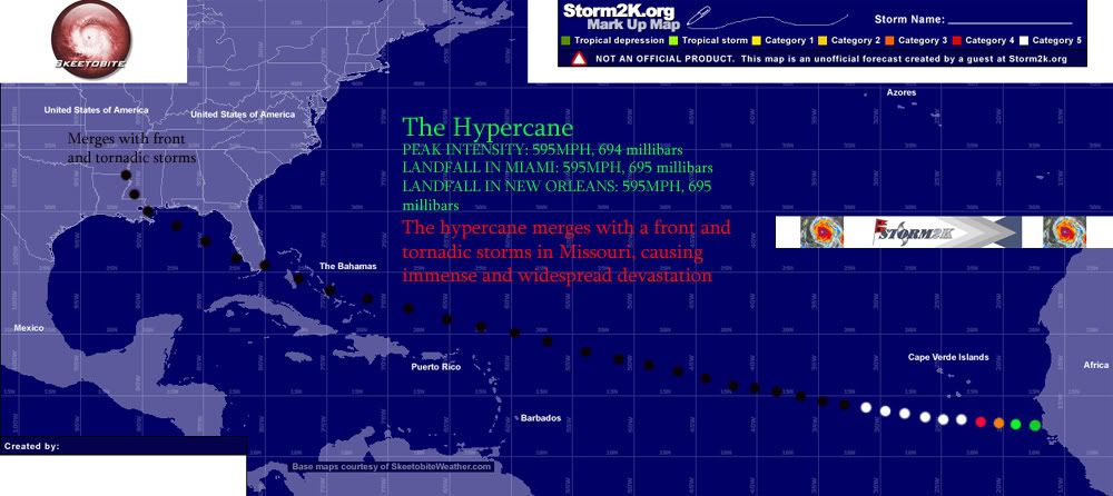
The hypercane hits both Miami and New Orleans with 595MPH winds. The storm moves inland after hitting New Orleans and merges with a front and tornadic storms associated with an ULL. This causes immense devastation in much of the central U.S. in certain parts.
Thankfully, this won't happen anywhere near now, if at all.
0 likes
-
SouthFloridawx

- S2K Supporter
- Posts: 8346
- Age: 47
- Joined: Tue Jul 26, 2005 1:16 am
- Location: Sarasota, FL
- Contact:
Who is online
Users browsing this forum: Google Adsense [Bot], hurricanes1234, Zonacane and 99 guests