Possible Big Warmup for Great Lakes/East Next Week

Winter Weather Discussion

Moderator: S2k Moderators

Forum rules

The posts in this forum are NOT official forecast and should not be used as such. They are just the opinion of the poster and may or may not be backed by sound meteorological data. They are NOT endorsed by any professional institution or STORM2K.

Help Support Storm2K
Message
Author
donsutherland1
S2K Analyst
S2K Analyst
Posts: 2718
Joined: Mon Sep 15, 2003 8:49 pm
Location: New York

Possible Big Warmup for Great Lakes/East Next Week

#1 Postby donsutherland1 » Fri Mar 03, 2006 11:37 am

In my 3/1-15 discussion, I noted that after the first week of March (particularly, the 3/10-15 timeframe), readings could surpass 60° on at least one day in Washington, DC and Richmond and perhaps 50° in Detroit. Now, based on the latest guidance, an even more impressive bout of warmth that should affect the Plains should roll eastward. Based on the latest data, that warmth should crest in the 3/9-13 period.

Right now, I’m thinking that the highest temperature during the 3/8-15 period will likely reach at least:

Boston: 55° or above
Detroit: 60° or above
New York City: 65° or above
Philadelphia: 65° or above
Washington, DC: 68° or above

Moreover, it would not surprise me if the temperature reached 70° in at least Washington, DC and perhaps Philadelphia and even New York City. 60° or above should not be ruled out for Boston.

Given the possible magnitude of warmth, a closer look is in order:

Major Teleconnection Indices:
If one examines the ensemble forecasts for the NAO and PNA, one finds strong agreement that the NAO will be in the 0.000 to +0.999 range and the PNA in the 0.000 to -2.000 range during the 3/10-15 timeframe.

In general, an NAO > 0 is a milder signal for both the Great Lakes region and East Coast. Early on, as the NAO becomes modestly positive, a PNA+ can thwart the warmup. A PNA- can exacerbate it, particularly in the Great Lakes and Mid-Atlantic regions As the NAO reaches +2.000, the PNA’s influence diminishes.

Mean temperature data for select cities for the 3/5-15 period follows:

Boston: (PNA+/PNA-)
NAO: 0 to -0.999: 34.4°/36.4°
NAO: 0 to +0.999: 35.5°/38.2°
NAO: +1 to +1.999: 36.3°/38.1°

Detroit: (PNA+/PNA-)
NAO: 0 to -0.999: 32.1°/33.1°
NAO: 0 to +0.999: 32.8°/37.7°
NAO: +1 to +1.999: 36.7°/36.3°

New York City: (PNA+/PNA-)
NAO: 0 to -0.999: 38.2°/40.5°
NAO: 0 to +0.999: 39.5°/43.1°
NAO: +1 to +1.999: 40.6°/42.7°

Philadelphia: (PNA+/PNA-)
NAO: 0 to -0.999: 38.6°/41.2°
NAO: 0 to +0.999: 39.2°/44.1°
NAO: +1 to +1.999: 42.0°/44.0°

Washington, DC (DCA): (PNA+/PNA-)
NAO: 0 to -0.999: 42.8°/46.2°
NAO: 0 to +0.999: 43.2°/49.3°
NAO: +1 to +1.999: 46.9°/47.9°

In general, as the NAO rises, one also sees an increased frequency of days in which the high temperature reaches or exceeds 50° and 60°. Data for the above cities follows:

Boston: Percentage of days 50° or above/60° or above
NAO: 0 to -0.999: 15%/2%
NAO: 0 to +0.999: 26%/14%
NAO: +1 to +1.999: 28%/12%

Detroit: Percentage of days 50° or above/60° or above
NAO: 0 to -0.999: 16%/5%
NAO: 0 to +0.999: 30%/16%
NAO: +1 to +1.999: 36%/18%

New York City: Percentage of days 50° or above/60° or above
NAO: 0 to -0.999: 33%/9%
NAO: 0 to +0.999: 43%/21%
NAO: +1 to +1.999: 50%/20%

Philadelphia: Percentage of days 50° or above/60° or above
NAO: 0 to -0.999: 41%/12%
NAO: 0 to +0.999: 49%/27%
NAO: +1 to +1.999: 59%/26%

Washington, DC (DCA): Percentage of days 50° or above/60° or above
NAO: 0 to -0.999: 58%/30%
NAO: 0 to +0.999: 65%/42%
NAO: +1 to +1.999: 73%/48%

Given the ensemble forecast for the NAO and PNA, select data (mean temperature and percentage of days 50° or above/60° or above) during the 3/5-15 period follows for the above cities:

Boston:
Mean Temperature: 39.7°
% of Days with Highs of 50° or above: 34%
% of Days with Highs of 60° or above: 20%

Detroit:
Mean Temperature: 36.9°
% of Days with Highs of 50° or above: 23%
% of Days with Highs of 60° or above: 23%

New York City:
Mean Temperature: 44.0°
% of Days with Highs of 50° or above: 49%
% of Days with Highs of 60° or above: 29%

Philadelphia:
Mean Temperature: 44.7°
% of Days with Highs of 50° or above: 57%
% of Days with Highs of 60° or above: 31%

Washington, DC:
Mean Temperature: 48.7°
% of Days with Highs of 50° or above: 69%
% of Days with Highs of 60° or above: 49%

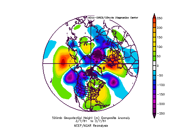
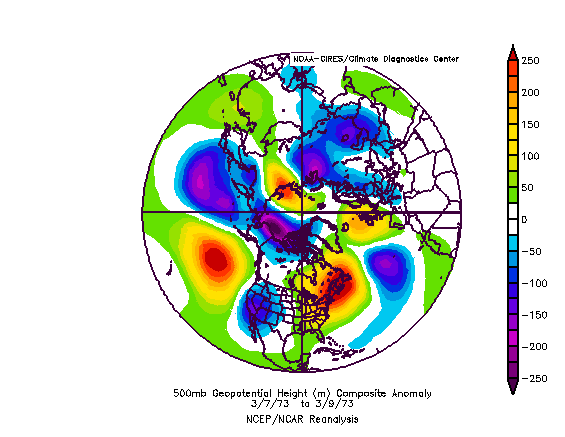
500 mb Height Anomalies:

Analog outbreaks of warmth based on forecast 500 mb anomalies and the major teleconnection data above show some similarities with those that occurred in March 1961, March 1973, and March 1990.

NCEP Ensemble Mean 500 mb Height Anomalies (3/11 0z):
Image

Composite 500 mb Height Anomalies for Select Outbreaks of Warmth (3/5-15 period):
Image

March 7, 1961:
Image

March 7-9, 1973:
Image

March 11-13, 1990:
Image

Select data for those outbreaks of warmth follow:
• All 3 cases saw readings reach 60° or above on one or more days in Detroit, New York City, Philadelphia, and Washington, DC +/- 3 days from the period assessed (i.e., 3/7/1961, 3/7-9/1973, and 3/11-13/1990).
• Boston saw readings reach 60° or above on one or more days +/- 3 days from the period assessed in two cases.
• Washington, DC reached 70° or above on one or more days two cases +/- days from the period assessed.
0 likes   

User avatar
terstorm1012
S2K Supporter
S2K Supporter
Posts: 1314
Age: 43
Joined: Fri Sep 10, 2004 5:36 pm
Location: Millersburg, PA

#2 Postby terstorm1012 » Fri Mar 03, 2006 1:03 pm

hot time, summer in the city! w00t! Here comes spring! :ggreen: :bday:
0 likes   

User avatar
Stephanie
S2K Supporter
S2K Supporter
Posts: 23843
Age: 63
Joined: Thu Feb 06, 2003 9:53 am
Location: Glassboro, NJ

#3 Postby Stephanie » Fri Mar 03, 2006 1:14 pm

terstorm1012 wrote:hot time, summer in the city! w00t! Here comes spring! :ggreen: :bday:


DITTO!! :D
0 likes   

User avatar
Hybridstorm_November2001
S2K Supporter
S2K Supporter
Posts: 2811
Joined: Sat Aug 21, 2004 2:50 pm
Location: SW New Brunswick, Canada
Contact:

#4 Postby Hybridstorm_November2001 » Fri Mar 03, 2006 4:58 pm

I did say a week or two of real cold Max (it was over three though), then back to the warmth. There just isn't enough really cold air in the Western Hemisphere to tap.
0 likes   

donsutherland1
S2K Analyst
S2K Analyst
Posts: 2718
Joined: Mon Sep 15, 2003 8:49 pm
Location: New York

#5 Postby donsutherland1 » Sat Mar 04, 2006 9:27 am

Morning thoughts...

1) The warmup continues to look real. MEX numbers (3/4 0z) are quite impressive. Highest temperature forecast for the 3/10-11 period on the MEX:

Boston: 53° (vs. 40° on the 3/3 12z version)
Detroit: 58° (vs. 56° on the 3/3 12z version)
New York City: 60° (vs. 51° on the 3/3 12z version)
Philadelphia: 64° (vs. 59° on the 3/3 12z version)
Richmond: 73° (vs. 71° on the 3/3 12z version)
Washington, DC (DCA): 68° (vs. 69° on the 3/3 12z version)

It should be noted that the MEX gives greater weight to climatology in the extended range and that makes these numbers even more remarkable than they might otherwise appear.

All said, I retain good confidence in my thinking in the following highest temperatures during the upcoming warm spell:

Boston: 55° or above
Detroit: 60° or above
New York City: 65° or above
Philadelphia: 65° or above
Washington, DC: 68° or above

70° or above at Washington, DC and possibly Philadelphia and New York City wouldn't surprise me.

2) Consistent with past history in which just over 70% of moderate blocks similar to the current one and which developed in a similar timeframe were followed by a new block within 10 days or less after they had broken, there are some hints in the ensemble mean and among some ensemble members that a new block could be developing near or just after mid-month.
0 likes   

User avatar
Stephanie
S2K Supporter
S2K Supporter
Posts: 23843
Age: 63
Joined: Thu Feb 06, 2003 9:53 am
Location: Glassboro, NJ

#6 Postby Stephanie » Sat Mar 04, 2006 10:11 am

Looking forward to it.

So, in essense, this block and the next one are pretty much signifying the end to winter and a change to spring?
0 likes   

User avatar
Hybridstorm_November2001
S2K Supporter
S2K Supporter
Posts: 2811
Joined: Sat Aug 21, 2004 2:50 pm
Location: SW New Brunswick, Canada
Contact:

#7 Postby Hybridstorm_November2001 » Sat Mar 04, 2006 12:29 pm

So it would seem.
0 likes   

donsutherland1
S2K Analyst
S2K Analyst
Posts: 2718
Joined: Mon Sep 15, 2003 8:49 pm
Location: New York

#8 Postby donsutherland1 » Sat Mar 04, 2006 1:38 pm

I haven't seen the 3/4 12z MEX figures just yet, but the 3/4 12z GFS 2m forecast is still bullish on the warmth. Highest figures include:

Boston: 57°
Detroit: 56°
New York City: 63°
Philadelphia: 67°
Richmond: 77°
Washington, DC (DCA): 76°

Given the continuing strong support in the GFS ensembles and the historic experience with patterns similar to the forecast one for later next week, I have above average confidence in the coming warmup and its magnitude.
0 likes   

donsutherland1
S2K Analyst
S2K Analyst
Posts: 2718
Joined: Mon Sep 15, 2003 8:49 pm
Location: New York

#9 Postby donsutherland1 » Sat Mar 04, 2006 2:47 pm

The MEX figures:

Boston:
3/3 12z run: 40°
3/4 0z run: 53°
3/4 12z run: 57°

Detroit:
3/3 12z run: 56°
3/4 0z run: 58°
3/4 12z run: 60°

New York City:
3/3 12z run: 51°
3/4 0z run: 60°
3/4 12z run: 61°

Philadelphia:
3/3 12z run: 59°
3/4 0z run: 64°
3/4 12z run: 61°

Richmond:
3/3 12z run: 71°
3/4 0z run: 73°
3/4 12z run: 77°

Washington, DC (DCA):
3/3 12z run: 69°
3/4 0z run: 68°
3/4 12z run: 70°
0 likes   

User avatar
coriolis
Retired Staff
Retired Staff
Posts: 8314
Joined: Wed Feb 05, 2003 10:58 pm
Location: Muncy, PA

#10 Postby coriolis » Sat Mar 04, 2006 8:32 pm

I'll take the warmth. But could we have some rain first to get rid of all this %#@$%&# SALT that they put everywhere for that last little nuisance storm.
0 likes   
This space for rent.

donsutherland1
S2K Analyst
S2K Analyst
Posts: 2718
Joined: Mon Sep 15, 2003 8:49 pm
Location: New York

#11 Postby donsutherland1 » Sun Mar 05, 2006 1:04 pm

Coriolis,

Hopefully, the warm front will bring at least a little rain. I don't think it will be enough this time around.
0 likes   

donsutherland1
S2K Analyst
S2K Analyst
Posts: 2718
Joined: Mon Sep 15, 2003 8:49 pm
Location: New York

#12 Postby donsutherland1 » Sun Mar 05, 2006 1:04 pm

Latest MEX figures:

Boston:
3/3 12z run: 40°
3/4 0z run: 53°
3/4 12z run: 57°
3/5 0z run: 57°
3/5 12z run: 60°

Detroit:
3/3 12z run: 56°
3/4 0z run: 58°
3/4 12z run: 60°
3/5 0z run: 56°
3/5 12z run: 59°

New York City:
3/3 12z run: 51°
3/4 0z run: 60°
3/4 12z run: 61°
3/5 0z run: 65°
3/5 12z run: 66°

Philadelphia:
3/3 12z run: 59°
3/4 0z run: 64°
3/4 12z run: 61°
3/5 0z run: 65°
3/5 12z run: 68°

Richmond:
3/3 12z run: 71°
3/4 0z run: 73°
3/4 12z run: 77°
3/5 0z run: 72°
3/5 12z run: 73°

Washington, DC (DCA):
3/3 12z run: 69°
3/4 0z run: 68°
3/4 12z run: 70°
3/5 0z run: 71°
3/5 12z run: 72°

Again, it should be noted that the MEX gives greater weight to climatology in the longer-term. The 3/5 12z GFS forecasts even warmer highs for the height of the warmth. Its highest 2m temperatures for the above cities are:

Boston: 62°
Detroit: 62°
New York City: 70°
Philadelphia: 72°
Richmond: 78°
Washington, DC (DCA): 73°
0 likes   

User avatar
Stephanie
S2K Supporter
S2K Supporter
Posts: 23843
Age: 63
Joined: Thu Feb 06, 2003 9:53 am
Location: Glassboro, NJ

#13 Postby Stephanie » Sun Mar 05, 2006 9:07 pm

The extended forecast says 70 degrees on Saturday! :D

There are SO MANY robin out now. They are around during the winter but when spring is near, they are everywhere like now! :D
0 likes   

User avatar
ohiostorm
Category 5
Category 5
Posts: 1582
Age: 40
Joined: Sat Oct 12, 2002 2:51 pm
Location: Orlando, FL
Contact:

#14 Postby ohiostorm » Mon Mar 06, 2006 10:57 am

The mild temps start showing up here by midweek. Mid to upper 60's as of now with rain showers.
0 likes   

donsutherland1
S2K Analyst
S2K Analyst
Posts: 2718
Joined: Mon Sep 15, 2003 8:49 pm
Location: New York

#15 Postby donsutherland1 » Mon Mar 06, 2006 12:46 pm

Latest MEX figures:

Boston:
3/3 12z run: 40°
3/4 0z run: 53°
3/4 12z run: 57°
3/5 0z run: 57°
3/5 12z run: 60°
3/6 0z run: 55°
3/6 12z run: 59°

Detroit:
3/3 12z run: 56°
3/4 0z run: 58°
3/4 12z run: 60°
3/5 0z run: 56°
3/5 12z run: 59°
3/6 0z run: 61°
3/6 12z run: 59°

New York City:
3/3 12z run: 51°
3/4 0z run: 60°
3/4 12z run: 61°
3/5 0z run: 65°
3/5 12z run: 66°
3/6 0z run: 60°
3/6 12z run: 62°

Philadelphia:
3/3 12z run: 59°
3/4 0z run: 64°
3/4 12z run: 61°
3/5 0z run: 65°
3/5 12z run: 68°
3/6 0z run: 65°
3/6 12z run: 65°

Richmond:
3/3 12z run: 71°
3/4 0z run: 73°
3/4 12z run: 77°
3/5 0z run: 72°
3/5 12z run: 73°
3/6 0z run: 72°
3/6 12z run: 71°

Washington, DC (DCA):
3/3 12z run: 69°
3/4 0z run: 68°
3/4 12z run: 70°
3/5 0z run: 71°
3/5 12z run: 72°
3/6 0z run: 71°
3/6 12z run: 69°
0 likes   

mdlemin
Tropical Low
Tropical Low
Posts: 30
Joined: Tue Aug 31, 2004 5:19 pm
Location: Monroeville, PA
Contact:

#16 Postby mdlemin » Mon Mar 06, 2006 4:27 pm

I hope it is nice here in Pittburgh by March 22 as I have a very special event going on that day. If anyone has an idea what will happen on that day, I would appreciate the info. Thank you ahead of time.
0 likes   

User avatar
WindRunner
Category 5
Category 5
Posts: 5806
Age: 34
Joined: Fri Jul 29, 2005 8:07 pm
Location: Warrenton, VA, but Albany, NY for school
Contact:

#17 Postby WindRunner » Mon Mar 06, 2006 8:28 pm

I know the NWS in Sterling is going with 69 on Friday, 75 on Saturday, 68 on Sunday, and 74 on Monday, and hinting at continuing into the workweek. That would be a nice change, but does it seem reasonable? For DCA they call for 72-74-68-72 for Friday through Sunday. Do you think the models are calling the numbers a little low, or is the NWS just getting ahead of themselves?
0 likes   

Jim Hughes
Category 3
Category 3
Posts: 825
Joined: Sun Jul 24, 2005 1:52 pm
Location: Martinsburg West Virginia

#18 Postby Jim Hughes » Tue Mar 07, 2006 7:58 am

WindRunner wrote:I know the NWS in Sterling is going with 69 on Friday, 75 on Saturday, 68 on Sunday, and 74 on Monday, and hinting at continuing into the workweek. That would be a nice change, but does it seem reasonable? For DCA they call for 72-74-68-72 for Friday through Sunday. Do you think the models are calling the numbers a little low, or is the NWS just getting ahead of themselves?


I think everybody is getting ahead of themselves. I'll grant you that the MJO just hooked into a lower amplitude and this makes things a little fuzzy but I feel strongly that the temperatures for the Northeast, as a whole , are not going to be as warm as what the models are forecasting.

Things should start changing by Sunday into Monday.


Jim
0 likes   

donsutherland1
S2K Analyst
S2K Analyst
Posts: 2718
Joined: Mon Sep 15, 2003 8:49 pm
Location: New York

#19 Postby donsutherland1 » Tue Mar 07, 2006 1:08 pm

Latest MEX figures:

Boston:
3/3 12z run: 40°
3/4 0z run: 53°
3/4 12z run: 57°
3/5 0z run: 57°
3/5 12z run: 60°
3/6 0z run: 55°
3/6 12z run: 59°
3/7 0z run: 61°
3/7 12z run: 58°

Detroit:
3/3 12z run: 56°
3/4 0z run: 58°
3/4 12z run: 60°
3/5 0z run: 56°
3/5 12z run: 59°
3/6 0z run: 61°
3/6 12z run: 59°
3/7 0z run: 58°
3/7 12z run: 57°

New York City:
3/3 12z run: 51°
3/4 0z run: 60°
3/4 12z run: 61°
3/5 0z run: 65°
3/5 12z run: 66°
3/6 0z run: 60°
3/6 12z run: 62°
3/7 0z run: 62°
3/7 12z run: 64°

Philadelphia:
3/3 12z run: 59°
3/4 0z run: 64°
3/4 12z run: 61°
3/5 0z run: 65°
3/5 12z run: 68°
3/6 0z run: 65°
3/6 12z run: 65°
3/7 0z run: 65°
3/7 12z run: 66°

Richmond:
3/3 12z run: 71°
3/4 0z run: 73°
3/4 12z run: 77°
3/5 0z run: 72°
3/5 12z run: 73°
3/6 0z run: 72°
3/6 12z run: 71°
3/7 0z run: 74°
3/7 12z run: 77°

Washington, DC (DCA):
3/3 12z run: 69°
3/4 0z run: 68°
3/4 12z run: 70°
3/5 0z run: 71°
3/5 12z run: 72°
3/6 0z run: 71°
3/6 12z run: 69°
3/7 0z run: 70°
3/7 12z run: 70°

It is increasingly looking like a rather dramatic turn to colder could occur in the 3/14-16 period as blocking redevelops. This could lead to at least a renewed opportunity for some additional accumulations of snow in the Great Lakes region/Mid-Atlantic states/and New England the calendar continues to advance toward and beyond the Spring Equinox. A NAO-/PNA- setup could be especially conducive to snowfall opportunities given past situations (though changeover cases might be more likely for the northern Mid-Atlantic and southward than all snow ones).
0 likes   

Jim Hughes
Category 3
Category 3
Posts: 825
Joined: Sun Jul 24, 2005 1:52 pm
Location: Martinsburg West Virginia

#20 Postby Jim Hughes » Tue Mar 07, 2006 1:47 pm

donsutherland1 wrote:
It is increasingly looking like a rather dramatic turn to colder could occur in the 3/14-16 period as blocking redevelops. This could lead to at least a renewed opportunity for some additional accumulations of snow in the Great Lakes region/Mid-Atlantic states/and New England the calendar continues to advance toward and beyond the Spring Equinox. A NAO-/PNA- setup could be especially conducive to snowfall opportunities given past situations (though changeover cases might be more likely for the northern Mid-Atlantic and southward than all snow ones).


Ah.... but I might be running out of time Don. I guess I can hope for a photo finish on the 16th. :)


Jim
0 likes   


Return to “Winter Weather”

Who is online

Users browsing this forum: No registered users and 8 guests