This a rather unusual situation with consideration to where this appears to be developing.. The Eastern side of the Atlantic is not generally conducive to Tropical Storms, either North or South of the equator and certainly not something that we might experience this far South.. But,, changes are taking place all across the Planet as far as our weather is being represented. in our interpretations,,.
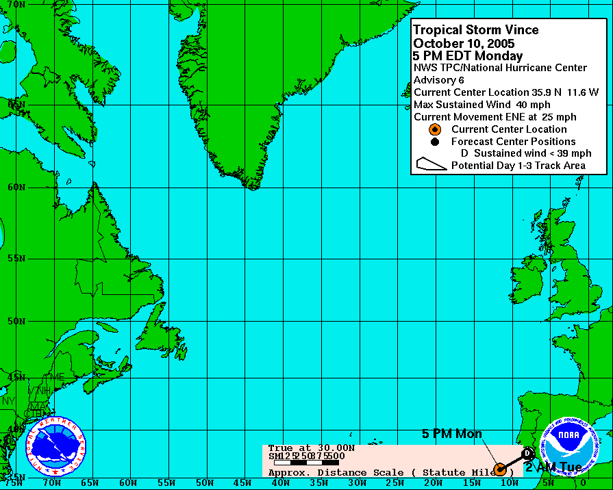
Take a Look at where Hurricane Vince Started last year and how quickly the NHC/TPC jumped on that one...
http://www.nhc.noaa.gov/archive/2005/gr ... L2305W.GIF
Click on the Link in the previous post...
It sure looks like a Tropical Cyclone to this observer...
I am taking into consideration that 2 Southern Seasons ago there was a significant Hurricane that formed and came onshore in South America and was poo pooed off by many that thought the development was not possible, until the NHC brought Goes Floater over the system and it sure was a cat#3 at its peak... JMHO,,, most say it was a weak cat#1 but scats and shipping reports say different, just the Sat View tells a great visual story.. Funny in a morbid sence, that the damage reports were played down and almost nonexistant in the aftermath after landfall...
http://cimss.ssec.wisc.edu/tropic/brazi ... 228ls1.gif
You and all who view this thought can write off a Southern Atlantic Season as it developes in the years to come, but the reality is quite apparent in the statistics.. We are seeing systems that in other parts of the world would be Named and Identified as Tropical Cyclones..
The System of identification needs to be standardized across the Planet,, to include the South Atlantic Ocean.....
This is amazing a tropical storm appears to have formed in
Moderator: S2k Moderators
Forum rules

The posts in this forum are NOT official forecasts and should not be used as such. They are just the opinion of the poster and may or may not be backed by sound meteorological data. They are NOT endorsed by any professional institution or STORM2K. For official information, please refer to products from the National Hurricane Center and National Weather Service.
-
Mezocyclone
- Tropical Storm

- Posts: 118
- Joined: Mon Jul 21, 2003 9:16 am
- Location: Largo, Florida... Pinellas County
- Contact:
-
Matt-hurricanewatcher
-
Matt-hurricanewatcher
-
P.K.

- Professional-Met

- Posts: 5149
- Joined: Thu Sep 23, 2004 5:57 pm
- Location: Watford, England
- Contact:
FQNT50 LFPW 210931
A
SECURITE
WEATHER BULLETIN FOR METAREA 2, METEO-FRANCE,
TOULOUSE, TUESDAY 21 FEBRUARY 2006 AT 09 UTC.
- WIND SPEED IN BEAUFORT SCALE - SEA : TOTAL SIGNIFICANT -
- PLEASE BE AWARE, WIND GUSTS CAN BE A FURTHER 40 PERCENT STRONGER
THAN THE AVERAGES GIVEN HERE, AND MAXIMUM WAVES MAY BE UP TO TWICE
THE SIGNIFICANT HEIGHT.
PART 2 : GENERAL SYNOPSIS, TUESDAY 21 AT 00 UTC
ITCZ ALONG 6N9W 2N21W 1N26W 1N50W.
PART 3 : AREA FORECASTS TO WEDNESDAY 22 AT 12 UTC
POINTE NOIRE :
MAINLY SOUTHEAST 2 TO 4, LOCALLY EASTERLY IN FAR WEST. SLIGHT,
LOCALLY MODERATE IN WEST. THUNDERSQUALLS WITH SEVERE GUSTS.
This is the best I can do for a visible image in that area, Meteosat-8 is having problems at the moment.
0 likes

-
SouthFloridawx

- S2K Supporter

- Posts: 8346
- Age: 47
- Joined: Tue Jul 26, 2005 1:16 am
- Location: Sarasota, FL
- Contact:
it looks to be sheared....
but, on the other hand that low pressure system over southern africa looks pretty impressive...
Bet they are getting some pretty nasty weather there now.
https://afweather.afwa.af.mil/images/sa ... 19IR_L.GIF
but, on the other hand that low pressure system over southern africa looks pretty impressive...
Bet they are getting some pretty nasty weather there now.
https://afweather.afwa.af.mil/images/sa ... 19IR_L.GIF
0 likes
-
SouthFloridawx
- S2K Supporter
- Posts: 8346
- Age: 47
- Joined: Tue Jul 26, 2005 1:16 am
- Location: Sarasota, FL
- Contact:

-
SouthFloridawx
- S2K Supporter
- Posts: 8346
- Age: 47
- Joined: Tue Jul 26, 2005 1:16 am
- Location: Sarasota, FL
- Contact:

-
JonathanBelles
- Professional-Met
- Posts: 11430
- Age: 35
- Joined: Sat Dec 24, 2005 9:00 pm
- Location: School: Florida State University (Tallahassee, FL) Home: St. Petersburg, Florida
- Contact:
-
senorpepr

- Military Met/Moderator

- Posts: 12542
- Age: 43
- Joined: Fri Aug 22, 2003 9:22 pm
- Location: Mackenbach, Germany
- Contact:
fact789 wrote:what is the earliest a TS has formed in the south atlantic?
Keep in mind that this is the Southern Hemisphere. This isn't "early". A tropical cyclone developing in the Southern Hemisphere in late February is like a tropical cyclone developing in the Northern Hemisphere in late August.
0 likes
-
Derek Ortt
-
brunota2003

- S2K Supporter
- Posts: 9476
- Age: 35
- Joined: Sat Jul 30, 2005 9:56 pm
- Location: Stanton, KY...formerly Havelock, NC
- Contact:
ok...where is this so called system on the quickscat pics posted here??? I see a lot of rain contaminated winds...but no closed circulation...it does look like some heavy convection, but you see that in alot of waves...I'm not raising my "OMG We Are All Going To Die" banners until either I see something noteworthy or the NHC says something about the "system" just my $0.02
0 likes
-
senorpepr
- Military Met/Moderator
- Posts: 12542
- Age: 43
- Joined: Fri Aug 22, 2003 9:22 pm
- Location: Mackenbach, Germany
- Contact:
brunota2003 wrote:ok...where is this so called system on the quickscat pics posted here??? I see a lot of rain contaminated winds...but no closed circulation...it does look like some heavy convection, but you see that in alot of waves...I'm not raising my "OMG We Are All Going To Die" banners until either I see something noteworthy or the NHC says something about the "system" just my $0.02
That post just earned you one gold star.

0 likes
-
SouthFloridawx
- S2K Supporter
- Posts: 8346
- Age: 47
- Joined: Tue Jul 26, 2005 1:16 am
- Location: Sarasota, FL
- Contact:

-
Matt-hurricanewatcher
-
wxmann_91

- Category 5

- Posts: 8013
- Age: 34
- Joined: Fri Jul 15, 2005 2:49 pm
- Location: Southern California
- Contact:
senorpepr wrote:brunota2003 wrote:ok...where is this so called system on the quickscat pics posted here??? I see a lot of rain contaminated winds...but no closed circulation...it does look like some heavy convection, but you see that in alot of waves...I'm not raising my "OMG We Are All Going To Die" banners until either I see something noteworthy or the NHC says something about the "system" just my $0.02
That post just earned you one gold star.

0 likes
-
Matt-hurricanewatcher
There is a reason why no systems form normally down there. In that is reason is there is a super central south Atlantic high that has one heck of alot of sinking air. In which this run into it. I still believe it had a some what closed LLC with 35 knot winds based on the quickscat. Irene,charley,emily all had there times when the quickscats did not pick up the LLC in both charley,emily where hurricanes.
I would watch with interest the system about ready to come off at 20 south...At least this is something to do. I enjoy watching these kind of systems.
I will believe as I will why because I enjoy tropical weather...In thats half the fun.
I would watch with interest the system about ready to come off at 20 south...At least this is something to do. I enjoy watching these kind of systems.
I will believe as I will why because I enjoy tropical weather...In thats half the fun.
0 likes
Who is online
Users browsing this forum: No registered users and 152 guests