Rita Downgraded?

This is the general tropical discussion area. Anyone can take their shot at predicting a storms path.

Moderator: S2k Moderators

Forum rules

The posts in this forum are NOT official forecasts and should not be used as such. They are just the opinion of the poster and may or may not be backed by sound meteorological data. They are NOT endorsed by any professional institution or STORM2K. For official information, please refer to products from the National Hurricane Center and National Weather Service.

Help Support Storm2K
Message
Author
User avatar
docjoe
S2K Supporter
S2K Supporter
Posts: 262
Joined: Thu Sep 09, 2004 10:42 pm
Location: SE Alabama..formerly the land of ivan and dennis

#61 Postby docjoe » Wed Feb 15, 2006 5:33 pm

dhweather wrote:
wxman57 wrote:
dhweather wrote:Also, this goes back to the argument that the NHC needs to have a seperate SURGE WARNING for hurricanes.

A storm coming down from a 5 to a 2/3 will still have the surge of a 4/5 at landfall in the GOM.

A storm coming up to a 2 from a TS or 1 will have the surge of a TS or 1, with small areas of 2 surge.


I disagree with the logic above. As per my previous post, storm surge is more a function of the areal coverage of a hurricane's higher wind speeds (74+ mph, for example) than a function of the peak wind that may cover only a limited number of square miles (based on SS scale). Here's an example.

Let's say we have a hurricane with hurricane-force winds extending out 100 miles in all quadrants. That's an areal coverage of 31, 400 square miles. Now let's assume it's a Cat 4 with 140 mph winds only in the NE Quadrant at a distance of about 20 miles from the center. That's a max areal coverage of Cat 4 winds of probably 200 square miles at the most (that may be generous). Now, drop the wind speed in that 200 sq. mile area from 140 to 120 mph and you're not going to significantly affect the storm surge that extends out to 100 miles or more from the center. Such a reduction of ONLY the peak wind speed (all else being equal) may have an insignificant effect on the storm surge of a landfalling hurricane.

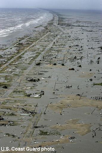
That's basically what happened last season with Katrina and Rita. The 74+ mph wind field remained constant but the small area of peak winds northeast of the core weakened a few categories. Therefore, Katrina and Rita produced a storm surge that was greater than what the SS scale would indicate for an average-sized Category 2 or 3 hurricane.

But you can't say that Rita or Katrina produced a Cat 4 or Cat 5 surge, as there's no such thing. Katrina was a Cat 3, so it produced a surge reprensentative of what a much larger-than-average Category 3 hurricane would normally produce. It's just that the SS scale doesn't consider such abnormalities.

So, in the same line of thinking, you can't arbitrarily state that a Cat 2 which weakens to a strong TS at landfall would produce a "Cat 1 surge" or that a Cat 5 that weakens to a Cat 2/3 will have a "Cat 4/5 surge". That's simply not true under all circumstances. It MAY be true that if only the peak wind is reduced (not the areal coverage of 74+ mph winds) then a Cat 5 that weakens to a Cat 2/3 at landfall would produce a storm surge that would be much larger than that expected from a typical Cat 2/3.

On the other hand, if Katrina had not only weakened from a Cat 5 to a Cat 3, but had its hurricane-force and greater wind field areal coverage decreased by half or more, then Katrina would not have produced a storm surge nearly as extensive as it did. A further reduction of the area of Katrina's higher wind radii prior to landfall may have resulted in a storm surge more typically associated with a landfalling Category 3 hurricane.


I still have to look at what history tells me:

Here's a list of storms that were cat 5's in the Gulf of Mexico, and their surge at landfall:

2005: Rita "At least 15 feet" (Cameron Parish, LA)
2005: Katrina 30+ Feet (Bay St. Louis, MS)
2004: Ivan 12 feet (Navarre Beach, FL)
1969: Camille 27 Feet (Bay St. Louis, MS)
1967: Beulah "At least 18 feet" (30MI S Corpus Christi)
1961: Carla 18.5 feet (Port Lavaca, TX)

In the last 45 years, hurricanes that have been category 5 strength
in the Gulf of Mexico, all but Ivan produced category 5 surge.


There are many things that contribute to the storm surge, however, I
believe that once a hurricane reaches category 5 strength in the
GOM, the overwhelming odds are that it will produce category 5
storm surge at landfall, regardless of its SS intensity.

The SS scale has a category 5 hurricane storm surge listed as:

Storm surge generally greater than 18 ft above normal.


according to local reports Mackey Cove in upper Escambia Bay had a measured surge of 18 feet. There were also local reports in several places of surge greater than 12 feet.

docjoe
0 likes   

Derek Ortt

#62 Postby Derek Ortt » Wed Feb 15, 2006 6:56 pm

again


there is no such thing as category 5 surge. That SS is an unofficial approximation. People need to stop clinging to that number as a fact, when nobody in the field uses it that way
0 likes   

User avatar
wxman57
Moderator-Pro Met
Moderator-Pro Met
Posts: 23022
Age: 68
Joined: Sat Jun 21, 2003 8:06 pm
Location: Houston, TX (southwest)

#63 Postby wxman57 » Wed Feb 15, 2006 7:06 pm

dhweather wrote:
I still have to look at what history tells me:

Here's a list of storms that were cat 5's in the Gulf of Mexico, and their surge at landfall:

2005: Rita "At least 15 feet" (Cameron Parish, LA)
2005: Katrina 30+ Feet (Bay St. Louis, MS)
2004: Ivan 12 feet (Navarre Beach, FL)
1969: Camille 27 Feet (Bay St. Louis, MS)
1967: Beulah "At least 18 feet" (30MI S Corpus Christi)
1961: Carla 18.5 feet (Port Lavaca, TX)

In the last 45 years, hurricanes that have been category 5 strength
in the Gulf of Mexico, all but Ivan produced category 5 surge.


There are many things that contribute to the storm surge, however, I
believe that once a hurricane reaches category 5 strength in the
GOM, the overwhelming odds are that it will produce category 5
storm surge at landfall, regardless of its SS intensity.

The SS scale has a category 5 hurricane storm surge listed as:

Storm surge generally greater than 18 ft above normal.


I think you're still missing the point. A hurricane having a tiny area of Cat 5 winds but a huge area of, say, 60-110 mph winds, would not necessarily produce any higher a storm surge than a hurricane with max winds in the Cat 2 range but the exact same area of 60-110 mph winds. It's not the PEAK wind in a small area that is responsible for the surge extending out 50-100 miles from the center. So the SS rating may almost be irrelevant as far as potential storm surge is concerned for some types of hurricanes.

And you also have to consider that storm surge is highly dependent upon where the center crosses the coast. Just so happens that one of the coastal areas with the highest surge multiplier (1.9) is the western MS coast, exactly where Katrina and Camille moved ashore. These same two hurricanes moving ashore toward the FL Panhandle may have produced a surge only half of what was observed. If Ivan had moved ashore farther west toward the mouth of the Pearl River, then it could have produced a surge of 20-25 feet, similar to Camille.

Carla was a HUGE hurricane at landfall, one of the largest and most powerful hurricanes to ever strike the U.S., so it should have produced a large surge, even on the mid TX coast where the surge multiplier was much lower than the MS coast.

Rita also had an abnormally large area of hurricane-force winds at landfall, probably in the top 10% of all hurricanes. So, again, it doesn't matter what Rita's peak winds near the core were the day before, it's the size of the higher wind field which produces the surge.

The SS scale should not be used for surge projection, as it doesn't consider many of the variables involved.
0 likes   

User avatar
dhweather
S2K Supporter
S2K Supporter
Posts: 6199
Joined: Sat Aug 14, 2004 9:29 pm
Location: Heath, TX
Contact:

#64 Postby dhweather » Wed Feb 15, 2006 7:32 pm

I actually get your point. But my point, and that of many others, is that there is
no real warning system in place for surge.

We know the multiplier is high in all of the Mississippi Gulf Coast.
The NHC stuck with "dangerous storm surge" and "large battering waves",
almost until the end of Katrina. Then "localized" 27 foot surge became possible.
That "localized" area was about 30 miles across - much more than local in my opinion.

The bottom line is that the NHC, USACE and others know the high risk areas
and need to do a better job getting that information out. You know it, I know it, the average joe doesn't know it.
0 likes   

User avatar
dhweather
S2K Supporter
S2K Supporter
Posts: 6199
Joined: Sat Aug 14, 2004 9:29 pm
Location: Heath, TX
Contact:

#65 Postby dhweather » Wed Feb 15, 2006 7:33 pm

Derek Ortt wrote:again


there is no such thing as category 5 surge. That SS is an unofficial approximation. People need to stop clinging to that number as a fact, when nobody in the field uses it that way


Derek - how else can anyone convey surge then? All we have today
is the SS scale and its estimates. Your post makes the argument that
we need something seperate in place for storm surge.
0 likes   

Derek Ortt

#66 Postby Derek Ortt » Wed Feb 15, 2006 8:55 pm

surge is too complex due to the coastal topography to quantify in terms of categories.

People should have payed attention to the NHC public advisories that stated up to 28 feet in the heads of Bays (storm tide would have been closer to 30 feet). NHC was saying in their advisories that this would be worse than Camielle, by citing the 28 foot surge number
0 likes   

Scorpion

#67 Postby Scorpion » Wed Feb 15, 2006 8:59 pm

It's a good thing Katrina was a Cat 5 before landfall because it scared almost everyone into leaving. Imagine if it would have remained a large Cat 3/4. Less people would have left.
0 likes   

User avatar
Ixolib
Category 5
Category 5
Posts: 2741
Age: 68
Joined: Sun Aug 08, 2004 8:55 pm
Location: Biloxi, MS

#68 Postby Ixolib » Wed Feb 15, 2006 9:16 pm

Scorpion wrote:It's a good thing Katrina was a Cat 5 before landfall because it scared almost everyone into leaving. Imagine if it would have remained a large Cat 3/4. Less people would have left.


Good point!! Very good point... :uarrow:
0 likes   

User avatar
MGC
S2K Supporter
S2K Supporter
Posts: 5907
Joined: Sun Mar 23, 2003 9:05 pm
Location: Pass Christian MS, or what is left.

#69 Postby MGC » Wed Feb 15, 2006 9:26 pm

Yes Scorion I think you hit the nail on the head. I would have stayed had Katrina remained a Cat-3 and I'm sure a lot more people would have stayed since in recent history Hurricane Elana was a Cat-3 here on the coast. Most everyone I talked with said they had survived Camille and didn't think Katrina was going to be as bad. Really though, there should be a new system of ranking hurricanes. The SS scale don't classify the real risk of a hurricane, the water. Of all the great hurricanes, the real killers have been from surge. Just imagine if Katrina had hit 50 years ago. New Orleans didn't have much of a levee system back then, there was no satellites to track the hurricane, recon was a new invention. Tens of thousands would have died, making the Galveston Hurricane look like a walk in the park.......MGC
0 likes   

MiamiensisWx

#70 Postby MiamiensisWx » Wed Feb 15, 2006 10:04 pm

Good point, Scorpion! Talk about a blessing (and possibly a curse as well) in disguise!
0 likes   

Margie

#71 Postby Margie » Wed Feb 15, 2006 10:34 pm

hurricanetrack wrote:I also know that Josh Wurman was nearby with his DOW. I would sure like to know what those babies recorded.


Well all you have to do is pick up the phone and call. Josh is a very accessible person...and a nice guy.

He's doing a talk in Monterey on what they found with Rita.
0 likes   

Margie

#72 Postby Margie » Wed Feb 15, 2006 10:38 pm

TheEuropean wrote:The coast at Holy Beach after Rita:

Image

Total devastation from a cat2?


That damage was all due to surge, so there is no clue as to what the winds might have been at that location.

Another case of an enhanced surge from a hurricane that was more intense in deep water before moving onto the shallow continental shelf.
0 likes   

HurricaneBill
Category 5
Category 5
Posts: 3420
Joined: Sun Apr 11, 2004 5:51 pm
Location: East Longmeadow, MA, USA

#73 Postby HurricaneBill » Wed Feb 15, 2006 10:47 pm

With all this talk about intense hurricanes rapidly weakening as they near the northern Gulf coast, I was wondering if the opposite can happen.

Could a hurricane move through the Gulf as a Category 1 or 2 suddenly strengthen up to a strong Category 3 prior to landfall?
0 likes   

User avatar
Extremeweatherguy
Category 5
Category 5
Posts: 11095
Joined: Mon Oct 10, 2005 8:13 pm
Location: Florida

#74 Postby Extremeweatherguy » Wed Feb 15, 2006 11:12 pm

HurricaneBill wrote:With all this talk about intense hurricanes rapidly weakening as they near the northern Gulf coast, I was wondering if the opposite can happen.

Could a hurricane move through the Gulf as a Category 1 or 2 suddenly strengthen up to a strong Category 3 prior to landfall?
well that is what Charley did before landfall on SW Florida. It was a weak Cat. 2 in the morning, but exploded to a very strong Cat. 4 within hours.
0 likes   

User avatar
Extremeweatherguy
Category 5
Category 5
Posts: 11095
Joined: Mon Oct 10, 2005 8:13 pm
Location: Florida

#75 Postby Extremeweatherguy » Wed Feb 15, 2006 11:13 pm

Margie wrote:
TheEuropean wrote:The coast at Holy Beach after Rita:

Image

Total devastation from a cat2?


That damage was all due to surge, so there is no clue as to what the winds might have been at that location.

Another case of an enhanced surge from a hurricane that was more intense in deep water before moving onto the shallow continental shelf.
Exactly. I don't like it when people try to base wind damage estimates off of pictures that are clearly from surge damage. That picture is incredible though...shows the power of Rita's surge quite well.
0 likes   

Derek Ortt

#76 Postby Derek Ortt » Wed Feb 15, 2006 11:37 pm

Charley was not north GOM

Also, its intensification appears to have been purely QG driven. By the time it reached Orlando, it was not very tropical at all (more baroclinic).

The only way we can see a 4 hit the NGOM, IMO, is for a large storm of Wilma's size get a similar QG enhancement that Charley received
0 likes   

Javlin
Category 5
Category 5
Posts: 1621
Age: 64
Joined: Fri Jul 09, 2004 7:58 pm
Location: ms gulf coast

#77 Postby Javlin » Thu Feb 16, 2006 8:01 am

I hear what you mets are saying but what about some of the other storms that hit the coast.Elena came in as a Cat 3 but only produced 6'-8' surge at Dauphin Island.If the the surge is a by product of the size and strength of the wind field shouldn't some areas seen a larger surge but a smaller area?I am just having a problem with seeing the energy displacement of the once potential higher Cat storm dissappearing so quickly.Where did it go?The Perfect Storm generated some serious swells quickly in the N.Atlantic were they not wind generated in some manner?


Oh by the way you might have a classroom of idiots here with me at the top of the list :oops:
0 likes   

jeff
Professional-Met
Professional-Met
Posts: 831
Joined: Sun Sep 12, 2004 6:14 pm
Location: Houston, TX
Contact:

#78 Postby jeff » Thu Feb 16, 2006 8:12 am

The following is a paragraph from my post Katrina Report detailing surge effects. You can apply it to Rita as well.

On a personal note, I have been 3 times to SW LA and fully agree cat 1-2 winds were the norm. The surge was impressive however.


Katrina made landfall as a category 3 hurricane yet produced a "category 5" storm surge. Why? The Saffir Simpson scale is based on sustained wind speeds with an indirect correlation with respect to storm surge. Storm surge inundation forecast are compiled from a number of factors and each hurricane landfall is unique. The factors that control storm surge include: the size of the wind field, the intensity of the storm, the duration of the event, the angle of approach to the coast, the depth of the offshore coastal shelf, concavity of the coastline, and special conditions such as storm surge run-up into smaller bays and rivers.

Katrina’s large wind field and category 5 intensity while over the open Gulf of Mexico created a large water level bulge that arrived as a catastrophic storm surge when the hurricane made landfall. The rapid sustained wind speed weakening a few hours before landfall and reduction in Saffir Simpson category did not represent the impending storm surge effectively to the public although preparations were made for a category 5 event. The concavity of the coastal area impacted, the size of the wind field, and the built up water level bulge when Katrina was a category 5 over the open Gulf of Mexico is why Katrina produced such an extreme surge.

Education of the public should be addressed to inform persons in the inundation zones of the different factors involved in storm surge forecast and the potential failures of the Saffir Simpson scale to appropriately predict storm surge levels. Prior to a hurricane landfall, residents should base evacuation and preparation decisions on local NWS forecast of storm surge inundation using computer modeling and experience and not the general Saffir Simpson scale values assigned per category. Large rapidly weakening hurricanes are still likely to bring a large and destructive surge ashore. Additionally, residents at the heads of bays, the mouths of rivers and creeks, and small inlets can receive a substantially higher surge due to water level run-up into an increasingly smaller area. Such affects are unique to a certain coastal location and usually depend heavily on the exact track (ie. MRGO and IHNC surge effects due to track).
0 likes   

jeff
Professional-Met
Professional-Met
Posts: 831
Joined: Sun Sep 12, 2004 6:14 pm
Location: Houston, TX
Contact:

#79 Postby jeff » Thu Feb 16, 2006 8:18 am

Extremeweatherguy wrote:
Margie wrote:
TheEuropean wrote:The coast at Holy Beach after Rita:

Image

Total devastation from a cat2?


That damage was all due to surge, so there is no clue as to what the winds might have been at that location.

Another case of an enhanced surge from a hurricane that was more intense in deep water before moving onto the shallow continental shelf.
Exactly. I don't like it when people try to base wind damage estimates off of pictures that are clearly from surge damage. That picture is incredible though...shows the power of Rita's surge quite well.


I have been to Holly Beach and Peveto Beach and can assure you that the damage was surge related. A structure roughly 1/4th of a mile inland did survive the hurricane but the first and second floors were gutted by the surge and wave action. Based on my odometer (although not a straight road) the surge penetrated 18 miles inland and is clearly noted in the small trees and brush with debris at the very top of their branches. I did find one thing interesting and that was the flow of the surge (NNW) verses what appeared to be a SSW wave action. There was heavy erosion on the west side of the road I was on (cannot remember the name but it runs from Hackberry to Holly Beach) which could have benn wave action or water flow.
0 likes   

Stormcenter
S2K Supporter
S2K Supporter
Posts: 6685
Joined: Wed Sep 03, 2003 11:27 am
Location: Houston, TX

#80 Postby Stormcenter » Thu Feb 16, 2006 10:22 am

hurricanetrack wrote:I am going to have to dig deep in to my video and what little digital data I had from Port Arthur. I had some solid gusts over 108 mph at about 10 feet in an open area. I also know that Josh Wurman was nearby with his DOW. I would sure like to know what those babies recorded. I believe I read he lost his ground instruments- ie- the anemometers. The damage to the trees and structures sure seemed like a 100 knot hurricane. Perhaps categories of hurricanes can be like the Fujita scale- take a look at the damage and go from there. Interesting to see what happens, but weak three would be my call since I was on the ground as it happened. And- I was not sqaurely in the RFQ where the stronger winds might have been.

We simply need an extensive network of 10m towers like Uof FL has to deploy around a landfalling hurricane. That would all but solve the problem of wind speeds at landfall. Anyone know of where we can 2.5 million to do it?


I have $10 to donate to the cause but seriously I agree with a majority of what you posted.
Last edited by Stormcenter on Thu Feb 16, 2006 10:25 am, edited 2 times in total.
0 likes   


Return to “Talkin' Tropics”

Who is online

Users browsing this forum: StPeteMike and 47 guests