WPAC: PAGASA - Invest 98W - JTWC: TCFA CANCELLED

This is the general tropical discussion area. Anyone can take their shot at predicting a storms path.

Moderator: S2k Moderators

Forum rules

The posts in this forum are NOT official forecasts and should not be used as such. They are just the opinion of the poster and may or may not be backed by sound meteorological data. They are NOT endorsed by any professional institution or STORM2K. For official information, please refer to products from the National Hurricane Center and National Weather Service.

Help Support Storm2K
Message
Author
User avatar
HURAKAN
Professional-Met
Professional-Met
Posts: 46086
Age: 38
Joined: Thu May 20, 2004 4:34 pm
Location: Key West, FL
Contact:

WPAC: PAGASA - Invest 98W - JTWC: TCFA CANCELLED

#1 Postby HURAKAN » Fri Jan 20, 2006 10:03 am

AN AREA OF CONVECTION HAS PERSISTED NEAR 5.0N 134.0E,
APPROXIMATELY 140 NM SOUTH-SOUTHWEST OF PALAU. ANIMATED ENHANCED
INFRARED IMAGERY DEPICTS AN INCREASE IN CONVECTION OVER THE LAST
SEVERAL HOURS. A 200931Z QSCAT PASS REVEALS A POSSIBLE LOW
LEVEL CIRCULATION CENTER (LLCC) COINCIDENT WITH THE AREA OF DEEP
CONVECTION. UPPER LEVEL ANALYSIS INDICATES THAT THE DISTURBANCE
LIES IN A REGION OF MODERATE VERTICAL WIND SHEAR WITH FAVORABLE
POLEWARD DIVERGENCE. MAXIMUM SUSTAINED SURFACE WINDS ARE ESTIMATED
AT 15 TO 20 KNOTS. MINIMUM SEA LEVEL PRESSURE IS ESTIMATED TO BE
NEAR 1006 MB. THE POTENTIAL FOR THE DEVELOPMENT OF A SIGNIFICANT
TROPICAL CYCLONE WITHIN THE NEXT 24 HOURS IS POOR.


Image

Image

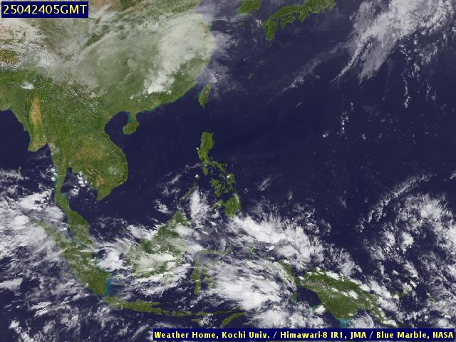
Over the past 24 hours the system has become better organized with strong convection forming near or over its possible LLC and some banding is evident in satellite images. If the current organization trend continues, it has a good change to become a tropical depression over the next 36 to 48 hours, maybe less! NOGAPS also shows a system developing in this area over the mentioned period of time. Even if it develops or not, the Central and Southern Philippines islands should expect heavy rain and some gusty winds as the system continues moving westward.
Last edited by HURAKAN on Thu Jan 26, 2006 7:59 am, edited 6 times in total.
0 likes   

Coredesat

#2 Postby Coredesat » Fri Jan 20, 2006 6:54 pm

20/2033 UTC 6.9N 130.8E T1.0/1.0 98W
0 likes   

User avatar
HURAKAN
Professional-Met
Professional-Met
Posts: 46086
Age: 38
Joined: Thu May 20, 2004 4:34 pm
Location: Key West, FL
Contact:

#3 Postby HURAKAN » Fri Jan 20, 2006 11:32 pm

21/0233 UTC 7.2N 129.7E T1.5/1.5 98W -- West Pacific Ocean
0 likes   

Matt-hurricanewatcher

#4 Postby Matt-hurricanewatcher » Fri Jan 20, 2006 11:44 pm

Looks like its getting close to become our first depression.
0 likes   

User avatar
senorpepr
Military Met/Moderator
Posts: 12542
Age: 43
Joined: Fri Aug 22, 2003 9:22 pm
Location: Mackenbach, Germany
Contact:

#5 Postby senorpepr » Sat Jan 21, 2006 8:12 am

Officially it is our first depression.

According to JMA (Japan), TD 0601 has formed to the southeast of the Philippines.

Image
Image

PAGASA (Philippines) has issued the following:

Code: Select all

Weather
Issued At: 5:00 p.m., 21 January 2006
Synopsis :  At 2:00 p.m. today, a Tropical Depression "AGATON" was estimated based on satellite and surface data at 220 kms east northeast of Hinatuan, Surigao Del Sur (9.0°N 128.3°E) With maximum sustained winds of 45 kph near the center. It is moving west northwest at 15 kph.


[/code]


////

Looks like northern Mindanao and the eastern Visayas regions will be affected in the near future with the rest of Visayas and southern parts of Luzon getting into the action in a couple of days.
Last edited by senorpepr on Sat Jan 21, 2006 5:34 pm, edited 1 time in total.
0 likes   

User avatar
senorpepr
Military Met/Moderator
Posts: 12542
Age: 43
Joined: Fri Aug 22, 2003 9:22 pm
Location: Mackenbach, Germany
Contact:

#6 Postby senorpepr » Sat Jan 21, 2006 8:19 am

PASAGA has issued a Public Storm Warning for the following...

In Luzon: None.
In Visayas: Leyte, Camotes Island, and Samar Provinces.
In Mindanao: Surigao Provinces, Dinagat Island, Siargao Island, and Agusan Del Norte.

Expect 30-60 kph (19-37 mph) winds.

http://www.pagasa.dost.gov.ph/wb/tc_up.html
0 likes   

User avatar
mike815
Category 5
Category 5
Posts: 1460
Joined: Fri Jul 22, 2005 8:21 am
Location: palm bay fl

#7 Postby mike815 » Sat Jan 21, 2006 8:20 am

so this is not an invest anymore?
0 likes   

User avatar
senorpepr
Military Met/Moderator
Posts: 12542
Age: 43
Joined: Fri Aug 22, 2003 9:22 pm
Location: Mackenbach, Germany
Contact:

#8 Postby senorpepr » Sat Jan 21, 2006 8:23 am

mike815 wrote:so this is not an invest anymore?


Officially, this is a tropical depression. However, JTWC and NRL are still carrying it as an invest.


I've updated the S2K Worldwide Tropical Update to show satellite imagery and links from JMA and PAGASA. When JTWC finally upgrades to 01W, it'll add those links.

http://tropicalupdate.storm2k.org/
http://tropicalupdates.nhcwx.com/wpac.htm
0 likes   

User avatar
mike815
Category 5
Category 5
Posts: 1460
Joined: Fri Jul 22, 2005 8:21 am
Location: palm bay fl

#9 Postby mike815 » Sat Jan 21, 2006 8:28 am

ok thanks
0 likes   

User avatar
HURAKAN
Professional-Met
Professional-Met
Posts: 46086
Age: 38
Joined: Thu May 20, 2004 4:34 pm
Location: Key West, FL
Contact:

#10 Postby HURAKAN » Sat Jan 21, 2006 9:07 am

Image
0 likes   

User avatar
P.K.
Professional-Met
Professional-Met
Posts: 5149
Joined: Thu Sep 23, 2004 5:57 pm
Location: Watford, England
Contact:

#11 Postby P.K. » Sat Jan 21, 2006 9:38 am

According to JMA (Japan), TD 0601 has formed to the southeast of the Philippines.


TDs aren't numbered by the JMA.

The next name on the list is Chanchu. Just waiting for the first advisory from the JMA which should be out soon. :)

WWJP25 RJTD 211200
WARNING AND SUMMARY 211200.
WARNING VALID 221200.
WARNING IS UPDATED EVERY 6 HOURS.
STORM WARNING.
DEVELOPING LOW 996 HPA
AT 33N 145E SEA EAST OF JAPAN MOVING EAST 25 KNOTS.
OCCLUDED FRONT FROM 33N 145E TO 33N 146E 33N 147E.
WARM FRONT FROM 33N 147E TO 32N 150E 30N 153E.
COLD FRONT FROM 33N 147E TO 30N 145E 28N 141E 25N 138E 24N 135E.
EXPECTED WINDS 30 TO 55 KNOTS WITHIN 800 MILES OF LOW
FOR NEXT 12 HOURS.
FORECAST POSITION FOR 221200UTC AT 42N 158E WITH UNCERTAINTY OF 100
MILES RADIUS.
GALE WARNING.
DEVELOPED LOW 1000 HPA
AT 54N 148E SEA OF OKHOTSK MOVING WESTNORTHWEST 10 KNOTS.
WINDS 30 TO 40 KNOTS WITHIN 400 MILES OF LOW.
GALE WARNING.
DEVELOPED LOW 996 HPA
AT 51N 166E SEA EAST OF KAMCHATKA MOVING WEST 15 KNOTS.
WINDS 30 TO 40 KNOTS WITHIN 500 MILES OF LOW NORTH SEMICIRCLE AND 400
MILES ELSEWHERE.
GALE WARNING.
NORTHERLY TO NORTHEASTERLY WINDS 30 TO 35 KNOTS PREVAILING OVER EAST
CHINA SEA.
GALE WARNING.
WESTERLY TO NORTHWESTERLY WINDS 30 TO 40 KNOTS PREVAILING OVER WATERS
BOUNDED BY 36N 180E 39N 170E 47N 170E 44N 180E 36N 180E.
WARNING.
DENSE FOG OBSERVED LOCALLY OVER NORTHERN PART OF SOUTH CHINA SEA.
SUMMARY.
TROPICAL DEPRESSION 1004 HPA AT 09N 130E WNW SLOWLY.
HIGH 1020 HPA AT 33N 170E EAST 25 KT.


JAPAN METEOROLOGICAL AGENCY.=
Last edited by P.K. on Sat Jan 21, 2006 9:45 am, edited 1 time in total.
0 likes   

User avatar
HURAKAN
Professional-Met
Professional-Met
Posts: 46086
Age: 38
Joined: Thu May 20, 2004 4:34 pm
Location: Key West, FL
Contact:

#12 Postby HURAKAN » Sat Jan 21, 2006 9:42 am

Image

LOTS OF CONVECTION, BUT NO SIGN OF BANDS.
0 likes   

User avatar
senorpepr
Military Met/Moderator
Posts: 12542
Age: 43
Joined: Fri Aug 22, 2003 9:22 pm
Location: Mackenbach, Germany
Contact:

#13 Postby senorpepr » Sat Jan 21, 2006 10:17 am

P.K. wrote:
According to JMA (Japan), TD 0601 has formed to the southeast of the Philippines.


TDs aren't numbered by the JMA.

The next name on the list is Chanchu. Just waiting for the first advisory from the JMA which should be out soon. :)


That's right. I've said it before and I'll say it again... I shouldn't make posts just before going to bed.

I'll leave it as 0601 for now because A) I'm really too tired to make the needed changes to the webpage and B) there is a good chance I'll just have to change it back anyway.

But yes... TD aren't numbered by JMA.
0 likes   

User avatar
P.K.
Professional-Met
Professional-Met
Posts: 5149
Joined: Thu Sep 23, 2004 5:57 pm
Location: Watford, England
Contact:

#14 Postby P.K. » Sat Jan 21, 2006 10:38 am

lol, that would explain why the JMA bit you posted was 35 degrees further north than the TD then. :wink: :lol: (I had noticed but didn't want to say anything :lol: )
0 likes   

User avatar
HURAKAN
Professional-Met
Professional-Met
Posts: 46086
Age: 38
Joined: Thu May 20, 2004 4:34 pm
Location: Key West, FL
Contact:

#15 Postby HURAKAN » Sat Jan 21, 2006 11:11 am

21/1433 UTC 9.2N 128.7E T1.5/1.5 98W -- West Pacific Ocean

NO CHANGE.
0 likes   

JonathanBelles
Professional-Met
Professional-Met
Posts: 11430
Age: 35
Joined: Sat Dec 24, 2005 9:00 pm
Location: School: Florida State University (Tallahassee, FL) Home: St. Petersburg, Florida
Contact:

#16 Postby JonathanBelles » Sat Jan 21, 2006 12:05 pm

does anyone have a west pacific tracking chart?
0 likes   

JonathanBelles
Professional-Met
Professional-Met
Posts: 11430
Age: 35
Joined: Sat Dec 24, 2005 9:00 pm
Location: School: Florida State University (Tallahassee, FL) Home: St. Petersburg, Florida
Contact:

#17 Postby JonathanBelles » Sat Jan 21, 2006 12:08 pm

and is it agaton or chanchu?
0 likes   

User avatar
WindRunner
Category 5
Category 5
Posts: 5806
Age: 34
Joined: Fri Jul 29, 2005 8:07 pm
Location: Warrenton, VA, but Albany, NY for school
Contact:

#18 Postby WindRunner » Sat Jan 21, 2006 12:21 pm

fact789 wrote:and is it agaton or chanchu?


Agaton is the Phillipine center's name for it, which is not official. The JMA does the official naming for the WPAC, and that name will be Chanchu as soon as the storm reaches TS strength per the JMA.
0 likes   

JonathanBelles
Professional-Met
Professional-Met
Posts: 11430
Age: 35
Joined: Sat Dec 24, 2005 9:00 pm
Location: School: Florida State University (Tallahassee, FL) Home: St. Petersburg, Florida
Contact:

#19 Postby JonathanBelles » Sat Jan 21, 2006 12:29 pm

ok so the phillipenes do the naming for td's? and Japan does naming for TS's and tyhoop's?
0 likes   

User avatar
HURAKAN
Professional-Met
Professional-Met
Posts: 46086
Age: 38
Joined: Thu May 20, 2004 4:34 pm
Location: Key West, FL
Contact:

#20 Postby HURAKAN » Sat Jan 21, 2006 1:32 pm

fact789 wrote:ok so the phillipenes do the naming for td's? and Japan does naming for TS's and tyhoop's?


No. David Michael V. Padua, the owner of Typhoon2000.ph, a Philippine Meteorologist and/or weather enthusiast has designated a name list that he uses to name tropical depressions/tropical storm/typhoons. The Philippines don't do any type of naming.

These are his archives:
http://www.typhoon2000.ph/archives.htm
0 likes   


Return to “Talkin' Tropics”

Who is online

Users browsing this forum: jconsor, kenayers, WeatherCat and 70 guests