South Pacific: TROPICAL CYCLONE URMIL
Moderator: S2k Moderators
Forum rules

The posts in this forum are NOT official forecasts and should not be used as such. They are just the opinion of the poster and may or may not be backed by sound meteorological data. They are NOT endorsed by any professional institution or STORM2K. For official information, please refer to products from the National Hurricane Center and National Weather Service.
-
JonathanBelles
- Professional-Met

- Posts: 11430
- Age: 35
- Joined: Sat Dec 24, 2005 9:00 pm
- Location: School: Florida State University (Tallahassee, FL) Home: St. Petersburg, Florida
- Contact:
-
HURAKAN

- Professional-Met
- Posts: 46086
- Age: 38
- Joined: Thu May 20, 2004 4:34 pm
- Location: Key West, FL
- Contact:
Tropical Disturbance Advisory Number B6 issued from RSMC NADI
Jan 15/0202 UTC 2006 UTC.
Tropical Cyclone URMIL 06F [985hPa] centre was located near 23.8S
171.3W at 150000 UTC. Position fair based on HR MTSAT EIR/VIS imagery
with animation. Cyclone moving south-southeast at 20 knots. Maximum
10-minute average winds estimated at 50 knots close to the centre
decreasing to 35 knots in the next 12 to 24 hours. Expect winds over
47 knots within 20 miles of centre and over 33 knots within 100 miles
of centre.
Urmil continues to weaken. Deep convection displaced about 0.5
degrees south of exposed llcc. Overall organisation decreasing
significantly. Shear pattern yields a DT2.5. MET=2.5, PT=2.5. FT
based on DT and PT, thus T2.5/3.5/W0.5/24hrs. Urmil remains under
divergent 250-hPa region but steadily moving into stronger shear and
cooler SSTs. Urmil is being steered poleward by deep northwest winds.
FORECAST:
12hrs valid at 151200 UTC near 27.4S 169.8W mov SSE at 20kt with 45kt
close to centre.
24hrs valid at 160000 UTC near 29.4S 168.2W mov SSE at 16kt with 35kt
close to centre.
OUTLOOK:
36hrs valid at 161200 UTC near 31.1S 166.8W mov SSE at 14kt with 30kt
close to the centre.
48hrs valid at 170000 UTC near 32.8S 165.2W mov SSE at 13kt with 25kt
close to the centre.
The next Tropical Disturbance Advisory on Tropical Cyclone URMIL will
be issued around 150800 UTC unless centre is south of 25 South.
0 likes
-
JonathanBelles
- Professional-Met
- Posts: 11430
- Age: 35
- Joined: Sat Dec 24, 2005 9:00 pm
- Location: School: Florida State University (Tallahassee, FL) Home: St. Petersburg, Florida
- Contact:


-
JonathanBelles
- Professional-Met
- Posts: 11430
- Age: 35
- Joined: Sat Dec 24, 2005 9:00 pm
- Location: School: Florida State University (Tallahassee, FL) Home: St. Petersburg, Florida
- Contact:
-
HURAKAN
- Professional-Met
- Posts: 46086
- Age: 38
- Joined: Thu May 20, 2004 4:34 pm
- Location: Key West, FL
- Contact:
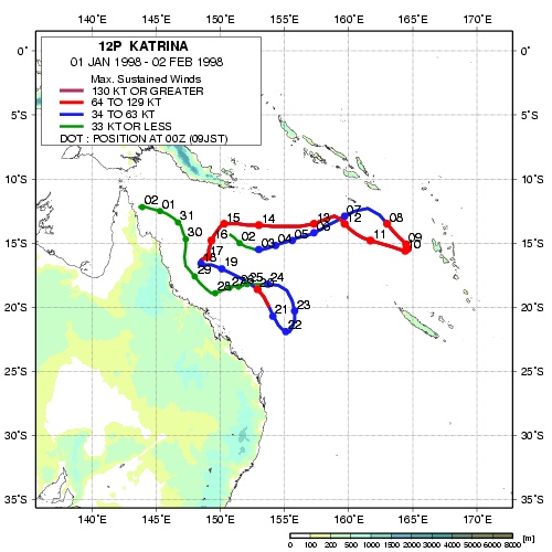
The South Pacific can have crazy storms like Katrina in 1999, yes, Katrina.
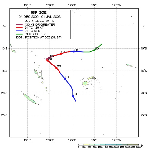
Or very intense like Zoe in 2002 - 2003 (155 knots / 180 mph).
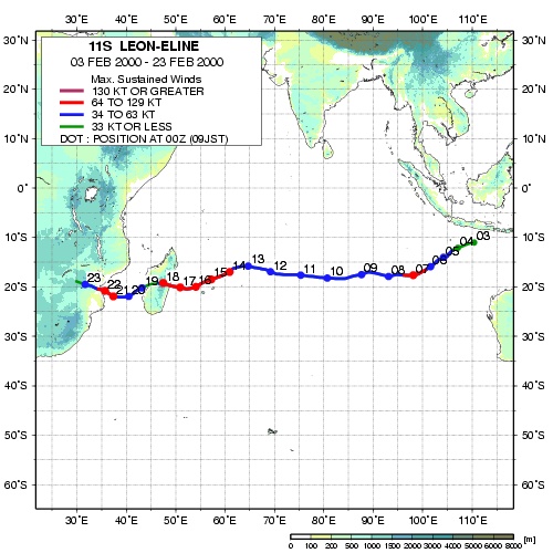
The South Indian Ocean has some oddities too that are very interesting. For example, Leon-Eline in 2000.
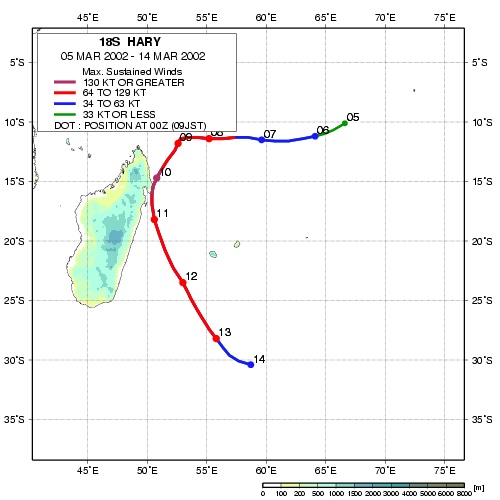
Or like TC Hary that made landfall in Madagascar in 2002 as a Category 5.
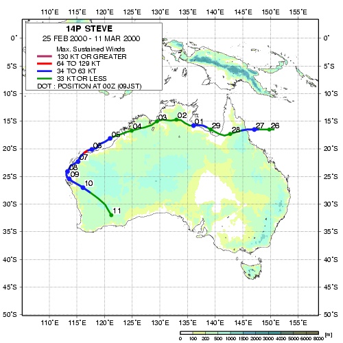
Australia is the largest landmass threatened by tropical cyclones in the southern hemisphere. Fortunately, it's an sparsely populated continent with most of its population living in areas not affected by tropical systems like Perth, Sydney, Melbourne, and others. These cities are too far south for a true tropical cyclone to affect them. The only major city in the danger zone is Darwin and unfortunately it got a major blow in 1974 by TC Tracy, so far the worse tropical cyclone in Australian history.
A crazy cyclone, TC Steve, 2000.
Or very intense like Zoe in 2002 - 2003 (155 knots / 180 mph).
The South Indian Ocean has some oddities too that are very interesting. For example, Leon-Eline in 2000.
Or like TC Hary that made landfall in Madagascar in 2002 as a Category 5.
Australia is the largest landmass threatened by tropical cyclones in the southern hemisphere. Fortunately, it's an sparsely populated continent with most of its population living in areas not affected by tropical systems like Perth, Sydney, Melbourne, and others. These cities are too far south for a true tropical cyclone to affect them. The only major city in the danger zone is Darwin and unfortunately it got a major blow in 1974 by TC Tracy, so far the worse tropical cyclone in Australian history.
A crazy cyclone, TC Steve, 2000.
0 likes
-
senorpepr

- Military Met/Moderator

- Posts: 12542
- Age: 43
- Joined: Fri Aug 22, 2003 9:22 pm
- Location: Mackenbach, Germany
- Contact:
Okay... I realize this is a bit late, but I finally got Urmil added to the S2K Worldwide Tropical Update page.
http://tropicalupdates.nhcwx.com/
I'm also in the process of making some changes to the page. It's been a little crazy around here, though...
http://tropicalupdates.nhcwx.com/
I'm also in the process of making some changes to the page. It's been a little crazy around here, though...
0 likes
-
Matt-hurricanewatcher
http://www.ncdc.noaa.gov/oa/rsad/gibbs/ ... html#image
You can track Katrina...It lasted 33 days in which makes it the longest cyclone to ever live on earth.
You can track Katrina...It lasted 33 days in which makes it the longest cyclone to ever live on earth.
0 likes
-
P.K.

- Professional-Met
- Posts: 5149
- Joined: Thu Sep 23, 2004 5:57 pm
- Location: Watford, England
- Contact:
Extratropical:
GALE WARNING 191
This affects ocean area/s: SUBTROPIC and PACIFIC
AT 150600UTC
Low 989hPa, formerly cyclone Urmil, near 25S 170W, moving
southsoutheast 20kt.
Over waters south of 25S:
1. Within 60 miles of low: Clockwise 45kt.
2. Outside area 1 and within 150 miles of low: Clockwise 35kt.
Areas of gales moving with low.
This warning cancels and replaces warning 188.
0 likes
-
Coredesat
WTPS32 PGTW 150900
MSGID/GENADMIN/NAVPACMETOCCEN PEARL HARBOR HI/JTWC//
SUBJ/TROPICAL CYCLONE WARNING//
RMKS/
1. TROPICAL CYCLONE 07P (URMIL) WARNING NR 003
01 ACTIVE TROPICAL CYCLONE IN SOUTHPAC
MAX SUSTAINED WINDS BASED ON ONE-MINUTE AVERAGE
---
WARNING POSITION:
150600Z --- NEAR 26.0S 170.0W
MOVEMENT PAST SIX HOURS - 150 DEGREES AT 24 KTS
POSITION ACCURATE TO WITHIN 060 NM
POSITION BASED ON CENTER LOCATED BY SATELLITE
PRESENT WIND DISTRIBUTION:
MAX SUSTAINED WINDS - 045 KT, GUSTS 055 KT
DISSIPATING AS A SIGNIFICANT TROPICAL CYCLONE OVER WATER
RADIUS OF 034 KT WINDS - 035 NM NORTHEAST QUADRANT
045 NM SOUTHEAST QUADRANT
035 NM SOUTHWEST QUADRANT
045 NM NORTHWEST QUADRANT
REPEAT POSIT: 26.0S 170.0W
---
FORECASTS:
12 HRS, VALID AT:
151800Z --- 28.5S 167.7W
MAX SUSTAINED WINDS - 035 KT, GUSTS 045 KT
DISSIPATING AS A SIGNIFICANT TROPICAL CYCLONE OVER WATER
VECTOR TO 24 HR POSIT: 130 DEG/ 14 KTS
---
24 HRS, VALID AT:
160600Z --- 30.2S 165.2W
MAX SUSTAINED WINDS - 025 KT, GUSTS 035 KT
DISSIPATED AS A SIGNIFICANT TROPICAL CYCLONE OVER WATER
---
REMARKS:
150900Z POSITION NEAR 26.6S 169.4W.
TROPICAL CYCLONE (TC) 07P (URMIL), LOCATED APPROXIMATELY 630 NM WEST-
SOUTHWEST OF RAROTONGA, COOK ISLANDS HAS TRACKED SOUTH-SOUTHEAST AT
24 KNOTS OVER THE PAST SIX HOURS. RECENT ENHANCED WATER VAPOR IMAGERY
REVEALS A COMPLETE BREAKDOWN IN CORE CONVECTION. DURING NEXT 24 HOURS
TC 07P WILL DISSIPATE AS IT IS ABSORBED INTO THE MIDLATITUDE
WESTERLY FLOW. THIS IS THE FINAL WARNING ON THIS SYSTEM BY THE JOINT
TYPHOON WARNING CENTER (NAVPACMETOCCEN). THE SYSTEM WILL BE CLOSELY
MONITORED FOR SIGNS OF REGENERATION. MAXIMUM SIGNIFICANT WAVE HEIGHT
AT 150600Z IS 10 FEET.//
NNNN
0 likes
-
MiamiensisWx
-
JonathanBelles
- Professional-Met
- Posts: 11430
- Age: 35
- Joined: Sat Dec 24, 2005 9:00 pm
- Location: School: Florida State University (Tallahassee, FL) Home: St. Petersburg, Florida
- Contact:
Who is online
Users browsing this forum: No registered users and 69 guests