Epsilon,Final Comments,Sat Pics

This is the general tropical discussion area. Anyone can take their shot at predicting a storms path.

Moderator: S2k Moderators

Forum rules

The posts in this forum are NOT official forecasts and should not be used as such. They are just the opinion of the poster and may or may not be backed by sound meteorological data. They are NOT endorsed by any professional institution or STORM2K. For official information, please refer to products from the National Hurricane Center and National Weather Service.

Help Support Storm2K
Message
Author
User avatar
TheEuropean
Professional-Met
Professional-Met
Posts: 1797
Age: 60
Joined: Tue Sep 20, 2005 3:17 pm
Location: Voerde, Germany
Contact:

#361 Postby TheEuropean » Sun Dec 04, 2005 6:20 pm

Tampa Bay Hurricane wrote:Well-Defined structure....


But open to the southeast...
0 likes   

User avatar
cjrciadt
S2K Supporter
S2K Supporter
Posts: 1616
Joined: Mon Aug 22, 2005 1:11 pm
Location: Kissimmee, FL

#362 Postby cjrciadt » Sun Dec 04, 2005 6:32 pm

Image
0 likes   

User avatar
TheEuropean
Professional-Met
Professional-Met
Posts: 1797
Age: 60
Joined: Tue Sep 20, 2005 3:17 pm
Location: Voerde, Germany
Contact:

#363 Postby TheEuropean » Sun Dec 04, 2005 6:36 pm

High and increasing shear to the southwest of Epsilon. IMO tomorrow it will be downgraded to a storm again.
0 likes   

User avatar
cycloneye
Admin
Admin
Posts: 148497
Age: 69
Joined: Thu Oct 10, 2002 10:54 am
Location: San Juan, Puerto Rico

#364 Postby cycloneye » Sun Dec 04, 2005 7:34 pm

04/2345 UTC 34.3N 37.9W T4.0/4.5 EPSILON -- Atlantic Ocean


No change from this afternoons T Numbers so it's still a hurricane tonight between 65-70kts.
0 likes   
Visit the Caribbean-Central America Weather Thread where you can find at first post web cams,radars
and observations from Caribbean basin members Click Here

User avatar
WindRunner
Category 5
Category 5
Posts: 5806
Age: 34
Joined: Fri Jul 29, 2005 8:07 pm
Location: Warrenton, VA, but Albany, NY for school
Contact:

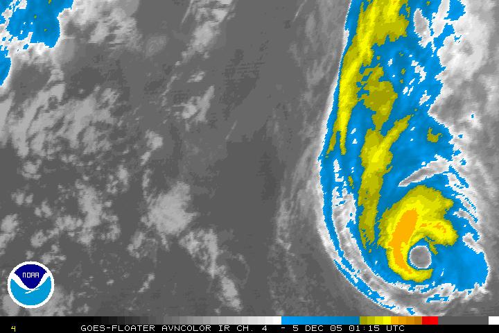
#365 Postby WindRunner » Sun Dec 04, 2005 7:54 pm

Minimal hurricane now, 00Z.

DISCLAIMER...NUMERICAL MODELS ARE SUBJECT TO LARGE ERRORS.
PLEASE REFER TO TPC/NHC OFFICIAL FORECASTS FOR TROPICAL CYCLONES.

NATIONAL HURRICANE CENTER NORTH ATLANTIC OBJECTIVE AIDS FOR

HURRICANE EPSILON (AL292005) ON 20051205 0000 UTC

...00 HRS... ...12 HRS... ...24 HRS... ...36 HRS...
051205 0000 051205 1200 051206 0000 051206 1200

LAT LON LAT LON LAT LON LAT LON
BAMD 34.3N 37.8W 34.8N 35.0W 35.0N 33.0W 34.3N 32.2W
BAMM 34.3N 37.8W 34.0N 35.9W 33.2N 34.8W 32.1N 35.0W
A98E 34.3N 37.8W 34.5N 36.0W 34.6N 33.9W 34.2N 32.4W
LBAR 34.3N 37.8W 34.6N 35.3W 34.6N 33.2W 33.9N 31.6W
SHIP 65KTS 54KTS 45KTS 37KTS
DSHP 65KTS 54KTS 45KTS 37KTS

...48 HRS... ...72 HRS... ...96 HRS... ..120 HRS...
051207 0000 051208 0000 051209 0000 051210 0000

LAT LON LAT LON LAT LON LAT LON
BAMD 32.8N 33.1W 29.8N 38.4W 22.3N 43.3W 17.3N 46.2W
BAMM 31.0N 36.9W 28.6N 42.6W 24.6N 47.4W 22.3N 50.4W
A98E 33.6N 32.1W 32.4N 31.3W 29.3N 33.8W 23.2N 32.7W
LBAR 32.9N 31.0W 29.5N 30.4W 28.3N 30.9W 26.3N 30.1W
SHIP 29KTS 0KTS 0KTS 0KTS
DSHP 29KTS 0KTS 0KTS 0KTS

...INITIAL CONDITIONS...
LATCUR = 34.3N LONCUR = 37.8W DIRCUR = 90DEG SPDCUR = 8KT
LATM12 = 34.3N LONM12 = 39.8W DIRM12 = 92DEG SPDM12 = 10KT
LATM24 = 34.3N LONM24 = 42.3W
WNDCUR = 65KT RMAXWD = 20NM WNDM12 = 75KT
CENPRS = 985MB OUTPRS = 1008MB OUTRAD = 200NM SDEPTH = D
RD34NE = 75NM RD34SE = 75NM RD34SW = 100NM RD34NW = 75NM
0 likes   

User avatar
dixiebreeze
S2K Supporter
S2K Supporter
Posts: 5140
Joined: Wed Sep 03, 2003 5:07 pm
Location: crystal river, fla.

#366 Postby dixiebreeze » Sun Dec 04, 2005 8:27 pm

The 5-day cone shows Epsilon on a track toward Puerto Rico:

http://www.nhc.noaa.gov/

I know, I know, it will likely be gone long before then.
0 likes   

Matt-hurricanewatcher

#367 Postby Matt-hurricanewatcher » Sun Dec 04, 2005 8:30 pm

It is looking better then it did 6 hours ago. Deeper convection to the northwest quad. Still a hole on the southeast. Still looks to be 70 knots...
0 likes   

Matt-hurricanewatcher

#368 Postby Matt-hurricanewatcher » Sun Dec 04, 2005 8:31 pm

dixiebreeze wrote:The 5-day cone shows Epsilon on a track toward Puerto Rico:

http://www.nhc.noaa.gov/

I know, I know, it will likely be gone long before then.


Don't sell the farm on that! :wink:
0 likes   

Derek Ortt

#369 Postby Derek Ortt » Sun Dec 04, 2005 8:40 pm

well...


we are seeing the lowering of the intensity without any good reason
0 likes   

MiamiensisWx

#370 Postby MiamiensisWx » Sun Dec 04, 2005 9:19 pm

Image
0 likes   

User avatar
TheEuropean
Professional-Met
Professional-Met
Posts: 1797
Age: 60
Joined: Tue Sep 20, 2005 3:17 pm
Location: Voerde, Germany
Contact:

#371 Postby TheEuropean » Sun Dec 04, 2005 9:35 pm

Take this one, it won't reload:

Image
0 likes   

Scorpion

#372 Postby Scorpion » Sun Dec 04, 2005 9:43 pm

Convection looks deeper.
0 likes   

User avatar
TheEuropean
Professional-Met
Professional-Met
Posts: 1797
Age: 60
Joined: Tue Sep 20, 2005 3:17 pm
Location: Voerde, Germany
Contact:

#373 Postby TheEuropean » Sun Dec 04, 2005 9:54 pm

Scorpion wrote:Convection looks deeper.


Yep and wrapping around the center again...
0 likes   

Matt-hurricanewatcher

#374 Postby Matt-hurricanewatcher » Sun Dec 04, 2005 10:01 pm

THe thing is becoming better organized in the nhc down the winds 5 knots??? Are they trying to cover this #$# I think so!
0 likes   

User avatar
JamesFromMaine2
Category 4
Category 4
Posts: 989
Joined: Tue Jul 19, 2005 1:38 am
Location: Portland Maine USA
Contact:

#375 Postby JamesFromMaine2 » Sun Dec 04, 2005 10:03 pm

I don't see any breaks in the eye wall at all yeah theres breaks in the deeper convection around the eye but theres still convection all the way around.
0 likes   

User avatar
JamesFromMaine2
Category 4
Category 4
Posts: 989
Joined: Tue Jul 19, 2005 1:38 am
Location: Portland Maine USA
Contact:

#376 Postby JamesFromMaine2 » Sun Dec 04, 2005 10:06 pm

I say that the Intensity forcasts for this storm needs to be thrown out all togiether since this thing hasn't been following any of the forcasts! They should just take it one advisory at a time and not try to forcast the intensity until it gets close to land if it does! lol
0 likes   

User avatar
TheEuropean
Professional-Met
Professional-Met
Posts: 1797
Age: 60
Joined: Tue Sep 20, 2005 3:17 pm
Location: Voerde, Germany
Contact:

#377 Postby TheEuropean » Sun Dec 04, 2005 10:06 pm

JamesFromMaine2 wrote:I don't see any breaks in the eye wall at all yeah theres breaks in the deeper convection around the eye but theres still convection all the way around.


There was a break, but convection is wrapping around the center again.
0 likes   

User avatar
WindRunner
Category 5
Category 5
Posts: 5806
Age: 34
Joined: Fri Jul 29, 2005 8:07 pm
Location: Warrenton, VA, but Albany, NY for school
Contact:

#378 Postby WindRunner » Sun Dec 04, 2005 10:15 pm

Dvoraks should be going up to 4.5 again shortly, looking good now.
0 likes   

User avatar
HURAKAN
Professional-Met
Professional-Met
Posts: 46086
Age: 38
Joined: Thu May 20, 2004 4:34 pm
Location: Key West, FL
Contact:

#379 Postby HURAKAN » Sun Dec 04, 2005 10:31 pm

By the way, the advisory at 10 PM was Epsilon's # 23. Delta only had 20!
0 likes   

HurricaneBill
Category 5
Category 5
Posts: 3420
Joined: Sun Apr 11, 2004 5:51 pm
Location: East Longmeadow, MA, USA

#380 Postby HurricaneBill » Sun Dec 04, 2005 10:54 pm

brunota2003 wrote:NO, Finding Nemo...!!!


The Incredible Mr. Limpet!
0 likes   


Return to “Talkin' Tropics”

Who is online

Users browsing this forum: aspen, Team Ghost and 300 guests