Hurricane Wilma Recon Discussion Thread

This is the general tropical discussion area. Anyone can take their shot at predicting a storms path.

Moderator: S2k Moderators

Forum rules

The posts in this forum are NOT official forecasts and should not be used as such. They are just the opinion of the poster and may or may not be backed by sound meteorological data. They are NOT endorsed by any professional institution or STORM2K. For official information, please refer to products from the National Hurricane Center and National Weather Service.

Help Support Storm2K
Message
Author
User avatar
WindRunner
Category 5
Category 5
Posts: 5806
Age: 34
Joined: Fri Jul 29, 2005 8:07 pm
Location: Warrenton, VA, but Albany, NY for school
Contact:

#221 Postby WindRunner » Tue Oct 18, 2005 5:16 pm

senorpepr wrote:
WindRunner wrote:EYEWALL 025 SPL 1675N08152W 2141 LST WND 082 MBL WND 09087
AEV 20507 DLM WND 10083 967859 WL150 08588 156 =

977mb winds: N (N/A°) @ N/A mph
967mb winds: ENE (75°) @ 90 mph
960mb winds: E (85°) @ 108 mph
953mb winds: E (85°) @ 98 mph
920mb winds: ESE (105°) @ 101 mph
880mb winds: ESE (110°) @ 89 mph
859mb winds: ESE (110°) @ 92 mph
842mb winds: ESE (110°) @ 90 mph

Look at the dropsonde here, in the first eyewall pass. That should support at least a 5kt upgrade, if not 10.


Not really... 108mph at 960mb would equal around 80 mph.


But doesn't that 90 at 967mb mean much, or do the winds start to drop off quick as you go down from there?
0 likes   

User avatar
senorpepr
Military Met/Moderator
Posts: 12542
Age: 43
Joined: Fri Aug 22, 2003 9:22 pm
Location: Mackenbach, Germany
Contact:

#222 Postby senorpepr » Tue Oct 18, 2005 5:16 pm

Stratosphere747 wrote:
senorpepr wrote:
Stratosphere747 wrote:Latest dropsonde shows it stationary?

Movement reflected in the 7pm advisory?


Slight westward drift.


Enough of a trend or will they keep the WNW heading on the next advisory?


That will depend on how they are feeling. :wink:
0 likes   

superfly

#223 Postby superfly » Tue Oct 18, 2005 5:16 pm

southfloridawx2005 wrote:Category Three Hurricane:

* Air pressure: 945-964 mb.


And here we have a cat 1 963mb storm. :D
0 likes   

User avatar
senorpepr
Military Met/Moderator
Posts: 12542
Age: 43
Joined: Fri Aug 22, 2003 9:22 pm
Location: Mackenbach, Germany
Contact:

#224 Postby senorpepr » Tue Oct 18, 2005 5:17 pm

WindRunner wrote:
senorpepr wrote:
WindRunner wrote:EYEWALL 025 SPL 1675N08152W 2141 LST WND 082 MBL WND 09087
AEV 20507 DLM WND 10083 967859 WL150 08588 156 =

977mb winds: N (N/A°) @ N/A mph
967mb winds: ENE (75°) @ 90 mph
960mb winds: E (85°) @ 108 mph
953mb winds: E (85°) @ 98 mph
920mb winds: ESE (105°) @ 101 mph
880mb winds: ESE (110°) @ 89 mph
859mb winds: ESE (110°) @ 92 mph
842mb winds: ESE (110°) @ 90 mph

Look at the dropsonde here, in the first eyewall pass. That should support at least a 5kt upgrade, if not 10.


Not really... 108mph at 960mb would equal around 80 mph.


But doesn't that 90 at 967mb mean much, or do the winds start to drop off quick as you go down from there?


At that level... about 90% or still around 80 mph.
0 likes   

HenkL
S2K Supporter
S2K Supporter
Posts: 2401
Joined: Fri Sep 10, 2004 5:33 pm
Location: Groningen, The Netherlands
Contact:

#225 Postby HenkL » Tue Oct 18, 2005 5:18 pm

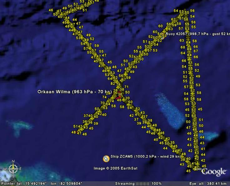
Picture of the flight so far, numbers are max flight level wind data each 30 seconds.
Image
0 likes   

User avatar
senorpepr
Military Met/Moderator
Posts: 12542
Age: 43
Joined: Fri Aug 22, 2003 9:22 pm
Location: Mackenbach, Germany
Contact:

#226 Postby senorpepr » Tue Oct 18, 2005 5:19 pm

HenkL wrote:Picture of the flight so far, numbers are max flight level wind data each 30 seconds.
http://www.weerwoord.be/uploads/0102005194714.jpg


Great visual!
0 likes   

User avatar
JamesFromMaine2
Category 4
Category 4
Posts: 989
Joined: Tue Jul 19, 2005 1:38 am
Location: Portland Maine USA
Contact:

#227 Postby JamesFromMaine2 » Tue Oct 18, 2005 5:22 pm

will they be going through the center again or not?
0 likes   

User avatar
artist
Category 5
Category 5
Posts: 9792
Joined: Mon Jun 06, 2005 3:26 pm
Location: West Palm

#228 Postby artist » Tue Oct 18, 2005 5:24 pm

absolutely LOVE that visual! Is it something that is always done or just your current handy work? :D
0 likes   

User avatar
tronbunny
S2K Supporter
S2K Supporter
Posts: 1558
Joined: Wed Sep 01, 2004 1:18 am
Location: Central FL

#229 Postby tronbunny » Tue Oct 18, 2005 5:24 pm

senorpepr wrote:
HenkL wrote:Picture of the flight so far, numbers are max flight level wind data each 30 seconds.
http://www.weerwoord.be/uploads/0102005194714.jpg


Great visual!


I'll second that!
0 likes   

curtadams
S2K Supporter
S2K Supporter
Posts: 1122
Joined: Sun Aug 28, 2005 7:57 pm
Location: Orange, California
Contact:

#230 Postby curtadams » Tue Oct 18, 2005 5:27 pm

superfly wrote:
southfloridawx2005 wrote:Category Three Hurricane:

* Air pressure: 945-964 mb.


And here we have a cat 1 963mb storm. :D


A WEAK cat1 storm, from recon so far. Bizarre!!
0 likes   

JTD
Category 5
Category 5
Posts: 1558
Joined: Sun Nov 02, 2003 6:35 pm

#231 Postby JTD » Tue Oct 18, 2005 5:32 pm

Today, it uses the pressure drops to grow in geographic size.

Tommorow, it becames an extremely dangerous hurricane.
0 likes   

Brent
S2K Supporter
S2K Supporter
Posts: 38264
Age: 37
Joined: Sun May 16, 2004 10:30 pm
Location: Tulsa Oklahoma
Contact:

#232 Postby Brent » Tue Oct 18, 2005 5:32 pm

The winds will respond... remember Katrina? It dropped into the 940's and stayed a marginal 3 all day Saturday and then that night... well, you know the rest.
0 likes   
#neversummer

User avatar
Weatherfreak14
Category 5
Category 5
Posts: 1383
Joined: Sat Sep 24, 2005 3:40 pm
Location: Beaufort, SC
Contact:

#233 Postby Weatherfreak14 » Tue Oct 18, 2005 5:33 pm

Yes I agree, by tommrow eve it should be a cat 3.
0 likes   

Scorpion

#234 Postby Scorpion » Tue Oct 18, 2005 5:33 pm

jason0509 wrote:Today, it uses the pressure drops to grow in geographic size.

Tommorow, it becames an extremely dangerous hurricane.


I agree Jason. I am watching the pressure tonight. If it gets in the 940's I will begin getting scared.
0 likes   

mtm4319
Category 5
Category 5
Posts: 1537
Joined: Sun Sep 12, 2004 2:47 am
Location: Mobile, AL

#235 Postby mtm4319 » Tue Oct 18, 2005 5:36 pm

artist wrote:absolutely LOVE that visual! Is it something that is always done or just your current handy work? :D


I think that has to be automated in some way. I've posted plenty of maps from Google Earth (the software used to make that map above) on here, and there's no way I could hand-make that map myself in under 90 minutes.
0 likes   

HenkL
S2K Supporter
S2K Supporter
Posts: 2401
Joined: Fri Sep 10, 2004 5:33 pm
Location: Groningen, The Netherlands
Contact:

#236 Postby HenkL » Tue Oct 18, 2005 5:38 pm

artist wrote:absolutely LOVE that visual! Is it something that is always done or just your current handy work? :D

I've written a program to convert de raw data into a .kml file for GoogleEarth. The program is very rude at the moment, but perhaps before the next season it could be something worthwile for the community.
0 likes   

superfly

#237 Postby superfly » Tue Oct 18, 2005 5:45 pm

Looks like they're setting up one more SE-NW pass before heading home.
0 likes   

Matt-hurricanewatcher

#238 Postby Matt-hurricanewatcher » Tue Oct 18, 2005 5:51 pm

The eye is gone...Expect the pressure to be near the same.
0 likes   

MiamiensisWx

#239 Postby MiamiensisWx » Tue Oct 18, 2005 5:54 pm

Matt_hurricanewatcher wrote:The eye is gone...Expect the pressure to be near the same.


Please try to stop your -removed-. Sorry to sound rude, but just because the eye is gone now dosn't mean it won't strengthen. Rita looked similart to what it is now, and look what happened. By the way, I am NOT SUGGESTING A CATEGORY FIVE WILMA.
0 likes   

Matt-hurricanewatcher

#240 Postby Matt-hurricanewatcher » Tue Oct 18, 2005 5:56 pm

I just said that the eye was gone...Maybe the strengthing is leveling off. But please don't call me a freaking w!ishcaster...I almost never wishcast. I was mostly right about the slow strengthing earlier...Yes it will likely become stronger.
Last edited by Matt-hurricanewatcher on Tue Oct 18, 2005 5:56 pm, edited 1 time in total.
0 likes   


Return to “Talkin' Tropics”

Who is online

Users browsing this forum: cajungal, Hurricane2022, PerfectStorm and 347 guests