winds are still unfavorable and I think they could stay that way for a while longer.
<RICKY>
East of Bahamas,East GOM Possible Developments Thread
Moderator: S2k Moderators
Forum rules

The posts in this forum are NOT official forecasts and should not be used as such. They are just the opinion of the poster and may or may not be backed by sound meteorological data. They are NOT endorsed by any professional institution or STORM2K. For official information, please refer to products from the National Hurricane Center and National Weather Service.
-
WeatherEmperor
- S2K Supporter

- Posts: 4806
- Age: 41
- Joined: Thu Sep 04, 2003 2:54 pm
- Location: South Florida
-
tornadochaser86
- Tropical Storm

- Posts: 197
- Joined: Fri Sep 23, 2005 11:19 am
- Location: University of South Alabama
- Contact:

http://www.ssd.noaa.gov/PS/TROP/DATA/RT ... -loop.html
It might not be anything now but I noticed it's starting to flare up and its probably caused by the ULL to its NW.
It might not be anything now but I noticed it's starting to flare up and its probably caused by the ULL to its NW.
0 likes
-
tornadochaser86
- Tropical Storm
- Posts: 197
- Joined: Fri Sep 23, 2005 11:19 am
- Location: University of South Alabama
- Contact:

Big blow up of convection around 25N-70W that appears to be wrapping CC this morning. A huge flareup of convection from 25N-70 to 20N-60W. The NAM model develops a closed circulation in the Bahamas while the GFS keeps it an open wave. Bears watching.
http://www.ssd.noaa.gov/PS/TROP/DATA/RT ... -loop.html
http://www.ssd.noaa.gov/PS/TROP/DATA/RT ... -loop.html
0 likes
-
cycloneye

- Admin

- Posts: 148836
- Age: 69
- Joined: Thu Oct 10, 2002 10:54 am
- Location: San Juan, Puerto Rico
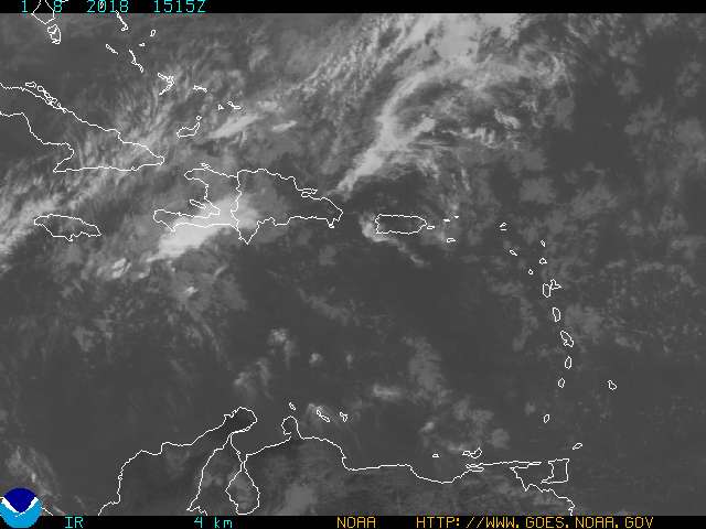

Convection has increased north of Puerto Rico and take a look at the long range radar from San Juan how much precipitation is north of the island.
That is the interaction of a tropical wave and an upper trough in the area.The big question is if something will form from this area in the next few days.
0 likes
-
WindRunner

- Category 5

- Posts: 5806
- Age: 35
- Joined: Fri Jul 29, 2005 8:07 pm
- Location: Warrenton, VA, but Albany, NY for school
- Contact:
I thought this needed posting from another thread where Cookiely posted it. AFD from Tampa about development.
FXUS62 KTBW 020700
AFDTBW
WEST CENTRAL AND SOUTHWEST FLORIDA FORECAST DISCUSSION
NATIONAL WEATHER SERVICE TAMPA BAY AREA - RUSKIN FL
300 AM EDT SUN OCT 2 2005
.SHORT TERM (TODAY-TUE)...HIGH PRESSURE TO CONTINUE TO RIDGE OVER THE
AREA FROM THE NE AS NEWLY FORMED TROPICAL STORM STAN MOVES ACROSS THE
YUCATAN PENINSULA AND INTO THE SOUTHERN GULF/BAY OF CAMPECHE WHILE
ANOTHER TROPICAL WAVE MOVES THROUGH THE WESTERN ATLANTIC AND
APPROACHES THE EASTERN FL COAST BY TUESDAY. THIS WILL ALLOW FOR
INCREASING POPS THROUGH THE PERIOD AND ALLOW NEAR RECORD WARM TEMPS
TO COOL OFF A COUPLE OF DEGREES. STILL KEEPING ONLY SCATTERED CHANCES
IN THE FORECAST FOR NOW AS MODELS DIFFER A BIT ON THE STRENGTH AND
LOCATION OF THE TROPICAL WAVE WITH THE NAM STRONGER AND FURTHER WEST
THAN THE GFS. WILL SEE HOW THIS RESOLVES WITH THE FUTURE RUNS TO SEE
WHERE AND IF WILL NEED TO INCREASE POPS. TEMPS WILL CONTINUE ABOVE
NORMAL...BUT LOWER FROM HIGHS IN THE LOWER 90S TO UPPER 80S BY
TUESDAY AND LOWS WILL REMAIN FAIRLY UNIFORM IN THE LOWER TO MID 70S
WITH THE MOISTURE AND RAIN IN PLACE. MODERATE E/NE WINDS TO CONTINUE
ACROSS THE AREA THROUGH THE PERIOD.
.LONG TERM (TUE NIGHT-SAT)...MODELS IN BETTER AGREEMENT WITH GENERAL
WET PATTERN THRU THE PERIOD. RIDGING ALOFT CENTERED OVER THE EASTERN
U.S. INTO THE DEEP SOUTH WHILE TUT LOW MOVES FROM THE N CARIB INTO
THE E GULF EARLY IN THE PERIOD. SFC REFLECTION TROPICAL WAVE MOVES
INTO THE EASTERN GULF AS WELL. BOTH FEATURES THEN STALL IN THE
EASTERN GULF THRU MID WEEK. THE AREA WILL BE ON THE WETTER EASTERN
SIDE OF WAVE WITH UPPER SUPPORT TO BRING ABOVE NORMAL DIURNAL SCT
POPS. TROUGHINESS TO SET UP AND DEEPEN FROM THE GREAT LAKES TO NEW
ENGLAND AND SOUTH TO THE GULF COAST REGION LATE IN THE PERIOD.
ATTENDANT SFC COLD FRONT TO SWEEP THRU THE DEEP SOUTH. THIS EXPECTED
TO PUSH TROPICAL FEATURES BACK OVER THE STATE AHEAD OF COLD FRONT
LATE WEEK INTO SAT AGAIN KEEPING POPS ABOVE NORMAL. WITH ABUNDANT
MOISTURE AND INCREASED CLOUD COVER EXPECTED DAYTIME TEMPS TO HOLD
NEAR CLIMO WITH OVERNIGHT MIN SLIGHTLY ABOVE NORMAL.
&&
.MARINE...MODERATE E/NE WINDS WILL CONTINUE OVER THE COASTAL WATERS
AS HIGH PRESSURE RIDGING REMAINS IN PLACE AND A TROPICAL WAVE
APPROACHES THE AREA FROM THE WEST ATLANTIC BY MID-WEEK. THE CURRENT
SCEC IN PLACE OVER THE OUTER COASTAL WATERS IS CURRENTLY ON TRACK
WITH WINDS AT 15-20KTS...BUT SEAS SLOWER TO RESPOND AND STILL IN THE
3-5FT RANGE. WILL KEEP THE SCEC IN PLACE FOR THE OUTER WATERS AND
MONITOR THE DEVELOPMENT OF THE TROPICAL WAVE TO SEE IF ANYTHING MORE
WILL BE NEEDED.
&&
0 likes
-
cycloneye
- Admin
- Posts: 148836
- Age: 69
- Joined: Thu Oct 10, 2002 10:54 am
- Location: San Juan, Puerto Rico
STATIONARY UPPER LEVEL LOW IS LOCATED ABOUT 420 NM E OF
JACKSONVILLE FLORIDA NEAR 30N73W AND HAS BEEN ENHANCING WIDELY
SCATTERED SHOWERS/TSTMS PRIMARILY NE OF THE BAHAMAS FROM 25N-31N
BETWEEN 66W-76W. HIGH PRESSURE OVER THE MID-LATITUDE W ATLC IS
KEEPING LOW-LEVEL ELY FLOW AROUND 20 KT AND UNSTABLE ESPECIALLY
NEAR LARGE-SCALE LIFTING MECHANISMS LIKE UPPER LOWS. UNSETTLED
WEATHER CONTINUES FARTHER E WITH ANOTHER UPPER LOW NE OF THE
LEEWARD ISLANDS NEAR 21N62W...WITH SCATTERED MODERATE CONVECTION
FROM 18N-26N BETWEEN 59W-67W. THIS UPPER LOW IS STUCK BENEATH A
SLOW-MOVING HIGH NEAR 31N63W ESE OF BERMUDA. A SURFACE TROUGH
IS ALIGNED FROM PUERTO RICO TO 27N72W WITH WIDELY SCATTERED
SHOWERS/TSTMS WITHIN 5 DEGREES E OF THE TROUGH AXIS. THIS
FEATURE HAS PLENTY OF SUPPORT NEAR UPPER TROUGH AXES.
8 AM Discussion about the mess in the western atlantic.
0 likes
Visit the Caribbean-Central America Weather Thread where you can find at first post web cams,radars
and observations from Caribbean basin members Click Here
and observations from Caribbean basin members Click Here
-
inotherwords
- Category 2

- Posts: 773
- Joined: Mon Aug 30, 2004 9:04 pm
- Location: Nokomis, FL

Question for those possibly concerned about this forming similar to Katrina/Rita: when K and R were at this stage, were the NHC forecasts more bullish on both of them developing than they are on this storm? I can't recall.
CLOUDINESS AND SHOWERS EXTEND FROM EASTERN CUBA AND HISPANIOLA
ACROSS THE SOUTHEASTERN BAHAMAS AND THE TURKS AND CAICOS ISLANDS...
AND INTO THE ATLANTIC FOR A FEW HUNDRED MILES. THIS ACTIVITY...
WHICH IS POSSIBLY ASSOCIATED WITH THE REMNANTS OF TROPICAL
DEPRESSION TEN...HAS BECOME MORE CONCENTRATED THIS MORNING NEAR THE
SOUTHEASTERN BAHAMAS. ADDITIONAL DEVELOPMENT OF THIS SYSTEM IS
POSSIBLE DURING THE NEXT DAY OR TWO AS IT MOVES WEST-NORTHWESTWARD
AT ABOUT 10 MPH. AN AIR FORCE RESERVE HURRICANE HUNTER AIRCRAFT IS
SCHEDULED TO INVESTIGATE THE SYSTEM THIS AFTERNOON...IF NECESSARY.
You can get some previous discussions and outlooks from what I can see from ftp://ftp.nhc.noaa.gov/pub/products/nhc/
0 likes
-
Hyperstorm

- Category 5
- Posts: 1500
- Joined: Sun Sep 07, 2003 3:48 am
- Location: Ocala, FL
Even though the current scenario for this surface trough is of unfavorable upper-level winds and extreme disorganization, I would keep an eye on it for sure. There is the forecast of a more favorable upper-level environment starting tomorrow morning. If it materializes, this one could develop fairly steadily.
What catches my attention the most is the building of an enormous upper-level ridge in the Eastern Atlantic! This could prove very interesting for that tropical wave that just moved offshore yesterday.
85* and rising...
What catches my attention the most is the building of an enormous upper-level ridge in the Eastern Atlantic! This could prove very interesting for that tropical wave that just moved offshore yesterday.
85* and rising...
0 likes
-
inotherwords
- Category 2
- Posts: 773
- Joined: Mon Aug 30, 2004 9:04 pm
- Location: Nokomis, FL

-
Ivanhater

- Storm2k Moderator

- Posts: 11217
- Age: 39
- Joined: Fri Jul 01, 2005 8:25 am
- Location: Pensacola
Mobile/Pensacola AFD
.LONG TERM (MONDAY THROUGH SATURDAY)...A DEEP EASTERLY FLOW WILL
PERSIST INTO MID WEEK...WITH RAIN CHANCES GRADUALLY INCREASING FROM
MONDAY THRU WEDNESDAY AS BOTH NAM AND GFS SHOW SOME SORT OF TROPICAL
INFLUENCE (GFS-EASTERLY WAVE...NAM-DEPRESSION) MOVING WESTWARD FROM
FLORIDA INTO THE NORTH CENTRAL AND CENTRAL GULF REGION BY WEDNESDAY.ALSO AROUND MID WEEK...A STRONG UPPER LEVEL SHORTWAVE DRIVES ACROSS
THE GREAT LAKES REGION AND DRAGS A COLD FRONT INTO THE AREA BY
THURSDAY. STILL APPEARS BEST RAIN CHANCES WILL BE WEDNESDAY-THURSDAY
AS THE FRONT ENCOUNTERS DEEP TROPICAL MOISTURE BLANKETED ACROSS THE
DEEP SOUTH. CONSIDERING THE TRAILING RIDGE OF HIGH PRESSURE DROPS
OUT OF CANADA...WOULD EXPECT THE COOLER AIR TO PUSH THE FRONT WELL
SOUTH OF THE OFFSHORE WATERS THURSDAY NIGHT WHERE IT SHOULD REMAIN
THRU THE WEEKEND. THIS SUGGEST BEST RAIN CHANCES FOR FRIDAY-SATURDAY
WOULD REMAIN WELL OFFSHORE. HOWEVER...WILL CONTINUE TO GO WITH LATEST
MEX POPS AND SHOW 30% CHANCE OVER AT LEAST THE FLORIDA PANHANDLE AT
THIS TIME. AS FOR TEMPS...THE COOL CANADIAN RIDGE SHOULD ALLOW INLAND
LOWS TO DIP INTO THE 50S BY NEXT WEEKEND. 39/DARBE
0 likes
-
TropicalBill
- Tropical Wave

- Posts: 9
- Joined: Sat Jul 23, 2005 12:48 pm
- Location: Poinciana, FL
An impressive swirl at about 24.5/69.0 based on link provided by cjrciadt.
http://orca.rsmas.miami.edu/wximages/jet/1_05/anis.html
Large Flare UP
http://orca.rsmas.miami.edu/wximages/jet/1_05/anis.html
Large Flare UP
0 likes
-
WindRunner
- Category 5
- Posts: 5806
- Age: 35
- Joined: Fri Jul 29, 2005 8:07 pm
- Location: Warrenton, VA, but Albany, NY for school
- Contact:
11:30am TWO, slightly positive outlook:
A BROAD AREA OF SHOWERS AND THUNDERSTORMS...ASSOCIATED WITH A
WESTWARD-MOVING TROPICAL WAVE AND AN UPPER-LEVEL LOW...IS CENTERED
A FEW HUNDRED MILES EAST OF THE CENTRAL BAHAMAS. ALTHOUGH
UPPER-LEVEL WINDS ARE CURRENTLY UNFAVORABLE FOR TROPICAL CYCLONE
DEVELOPMENT...THEY COULD BECOME MORE CONDUCIVE OVER THE NEXT FEW
DAYS AS THIS SYSTEM MOVES WESTWARD.
0 likes

-
Brent
- S2K Supporter
- Posts: 38657
- Age: 37
- Joined: Sun May 16, 2004 10:30 pm
- Location: Tulsa Oklahoma
- Contact:
bvigal wrote:Brent wrote:inotherwords wrote:Christy, you are wearing my last nerve.
wearing?
Brent, inotherwords means "wearing on" or "wearing thin", etc. "Christy" seems to enjoy being dramatic. "!...!...!...!"
I know, I was saying she was only "wearing", she was on my last nerve a few days ago...
0 likes
#neversummer
Who is online
Users browsing this forum: No registered users and 41 guests