The Right Front Quadrant of a Hurricane
Moderator: S2k Moderators
Forum rules

The posts in this forum are NOT official forecasts and should not be used as such. They are just the opinion of the poster and may or may not be backed by sound meteorological data. They are NOT endorsed by any professional institution or STORM2K. For official information, please refer to products from the National Hurricane Center and National Weather Service.

The Right Front Quadrant of a Hurricane
There is a meteorologist (I'm not mentioning any names) that believes you do NOT add the forward speed of a hurricane to the wind speed in the right front quadrant of a hurricane. He says that it is the structure of the storm that causes this part of the storm to be more intense and thus have stronger winds. Has this been proven?
0 likes
-
Air Force Met
- Military Met

- Posts: 4372
- Age: 56
- Joined: Tue Jul 08, 2003 9:30 am
- Location: Roan Mountain, TN
Re: The Right Front Quadrant of a Hurricane
Dave R wrote:There is a meteorologist (I'm not mentioning any names) that believes you do NOT add the forward speed of a hurricane to the wind speed in the right front quadrant of a hurricane. He says that it is the structure of the storm that causes this part of the storm to be more intense and thus have stronger winds. Has this been proven?
You don't add the wind speed. That's a myth. If a storm has 100 mph winds and is moving at 15 mph...that does not mean a ship or island in the right front quad will get 115mph sustained winds. It will get 100 mph winds. The winds are the winds. They are measured by the aircraft. If you added the winds (thus 115 mph in our example) then the aircraft would measure 115 mph...and not 100. By and large it is a function of structure rather than forward motion. That's why a storm that is stationary STILL has the strongest winds in that right quadrant usually.
So...the forward speed is factored in some...but you don't add it to get the real winds. A storm with 105 mph winds moving at 10 mph is still going to have 105 mph winds. Even if it speeds up to 30 mph...you won't all of the sudden have a cat 4 because it picked up speed. You will still have a cat 2.
0 likes
Re: The Right Front Quadrant of a Hurricane
Dave R wrote:There is a meteorologist (I'm not mentioning any names) that believes you do NOT add the forward speed of a hurricane to the wind speed in the right front quadrant of a hurricane. He says that it is the structure of the storm that causes this part of the storm to be more intense and thus have stronger winds. Has this been proven?
100% agree with AirforceMet here...you do not add the forward motion to the max wind speed...that is already reflected in whatever measurement is taken by land or aircraft. Those measurements are made relative to a ground observation point or aircraft wing...for example.
As you mention...it's the structure of the storm...relative to the steering environment...that creates this disparity in the windfield.
MW
0 likes
Updating on the twitter now: http://www.twitter.com/@watkinstrack
-
wxmann_91

- Category 5

- Posts: 8013
- Age: 34
- Joined: Fri Jul 15, 2005 2:49 pm
- Location: Southern California
- Contact:
OK, well I have a couple of questions about the left quadrant.
If a storm has 100 mph max winds and is moving at 15 mph, would the left side have 85 mph?
And that correlates with my second question. If a TD had winds of 30 mph, but was moving at 35 mph, would that mean that the left side (relative to storm motion, of course), had calm winds. Is that the reason why fast-moving newly-formed TD's often open up into a wave if they are moving too fast?
0 likes

wxmann_91 wrote:OK, well I have a couple of questions about the left quadrant.
If a storm has 100 mph max winds and is moving at 15 mph, would the left side have 85 mph?
And that correlates with my second question. If a TD had winds of 30 mph, but was moving at 35 mph, would that mean that the left side (relative to storm motion, of course), had calm winds. Is that the reason why fast-moving newly-formed TD's often open up into a wave if they are moving too fast?
I think you're right about that last part. Storms with winds of 30mph are never moving along at 35mph as far as I've seen.
0 likes
-
tornadochaser86
- Tropical Storm

- Posts: 197
- Joined: Fri Sep 23, 2005 11:19 am
- Location: University of South Alabama
- Contact:
-
cyclone_watcher
Re: The Right Front Quadrant of a Hurricane
Air Force Met wrote:By and large it is a function of structure rather than forward motion.
OK your explanation is still opaque in relation to why "structure" and "function of structure" contributes to strongest winds on the right side. Can you please explain.
Can you also explain relative to the explanation below:
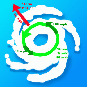
Dr Chris Landsea FAQ:Hurricanes http://www.aoml.noaa.gov/hrd/tcfaq/D6.html wrote:First, the "right side of the storm" is defined with respect to the storm's motion: if the hurricane is moving to the west, the right side would be to the north of the storm; if the hurricane is moving to the north, the right side would be to the east of the storm, etc.
In general, the strongest winds in a hurricane are found on the right side of the storm because the motion of the hurricane also contributes to its swirling winds. A hurricane with a 90 mph [145 km/hr] winds while stationary would have winds up to 100 mph [160 km/hr] on the right side and only 80 mph [130 km/hr] on the left side if it began moving (any direction) at 10 mph [16 km/hr].
Note that the U.S. National Hurricane Center and other forecasting center advisories already take this asymmetry into account and, in this case, would state that the highest winds were 100 mph [160 km/hr].
0 likes
-
Air Force Met
- Military Met
- Posts: 4372
- Age: 56
- Joined: Tue Jul 08, 2003 9:30 am
- Location: Roan Mountain, TN
wxmann_91 wrote:OK, well I have a couple of questions about the left quadrant.
If a storm has 100 mph max winds and is moving at 15 mph, would the left side have 85 mph?
And that correlates with my second question. If a TD had winds of 30 mph, but was moving at 35 mph, would that mean that the left side (relative to storm motion, of course), had calm winds. Is that the reason why fast-moving newly-formed TD's often open up into a wave if they are moving too fast?
100 mph is the MAX the storm will have based on obs at a fixed point. ANYWHERE else in the storm will be less. The left side will not have 85 mph because of movement alone...it might be 80 or 75. 100 MPH sustained winds means that the max 1 minute wind in the storm is 100 at one given point...maybe a couple square miles out of thousands. Everywhere else it will be less than 100. It's a function of gradient setup and other physics.
0 likes
-
Air Force Met
- Military Met
- Posts: 4372
- Age: 56
- Joined: Tue Jul 08, 2003 9:30 am
- Location: Roan Mountain, TN
Re: The Right Front Quadrant of a Hurricane
cyclone_watcher wrote:Air Force Met wrote:By and large it is a function of structure rather than forward motion.
OK your explanation is still opaque in relation to why "structure" and "function of structure" contributes to strongest winds on the right side. Can you please explain.
Can you also explain relative to the explanation below:Dr Chris Landsea FAQ:Hurricanes http://www.aoml.noaa.gov/hrd/tcfaq/D6.html wrote:First, the "right side of the storm" is defined with respect to the storm's motion: if the hurricane is moving to the west, the right side would be to the north of the storm; if the hurricane is moving to the north, the right side would be to the east of the storm, etc.
In general, the strongest winds in a hurricane are found on the right side of the storm because the motion of the hurricane also contributes to its swirling winds. A hurricane with a 90 mph [145 km/hr] winds while stationary would have winds up to 100 mph [160 km/hr] on the right side and only 80 mph [130 km/hr] on the left side if it began moving (any direction) at 10 mph [16 km/hr].
Note that the U.S. National Hurricane Center and other forecasting center advisories already take this asymmetry into account and, in this case, would state that the highest winds were 100 mph [160 km/hr].
That answer is the structure of which I speak. Motion is taken into account. However...a stationary storm with max winds of 100 will still only have the max winds in one quad...usually the quad with some east or north east component. You will find that 100 mph in only one area...that is why it is the "MAX"
0 likes
-
NC George

- Category 2

- Posts: 635
- Age: 55
- Joined: Sun Sep 14, 2003 11:44 am
- Location: Washington, NC, USA
Ok, AirForceMet, I calling you to task on this. You have given conflicting answers on this issue in the past (Hurricane Dennis,) and it is quite confusing to even me where you stand. You have in the past at various times agreed with me and disagreed with me about whether forward speed is added into the wind speed.
From several sources (other than yourself) here's what I understand:
When an advisory is issued by the NHC, the wind speed reported on the advisory is the max reported windspeed. This is the on-the-ground (actually 10m above, but that's ok for the purpose of this discussion) windspeed. You don't add anything to this number. Typically this will be the wind on the right front side of the storm.
Where the confusion comes is what about the rest of the storm. I (and many others) say the total windspeed is derived from two component: cyclonic winds and forward motion winds. I will call these components the forward component and the cyclonic component. From the total speed and forward speed, can you figure the windspeed on the opposite side of the storm? I say yes! It is the max speed - 2xforward speed (one forward speed to remove the forward component of the windspeed and get true cyclonic and one more to get the windspeed on the left side.)
Now I believe what AirForceMet is saying is although the winds are less in other portions of the storm, but it has nothing to do with forward motion. That goes against everything I have learned in 25 years of hurricane study.
For instance, using the above formula, I was able to predict Dennis (of this year) being declared a Cat 4 an hour before it was officially released. How? There was a recon report of 120 mph winds on the southwest side of the storm, and the forward speed was 15 mph. Add 2x the forward speed and you get 150 mph winds in the NE quadrent (Dennis was moving N in the GOM at this point.) I immediatly posted my finding, and some people dismissed my calculations, and demanded I wait for the official word. Well, about an hour later it came in - at exactly the speed I had previously calculated. Look in the archives of this message board, it's in here. According to AirForceMet, this was luck. I say it's physics and math.
0 likes
-
WeatherEmperor
- S2K Supporter

- Posts: 4806
- Age: 41
- Joined: Thu Sep 04, 2003 2:54 pm
- Location: South Florida
-
brunota2003

- S2K Supporter
- Posts: 9476
- Age: 35
- Joined: Sat Jul 30, 2005 9:56 pm
- Location: Stanton, KY...formerly Havelock, NC
- Contact:
This, straight from the NHC FAQ page, settles the debate, somewhat:
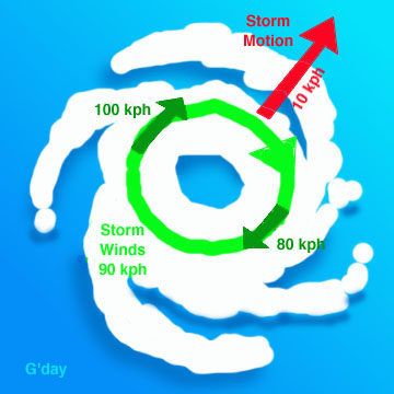
Subject: D6) Why are the strongest winds in a hurricane typically on the right side of the storm?
First, the "right side of the storm" is defined with respect to the storm's motion: if the hurricane is moving to the west, the right side would be to the north of the storm; if the hurricane is moving to the north, the right side would be to the east of the storm, etc.
In general, the strongest winds in a hurricane are found on the right side of the storm because the motion of the hurricane also contributes to its swirling winds. A hurricane with a 90 mph [145 km/hr] winds while stationary would have winds up to 100 mph [160 km/hr] on the right side and only 80 mph [130 km/hr] on the left side if it began moving (any direction) at 10 mph [16 km/hr].
Note that the U.S. National Hurricane Center and other forecasting center advisories already take this asymmetry into account and, in this case, would state that the highest winds were 100 mph [160 km/hr].
For tropical cyclones in the Southern Hemisphere, these differences are reversed: the strongest winds are on the left side of the storm. This is because the winds swirl clockwise south of the equator in tropical cyclones.
0 likes
-
tornadochaser86
- Tropical Storm
- Posts: 197
- Joined: Fri Sep 23, 2005 11:19 am
- Location: University of South Alabama
- Contact:
Who is online
Users browsing this forum: No registered users and 145 guests