Katrina H-Wind Analysis, marginal 3 at landfall
Moderator: S2k Moderators
Forum rules

The posts in this forum are NOT official forecasts and should not be used as such. They are just the opinion of the poster and may or may not be backed by sound meteorological data. They are NOT endorsed by any professional institution or STORM2K. For official information, please refer to products from the National Hurricane Center and National Weather Service.
-
curtadams
- S2K Supporter

- Posts: 1122
- Joined: Sun Aug 28, 2005 7:57 pm
- Location: Orange, California
- Contact:
Are there any photos of areas with roofs entirely ripped off due to Katrina? I looked at a lot of sat pics of the MS coast and the results were always the same - total, utter devastation up to the surge line, then houses with no-to-moderate roof damage. By the Fujitsu tornado scale (which admittedly isn't calibrated to real windspeeds either) that's low to mid F1 damage, suggesting even long gusts were probably less than 100 mph (F1 is up to 112). I saw that even in Waveland - Waveland differed in that it had a frighteningly large surge area.
0 likes

Good post StormSkeptic, I agree with you on some of those points except one...IMO, in weakening storms such as Katrina and Ivan, they seem to focus all their available energy left into the NE quadrant. Also, with the dry air intrustions we see commonly on the west side of weakening hurricanes, I think this acts to build convection in the east eyewall. Look at Ivan, once the dry air eroded the western side, convection exploded all over the east and northern quad...We had gust to over hurricane force by 9 or 10pm. The eye didnt hit land until 2-3pm. Same thing happened with Katrina, look at all the convection on the eastern side of the eye that developed as the storm weakened. Now, the point Im trying to make is as this convection develops, high winds are transported down from the upper levels in the form of high energy gust that streak about the area. While the sustained winds may be on the down swing, there are still very potent gust that do quite a bit of damage in the area of deepest convection. I believe one of these gust was recorded during Ivan in Gulf Shores that was 145mph. Thats nothing to sneeze at especially since I believe the strongest gust may have been further east near Perdido Key at around 150-155mph. The thing is though, these are very isolated. And it is my thought that the same thing happened with Katrina. Derek, is there any logic in my thinking?
0 likes
-
Matt-hurricanewatcher
How can a hurricane go from 160 to 120 or maybe 130 mph at landfall. With in 6 hours? That maybe a reason why Ethel that cat5 that went from a cat5 then down to a tropical storm at landfall. Maybe for the same reason?
http://weather.unisys.com/hurricane/atl ... /track.gif
http://weather.unisys.com/hurricane/atl ... /track.gif
0 likes
-
timNms
- Category 5

- Posts: 1371
- Age: 63
- Joined: Sat Oct 19, 2002 5:45 pm
- Location: Seminary, Mississippi
- Contact:
curtadams wrote:Are there any photos of areas with roofs entirely ripped off due to Katrina? I looked at a lot of sat pics of the MS coast and the results were always the same - total, utter devastation up to the surge line, then houses with no-to-moderate roof damage. By the Fujitsu tornado scale (which admittedly isn't calibrated to real windspeeds either) that's low to mid F1 damage, suggesting even long gusts were probably less than 100 mph (F1 is up to 112). I saw that even in Waveland - Waveland differed in that it had a frighteningly large surge area.
I can take you to a house that is about 15 miles east of me, between Laurel and Collins, MS. The entire roof was taken off. My guess would be that a tornado did it, but I suppose it's possible that the winds in the eyewall of Katrina ripped it off. I didn't think the wind would EVER stop blowing here once we got into the eyewall!
0 likes
-
StormSkeptic
- Tropical Low

- Posts: 35
- Joined: Tue Sep 30, 2003 8:40 pm
- Location: New Jersey
A hurricane can go from 160 to 130 very quickly because of the changing dynamics of the strom. To get those extreme speeds requires perfect conditions, typically over a a very small area - sort of like an engine working on all eight cylinders in perfect unision. But, any imperfection in the timing (or storm conditions) doesn't allow the engine to work at its peak potential, even if all eight cylinders are firing. And if you lose a cylinder - the engine really falls apart and can spurter quickly.
0 likes
Dry air, land interaction, low ocean heat content near shore? Who's to say this all happened in 6 hours? Im not to sure what recon showed, I had to evacuate so I wasnt around during the afternoon or evening. Katrina was probably gradually weakening since peaking out a few hours earlier. Another thought I've had was that Katrina had a large eye, therefore less of a pressure gradient and once she interacted with land the pressure gradient was even less, thus the winds spreading out and weakening. We had hurricane force gust all the way over here in Pensacola, albeit barely a gust to 74 I believe. Just goes to show, it takes perfect condtions for a cat 5 to make landfall. Whew, my hands hurt...just adding my 2 cents to this great discussion.
0 likes
-
Derek Ortt
-
timNms
- Category 5
- Posts: 1371
- Age: 63
- Joined: Sat Oct 19, 2002 5:45 pm
- Location: Seminary, Mississippi
- Contact:
Droop12 wrote:Dry air, land interaction, low ocean heat content near shore? Who's to say this all happened in 6 hours? Im not to sure what recon showed, I had to evacuate so I wasnt around during the afternoon or evening. Katrina was probably gradually weakening since peaking out a few hours earlier. Another thought I've had was that Katrina had a large eye, therefore less of a pressure gradient and once she interacted with land the pressure gradient was even less, thus the winds spreading out and weakening. We had hurricane force gust all the way over here in Pensacola, albeit barely a gust to 74 I believe. Just goes to show, it takes perfect condtions for a cat 5 to make landfall. Whew, my hands hurt...just adding my 2 cents to this great discussion.
Something I found odd was before our electricity went off, we were glued to the tv watching WDAM (Hattiesburg/Laurel). The met was on there showing a satellite loop of Katrina. She was in the vicinity of Picayune. Oddly enough, she was looking as if she were strengthening instead of weakening. The dark reds had wrapped all the way around the eyewall. Anyone know what may have caused that? The local Met even commented that it appeared she was strengthening over land!
0 likes
[quote]I can take you to a house that is about 15 miles east of me, between Laurel and Collins, MS. The entire roof was taken off.
My guess, if the severe damage is that isolated that the house probably A. Wasnt built to well, or was just old. B. A streak of wind did the damage, the same streaks I was speaking of in my other posts.
I pretty sure the folks who work with the Doppler on Wheels dismissed the idea that tornadoes occur in the eyewall, I've always been a skeptic myself. I have an interesting illustration though of the so called "mini-vorticies", which I guess could be considered tornado-like, but arent caused by atomospheric processes. Let me see if I can find it and I'll try to post it, for anyone interested.
0 likes
-
MGC

- S2K Supporter
- Posts: 5939
- Joined: Sun Mar 23, 2003 9:05 pm
- Location: Pass Christian MS, or what is left.
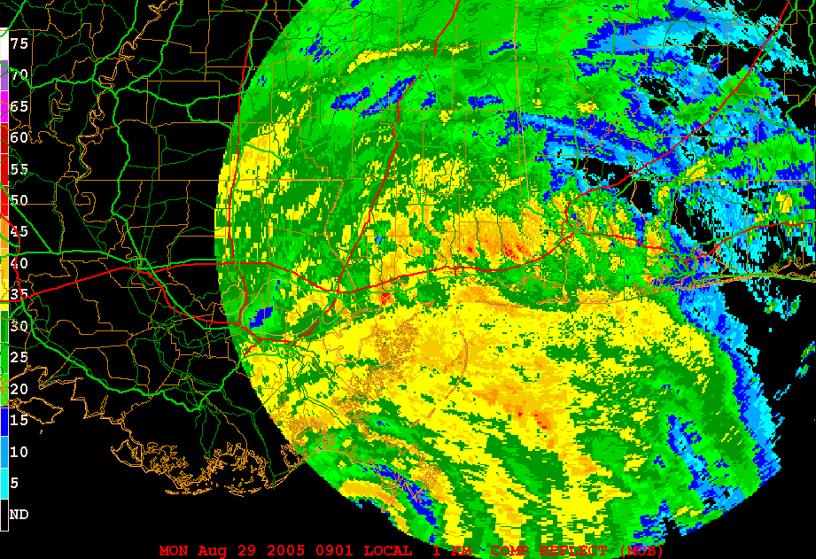
Check out this radar loop of Katrina making landfall. It was taken from the Mobile radar. Granted, the radar beam was viewing a high level in the storm. Notice the burst of deep convection in the northern and eastern eyewall just as Katrina makes landfall in Mississippi.
http://www.atmo.arizona.edu/products/radar/kat_mob_rad.gif
This convective burst likely produced winds well in excess of 100KTS. If any of you doubt it take a ride over to Diamondhead and check out the wind damage.......MGC
http://www.atmo.arizona.edu/products/radar/kat_mob_rad.gif
This convective burst likely produced winds well in excess of 100KTS. If any of you doubt it take a ride over to Diamondhead and check out the wind damage.......MGC
0 likes
-
wxmann_91

- Category 5
- Posts: 8013
- Age: 34
- Joined: Fri Jul 15, 2005 2:49 pm
- Location: Southern California
- Contact:
timNms wrote:Oddly enough, she was looking as if she were strengthening instead of weakening. The dark reds had wrapped all the way around the eyewall. Anyone know what may have caused that? The local Met even commented that it appeared she was strengthening over land!
Quite possible. Satellite images show that as it was making landfall in Mississippi, the eye got less ragged and cleared out a bit. I posted a graphic in another thread, which showed the heat content in the Gulf. The area off the coast of Louisiana had very high heat content, which could've maintained Katrina's strength. Between that area and the Loop Current, there was a huge area of very low heat content, which would explain the weakening.
0 likes
-
timNms
- Category 5
- Posts: 1371
- Age: 63
- Joined: Sat Oct 19, 2002 5:45 pm
- Location: Seminary, Mississippi
- Contact:
Droop12 wrote:I can take you to a house that is about 15 miles east of me, between Laurel and Collins, MS. The entire roof was taken off.
My guess, if the severe damage is that isolated that the house probably A. Wasnt built to well, or was just old. B. A streak of wind did the damage, the same streaks I was speaking of in my other posts.
I pretty sure the folks who work with the Doppler on Wheels dismissed the idea that tornadoes occur in the eyewall, I've always been a skeptic myself. I have an interesting illustration though of the so called "mini-vorticies", which I guess could be considered tornado-like, but arent caused by atomospheric processes. Let me see if I can find it and I'll try to post it, for anyone interested.
Actually, this was a newer brick house. I'm not sure how well built it was.
0 likes
Thats exactly what I was trying to say MGC. I bet the winds werent sustained near 130mph, but winds of 115-120mph for about 2 or 3 hours can be just as damaging. What the most extreme wind damage was caused by was probably high energy burst of winds that are transported to the surface from all that convection. Atleast thats my theory.
0 likes
DoctorHurricane2003 wrote:The tsunami analogy was poor, especially considering that they move anywhere between 200-700 mph, with the global tsunamis in the upper range. Hurricanes don't move that fast.
But yes I do agree with the point stated that it does take longer for the surge to die down vs. the wind. We experienced it in Ivan last year, and Katrina this year. Considering that water is a denser substance than air, once it gets momentum, its going to keep going longer vs. air.
Its almost similar with temperature relations of air vs. water. We all know it takes much longer for water to heat/cool vs. air.........and that same general idea can be used with the movement of both.
Not that I agree that Katrina was a 100 KT storm, that's just bs. I believe it will be the job of this next generation of meteorologists to refine these new tools such as SFMR to show the winds more accurately, and to determine surface winds vs. flight level winds more accurately.
you misunderstood my point what i was saying was surge doesn't decrease beacuse the winds decrease same way with a 9.0 earthquake the tsunami doesn't weaken beacuse its getting push farther away from the earthquake.like the earthquake in chile in 1960 the tsunami hit japan halfway around the world at 9.0 strength why beacuse water is very hard to slow down it needs friction and that friction is land.
0 likes
-
curtadams
- S2K Supporter
- Posts: 1122
- Joined: Sun Aug 28, 2005 7:57 pm
- Location: Orange, California
- Contact:
timNms wrote:I can take you to a house that is about 15 miles east of me, between Laurel and Collins, MS. The entire roof was taken off. My guess would be that a tornado did it, but I suppose it's possible that the winds in the eyewall of Katrina ripped it off. I didn't think the wind would EVER stop blowing here once we got into the eyewall!
Yeah, I'm sure glad I wasn't in it. I was hoping to see if there was a reasonably large area with numerous roofs off. One roof - like you say could be a tornado, also could be a lazy roofer or just one of those flukes. Unfortunately I can't take you up on the offer to go in person because I'm on the West Coast. If I were closer I would have loaded an SUV with relief supplies and just gone in.
0 likes
-
HurricaneBill
- Category 5
- Posts: 3420
- Joined: Sun Apr 11, 2004 5:51 pm
- Location: East Longmeadow, MA, USA
Matt-hurricanewatcher wrote:How can a hurricane go from 160 to 120 or maybe 130 mph at landfall. With in 6 hours? That maybe a reason why Ethel that cat5 that went from a cat5 then down to a tropical storm at landfall. Maybe for the same reason?
http://weather.unisys.com/hurricane/atl ... /track.gif
Honestly, I think that was an error in the readings. I think Ethel probably peaked as a Category 3 at most, or more likely a Category 2.
However, Ethel was a strong Category 1 at landfall. I think sustained winds of 90 mph were recorded.
0 likes
Not suggesting anyone should do this on a public road, but if people had ever rode a motor bike at 250 km/h, or 135 knots, they would have a better comprehension of what that sustained wind speed means in terms of pressure level. 220 km/h (118 kt) is ok, there is a lot of wind but you can cope with it with little problem. But at 250 km/h (135 kt) it’s a very different story because on a motorbike without a fairing to push the wind-blast over you, you can barely hang on to the handle bars, even when tucked low over the fuel tank. The pressure-drop over your shoulders and back tries to lift your butt off the seat at that pressure level. If you were to get hit by a 15-20% faster gust, at that point it would pull you off the motorbike. (professional riders have an aerodynamic hump built into their back leathers in order to help reduce this tendency to lift the rider off the bike).
That difference of just 17 knots—about only half of the category span of upper Cat 3 speed range!—means a great deal in terms of destructive potential. i.e. a strong Cat 3 will be far more damaging than a low Cat 3. The bottom line is this. If you still have any trees or boughs upright then you definitely did not receive characteristic cat 4 sustained winds. Zip! If many of the remaining ‘trees’ in the area are stripped of branches but otherwise still standing, then it’s doubtful you even received sustained low Cat 3 winds. I would look at the overall damage to foliage (of different types) if I wanted to estimate the relative ferocity of winds, in the absence of direct data. I would not even think it worthwhile to attempt to estimate approximate sustained winds from building damage.
That difference of just 17 knots—about only half of the category span of upper Cat 3 speed range!—means a great deal in terms of destructive potential. i.e. a strong Cat 3 will be far more damaging than a low Cat 3. The bottom line is this. If you still have any trees or boughs upright then you definitely did not receive characteristic cat 4 sustained winds. Zip! If many of the remaining ‘trees’ in the area are stripped of branches but otherwise still standing, then it’s doubtful you even received sustained low Cat 3 winds. I would look at the overall damage to foliage (of different types) if I wanted to estimate the relative ferocity of winds, in the absence of direct data. I would not even think it worthwhile to attempt to estimate approximate sustained winds from building damage.
0 likes

I have read every post in this thread with great interest. A few things come to mind that I think sum things up:
1) We clearly need a better way to classify hurricanes as a Dennis with a very small area of strong winds is clearly a very different storm than a Katrina with a much larger area of strong winds - each with thier own miseries, to be sure...but in the same class? No one wants to buy into that theory.
2) The length of time that the winds hit an area make a great impact, so we probably need to think about a little more than the simple 60-second sustained wind test we have now. Ex. Ivan & Katrina hammered areas for hours on end, other smaller & faster storms moved through areas much quicker ex. Dennis, Charley
3) Storm surge does not decrease as wind speed decreases - this must be hammered to the public so they get out of the storm surge areas
4) It will take a great deal of time and we may never know just how strong the winds were at first landfall with Katrina because the storm surge was so devestating in those same areas - would roofs have been ripped off and trees snapped if they hadn't been slammed by a wall of water?
5) It seems both last season and this season brought more questions than answers...but no matter what the storm or how bad someone else says it is, if you are living it, it is a nightmare...and you are probably counting your blessings and saying, it could have been worse.
May we all have brighter skies and many more "fish" in our furture!
0 likes

Just a note about damage -- it's amazing to me that even with a Category 5, trees can be left standing. Andrew and Labor Day storm photographs shows trees completely stripped, but some still standing and with a few branches left.
Trees are just amazing. Also, a big difference between pines, palms, and hardwoods like Mahogany in the Keys, for example.
Trees are just amazing. Also, a big difference between pines, palms, and hardwoods like Mahogany in the Keys, for example.
0 likes
-
wxmann_91
- Category 5
- Posts: 8013
- Age: 34
- Joined: Fri Jul 15, 2005 2:49 pm
- Location: Southern California
- Contact:
Recurve wrote:Just a note about damage -- it's amazing to me that even with a Category 5, trees can be left standing. Andrew and Labor Day storm photographs shows trees completely stripped, but some still standing and with a few branches left.
Trees are just amazing. Also, a big difference between pines, palms, and hardwoods like Mahogany in the Keys, for example.
Yes, palm trees have notoriously strong roots. It is nearly impossible to uproot a palm.
-------------------------------------------------------------------------------------
Reading this topic, I realize why all the rest of the countries use 10-min sustained wind instead of 1-min. Perhaps that would work better in situations like these.
0 likes
Who is online
Users browsing this forum: No registered users and 94 guests