99L Invest,Comments,Sat Pics,Models Thread
Moderator: S2k Moderators
Forum rules

The posts in this forum are NOT official forecasts and should not be used as such. They are just the opinion of the poster and may or may not be backed by sound meteorological data. They are NOT endorsed by any professional institution or STORM2K. For official information, please refer to products from the National Hurricane Center and National Weather Service.


HurricaneQueen wrote:Gee, the CLIP has it heading for my house!!! Obviously not worried about it. However, our least favorite on camera weather personality (Read:not a MET) stated this morning that we should expect a very breezy weekend in the Naples/Ft.Myers area from 99L. Go figure. He usually downplays everything even with a storm headed straight for us. If it is moving away from the area, I find it hard to believe we would feel any effects.
Lynn
"Pressure gradient" the difference between the big high to the north and the distrubance to the south same as all the east and central gulf. The tides are supposed to 1 to 3 feet above normal on the eastern side of La. and southern Miss.
Sorry bout spelling, I miss spellcheck.
0 likes


HURAKAN wrote:
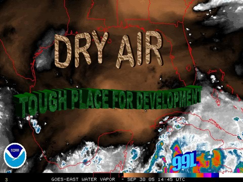
I'd love to think that would kill this thing, but the dry air would have to stay there--just remember how recent Rita was and how fast these things can change. The 5 day AVN relative humidity model shows rapid moistening of the Gulf. In only 48 hours from now the eastern half of the Gulf will have >60%, and half of that area--the southern part that is most relevant to us will be 80-100%. So, as you can see, the news is not that good.
http://weather.unisys.com/aviation/48h/avn_rh_48h.html
0 likes
-
jasons2k

- Storm2k Executive

- Posts: 8278
- Age: 52
- Joined: Wed Jul 06, 2005 12:32 pm
- Location: The Woodlands, TX
hicksta wrote:Hmm, i dont like how Joe b mentioned how the ridge might weaken allowing a more northward turn to accur sending her more northward.
I wasn't thrilled to see that either. Hopefully next week's front will push it away, but NWS HGX is now saying the front may be delayed....and moisture is expected to increase from the south.
0 likes


-
WeatherEmperor
- S2K Supporter

- Posts: 4806
- Age: 41
- Joined: Thu Sep 04, 2003 2:54 pm
- Location: South Florida
-
WeatherEmperor
- S2K Supporter
- Posts: 4806
- Age: 41
- Joined: Thu Sep 04, 2003 2:54 pm
- Location: South Florida

-
cycloneye

- Admin
- Posts: 148836
- Age: 69
- Joined: Thu Oct 10, 2002 10:54 am
- Location: San Juan, Puerto Rico
Brent wrote:HOWEVER... ANOTHER AIR FORCE RESERVE
AIRCRAFT IS SCHEDULED TO INVESTIGATE THE SYSTEM LATE TONIGHT OR
SATURDAY...IF NECESSARY.
Almost sounds like they have one for tonight AND the one tomorrow.
But go to the recon thread and look at what I posted about the plan of the day.
0 likes
Visit the Caribbean-Central America Weather Thread where you can find at first post web cams,radars
and observations from Caribbean basin members Click Here
and observations from Caribbean basin members Click Here
-
Brent
- S2K Supporter
- Posts: 38641
- Age: 37
- Joined: Sun May 16, 2004 10:30 pm
- Location: Tulsa Oklahoma
- Contact:
cycloneye wrote:Brent wrote:HOWEVER... ANOTHER AIR FORCE RESERVE
AIRCRAFT IS SCHEDULED TO INVESTIGATE THE SYSTEM LATE TONIGHT OR
SATURDAY...IF NECESSARY.
Almost sounds like they have one for tonight AND the one tomorrow.
But go to the recon thread and look at what I posted about the plan of the day.
OK... but they shouldn't have said later tonight.
0 likes
#neversummer
-
Rainband
WEST CENTRAL AND SOUTHWEST FLORIDA FORECAST DISCUSSION
NATIONAL WEATHER SERVICE TAMPA BAY AREA - RUSKIN FL
130 PM EDT FRI SEP 30 2005
.SHORT TERM (TONIGHT-SUN)...
AN UPPER RIDGE REMAINS ACROSS THE SOUTHEAST U.S. AS A WEAK LOW
LINGERS OVER THE ATLANTIC WATERS EAST OF THE BAHAMAS DURING THE
WEEKEND. MEANWHILE AT THE SURFACE THE CWFA CONTINUES SANDWICHED
BETWEEN EASTWARD MOVING HIGH PRESSURE OVER THE ATLANTIC WATERS OF
NEW ENGLAND AND A TROPIC WAVE EXITING THE CARIBBEAN SEA AND
ENTERING THE SOUTHERN GULF OF MEXICO THROUGH THE PERIOD. THESE TWO
SYSTEMS MAINTAIN A TIGHT GRADIENT WITH A ROBUST EASTERLY FLOW ACROSS
THE CWFA. MODELS INDICATE A SLIGHT DRYING TREND SUN AFTERNOON/ WITH
THE TROPICAL WAVE EXPECTED TO MOVE AWAY/ BUT THE ONGOING FORECAST
ALREADY IS IN THE LOW END SCATTERED CATEGORY SO WILL LEAVE AS IS.
TEMPS GENERALLY WILL RUN ABOVE CLIMO BY A COUPLE OF DEGREES...HOWEVER
HAVE LOWERED MINS IN THE NORTH JUST A TAD TO FALL IN LINE WITH RECENT
OBS.
.LONG TERM (SUN NIGHT-FRI)...THE NEXT WORKWEEK APPEARS TO BE A BIT
MORE UNSETTLED WITH DEEPER MOISTURE RETURNING FROM A SERIES OF
EASTERLY WAVES...WHICH COALESCE INTO AN UPPER LOW SOMEWHERE OVER
THE GULF BY TUE OR WED AND CONTINUES THROUGH THURSDAY. MORE ON THIS
IN A MOMENT.
FOR SUNDAY NIGHT/MONDAY...THE NAM CONTINUES TO FLIP-FLOP REGARDING
AN INDIVIDUAL EASTERLY WAVE WITH A GOOD PUSH OF MOISTURE ACROSS
NORTH FLORIDA/SOUTH GEORGIA. MEANWHILE...THE GFS HAS BEEN FAIRLY
CONSISTENT IN MAINTAINING RELATIVELY DRY AIR ABOVE SUBSIDENCE
INVERSION ASSOCIATED WITH MID ATLANTIC SFC HIGH AND RIDGE PRESSING
ACROSS THE SOUTHEAST AND INTO FLORIDA. SO...ONE MORE DAY OF
CONTINUED FRESH EASTERLY FLOW WITH ONLY AN UPTICK IN PRECIPITATION
CHANCES ACROSS THE NORTH HALF OF THE AREA.
BY TUESDAY...THE DEEPER MOISTURE ROLLS IN WHICH SHOULD INCREASE
CHANCES AND COVERAGE OF PRECIPITATION. IN GENERAL...THE SAME GOES
FOR WEDNESDAY THROUGH FRIDAY AS WEAK AND PERHAPS BROAD UPPER LOW
DEVELOPS IN THE SOUTH CENTRAL GULF AND FLORIDA REMAINS ON THE WET
SIDE OF THINGS. HAVE DROPPED BACK ON WIND SPEED THURS/FRI AS
SOME TYPE OF INVERTED TROUGH SETS UP. LATER FRIDAY REMAINS IN
QUESTION AS GFS HAS BACKED OFF ON THE WIND SHIFT TO THE NORTHEAST...
AND WILL ADJUST AS WE GET CLOSER TO THE EVENT.
THE ITEM OF CONCERN REMAINS THE POTENTIAL FOR A BROAD UPPER LOW
WITH VIRTUALLY NO COLD-CORE CHARACTERISTICS "FESTERING" IN THE
SOUTHERN GULF OR NORTHERN CARIBBEAN THIS TIME OF YEAR. THERE`S
PLENTY OF DISORGANIZED MOISTURE IN THE CARIBBEAN NOW...AND WE`LL HAVE
TO REMAIN VIGILANT FOR THE POSSIBILITY OF TROPICAL DEVELOPMENT
SOMETIME DURING THE NEXT 5 DAYS OR SO. STAY TUNED.
&&
.MARINE...HIGH PRESSURE TO THE NORTH AND A TROPICAL WAVE TO THE SOUTH
KEEP A TIGHT GRADIENT ACROSS THE COASTAL WATERS THROUGH MUCH OF THE
PERIOD WITH WIND SPEEDS APPROACHING SCEC LEVELS LATE SAT INTO SUN.
SINCE THESE ARE NOT EXPECTED TO MEET CRITERIA UNTIL SAT NIGHT WILL
NOT HEADLINE...BUT WILL PLACE IN THE SYNOPSIS. AS THE PREVIOUSLY
MENTIONED SYSTEMS MOVE AWAY THE GRADIENT WILL BEGIN TO RELAX WITH
WINDS DROPPING DOWN TO INTO THE 15KT RANGE FOR EARLY NEXT WEEK.
&&
.FIRE WEATHER...NO CONCERNS.
&&
.PRELIMINARY POINT TEMPS/POPS...
TPA 74 90 74 90 / 30 30 10 30
FMY 73 91 73 90 / 30 30 20 30
GIF 73 91 73 90 / 20 30 20 30
SRQ 73 90 73 90 / 30 30 20 30
BKV 70 90 71 90 / 20 30 20 30
&&
.TBW WATCHES/WARNINGS/ADVISORIES...NONE.
&&
$$
SHORT TERM...RKR
LONG TERM....BSG
0 likes

There has been a low level vortice tracking WNW observable at times for the last several days. Coordinates were near 15N 70 W then 17.6 N 82W and this afternoon near 18.2 N 83 W. The general direction has been toward or just south of Cozumel. If the shear lets up there would be time for this to intensify into a tropical storm. Recon will find it or not tomorrow morning.
After read the rumors about the ridge Hammer dancing east early next week I still have some concern about this area reaching the gulf.
After read the rumors about the ridge Hammer dancing east early next week I still have some concern about this area reaching the gulf.
0 likes

Who is online
Users browsing this forum: No registered users and 154 guests